2 PM Update…
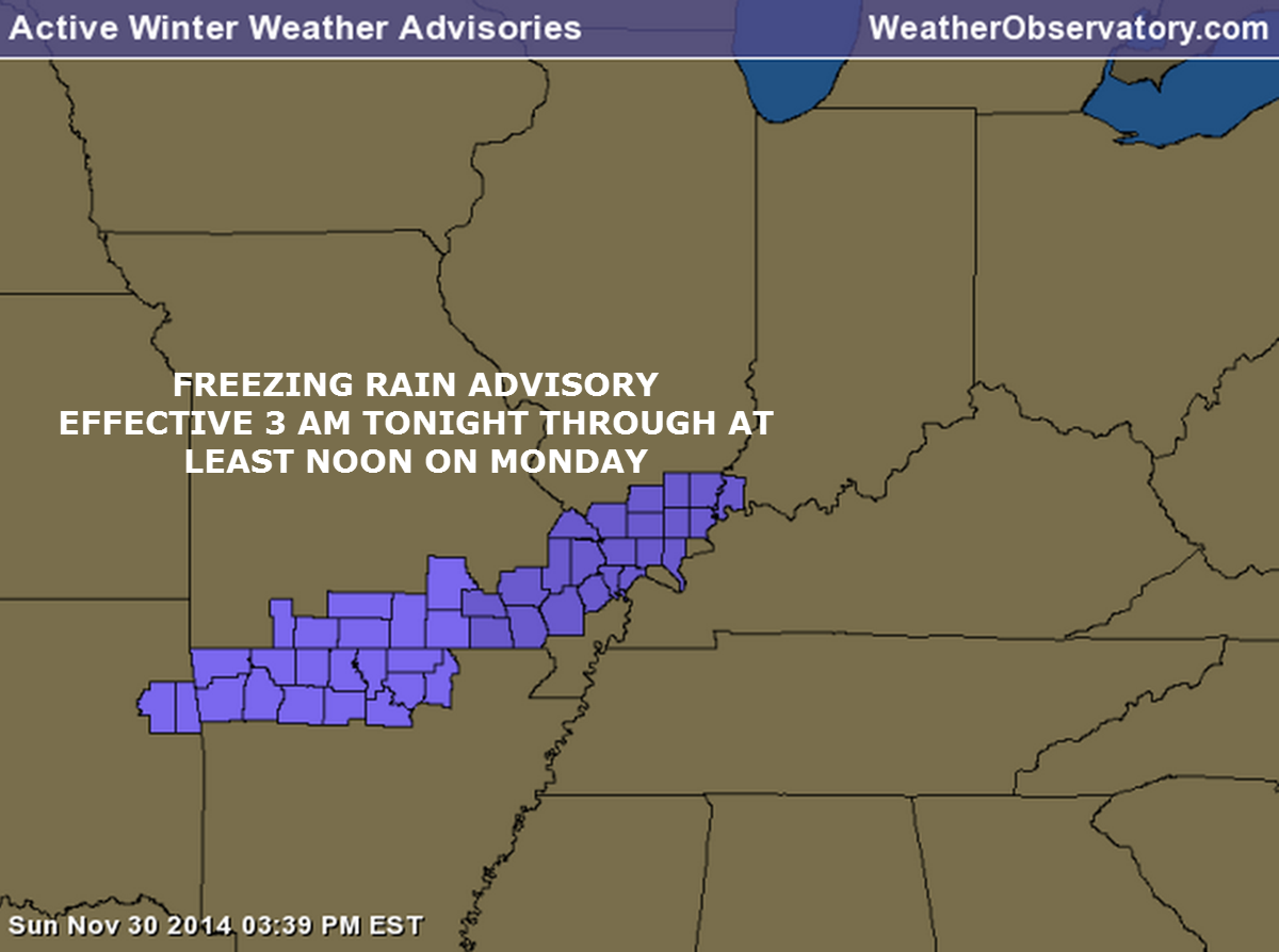
A freezing rain advisory is being issued from 3 am tonight through 12 pm tomorrow. Additional counties may needed to be added tomorrow – an extension may also be necessary.
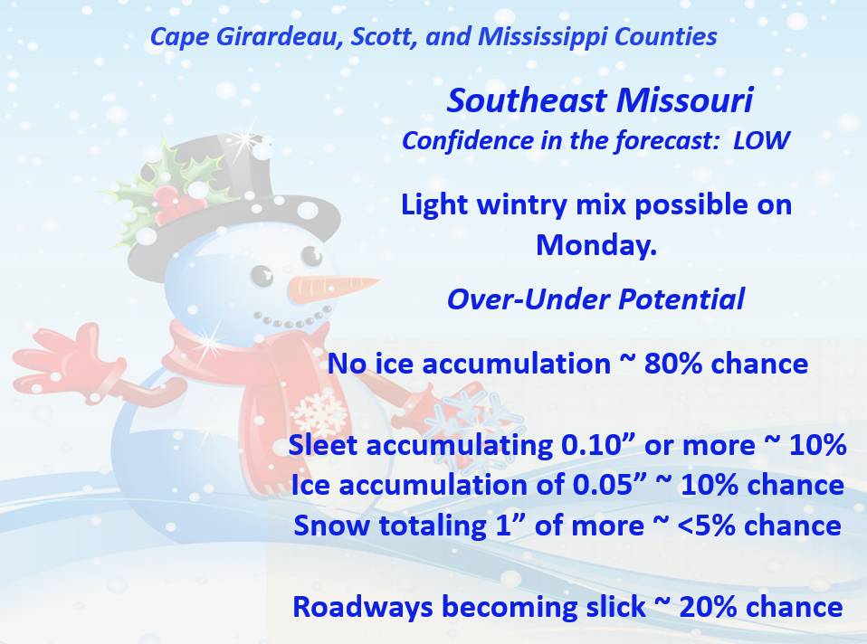
Outline of the advisory
10 AM Blog Update…posted from my Facebook weather page.
November 30, 2014: 10 AM Weather Update…
Most of the morning data is in. Not a lot of changes concerning Monday’s light rain, light freezing rain/drizzle potential.
Very tough call on temperatures for areas along a line from Poplar Bluff to Vienna, Illinois to Evansville, IN. It is possible that north of that line temperatures will be in the 28 to 34 degree range much of the day. The 20′s would be more likely in the hills of the Missouri Ozarks.
There are hints in the data that temperatures might rise 1 to 3 degrees between 11 am and 3 pm (in all areas).
Areas south of a line from Poplar Bluff to Vienna, Illinois to Evansville, might end up in the 32 to 35 degree range for much of the day. Again, if temps are 1-3 degrees colder than forecast then there would be issues. Monitor updates.
The data is mixed on the EXACT temperature. There is very little wiggle room for error. If the temperature ends up just a few degrees colder than forecast then there might be some issues with icing on bridges and overpasses. This would especially be true in areas that dip into the 28, 29, 30 degree range. I am splitting hairs on the temperature forecast. But, splitting hairs is sometimes enough to cause problems.
Sometimes a forecaster just has to say that he isn’t sure. That means a lower than normal confidence level. This is especially true when you are talking about a very small range in temperatures.
The good news…
Roads are starting off quite warm. Today’s mild weather does help that cause.
The precipitation event should be on the light side.
Also…
Areas south of a line from Malden, MO east/northeast to Princeton, KY should remain above freezing through early tomorrow afternoon. Will have to monitor those areas after 3 pm.
The Missouri Ozarks will likely be cold enough for freezing rain and perhaps a little sleet. The good news is that the precipitation should be on the light side. Of course, I always remind people that only a hint of freezing rain or freezing drizzle can cause problems.
Bridges and overpasses will freeze first – decks and porches, as well. Just use care, as always, when taking that first step. Don’t want any broken bones from a hint of ice on your sidewalks or porch/deck.
Temperatures will fall a few degrees on Monday night. If precipitation continues to fall (and with the loss of daylight) then some patchy black ice would be possible. Black ice is simply moisture that remains on roadways after an event is over or nearly over – that moisture then freezes. This could cause a few patchy slick spots.
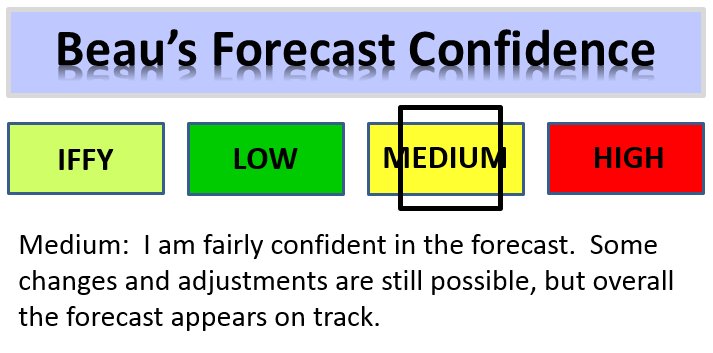
Overall, the forecast is pretty much on track. LOW confidence on just how temperatures play out. When you are talking about 31 vs 33 or 34 degrees – well, that is tricky.
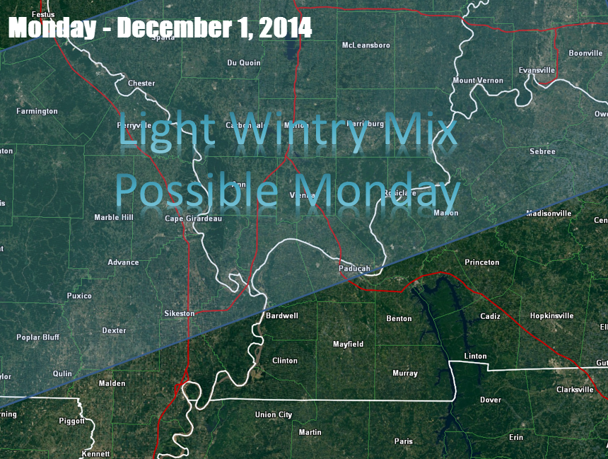

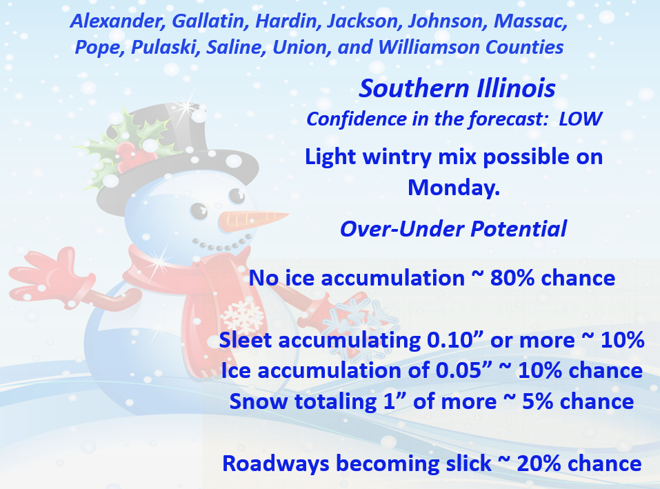
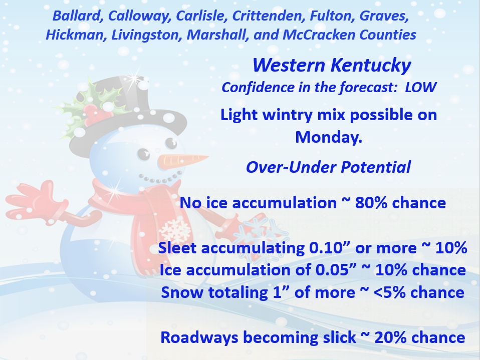
This forecast update covers far southern Illinois, far southeast Missouri, and far western Kentucky. See the coverage map on the right side of the blog.
If you find value in this page and the other weather products on the Weather Observatory web-site then consider making a donation to keep everything up and running. It does cost quite a bit of money each month to run the radars, data feeds, hosting of sites, and more. You can give by visiting our donation page.
Sunday – Mostly cloudy sky conditions. A chance for patchy drizzle or showers. Windy at times. High temperatures into the 60’s! Southwest winds at 10-25 mph.
Sunday night – Cloudy with a chance for showers. Turning colder late. Temperatures falling into the 30’s by morning. Southwest winds becoming northwest at 10-20 mph.
Monday – Lower than normal confidence in how the Monday weather unfolds. Cloudy. A chance for rain early in the morning. Rain changing to a mixture of rain, freezing rain, and sleet during the late morning or early afternoon hours. Freezing rain possible earlier in the morning along a line from Piedmont, MO to McLeansboro, IL. High temperatures holding steady or slowly falling in the 30’s. Northwest winds at 10-15 mph.
Morning School Bus Stop Weather – Cloudy and chilly. Light rain possible. Temperatures will be in the middle or upper 30’s.
Afternoon School Bus Stop Weather – Cloudy and cold. A chance for a wintry mix. Temperatures in the lower to middle 30’s.
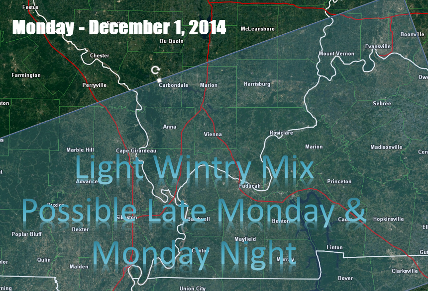
Monday night – Mostly cloudy. A chance for light freezing rain or sleet early in the evening. Perhaps remaining rain near the KY/TN border. Low temperatures in the upper 20’s or lower 30’s. Northeast winds at 15 mph.
Tuesday – Mostly cloudy with a chance for patchy light rain. High temperatures in the lower 40’s. South/southeast winds at 10 mph.

An explanation of what is happening in the atmosphere over the coming days.
Highlights…
1. Much colder tonight into Monday
2. A chance for some light wintry mix on Monday (low confidence on that part of the forecast)
3. Impacts from Monday’s wintry mix should be minimal. The road temperatures are quite warm. This is one part of the forecast that remains at a lower than normal confidence levels.
Good morning! The warmer air has moved into the region. The winds have picked up. Scattered patchy light drizzle and showers have formed. All right on schedule.
The strong cold front that I have been talking about the last few days will stumble into our region later tonight. Behind this cold front temperatures will fall a good 20-30 degrees. High temperatures today will be in the 60’s. High temperatures on Monday will be in the 30’s.
The BIG question that remains in the forecast is whether or not we will experience a period of light freezing rain and sleet on Monday morning into Monday night.
The timing of the cold air will be key to the develop of the wintry mix. If the cold air moves in faster than expected then so will the wintry mix. If the cold air slows down then only the northern portions of our region can expect any issues with freezing precipitation.
Right now it appears that the 32 degree line will push into the northern parts of southeast Missouri and southern Illinois later tonight (perhaps after 1 or 2 am). The freezing line will then sag southward into the wee hours of the morning.
Whether the freezing line can reach the Ohio River by late morning or early afternoon is questionable. Some of the latest data attempts to warm far southern Illinois and western Kentucky into the middle 30’s by late morning and early afternoon.
If we do warm into the middle 30’s then obviously any freezing rain or sleet concern would be minimized.
For there to be widespread travel issues then we would need to see temperatures fall into the upper 20’s. If temperatures remain around 32 degrees then roadways might fair quite well. Bridges and overpasses could be a concern in some areas. Monitor updates.
There remain a lot of questions about Monday’s forecast.
On top of that, I am not overly confident that the wintry mix will cause travel problems on Monday.
1. Ground temperatures are warm
2. Road surfaces will be quite warm early on. It will take longer for the roads to cool down. Bridges and overpasses, of course, will be the first to cool.
3. The coldest air will likely not arrive until after precipitation leaves the region.
4. There remain questions as to just how far south the cold air will push.
Monitor updates – I am hoping to have a better handle on the placement of the 32 degree line by later this afternoon. I will probably come back and update the blog at that time. Perhaps just editing this post.
If any moisture remains on the roadways Monday night then we could see some black ice develop by late Monday night into Tuesday morning.
What is black ice? Good question!
Black ice is simply water that is leftover on the roadways from precipitation that fell below temperatures fell below 32 degrees. Moisture then freezes on the roadways as the temperatures fall below freezing.
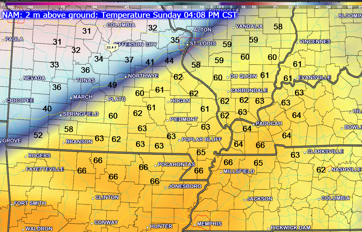
Let’s take a quick look at what the NAM Model is forecasting for temperatures late Sunday night into Tuesday morning. You can see how temperatures will be warm today and then fall quickly tonight.
First graphic is for the 4 pm time frame (this afternoon) – check out those 60 degree+ readings! Now look back to the St Louis area. Cold air is already moving into eastern Missouri. That is a 30 degree temperature drop between western Kentucky and St Louis.
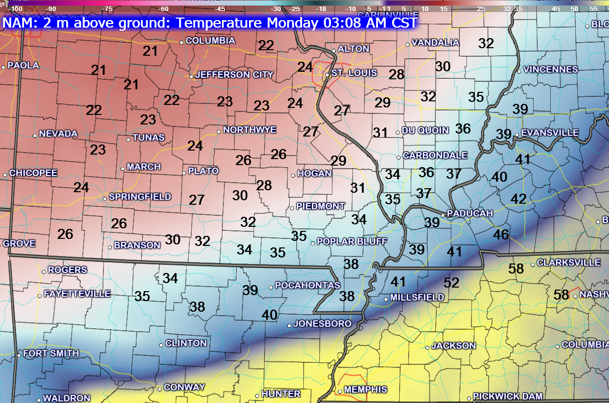
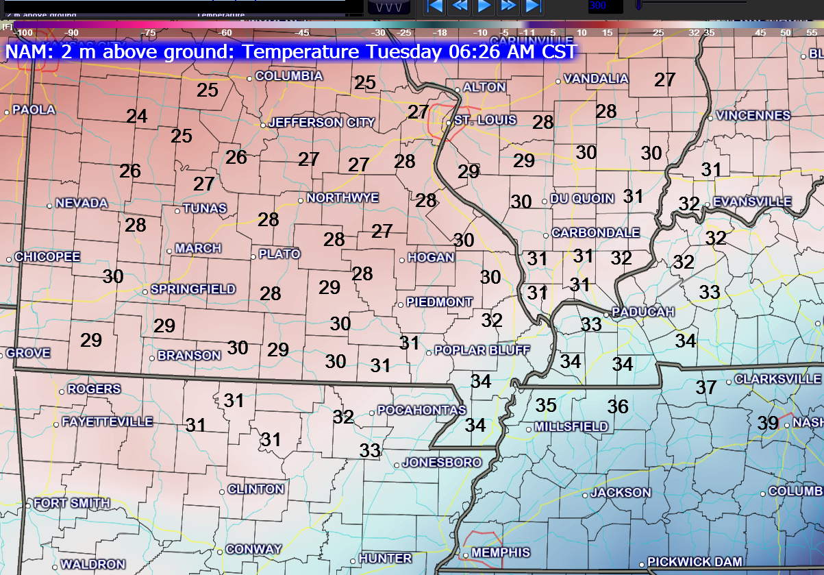
This next image is for the 3 am time frame – Monday morning. Temperatures have fallen into the middle 20’s near St Louis.
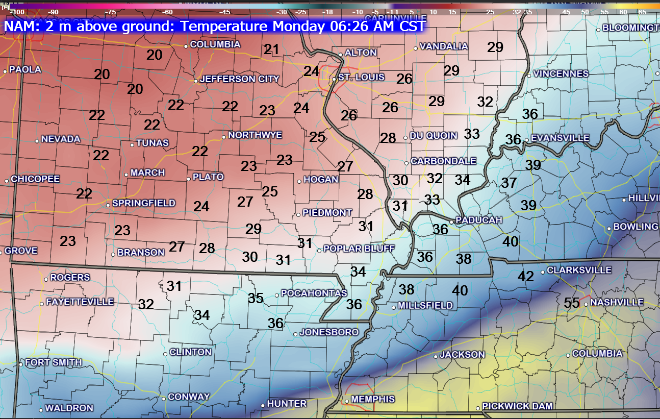
This next image is for 6 am on Monday morning. You can see where the 32 degree line has settled. Keep in mind that just because temperatures have fallen into the lower 30’s does not mean that precipitation will be falling in those locations. As the colder air filters into the region we will also see the atmosphere dry out a bit.
Tricky forecast.
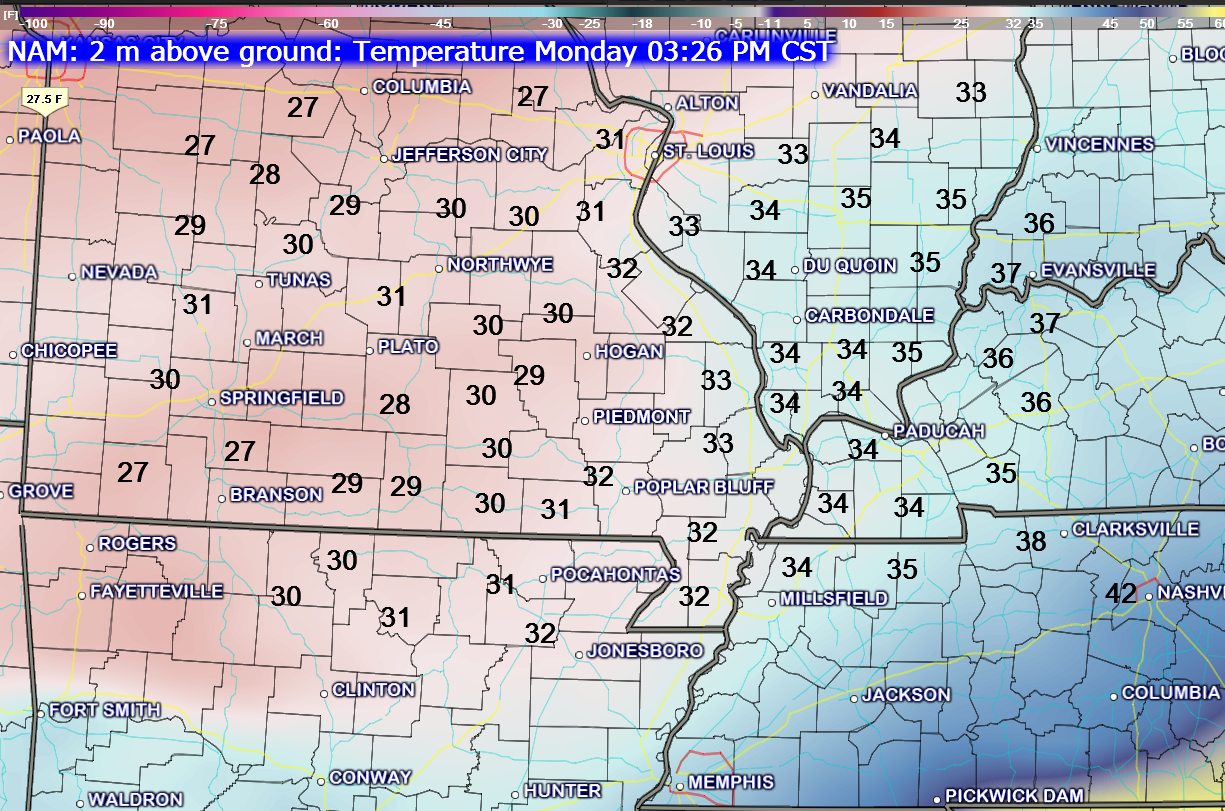
Now let’s look at Monday afternoon – 4 pm. You can see that, according to the NAM model, temperatures have risen a few degrees.
This last image is for Tuesday morning. You can see that temperatures have held steady or fallen a few degrees. The good news is that it does not appear temperatures will fall into the middle 20’s.

I am having a difficult time resolving how Monday turns out. A lot of questions about the placement of the 32° line for Monday morning. Questions remain about whether temperatures will rise a bit during the late morning hours before falling again in the afternoon.
For now, I have left the wording pretty much the same. No real commitment on impact of any freezing precipitation that falls. In other words – roadways may be too warm for it to become a travel issue.
Monitor updates – I suspect there will be additional changes and adjustments. Best I can do right now on this one.

Concerned about temperatures falling on Monday while we still have precipitation in the area. I am also concerned that moisture left on the road Monday night could freeze as temperatures fall into the 20’s.

The Wild Card gives you an idea of what might change that would cause the forecast to not verify.
Wild card in this forecast – It is an obvious one this time around! The possibility of freezing precipitation is the wild card.

Can we expect severe thunderstorms over the next 24 to 48 hours? Remember that a severe thunderstorm is defined as a thunderstorm that produces 58 mph winds or higher, quarter size hail or larger, and/or a tornado.
Thunderstorm threat level is ZERO


Will I need to take action?
Some showers today mean umbrella weather. Will be watching Monday for rain perhaps changing to a wintry mix.

Please visit your local National Weather Service Office by clicking here. The National Weather Service Office, for our region, is located in Paducah, Kentucky.

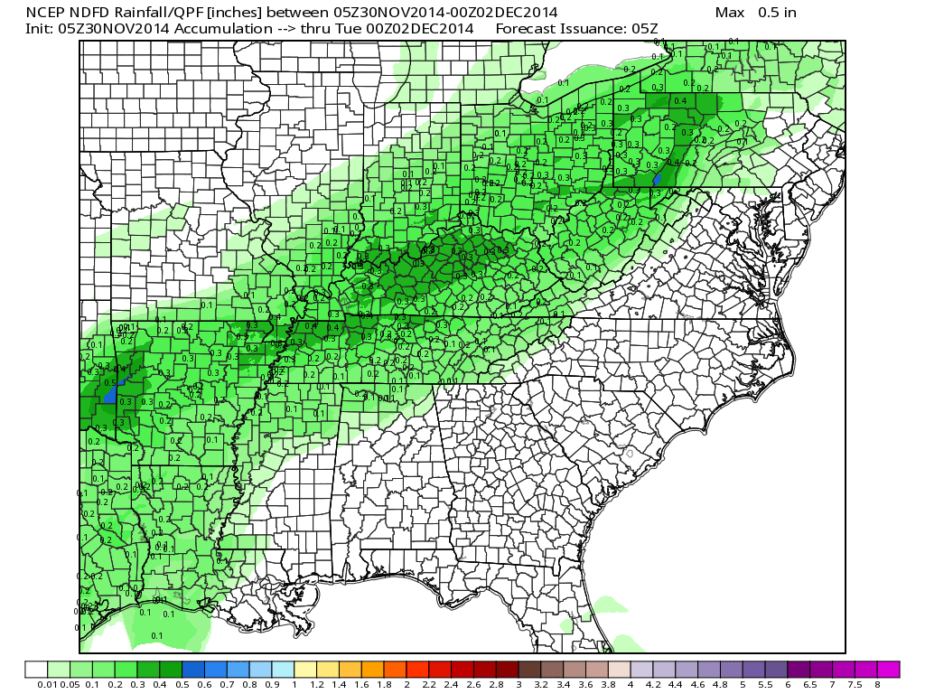
How much rain should this system produce over our region?
Rainfall totals today through Tuesday – you can see totals are not overly impressive. However, some pockets of 0.25″ – 0.30″ are scattered over our region. Widespread 0.05″-0.20″. Again, light event overall.

What to do – what to do…with Monday’s forecast.
At least a chance for a wintry mix on Monday. The impacts from this wintry precipitation may be on the low side. This is because road surfaces will be quite warm during the event. I would be more confident of problems with roadways if temperatures were in the 20’s. With temperatures holding in the lower 30’s this may reduce the concerns for slick roads. As always, bridges and overpasses freeze first.
Check back later today for an update.
My current thoughts on probabilities for the Monday precipitation event

We may see on and off rain chances throughout the upcoming week. Right now it does appear that we won’t have to worry about frozen precipitation (other than perhaps on Monday).
Many of my graphics are from www.weatherbell.com – a great resource for weather data, model data, and more


This blog was inspired by ABC 33/40’s Alabama Weather Blog – view their blog
Current tower cam view from the Weather Observatory- Click here for all cameras.

Southern Illinois Weather Observatory

The Weather Observatory

Southern Illinois Weather Observatory
WSIL TV 3 has a number of tower cameras. Click here for their tower camera page & Illinois Road Conditions

Marion, Illinois
WPSD TV 6 has a number of tower cameras. Click here for their tower camera page & Kentucky Road Conditions & Kentucky Highway and Interstate Cameras

Downtown Paducah, Kentucky
Benton, Kentucky Tower Camera – Click here for full view

Benton, Kentucky

I24 Paducah, Kentucky

I24 Mile Point 9 – Paducah, KY

I24 – Mile Point 3 Paducah, Kentucky

You can sign up for my AWARE email by clicking here I typically send out AWARE emails before severe weather, winter storms, or other active weather situations. I do not email watches or warnings. The emails are a basic “heads up” concerning incoming weather conditions.
If you enjoy this blog and you live down in Alabama then check out the ABC 33/40 Blog. This blog was inspired by their blog.
Alabama Weather Blog


Day 1 Severe Weather Outlook from the Storm Prediction Center – Storm Prediction Center
What does thunderstorms, marginal, slight, enhanced, medium, and high risk mean? Click here

Current Severe thunderstorm and tornado watches from the Storm Prediction Center. The Storm Prediction Center is in charge of issuing watches. Our local National Weather Service Office in Paducah, Kentucky is in charge of issuing warnings.
Remember that a watch means that conditions are favorable for severe weather. Severe weather MIGHT develop over the coming hours. Watches normally last 4 to 8 hours. Monitor updates for possible warnings.
A warning means to take immediate action to protect you and your family. Warnings usually last from 15 to 45 minutes.
For additional watch information click here


Live Lightning Data – zoom and pan: Click here
Live Lightning Data with sound (click the sound button on the left side of the page): Click here
Will I need to take action?
Please visit your local National Weather Service Office by clicking here. The National Weather Service Office, for our region, is located in Paducah, Kentucky.
![]()
We have regional radars and local city radars – if a radar does not seem to be updating then try another one. Occasional browsers need their cache cleared. You may also try restarting your browser. That usually fixes the problem. Occasionally we do have a radar go down. That is why I have duplicates. Thus, if one fails then try another one.
If you have any problems then please send me an email beaudodson@usawx.com
WEATHER RADAR PAGE – Click here —
We also have a new national interactive radar – you can view that radar by clicking here.
Local interactive city radars include St Louis, Mt Vernon, Evansville, Poplar Bluff, Cape Girardeau, Marion, Paducah, Hopkinsville, Memphis, Nashville, Dyersburg, and all of eastern Kentucky – these are interactive radars. Local city radars – click here
NOTE: Occasionally you will see ground clutter on the radar (these are false echoes). Normally they show up close to the radar sites – including Paducah.

Regional Radar – Click on radar to take you our full radar page.


Regional Radar

Current WARNINGS (a warning means take action now). Click on your county to drill down to the latest warning information. Keep in mind that there can be a 2-3 minute delay in the updated warning information.
I strongly encourage you to use a NOAA Weather Radio or warning cell phone app for the most up to date warning information. Nothing is faster than a NOAA weather radio.


Missouri Warnings

Illinois Warnings

Kentucky Warnings
I have added a lot of new maps to the Southern Illinois Weather Observatory web-site. Check them out by clicking here.


The latest 8-14 day temperature and precipitation outlook. Note the dates are at the top of the image. These maps DO NOT tell you how high or low temperatures or precipitation will be. They simply give you the probability as to whether temperatures or precipitation will be above or below normal.


You can sign up for my AWARE email by clicking here I typically send out AWARE emails before severe weather, winter storms, or other active weather situations. I do not email watches or warnings. The emails are a basic “heads up” concerning incoming weather conditions.


