
This forecast update covers far southern Illinois, far southeast Missouri, and far western Kentucky. See the coverage map on the right side of the blog.
If you find value in this page and the other weather products on the Weather Observatory web-site then consider making a donation to keep everything up and running. It does cost quite a bit of money each month to run the radars, data feeds, hosting of sites, and more. You can give by visiting our donation page.
Friday – A mix of sun and clouds. Colder than normal for the Month of November. High temperatures will only be in the upper 40’s. South winds at 10-15 mph.
Friday Night – Becoming cloudy. Not as cold as recent nights. Low temperatures in the upper 30’s and lower 40’s. Winds will pick up from the south at 10-15 mph.
Saturday – Cloudy with patchy light rain or some drizzle. Windy at times. High temperatures will rise into the 50’s. South winds at 10-20 mph.
Saturday night – Cloudy with patchy light rain or drizzle. Temperatures won’t fall much and could actually rise a bit during the night. Lows in the 50’s. South/southwest winds at 10-15 mph.
Sunday – Cloudy and milder. A chance for some light rain showers. High temperatures in the 60’s. Southwest winds at 10-20 mph.
Morning Temperatures


An explanation of what is happening in the atmosphere over the coming days.
We have some interesting weather ahead of us.
Overview…
1. Milder weekend, but with some patchy light rain
2. Strong cold front arrives Sunday night and Monday
3. Light wintry mix possible on Monday (right now this doesn’t appear to be a significant event – but something to monitor)
I felt like an educational post today. The focus will be on layers of the atmosphere and forecasting what type of precipitation might fall during the winter months. We do have a light precipitation event for the weekend. Let’s get right to it!
You will sometimes hear meteorologists talk about “the flow aloft” – what does this mean?
The flow aloft is a reference to the jet stream. Where is the jet stream “flowing” Are the winds aloft flowing in (moving into an area) from the northwest? Are they moving into the area from the west? Are they moving into the area from the south?
If it is late fall or winter and the jet stream is diving in from the northwest then what type of temperatures do you suppose we will have? Right, cold. If the flow is from the west or southwest then what types of temperatures would we have? Typically milder.
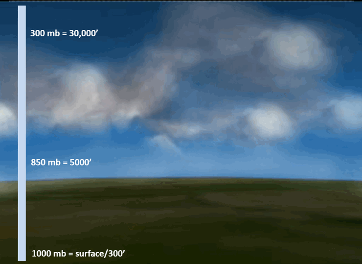
There are different levels to the atmosphere. Meteorologists talk about these levels in millibars. The 1000 mb map would be the surface map (or near surface). What is happening here on the ground. The 850 mb map would be about 5000 feet aloft. The 300 mb map would be about 30,000 feet aloft (the 300 mb level would be where the jet stream is located).
So, again – imagine the atmosphere divided up in sections. Each section is like a layer.
Here is a graphic example of the layers
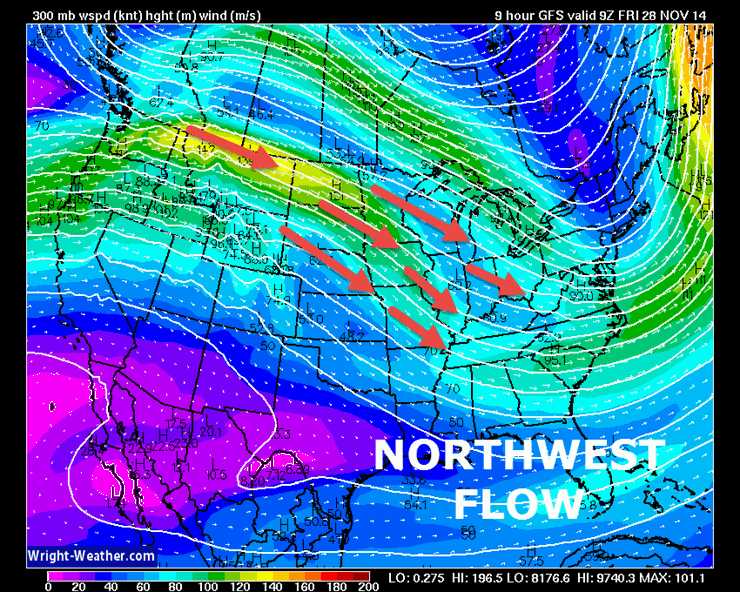
For the most part November was brought a persistent northwest flow pattern. What does that mean? The upper level winds have been from the northwest. This has brought day after day of below normal temperatures. Cold air coming in from Canada. Northwest flow – winds are coming in from the northwest. Thus, the colder weather.
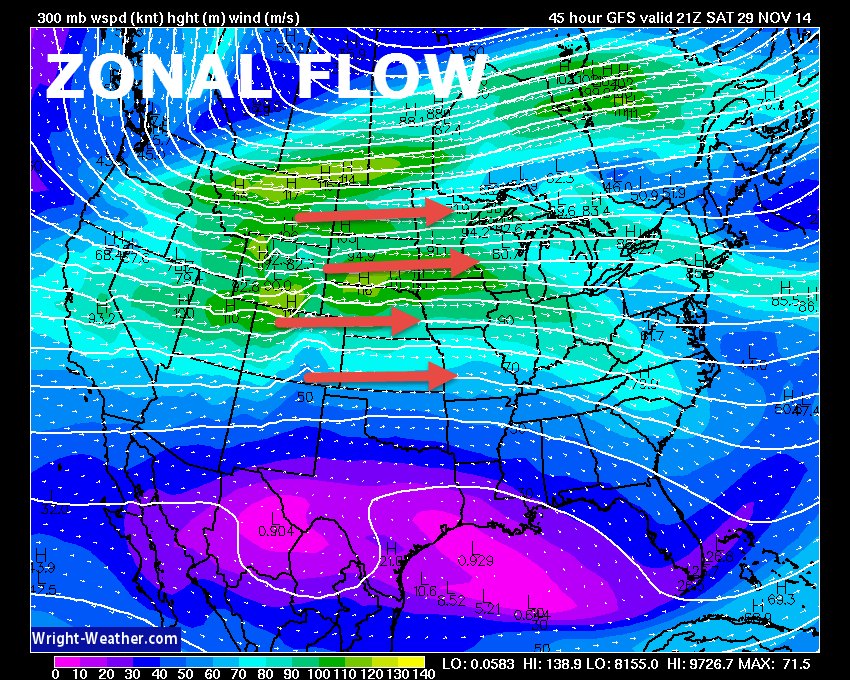
Over the next 72 hours we will see the jet stream and winds become what meteorologist call zonal. That means the jet stream winds will flow from west to east. Remember that a northwest flow could bring colder than normal temperatures. A southerly flow could bring warmer than normal temperatures. A zonal flow is usually in-between.
Let me show you a graphic – this is the wind speeds at the 300 mb level (That would be about 30,000 feet aloft). The jet stream.
This map is showing a northwest flow (the jet stream is diving in from the northwest). This is the Friday morning map. Thus, we are colder than normal.
Now, this is a zonal flow. See how the jet stream is no longer diving in from the northwest? This is the Saturday afternoon map (below)
Thus, on Saturday we will see temperature moderate a bit. Highs on Saturday should reach into the 50’s.
Normally when we see temperatures warm up in the late fall and winter months it also means clouds and light precipitation. That will be the case this weekend. Clouds will thicken and there will be light rain and drizzle chances. It won’t rain all the time on Saturday or Sunday, but there will be patchy light rain scattered over the area.
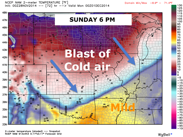
A SHARP cold front arrives on Sunday night and Monday. There will be a dramatic temperature spread across this front. I know you want to see some more graphics. So, here you go!
This is the Sunday night (6 pm) temperature map. See the milder air over our region. Temperatures in the 50’s and 60’s? Possibly so! Those orange and yellow colors are mild temperatures. But, look to the north. That is a sharp sharp cold front ushering in colder temperatures. There is a 30-40 degree temperature difference from northern Missouri to southeast Missouri.
Now THAT is a cold front!
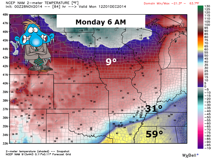
Let’s keep tracking the cold air. The next map is for 6 am on Monday morning. Yes, that is 9 degrees in central Iowa! Temperatures in western Kentucky have fallen into the 30’s. We temporarily say goodbye to our mild weekend temperatures.
Don’t panic – we are not going to see 9° here locally!
Let me zoom in a bit for you. Can you find the cold front? If you can’t find the cold front then you might want to invest in a pair of better glasses.
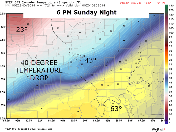
Here is the 6 pm Sunday night temperature forecast map. That is one amazing temperature difference across Missouri and Illinois. A 40 degree temperature spread across the cold front.
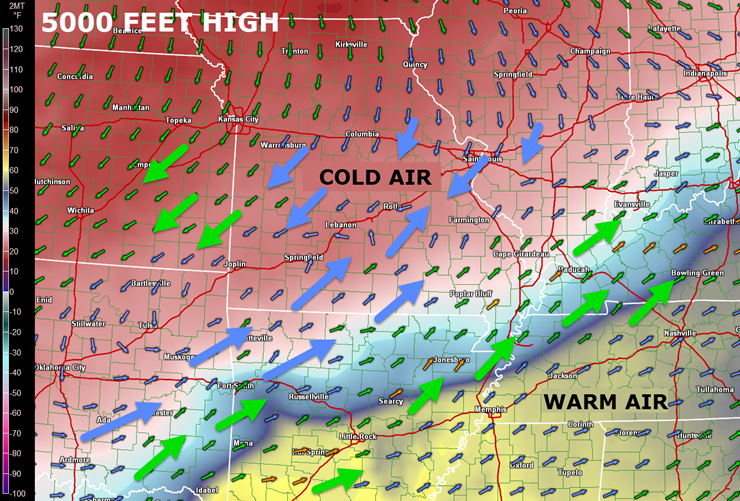
The next question is precipitation. I already told you that there will be some light rain and drizzle around on Saturday and Sunday. That is in response to the warm/moist air moving into the region ahead of the cold front. As temperatures fall on Sunday night and Monday we are going to see the warm air at the 850mb level (5000′ aloft) continue to flow into the region. This is going to flow over the colder temperatures at the surface. When warm/moist air aloft flows over cold air at the surface it can spell a wintry mix of precipitation.
Let me show you a map that has the temperatures at the surface (the base colors on the map – the shades of pink, blue, yellow, orange) and the winds aloft at 5000 feet. The winds aloft are represented by the arrows. See how the arrows are moving northward from the Gulf of Mexico? That represents warm air flowing over the cold air at the surface. If you go far enough north you can see that the arrows are pointing southward. Those areas represent where winds at 5000 feet are flowing southward. Where the winds are flowing southward everything is drying out. My concern is the warm air flowing northward over the cold air at the surface.
What we are concerned about on this map would be where the winds at 5000′ are flowing up and over the cold air at the surface. When this happens you end up with a wintry mix of precipitation. The temperature scale is on the left side of the image.
The difference between the blue arrow and the green arrow is the wind speed. The blue arrow is lighter wind speed than the green arrow.
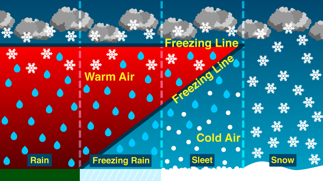
How do we decide whether precipitation will be rain, freezing rain, sleet, or snow? That depends on how thick the warm layer aloft is. To have all snow you want the atmospheric column to be entirely (or almost entirely) below freezing. That way your snow flakes can fall through the clouds and all the way to the ground without melting.
If there is a warm layer aloft then your snow flake is going to melt. Depending on whether there is then a cold layer below the warm layer will determine if that drop of melted snow (water) would freeze into a pellet of ice. That pellet of ice would be sleet.
If the warm layer is thick enough and there is a shallow layer of cold air at the surface (below 32 degree air) then it becomes freezing rain. Freezing rain is not just a cold rain. Freezing rain is rain that freezes when it touches trees, power lines, and other surfaces.
Don’t freak out at this part of the weather lesson! Here is a graphic I found online to illustrate the process
Imagine that this is the atmospheric column. You have the ground at the bottom of the graphic. Then you work you way upward – higher and higher into the atmosphere. Pretend you are an airplane – going higher and higher aloft.
All the way to the right side of this image you see snow is falling! That means your snowflake has no worries about melting. The atmospheric column is entirely below freezing. Team snow likes this type of atmosphere! Now look all the way to the left. Your snowflake falls from the cloud and immediately hits warm air. That warm air extends all the way to the ground. Your snowflake has no chance of survival. Thus, it rains. A kids worst nightmare (well kids who love snow). Now, in-between there is a WHOLE lot of options.
If the warm air aloft is shallow and temperatures quickly drop below freezing below that nudge of warm air then you end up with sleet. But, if temperatures are warm enough throughout a deeper layer of the atmosphere and then surface temperatures are below freezing – you end up with freezing rain.
Complicated? How do you think the weatherman feels! VERY tricky forecasting precipitation type during the winter months. Our region typically falls somewhere on the rain, ice, and snow line. This is why winter forecasting can be such a pain. You have to know exactly what is going on aloft in order to make an accurate forecast. Also remember that the atmosphere is constantly changing. During a typical winter storm you can experience all types of precipitation.
Remember that 850 mb map I showed you above – the one with the wind arrows and the surface temperatures? That 850 mb map shows you the winds at 5000′ above the earths surface. They are blowing in warmer air aloft. Thus, we know on Monday morning that forecasting precipitation type is going to be an issue.

It does appear that rain/drizzle will change to freezing rain, sleet, and snow on Monday morning over portions of our region. There remain some questions on the following
1. How fast will temperatures fall on Sunday night and Monday – how far south will the cold air ooze.
2. How much moisture will be produced by this overrunning event (we call it overrunning because the warm air aloft is running over top the cold air at the surface). It does appear that whatever falls will be light!
3. Will temperatures recover at all on Monday or will they continue to fall through the day as the shallow cold air oozes southward.
At this time it appears that some light wintry mix is likely going to occur in the region late Sunday night into Monday morning. Since temperatures will be somewhat warmer over the weekend this might help keep roads from becoming too much of a problem. However, if both temperatures and precipitation continue to fall on Monday morning then there might be some issues. As always, bridges and overpasses will freeze first.
I always remind people that it does not take a lot of wintry precipitation to cause problems.
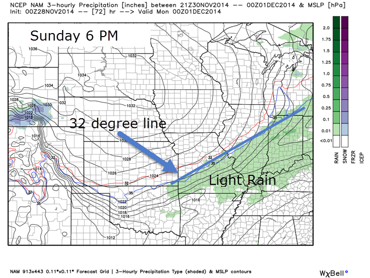
Here are a few model maps showing the potential for precipitation over the weekend and into Monday
This is the 6 pm map on Sunday. You can see the green colors over our area. That represents rain, light rain, and drizzle. The thick blue line represents where temperatures are 32 degrees or below
Here is the same map for 6 am on Monday morning. The purple, red, and orange colors represent a wintry mix of precipitation. Soundings indicate that sleet or freezing rain might be the main concern (instead of snow). Warm air aloft over cold air at the surface usually produces a wintry mix. If you want snow then you need cold air all the way from the ground upward (remember the graphic above).
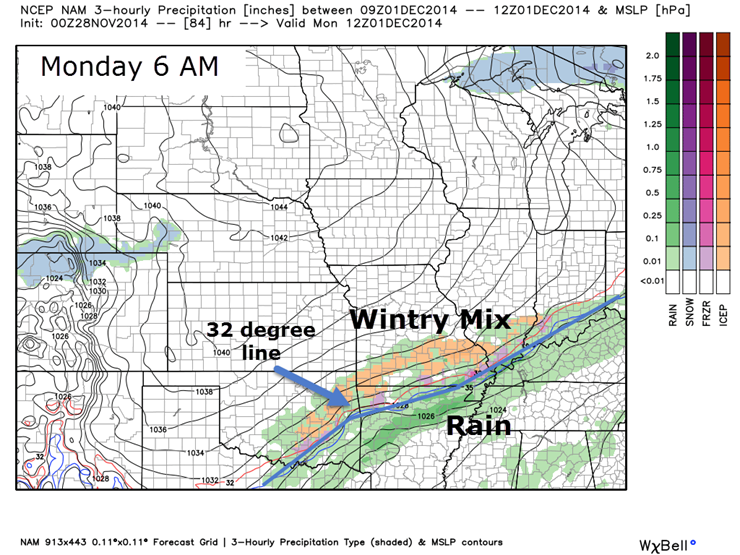
Currently my thinking is that the window of opportunity will be fairly brief on Monday morning for a wintry mix of precipitation. Perhaps a six to eight hour period of time. Temperatures should fall through the day on Monday. There could be some travel issues and those with travel interests should monitor updates as we move forward. We are still 3-4 days out.

I have updated temperatures and wind speeds for the coming days. Increased winds a bit. Starting to monitor the temperatures falls for Sunday night and Monday.

Mostly concerned about a strong cold front on Sunday night and Monday. We might see a wintry mix develop for some of our counties by Monday morning. Stay tuned.

The Wild Card gives you an idea of what might change that would cause the forecast to bust. A busted forecast means a forecast that does not verify. For example, if a winter storm (the area of low pressure) shifts its track 50 miles further south than expected, then that could cause a dramatic change in how much snow might or might not accumulate.
Wild card in this forecast – the wild card for the short term forecast will be precipitation chances on Saturday and Sunday. It appears at least a chance for some light rain and drizzle from time to time. Some spots may remain dry.

Can we expect severe thunderstorms over the next 24 to 48 hours? Remember that a severe thunderstorm is defined as a thunderstorm that produces 58 mph winds or higher, quarter size hail or larger, and/or a tornado.
Thunderstorm threat level is zero! No severe weather concerns through Tuesday.


Will I need to take action?
Some on and off light rain and drizzle this weekend. Perhaps keep the umbrella around. Does not appear to be a big deal.

Please visit your local National Weather Service Office by clicking here. The National Weather Service Office, for our region, is located in Paducah, Kentucky.

How much rain should this system produce over our region?
Rainfall totals for Saturday and Sunday should only be in the trace range (less than 0.10″)

A chance for a wintry mix on Monday morning. This will need to be closely monitored as cold air advances into the region. The wintry mix may last into Monday afternoon. Still a lot of questions on how much precipitation will occur. Monitor updates.

I spent most of the focus on the short term forecast. We will have a bit of a roller-coaster ride in the temperature department this week. We should see temperatures warm a bit on Wednesday or Thursday of next week. Temperatures may then fall again with another strong cold from by late next week.
Nature can’t quite make up its mind! The transition of seasons is coming a bit later this year (November must have though it was December).
If you remember a few days ago it appeared that we might have some wet/stormy weather next week (even thunderstorms). There are a lot of questions about whether or not we will see sustained above normal temperatures next week. It appears we will see some brief warmups and then more cold air arrives. The data is inconsistent in how next week unfolds.
There are hints of a bigger/more organized storm system towards the end of next week. But, that is a long way off and I don’t have any confidence (at this point) in whether that will happen.
It does appear that we will have quite a few swings in the temperature department. If nothing else.
Many of my graphics are from www.weatherbell.com – a great resource for weather data, model data, and more


This blog was inspired by ABC 33/40’s Alabama Weather Blog – view their blog
Current tower cam view from the Weather Observatory- Click here for all cameras.

Southern Illinois Weather Observatory

The Weather Observatory

Southern Illinois Weather Observatory
WSIL TV 3 has a number of tower cameras. Click here for their tower camera page & Illinois Road Conditions

Marion, Illinois
WPSD TV 6 has a number of tower cameras. Click here for their tower camera page & Kentucky Road Conditions & Kentucky Highway and Interstate Cameras

Downtown Paducah, Kentucky
Benton, Kentucky Tower Camera – Click here for full view

Benton, Kentucky

I24 Paducah, Kentucky

I24 Mile Point 9 – Paducah, KY

I24 – Mile Point 3 Paducah, Kentucky

You can sign up for my AWARE email by clicking here I typically send out AWARE emails before severe weather, winter storms, or other active weather situations. I do not email watches or warnings. The emails are a basic “heads up” concerning incoming weather conditions.