We have some great sponsors for the Weather Talk Blog. Please let our sponsors know that you appreciate their support for the Weather Talk Blog.
Milner and Orr Funeral Home and Cremation Services located in Paducah, Kentucky and three other western Kentucky towns – at Milner and Orr they believe in families helping families. You can find Milner and Orr on Facebook, as well.
![]()
.

Wortham Dental Care located in Paducah, Kentucky. The gentle dentist. Mercury free dentistry. They also do safe Mercury removal. You can find Wortham Dental Care on Facebook, as well
.

Visit the eye care associates of Kentucky (the Paducah location) for all of your families eye care needs. Visit their web-site here. Or, you can also visit their Facebook page.
.

Endrizzi’s Storm Shelters – For more information click here. Endrizzi Contracting and Landscaping can be found on Facebook, as well – click here
.

Best at Enabling Body Shop Profitability since 1996. Located In Paducah Kentucky and Evansville Indiana; serving all customers in between. They provide Customer Service, along with all the tools necessary for body shops to remain educated and competitive. Click the logo above for their main web-site. You can find McClintock Preferred Finishes on Facebook, as well
.

Duck/goose decoys? Game calls? Optics? We have you covered! Click the logo above or visit Final Flight on Facebook, as well.

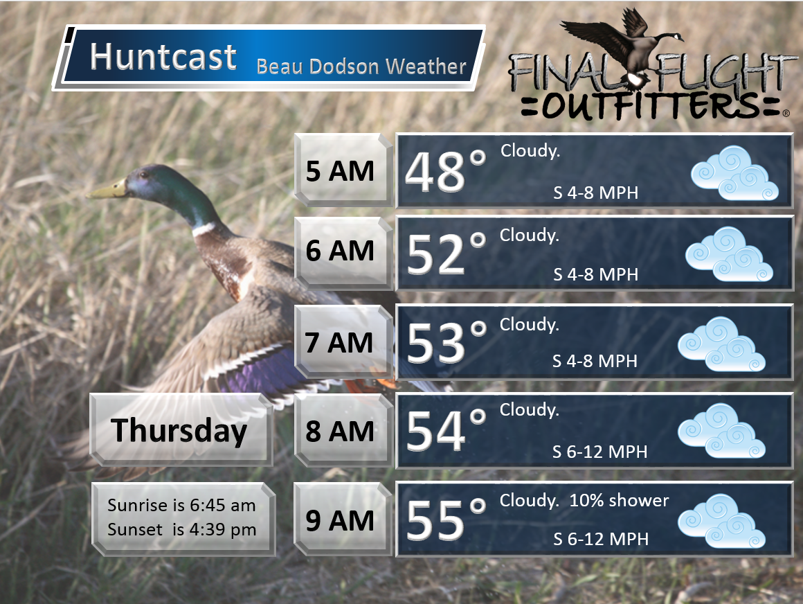
This forecast update covers far southern Illinois, far southeast Missouri, and far western Kentucky. See the coverage map on the right side of the blog.
Remember that weather evolves. Check back frequently for updates, especially during active weather.
Wednesday night – Increasingly cloudy sky conditions. A 10% chance for a light shower or sprinkle.
Temperatures: Lows in the middle to upper 40s
Winds: South winds at 10 mph with gusts to 15 mph
What is the chance for precipitation? 10%
Coverage of precipitation? None
My confidence in this part of the forecast verifying is high
Should I be concerned about snow or ice?
Should I cancel my outdoor plans? No
Is severe weather expected? No
What impact is expected? None
Thanksgiving – Cloudy. A 30% chance for a shower. Better chances over our far western counties of southeast Missouri
Temperatures: Highs ranging from 60 to 66 degrees. Very mild for Thanksgiving.
Winds: South winds at 8 to 16 mph.
What is the chance for precipitation? 30%
Coverage of precipitation? Scattered
My confidence in this part of the forecast verifying is high
Should I be concerned about snow or ice? No
Should I cancel my outdoor plans? No
Is severe weather expected? No
What impact is expected? No real impacts. If a shower forms then obviously some wet roadways.
WEATHER RADAR PAGE – Click here —
Thursday night – Cloudy with rain developing as the night wears on. Better chances the later into the night you go (eastern counties may have to wait until Friday for their precipitation).
Temperatures: Lows ranging from 50 to 55 degrees.
Winds: South winds at 10 mph
What is the chance for precipitation? 60%
Coverage of precipitation? Scattered to perhaps widespread as we move through the overnight hours into Friday morning
My confidence in this part of the forecast verifying is medium
Should I be concerned about snow or ice? No
Should I cancel my outdoor plans? I would monitor updates. Rain appears likely as we move through the overnight hours.
Is severe weather expected? No
What impact is expected? Wet roadways
Friday – Cloudy. Rain likely. Falling temperatures over much of southeast Missouri and southwest Illinois during the afternoon hours.
Temperatures: Highs in the upper 50s to lower 60s and then falling into the 40s over parts of southeast Missouri and southwest Illinois.
Winds: South/southwest winds at 6-12 mph.
What is the chance for precipitation? 90%
Coverage of precipitation? Widespread
My confidence in this part of the forecast verifying is High
Should I be concerned about snow or ice? No
Should I cancel my outdoor plans? Better monitor updates. Rain appears likely.
Is severe weather expected? No
What impact is expected? Wet roadways
Friday night – Cloudy with rain likely. Colder.
Temperatures: Lows in 40s (upper 30s possible over northern parts of southeast Missouri)
Winds: Southwest winds at 10 mph
What is the chance for precipitation? 80%
Coverage of precipitation? Widespread rain expected
My confidence in this part of the forecast verifying is High
Should I be concerned about snow or ice? No
Should I cancel my outdoor plans? Perhaps. Rain is likely in the region.
Is severe weather expected? No
What impact is expected? Wet roadways and possible some flooding issues in isolated spots.
Saturday – Cloudy. Colder for much of the region. Rain likely.
Temperatures: Highs in the upper 40s to lower 50s. Temperatures will vary over the region. Colder behind the front. That could mean parts of western Kentucky and northwest Tennessee remain in the 50s during the morning hours. Temperatures falling into the 40s over western Kentucky by late morning into the early afternoon hours. Again, temps will vary.
Winds: South/southeast winds at 6-12 mph
What is the chance for precipitation? 80%
Coverage of precipitation? Widespread
My confidence in this part of the forecast verifying is Medium
Should I be concerned about snow or ice? No
Should I cancel my outdoor plans? Have a plan B
Is severe weather expected? No
What impact is expected? Wet roadways and possible some flooding issues in isolated spots.
Saturday night – Cloudy with rain likely. Cold rain.
Temperatures: Lows in 40s. Upper 30 possible over parts of southeast Missouri and southwest Illinois. Colder northwest vs southeast in our region.
Winds: Southwest winds at 10 mph
What is the chance for precipitation? 70%
Coverage of precipitation? Widespread rain possible
My confidence in this part of the forecast verifying is Medium
Should I be concerned about snow or ice?
Should I cancel my outdoor plans? Perhaps. Rain is likely in the region.
Is severe weather expected? No
What impact is expected? Wet roadways and possible some flooding issues in isolated spots.
Sunday – Cloudy. Rain possible.
Temperatures: Highs in the middle 40s to lower 50s. Colder northwest counties vs southeast.
Winds: South winds over part of western Kentucky ahead of the cold front. Northwest/west winds behind the cold front.
What is the chance for precipitation? 60%
Coverage of precipitation? Scattered to widespread
My confidence in this part of the forecast verifying is Medium
Should I be concerned about snow or ice? No
Should I cancel my outdoor plans? Perhaps be thinking about a plan B. Monitor updates.
Is severe weather expected? No
What impact is expected? Wet roadways. Some area could have high stream and creek levels.
Sunday night – Cloudy with a chance for showers. Showers should be winding down Sunday night. Some data lingers rain into Monday.
Temperatures: Lows in upper 30s to lower 40s
Winds: Southwest winds at 10 mph
What is the chance for precipitation? 40%
Coverage of precipitation? Showers possible
My confidence in this part of the forecast verifying is Medium
Should I be concerned about snow or ice?
Should I cancel my outdoor plans? No, but monitor updates in case the rain is slow to exit.
Is severe weather expected? No
What impact is expected? Wet roadways.
Monday – Partly cloudy. A chance for some showers.
Temperatures: Highs in the lower 50s Lower confidence on temperature on Monday. We could end up mostly in the 40s.
Winds: West at 6-12 mph
What is the chance for precipitation? 40%
Coverage of precipitation? Isolated/scattered early
My confidence in this part of the forecast verifying is Low/Medium
Should I be concerned about snow or ice? No
Should I cancel my outdoor plans? No, but monitor updates in case rain is slow to exit.
Is severe weather expected? No
What impact is expected? Wet roadways possible.
Click their ad below to visit their web-site or click here reedelec.com


![]()


Don’t forget to check out the Southern Illinois Weather Observatory web-site for weather maps, tower cams, scanner feeds, radars, and much more! Click here

An explanation of what is happening in the atmosphere over the coming days…
Highlights
1. Very nice Thanksgiving. Mild.
2. Rain enters the picture Thursday night into Friday
3. Quite a bit of rain expected. But, will it cause problems?
4. Colder temperatures arrive Friday night into the weekend. High may not get out of the 40 on SAT/SUN. Perhaps a little milder over our southern and southeast counties of west KY
HAPPY THANKSGIVING EVERYONE!!!! I hope you have a splendid holiday weekend. The weather will be nice for Thanksgiving (day). High temperatures will be in the 60s.
But, rain enters the picture late Thursday night into Sunday. A long duration rain event.
The good news is that I don’t anticipate any local travel issues on Wednesday night into Thursday evening. Yes, some wet roadways will be possible late Thursday night, but no snow or ice.
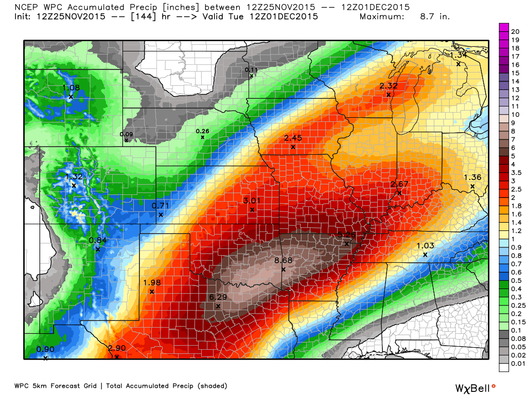
This is going to be a very wet system. Remember the last one? It could be a duplicate of that event. I am forecasting a widespread 1″-3″ rain event. Locally heavy rain will likely mean some pockets of 3″+ totals. Right now, subject to changes, the heaviest rainfall totals will likely be over southeast Missouri and the Missouri Bootheel. Then lesser amounts into southern Illinois, western Kentucky, and northwest Tennessee. I say lesser, but amounts will be impressive over just about the whole region.
WEATHER RADAR PAGE – Click here —
Flood concerns?
We just had a large rain event a week or two ago. The ground is a bit more saturated this time around. The Springfield, St Louis, and Memphis National Weather Service Offices have already issued or will be issuing flash flood and flood watches for some of their counties (each NWS office has certain counties they are responsible for. See the watch/warning map below). Whether the Paducah, Kentucky NWS does or does not issue a watch is up to them, as always.

The good news is that the rain will be over a period of several days. However, some rivers are already out of their banks in the region. This additional rain could cause some problems. Let’s keep an eye on it.
The flash flood threat appears fairly small (since the rain will last several days). The thunderstorm threat appears fairly small. That is also good news. Thunderstorms would only enhance the rainfall totals.
Bottom line is that we will have quite a bit of rain from late Thursday into Sunday. The rain should taper off Sunday night into Monday.
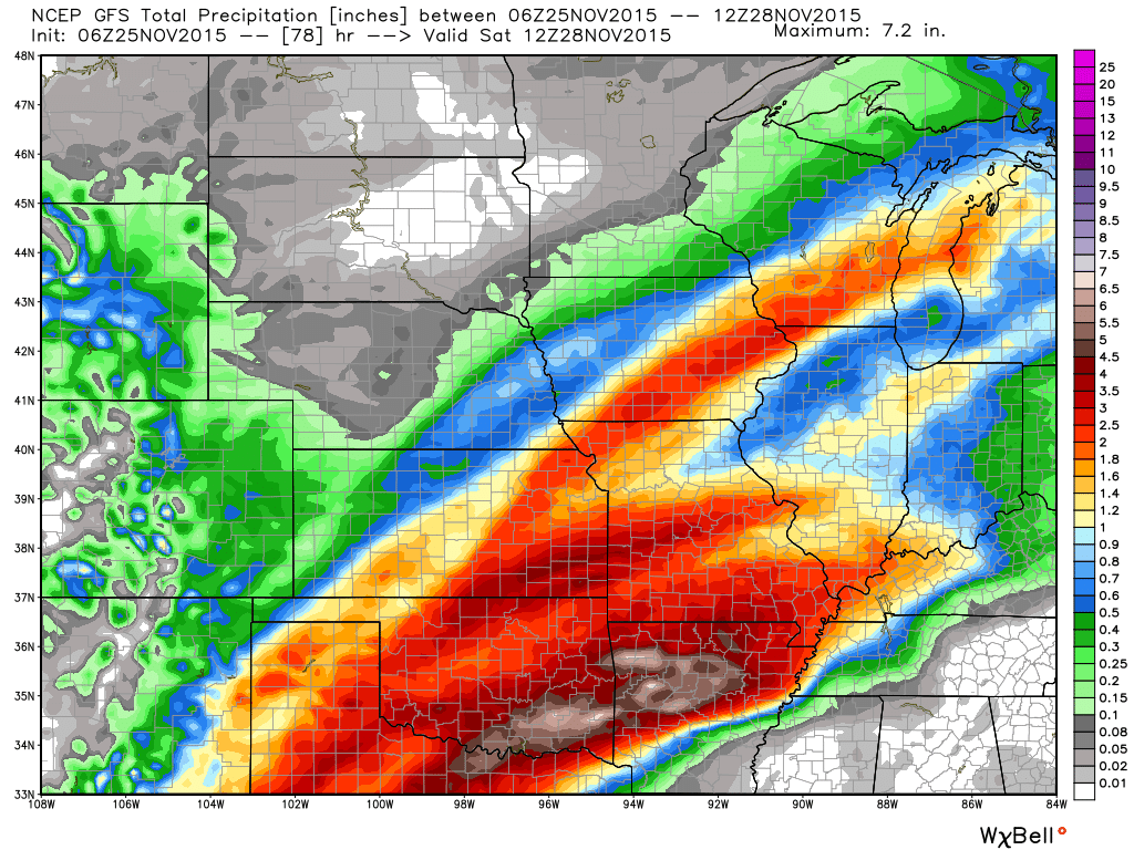
A couple of maps
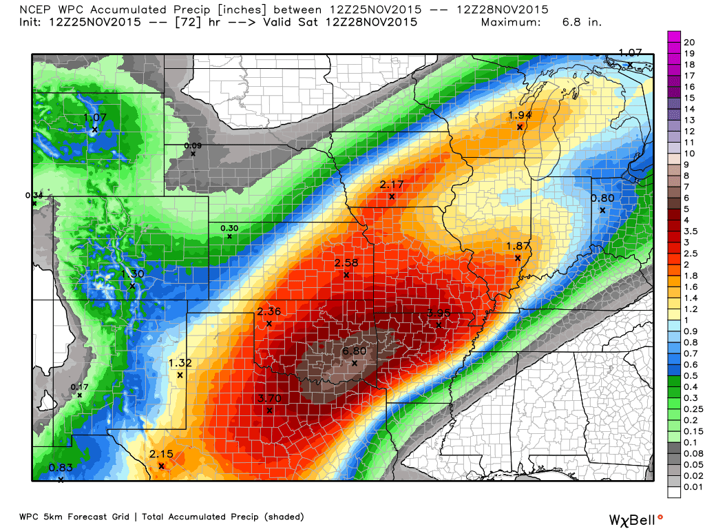
Here is the GFS rainfall map. This is through Saturday morning (keep in mind that more rain falls after this time). The red totals in our region would be 2″-3″. The yellow and orange colors are more along the 1″-2″ line.
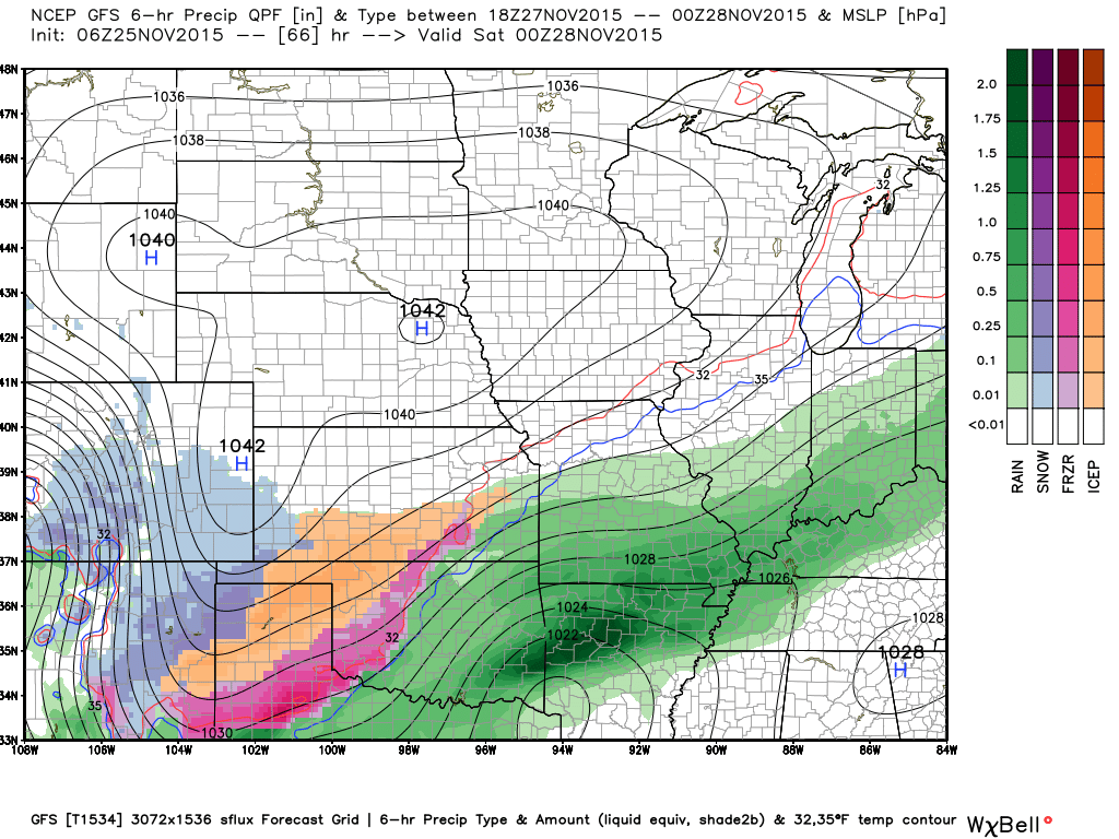
This is the GFS precipitation map for Friday morning. The colors represent the rain that has fallen over the previous six hours.
By Friday morning most of the area should have some showers. It might take a little longer for the rain to reach our eastern counties, keep that in mind. Western counties will have rain earlier.
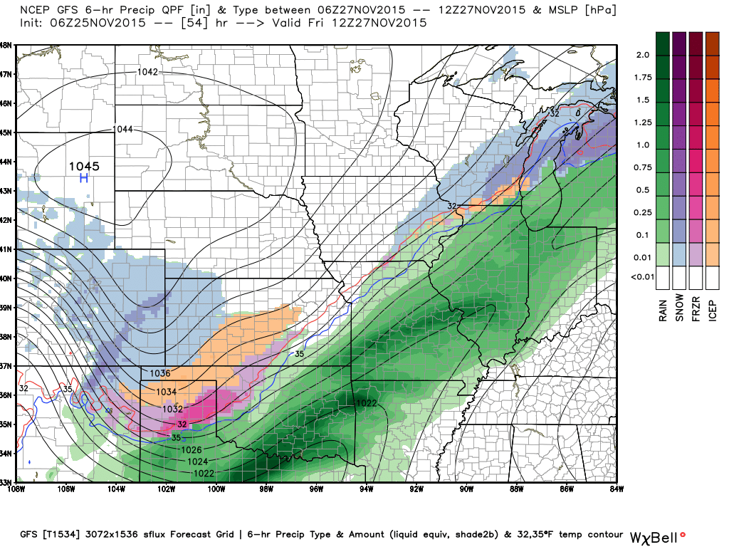
This next map is for Friday evening. Rain continues. Green represents rain. The blue, orange, and purple colors represent frozen precipitation.
This next map is for Sunday morning. Rain continues. Maybe a hint of snow over Iowa and northern Missouri.
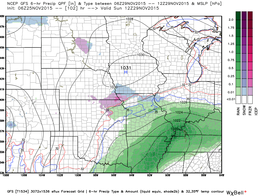

No snow anticipated.

No frozen precipitation through Monday.

Tweaked rain probabilities. Otherwise, no significant changes to the ongoing forecast.

Rain, I suppose is the main concern. Quite a bit of it. Expect widespread 1-3″ from this event. Pockets of greater than 3″.

Umbrella alert 🙂

The wild card in the forecast will be rainfall totals through Sunday/Sunday night. I am anticipating a widespread 1-3″ event. Pockets of greater than 3″ likely.
The second wild card will be when does the rain end. I am leaning towards the rain ending on Sunday night. Some models show showers still in the region on Monday.

No frost or freeze in the forecast

How much precipitation should we expect over the next few days?
Rain will spread over the region on Thursday night into Friday. Rain will likely continue into at least Sunday and Sunday night. Rainfall totals of 1-3″ with pockets of 3″+.
Here is the official NOAA rainfall forecast. Scale is on the right.
This first graphic is through Saturday morning
The second graphic is for the entire event

Can we expect severe thunderstorms over the next 24 to 48 hours? Remember that a severe thunderstorm is defined as a thunderstorm that produces 58 mph winds or higher, quarter size hail or larger, and/or a tornado.
The thunderstorm threat level will be ZERO for Thursday night. Then a ONE for Friday into Sunday (maybe a rumble of thunder). I am not expecting any severe weather.
..
Thursday: Severe weather is not anticipated. Thunder Thursday night?
Friday: Severe weather is not anticipated. Thunder?
Saturday: Severe weather is not anticipated.
Sunday: Severe weather is not anticipated.
Monday: Severe weather is not anticipated.
Tuesday: Severe weather is not anticipated.


We have regional radars and local city radars – if a radar does not seem to be updating then try another one. Occasional browsers need their cache cleared. You may also try restarting your browser. That usually fixes the problem. Occasionally we do have a radar go down. That is why I have duplicates. Thus, if one fails then try another one.
If you have any problems then please send me an email beaudodson@usawx.com
WEATHER RADAR PAGE – Click here —
We also have a new national interactive radar – you can view that radar by clicking here.
Local interactive city radars include St Louis, Mt Vernon, Evansville, Poplar Bluff, Cape Girardeau, Marion, Paducah, Hopkinsville, Memphis, Nashville, Dyersburg, and all of eastern Kentucky – these are interactive radars. Local city radars – click here
NOTE: Occasionally you will see ground clutter on the radar (these are false echoes). Normally they show up close to the radar sites – including Paducah.


Here is the official 6-10 day and 8-14 day temperature and precipitation outlook. Check the date stamp at the top of each image (so you understand the time frame).
The forecast maps below are issued by the Weather Prediction Center (NOAA).


The latest 8-14 day temperature and precipitation outlook. Note the dates are at the top of the image. These maps DO NOT tell you how high or low temperatures or precipitation will be. They simply give you the probability as to whether temperatures or precipitation will be above or below normal.


Here are the current river stage forecasts. You can click your state and then the dot for your location. It will bring up the full forecast and hydrograph.
Click Here For River Stage Forecasts…

Who do you trust for your weather information and who holds them accountable?
I have studied weather in our region since the late 1970’s. I have 37 years of experience in observing our regions weather patterns. My degree is in Broadcast Meteorology from Mississippi State University and an Associate of Science (AS). I am currently working on my Bachelor’s Degree in Geoscience.
My resume includes:
Member of the American Meteorological Society.
NOAA Weather-Ready Nation Ambassador.
Meteorologist for McCracken County Emergency Management.
I own and operate the Southern Illinois Weather Observatory.
Recipient of the Mark Trail Award, WPSD Six Who Make A Difference Award, Kentucky Colonel, and the Caesar J. Fiamma” Award from the American Red Cross.
In 2009 I was presented with the Kentucky Office of Highway Safety Award.
Recognized by the Kentucky House of Representatives for my service to the State of Kentucky leading up to several winter storms and severe weather outbreaks.
I am also President of the Shadow Angel Foundation which serves portions of western Kentucky and southern Illinois.
There is a lot of noise on the internet. A lot of weather maps are posted without explanation. Over time you should learn who to trust for your weather information.
My forecast philosophy is simple and straight forward.
- Communicate in simple terms
- To be as accurate as possible within a reasonable time frame before an event
- Interact with you on Twitter, Facebook, and the blog
- Minimize the “hype” that you might see on television or through other weather sources
- Push you towards utilizing wall-to-wall LOCAL TV coverage during severe weather events
I am a recipient of the Mark Trail Award, WPSD Six Who Make A Difference Award, Kentucky Colonel, and the Caesar J. Fiamma” Award from the American Red Cross. In 2009 I was presented with the Kentucky Office of Highway Safety Award. I was recognized by the Kentucky House of Representatives for my service to the State of Kentucky leading up to several winter storms and severe weather outbreaks.
If you click on the image below you can read the Kentucky House of Representatives Resolution.

Many of my graphics are from www.weatherbell.com – a great resource for weather data, model data, and more


You can sign up for my AWARE email by clicking here I typically send out AWARE emails before severe weather, winter storms, or other active weather situations. I do not email watches or warnings. The emails are a basic “heads up” concerning incoming weather conditions.