Good day, everyone
Winter storm update.
A quick travel forecast update. I know many of you are on the road this weekend.
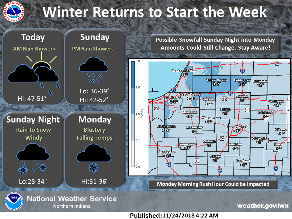
Locally, we will have some rain showers Sunday. Gusty winds, as well. I do not anticipate any travel issues across our local area.
The rain may end as snow flurries or snow showers Sunday night. I do not anticipate any travel issues. Monitor updates, as always.
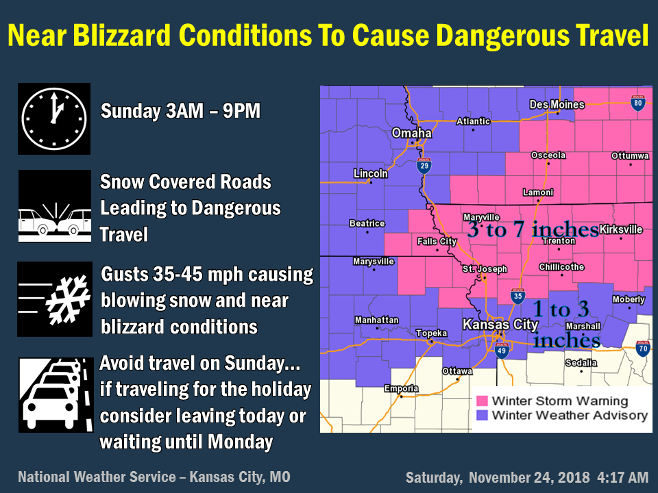
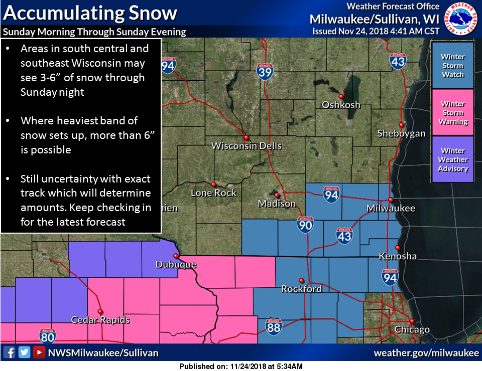
We have a blizzard developing across portions of Iowa, northern Missouri, Wisconsin, and northern Illinois.
There remain differences within the model packages concerning the storm track, but the key features are on the map.
This event will occur. It is just a matter of placement for the highest snow totals and blizzard or near blizzard conditions.
If you have travel plans (well to our north) late Saturday night and Sunday/Sunday night, then you need to monitor the latest winter weather warnings and travel conditions.
This is a high impact event and some roads/interstates may be shut down during the peak of the storm.
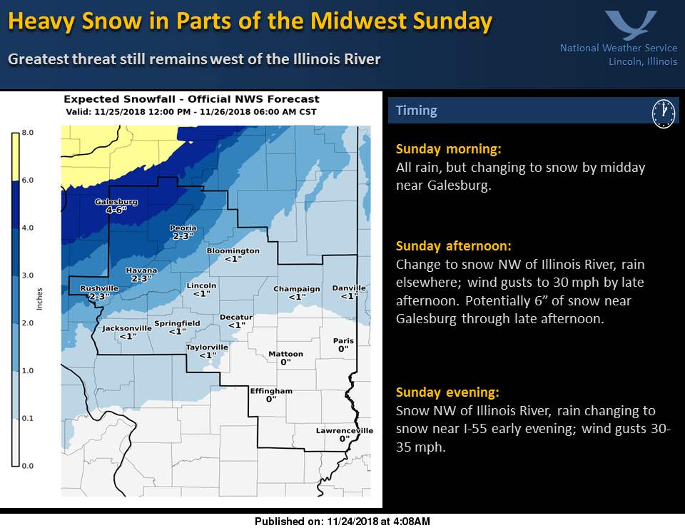
Central Illinois should not be a concern with most of this event. Perhaps ending there as a few snow showers, but nothing like what will happen to the north.
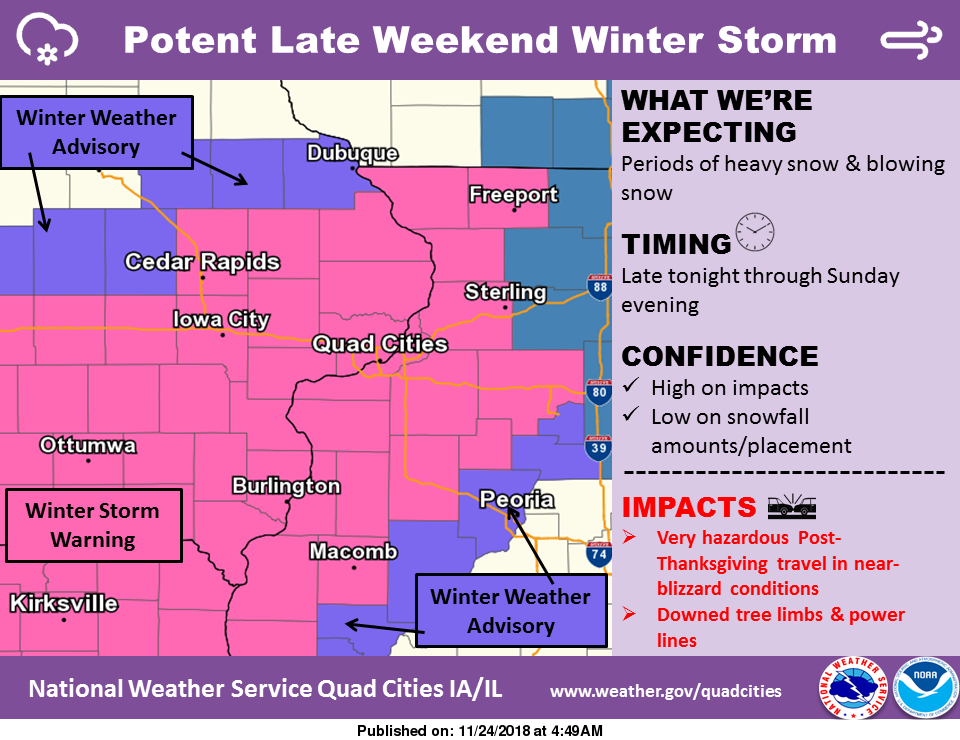
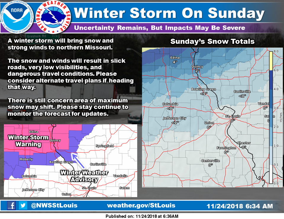
Here are the latest winter weather advisories, winter storm warnings, and winter storm watches.
Winter weather advisories mean that snow will occur with some travel issues. That would be the purple zone.
Winter storm warnings are in pink. That is where heavier snow and wind are expected. Travel impacts will be higher.
The blue area represents winter storm watches. These will likely be upgraded to warnings.
It is possible that the warning zone could also be expanded a row or two counties southward, although this appears like a low risk.
It is also possible that blizzard warnings are issued. This will be highly dependent on wind speeds. Blizzard conditions have to meet a certain criteria. It involves wind speed and visibility.
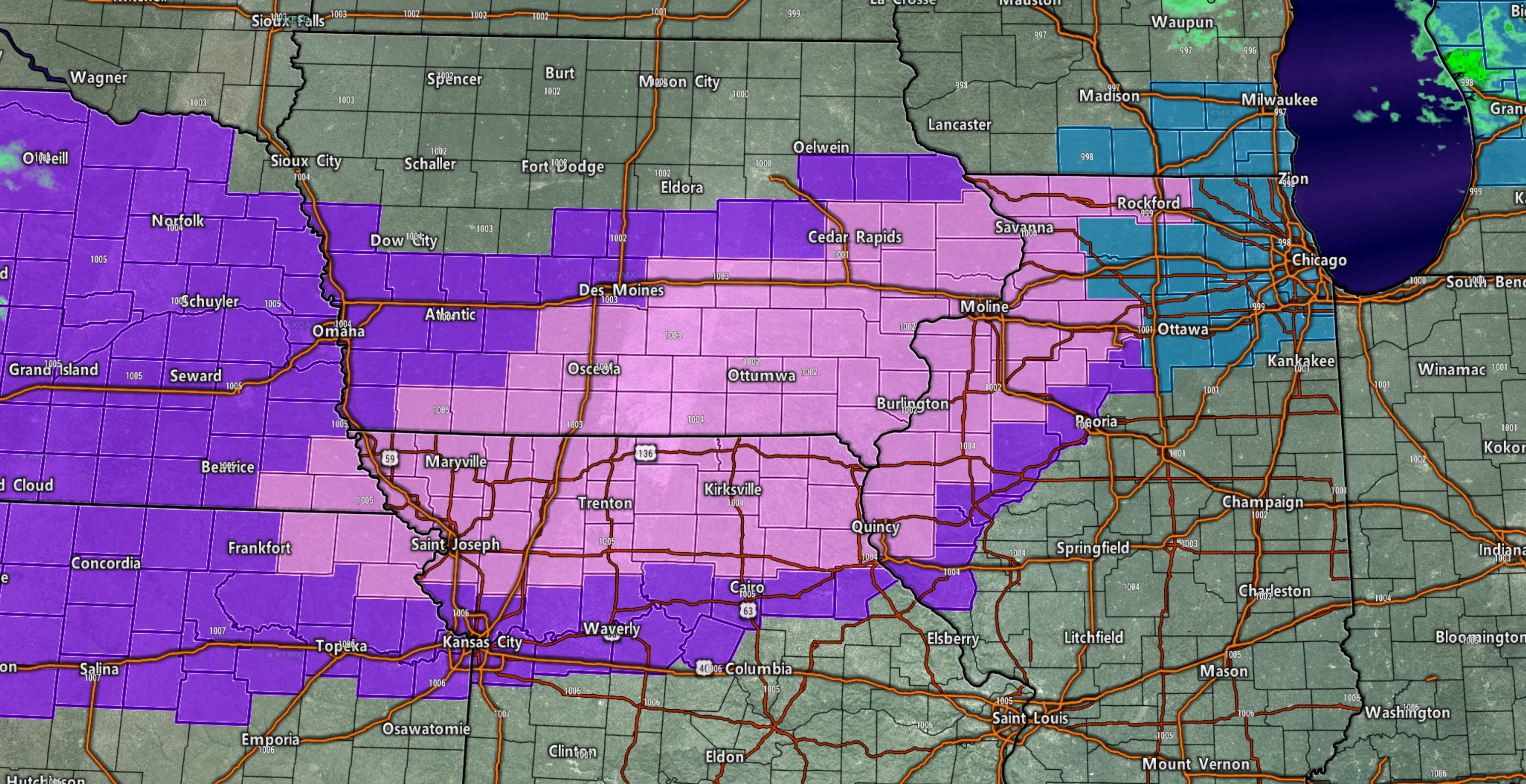
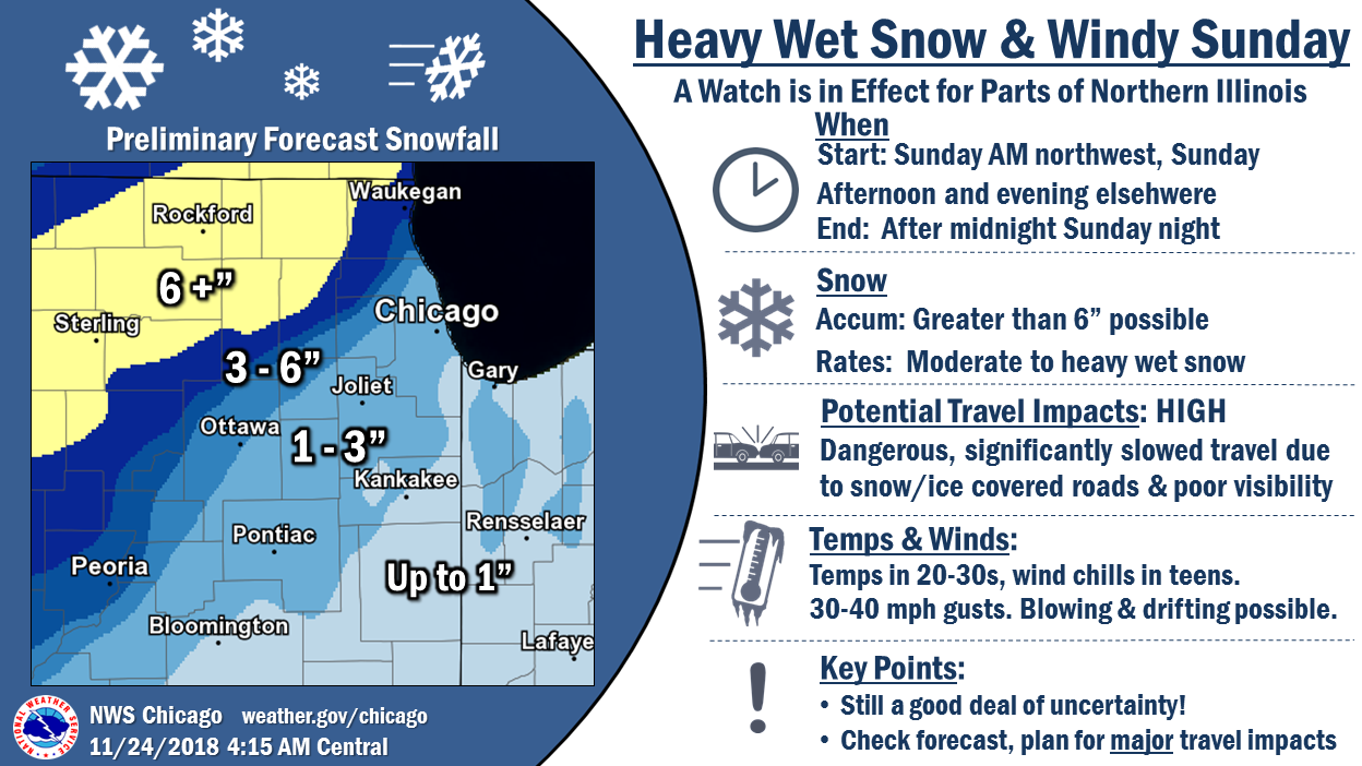
The Chicago Metro area is still a question mark when it comes to snow totals.
If the low tracks further south then Chicago will be hit hard. If the low tracks a bit further north then the impact will be greatly reduced.
The exact track of the low-pressure center is key to snow totals.
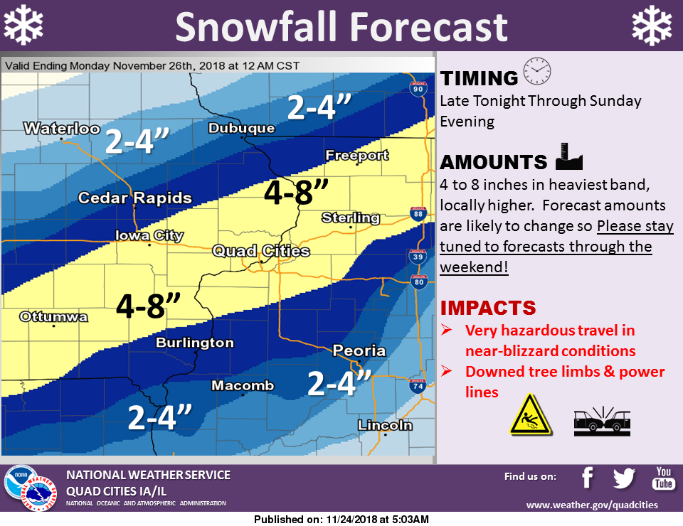
High winds are likely with this event, as well. Winds will gust above 40 mph in some areas with heavy snow. This will cause blowing and drifting snow. Near impossible travel conditions are likely in the heaviest snow zone.
Let’s look at some maps.
Here are the latest WPC probabilities for four or more inches of snow.
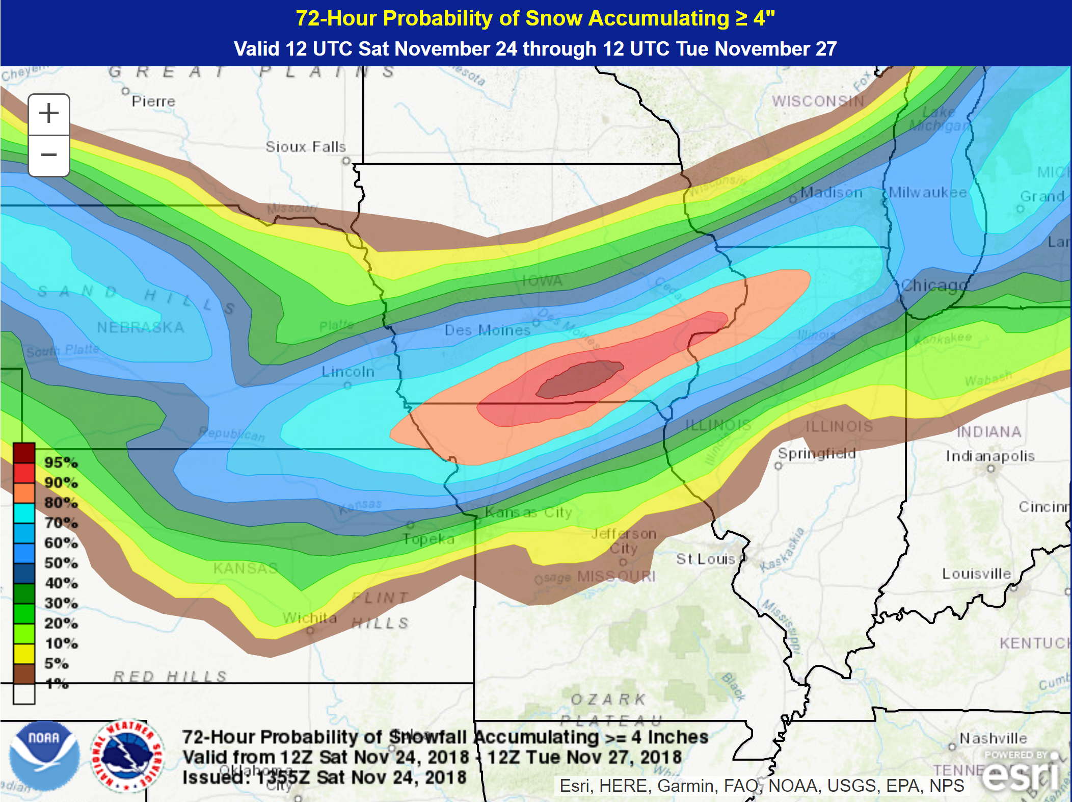
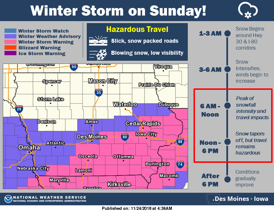
The peak of the storm for northeast Missouri into Illinois will be from Sunday morning into Sunday night. Peaking during the PM hours.
Snowfall rates of greater than one inch per hour are likely to occur in the heaviest snow bands. Although the snow will be wet, it appears the winds will be high enough to create near white-out conditions during the heaviest snow.
The snow should be wet. This will likely bring down power lines and tree limbs, as well.
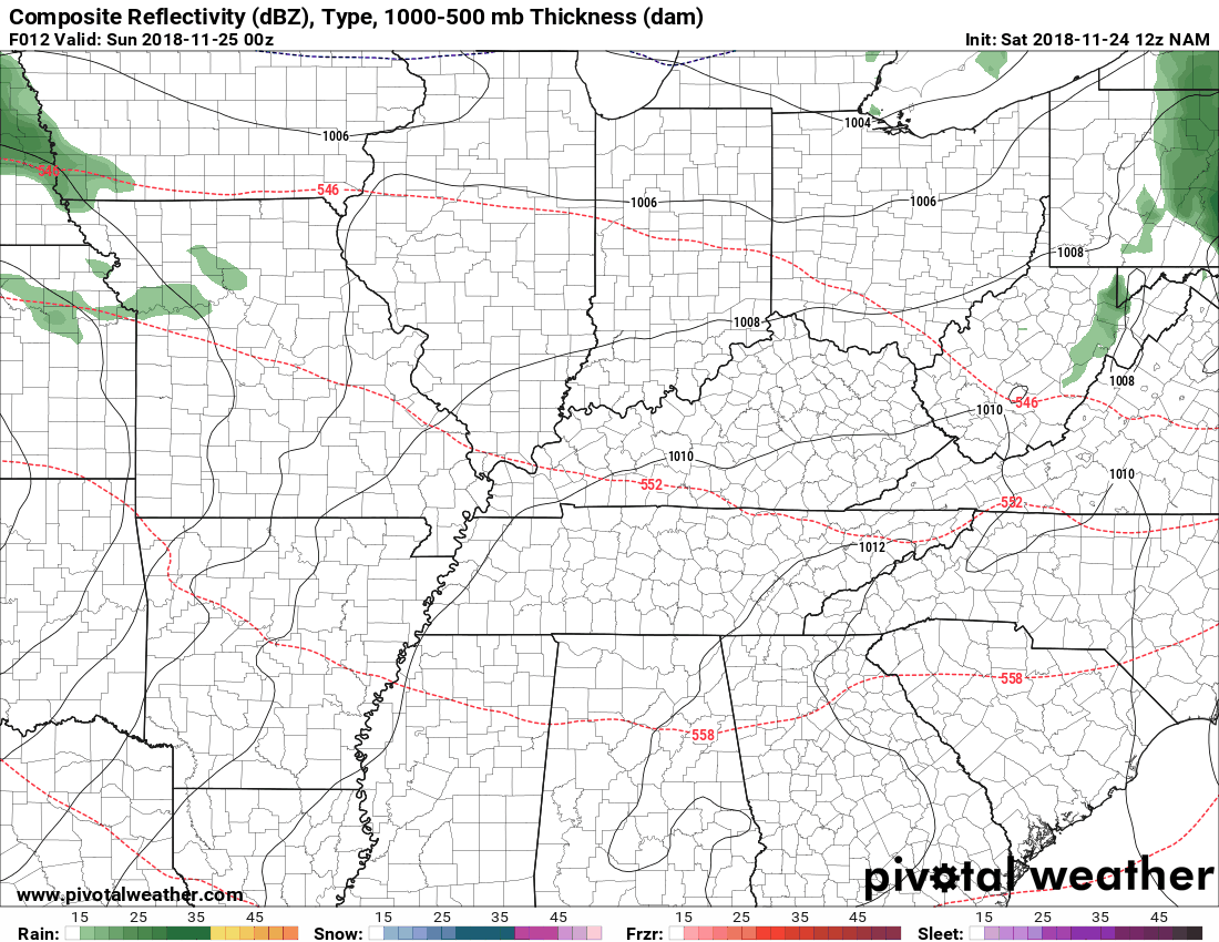
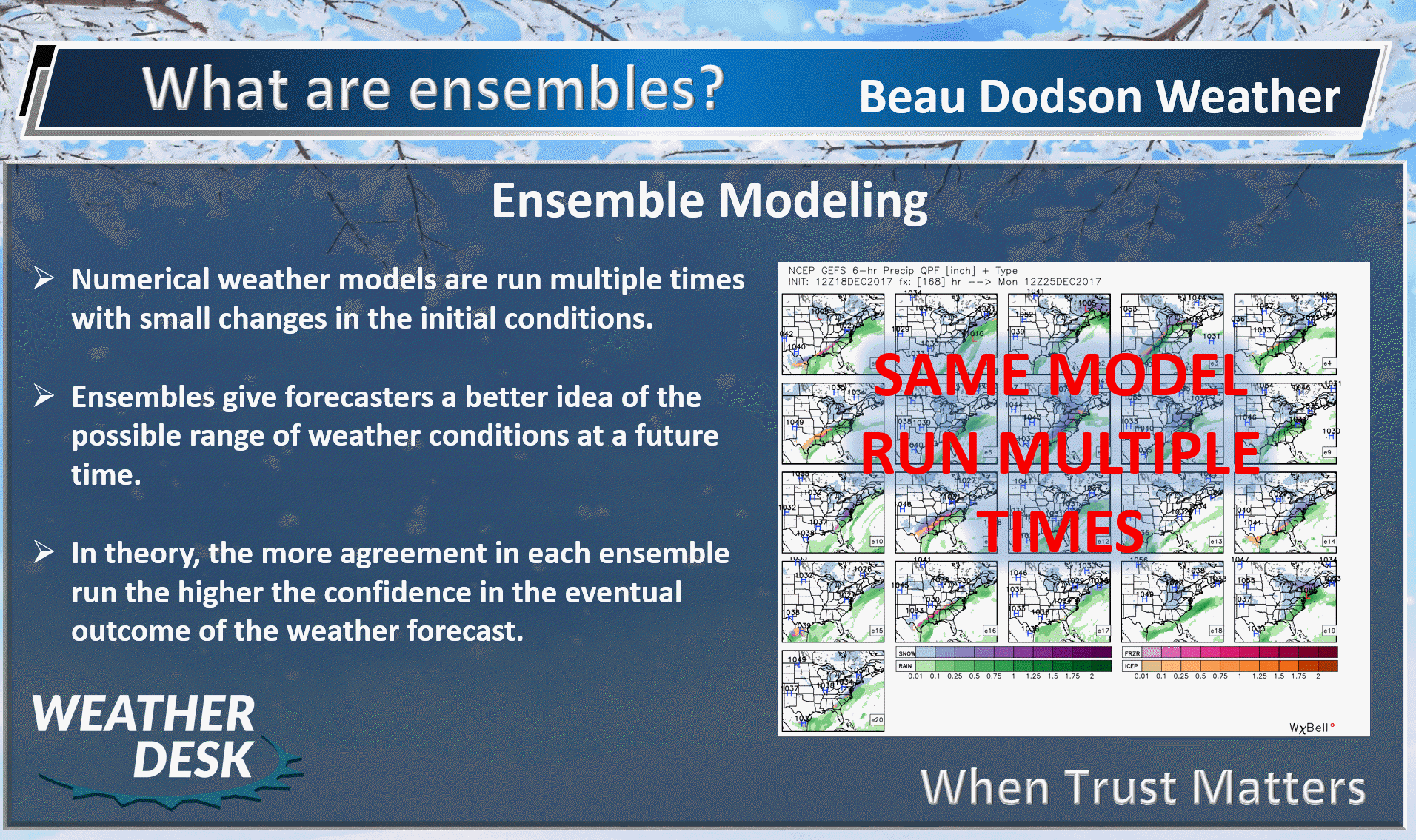
Let me show you a couple of model animations.
Green is rain. Blue is snow. The darker blue is heavier snow.
The time-stamp is located in the upper left corner of the animation.
Click all images on this page to enlarge them.
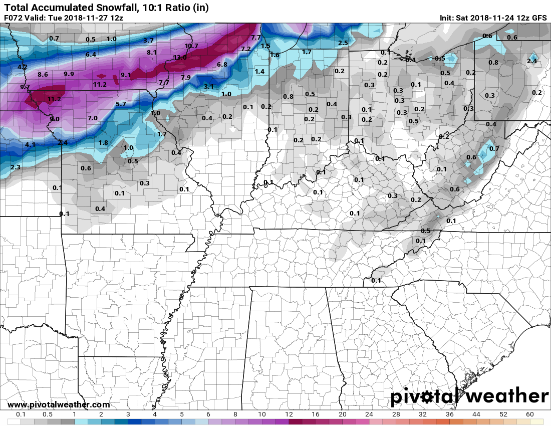
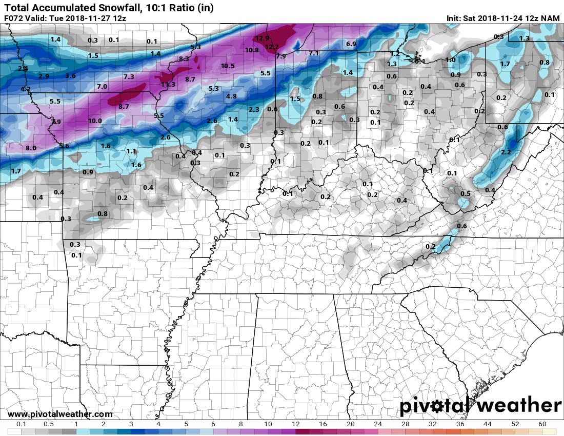
Here is the latest NAM guidance. You can see that it tracks the center of the low pressure over St Louis. This is further south than some of the other models.
The EC model has been showing a south track all along. This raises questions about placement of the most intense snow bands.
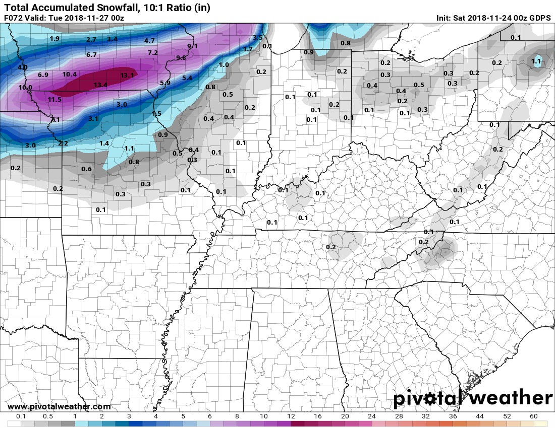
This next image is the GFS model guidance future-cast radar animation.
It tracks the low a tad further north than the NAM guidance.
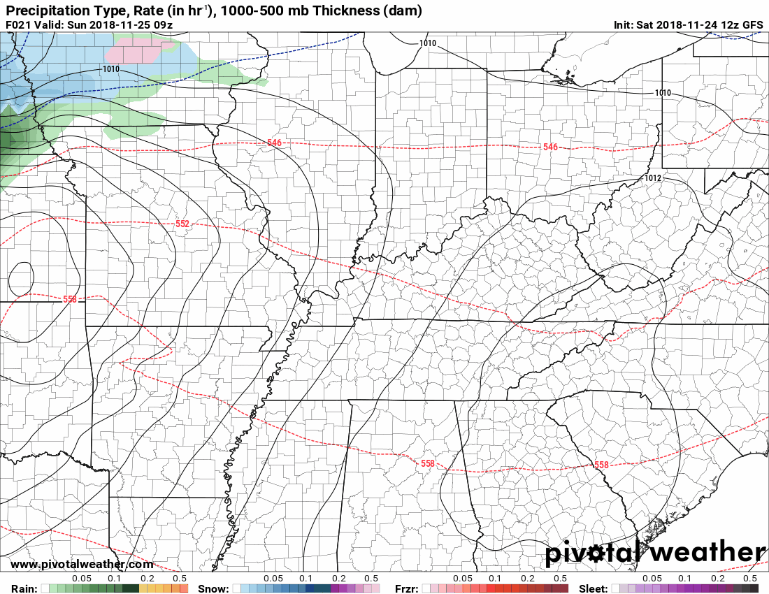
The EC guidance has always shown a more southerly track.
Here is the ensemble data concerning the placement of the low.
The EC is tightly clustered around central Illinois. Remember, the heaviest snow is north of the low.
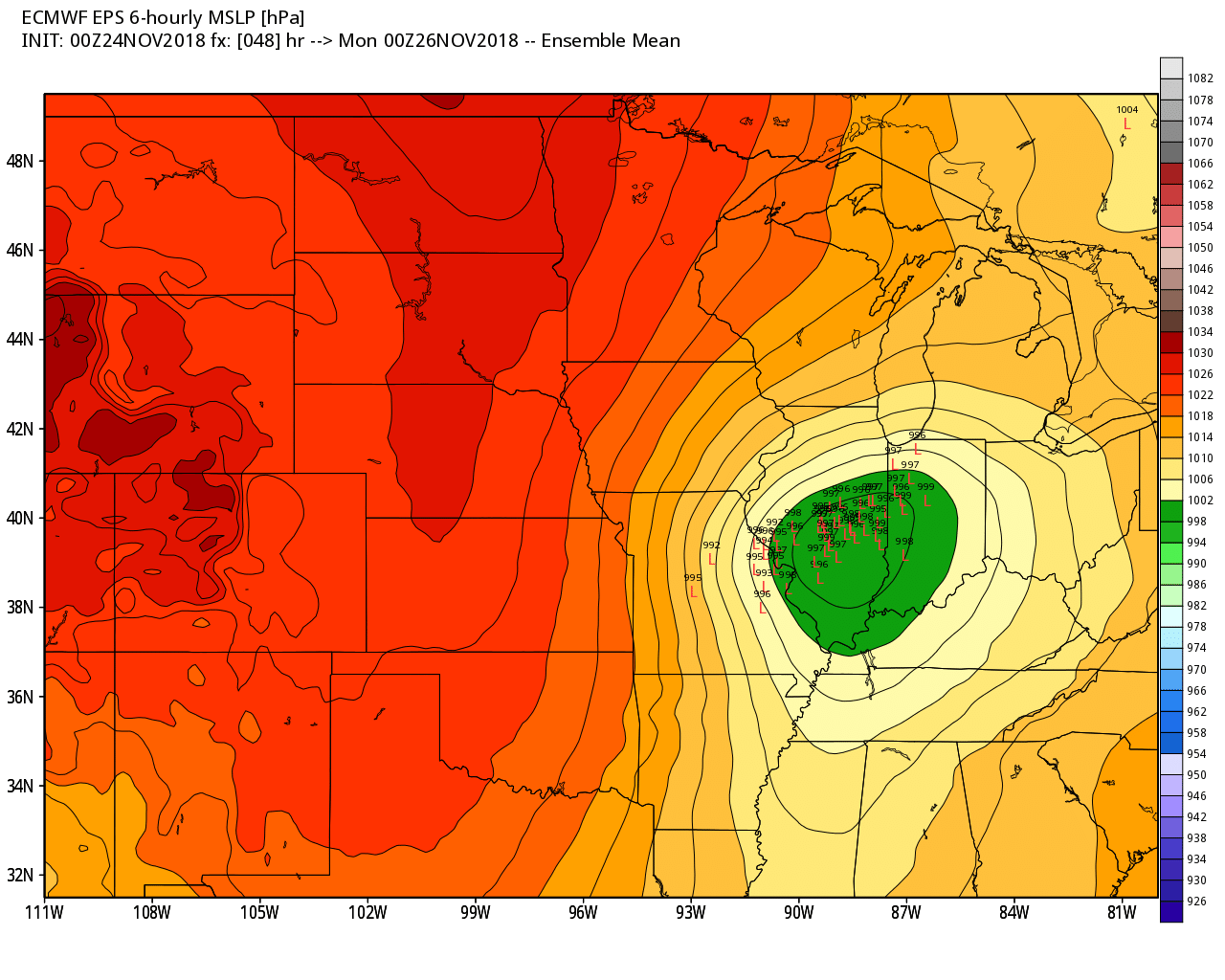
The EC model guidance paints northern Illinois in the heaviest snow zone.
Here is the mean number from all the ensembles.

Let me show you some more model guidance snow forecasts.
Most of these are within two to four counties of each other (when it comes to the heaviest band).
Click images to enlarge them.
GFS snow forecast
NAM snow forecast
3K NAM snow forecast
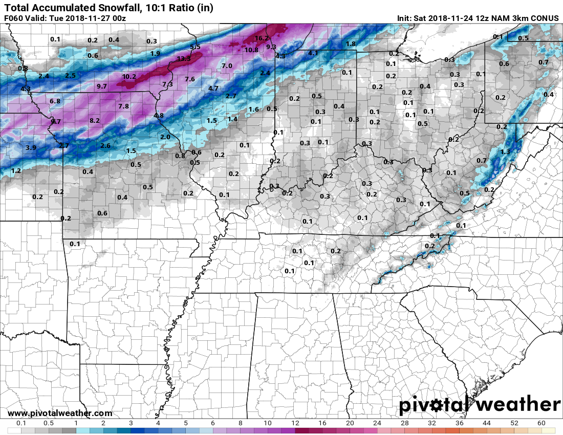
Canadian model snow forecast
Some more information from a variety of National Weather Service Offices.
Some of these maps may vary slightly, because of different forecasters. The general idea, however, is the same.
From west to east across Kansas to Indiana.
Click each image to enlarge it.
Our local forecast
November 24, 2018
Saturday forecast: Intervals of clouds. Cool temperatures. Temperatures will be dependent on cloud cover. If clouds are thicker then temperatures will be lower.
Temperatures: MO ~ 58 to 64 IL ~ 58 to 64 KY ~ 58 to 64 TN ~ 60 to 64
What is the chance of precipitation? MO ~ 0% IL ~ 0% KY ~ 0% TN ~ 0%
Coverage of precipitation: None
Is snow or ice anticipated? No
Wind: Becoming southwest at 6 to 12 mph with gusts to 20 mph
What impacts are anticipated from the weather? None
My confidence in the forecast verifying: High (70% confidence)
Is severe weather expected? No
The NWS defines severe weather as 58 mph wind or great, 1″ hail or larger, and/or tornadoes
Should I cancel my outdoor plans? No
UV Index: 3 to 4 Medium
Sunrise: 6:44 AM
Saturday Night Forecast Details:
Forecast: Mostly clear early. Some increase in clouds overnight. Cool temperatures. We should remain dry. There is a small chance of a light shower after 3 AM across our western counties of southeast Missouri. Patchy fog possible.
Temperatures: MO ~ 42 to 46 IL ~ 42 to 46 KY ~ 42 to 46 TN ~ 42 to 46
What is the chance of precipitation? MO ~ 10% late IL ~ 10% KY ~ 0% TN ~ 0%
Coverage of precipitation: Most likely none.
Is snow or ice anticipated? No
Wind: South at 7 to 14 mph with gusts to 20 mph
What impacts are anticipated from the weather? None
My confidence in the forecast verifying: Medium (60% confidence)
Is severe weather expected? No
The NWS defines severe weather as 58 mph wind or great, 1″ hail or larger, and/or tornadoes
Should I cancel my outdoor plans? No
Sunset: 4:39 PM
Moonrise: 6:17 PM Waning Gibbous
Moonset: 8:02 AM
November 25, 2018
Sunday forecast: Intervals of clouds. Becoming windy. We will have showers developing. Some areas may remain completely dry. The system is a bit moisture starved over our region. Rain totals will be on the light side. Less than 0.25″ is anticipated. Warmer ahead of the incoming cold front on southerly winds. Parts of western Kentucky and Tennessee could even approach the 70 degree mark.
Temperatures: MO ~ 55 to 60 IL ~ 58 to 64 KY ~ 64 to 70 TN ~ 65 to 70
What is the chance of precipitation? MO ~ 40% IL ~ 40% KY ~ 30% TN ~ 30%
Coverage of precipitation: Scattered
Is snow or ice anticipated? No
Wind: South and southeast winds becoming southwest and west as the front moves across the region. Strong and gusty winds likely. Wind speeds of 10 to 20 mph with gusts above 40 mph.
What impacts are anticipated from the weather? Wet roadways. Windy conditions.
My confidence in the forecast verifying: Medium (60% confidence)
Is severe weather expected? No
The NWS defines severe weather as 58 mph wind or great, 1″ hail or larger, and/or tornadoes
Should I cancel my outdoor plans? Monitor updates. Some rain will be possible.
UV Index: 1 to 2 Low
Sunrise: 6:45 AM
Sunday Night Forecast Details:
Forecast: Mostly cloudy. A few rain showers early in the night. Windy. Rain may end as non-accumulating snow. Turning colder. The best chance of snow flurries or snow showers will stretch from Cape Girardeau, Missouri, to Harrisburg, Illinois and then northeast of there. At this time it appears snow will not accumulate.
Temperatures: MO ~ 26 to 30 IL ~ 26 to 30 KY ~ 26 to 30 TN ~ 28 to 34
What is the chance of precipitation? MO ~ 40% to 50% IL ~ 50% KY ~ 40% TN ~ 40%
Coverage of precipitation: Ending early in the night.
Is snow or ice anticipated? Flurries or a snow shower possible. No accumulation anticipated.
Wind: West and northwest at 10 to 20 mph with gusts above 35 mph
What impacts are anticipated from the weather? Wet roadways. Falling temperatures behind the area of low pressure could turn the rain to flurries or snow showers.
My confidence in the forecast verifying: Medium (50% confidence)
Is severe weather expected? No
The NWS defines severe weather as 58 mph wind or great, 1″ hail or larger, and/or tornadoes
Should I cancel my outdoor plans? Monitor updates. Some rain will be possible.
Sunset: 4:39 PM
Moonrise: 7:14 PM Waning Gibbous
Moonset: 9:08 AM
November 26, 2018
Monday forecast: Partly sunny. Windy. Colder with well below normal temperatures. January like temperatures. Normal highs in January are in the middle 40’s.
Temperatures: MO ~ 35 to 40 IL ~ 36 to 40 KY ~ 38 to 44 TN ~ 38 to 44
What is the chance of precipitation? MO ~ 0% IL ~ 10% KY ~ 10% TN ~ 0%
Coverage of precipitation: Most likely none
Is snow or ice anticipated? No
Wind: Northwest winds at 10 to 20 mph with higher gusts.
What impacts are anticipated from the weather? None
My confidence in the forecast verifying: High (70% confidence)
Is severe weather expected? No
The NWS defines severe weather as 58 mph wind or great, 1″ hail or larger, and/or tornadoes
Should I cancel my outdoor plans? No
UV Index: 3 to 4 Low to medium
Sunrise: 6:46 AM
Monday Night Forecast Details:
Forecast: Mostly clear. Colder with well below normal temperatures.
Temperatures: MO ~ 23 to 26 IL ~ 23 to 26 KY ~ 24 to 28 TN ~ 24 to 28
What is the chance of precipitation? MO ~ 0% IL ~ 10% KY ~ 10% TN ~ 0%
Coverage of precipitation: None
Is snow or ice anticipated? No
Wind: West and northwest at 5 to 10 mph
What impacts are anticipated from the weather? None
My confidence in the forecast verifying: Medium (60% confidence)
Is severe weather expected? No
The NWS defines severe weather as 58 mph wind or great, 1″ hail or larger, and/or tornadoes
Should I cancel my outdoor plans? No
Sunset: 4:38 PM
Moonrise: 8:17 PM Waning Gibbous
Moonset: 10:08 AM

WeatherTalk monthly operating costs can top $2000.00. Your $5 subscription helps pay for those costs. I work for you.
The $5 will allow you to register up to seven phones!
For $5 a month you can receive the following. You may choose to receive these via your WeatherTalk app or regular text messaging.
Severe weather app/text alerts from my keyboard to your app/cell phone. These are hand typed messages from me to you. During tornado outbreaks, you will receive numerous app/text messages telling you exactly where the tornado is located.
- Daily forecast app/texts from my computer to your app/cell phone.
- Social media links sent directly to your app/cell phone. When I update the blog, videos, or Facebook you will receive the link.
- AWARE emails. These emails keep you well ahead of the storm. They give you several days of lead time before significant weather events.
- Direct access to Beau via text and email. Your very own personal meteorologist. I work for you!
- Missouri and Ohio Valley centered video updates
- Long-range weather videos
- Week one, two, three and four temperature and precipitation outlooks.
Monthly outlooks. - Your subscription also will help support several local charities.
Would you like to subscribe? Subscribe at www.beaudodsonweather.com
Typical progression on a severe weather day for subscribers.


I encourage subscribers to use the app vs regular text messaging. We have found text messaging to be delayed during severe weather. The app typically will receive the messages instantly. I recommend people have three to four methods of receiving their severe weather information.
Remember, my app and text alerts are hand typed and not computer generated. You are being given my personal attention during significant weather events.

WWW.WEATHERTALK.COM subscribers, here is my day to day schedule for your weather products.
The Weather Observatory will be holding two open houses for adults and children. Weather permitting, the open house will be Saturday, December 1st.
Class of 1988 (Massac County High School). I will be having a special open house for you on Friday, November 30th (the night before the other open house)

Did you know that you can find me on Twitter?

Subscribers, do you need a forecast for an outdoor event?


We offer interactive local city live radars and regional radars.
If a radar does not update then try another one. If a radar does not appear to be refreshing then hit Ctrl F5 on your keyboard.
You may also try restarting your browser. The local city view radars also have clickable warnings.
During the winter months, you can track snow and ice by clicking the winterize button on the local city view interactive radars.

Questions? Broken links? Other questions?
You may email me at beaudodson@usawx.com

The National Weather Service defines a severe thunderstorm as one that produces quarter size hail or larger, 58 mph winds or greater, and/or a tornado.
Today through Wednesday: No severe thunderstorms.
Interactive live weather radar page. Choose the city nearest your location. If one of the cities does not work then try a nearby one. Click here.
National map of weather watches and warnings. Click here.
Storm Prediction Center. Click here.
Weather Prediction Center. Click here.

Live lightning data: Click here.

Interactive GOES R satellite. Track clouds. Click here.

Here are the latest local river stage forecast numbers Click Here.
Here are the latest lake stage forecast numbers for Kentucky Lake and Lake Barkley Click Here.
Find me on Facebook!

Find me on Twitter!

Did you know that a portion of your monthly subscription helps support local charity projects?
You can learn more about those projects by visiting the Shadow Angel Foundation website and the Beau Dodson News website.

I encourage subscribers to use the app vs regular text messaging. We have found text messaging to be delayed during severe weather. The app typically will receive the messages instantly. I recommend people have three to four methods of receiving their severe weather information.
Remember, my app and text alerts are hand typed and not computer generated. You are being given personal attention during significant weather events.
