

November 13, 2014: This forecast update covers far southern Illinois, far southeast Missouri, and far western Kentucky. See the coverage map on the right side of the blog.
Thursday – Morning clouds then partly sunny and cold. A few snow flurries. No accumulation of snow. WELL below normal temperatures. North winds at 5-10 mph. Highs only around 35 degrees (normal highs this time of the year are around 62 degrees).
Morning School Bus Stop Weather – Partly sunny and cold. Temperatures around 30 degrees with a north wind of 5 mph.
Afternoon School Bus Stop Weather – A mix of sun and clouds. Cold. Temperatures will be around 35 degrees. North winds at 5 mph.
Thursday night – Mostly clear with well below normal temperatures. Cold. Low temperatures in the 18-22 degree range. Northwest winds at 5-10 mph.
Friday – A few clouds. Cold. High temperatures will likely not rise out of the 30’s. North winds at 5-10 mph.
Friday night – Mostly clear sky conditions. Cold for November. Lows will be in the 18-22 degree range. Northwest winds at 5 mph.
Saturday – Mostly sunny early. Increasing clouds by afternoon. Chilly. High temperatures around 38 degrees. Northwest winds at 5 mph.
A viewer picture this morning – this photograph was taken by Chris Conley. Thanks for sharing, Chris. Beautiful image. More images by Chris can be found here


An explanation of what is happening in the atmosphere over the coming days.
Cold weather has settled into the region. I suppose by now that you have your scarfs, mittens, and coats dusted off and placed prominently front and center. Probably for the best because the cold weather is not going anywhere. At least not for awhile. The good news is that the weather today and tomorrow will be on the tranquil side. Cold? Yes. But, at least it will be calm.
A few snowflakes around this morning. Nothing major. Just a reminder that winter has arrived a bit early.
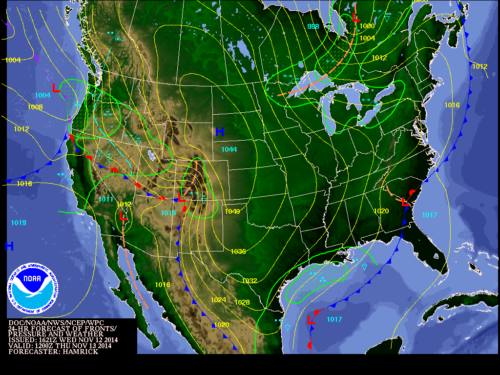
Here is the morning weather map. You can see the LARGE dome of cold high pressure (1044 mb) that has moved down out of Canada. This dome of high pressure will continue to push east/southeast over the coming 24 hours.
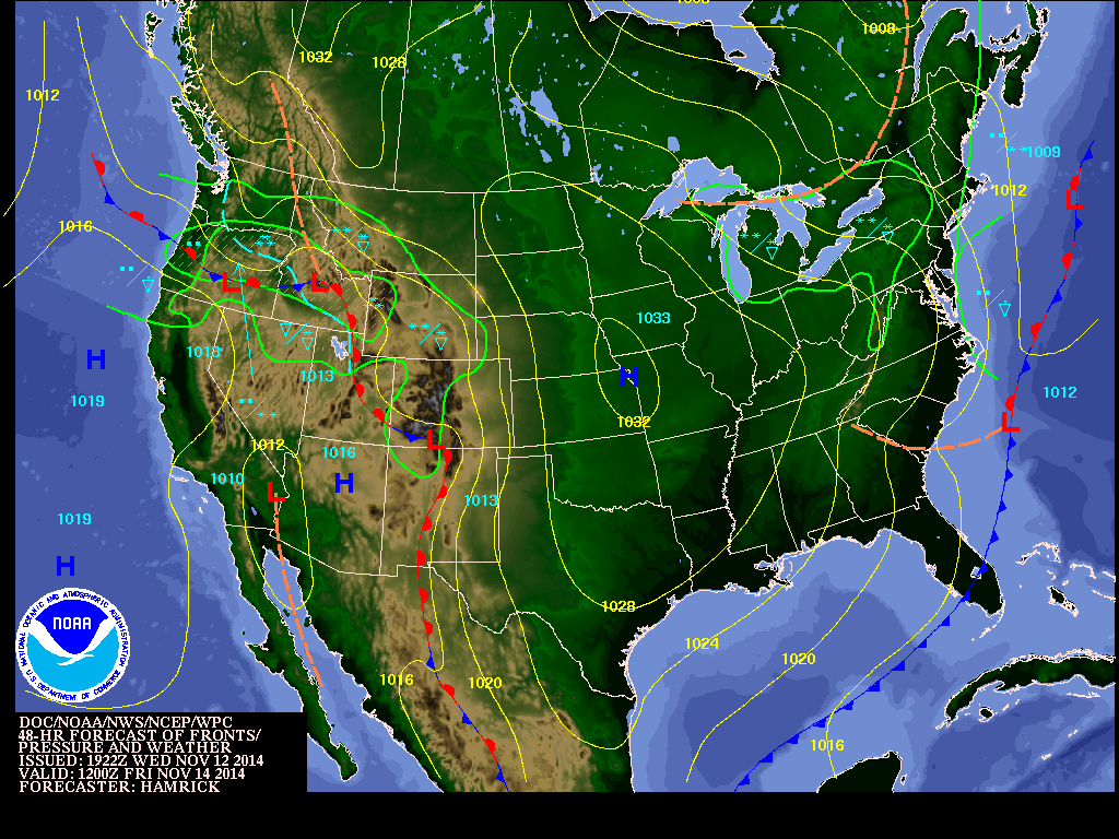
Here is the Friday morning weather map. You can see the high pressure is slowly shifting east/southeast.
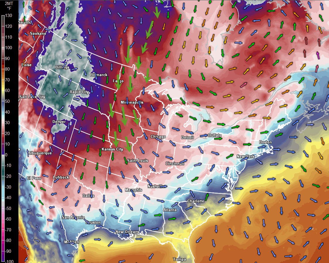
Let’s take a look at temperatures and the 850 mb (about 5000′ above the surface of the Earth) winds. The arrows indication what direciton the wind is moving. Do you notice WHERE The winds are coming out of? Basically straight south from the arctic circle and into Canada then into our region. This is why it is so cold outside.
The colors on this map represent temperatures. The scale is on the left side of the image. Yes, there are some -25 readings out in Idaho. Record cold temperatures.
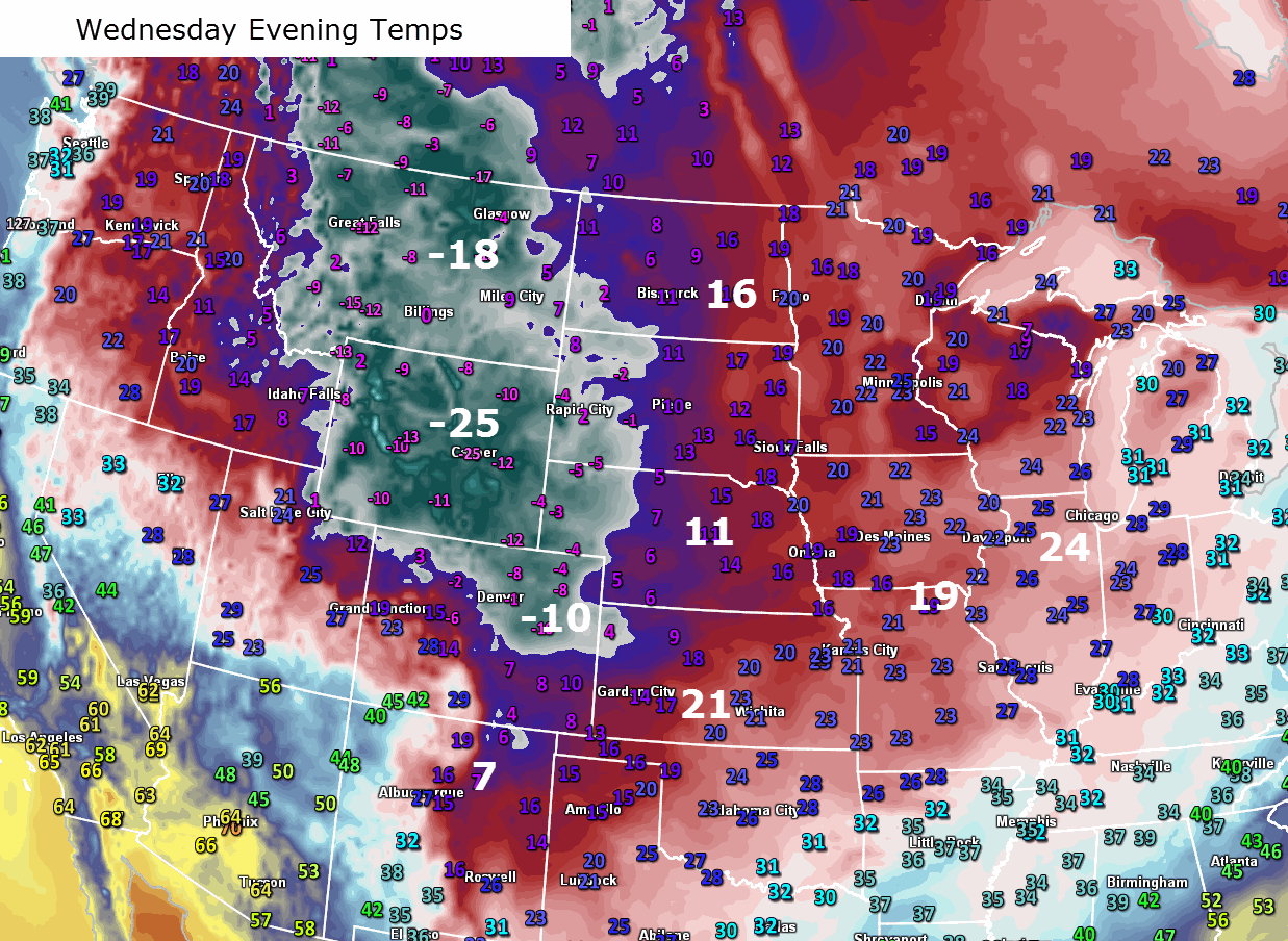
Here are some temperatures from last evening. Just look at these extreme (record breaking) numbers across parts of the Rockies.
Our next storm system arrives over the weekend. I am sure you have heard some chitter chatter about that subject. The infamous S word is being tossed around. I will dig a bit deeper (no pun intended) into that subject in the extended forecast (see down towards the middle of the page). For now, enjoy the crisp fall evenings and mornings!
Let’s take a look at current temperatures.

The current national temperature map

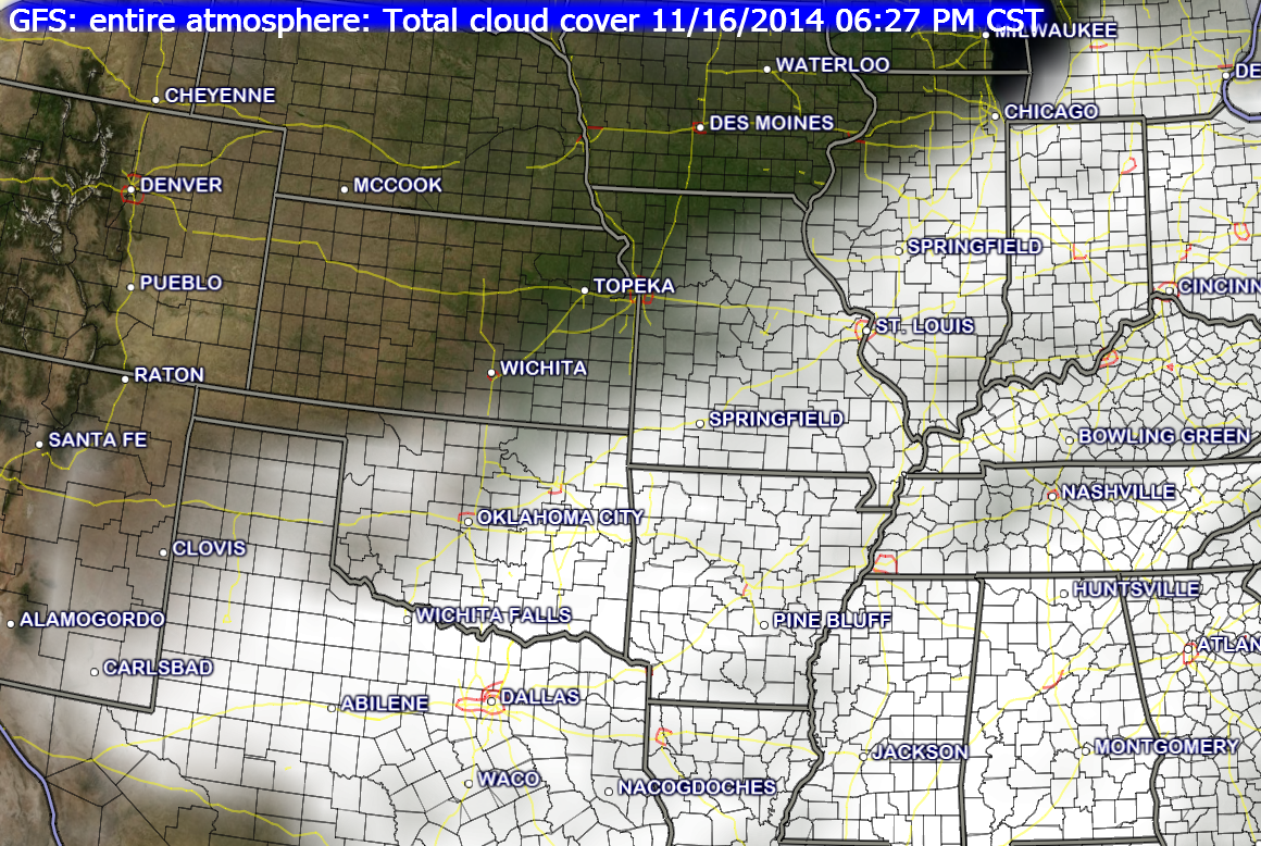
Your latest IR Satellite. Clouds lingering over the region. Should see some clearing later today.


No real changes in the ongoing forecast. Fairly straight forward with the daily high and low temperatures. A few spots will always end up a bit cooler than others. This is especially true in rural areas.
I did add some snow flurries to this mornings forecast.

No major concerns. Cold weather, of course. But, you can handle the chilly temperatures! Remember to change out the water bowls for your outdoor pets. The water should be frozen solid over the coming days.

The Wild Card gives you an idea of what might change that would cause the forecast to bust. A busted forecast means a forecast that does not verify. For example, if a winter storm (the area of low pressure) shifts its track 50 miles further south than expected, then that could cause a dramatic change in how much snow might or might not accumulate.
Wild card in this forecast will be overnight lows tonight. Some areas may dip into the teens. Everyone will dip well into the 20’s. We will see if a few spots touch 16, 17, 18, or 19 degrees. I can almost feel the excitement of you cold weather fanatics.

Can we expect severe thunderstorms over the next 24 to 48 hours? Remember that a severe thunderstorm is defined as a thunderstorm that produces 58 mph winds or higher, quarter size hail or larger, and/or a tornado.
Severe weather is not going to be a concern through next Monday.
Thunderstorm threat level is zero.


Will I need to take action?
Nothing of significance.

Please visit your local National Weather Service Office by clicking here. The National Weather Service Office, for our region, is located in Paducah, Kentucky.

A few flurries this morning. Nothing significant.
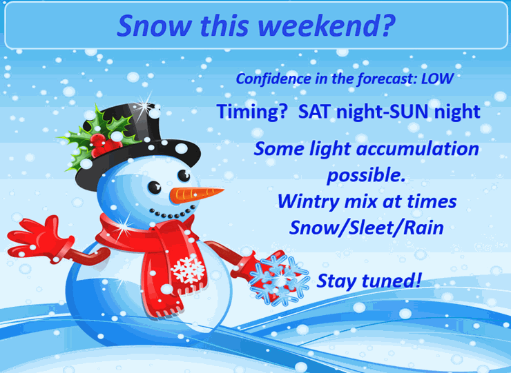
A light snow event (and wintry mix) is possible on Saturday night into Sunday night. Still some question as to whether there will just be some snowflakes in the air or whether snow might stick/accumulate. Either way, it does appear this is a fairly weak system. With the cold ground conditions there could be some light accumulations of the white gold.
Timing?
There will be two separate systems to monitor. The first will be Saturday night. The second will be Sunday afternoon and evening.
Temperatures could warm enough to support a rain/snow mix on Saturday evening. That would change to all snow.
Temperatures on Sunday should support a snow and sleet mix. Perhaps some rain mixed in for parts of the Missouri Bootheel and western Kentucky. This would change to all snow on Sunday evening.
Minor accumulations will be possible. The ground will be cold. Roads will also be cold. It only takes a hint of precipitation to cause problems. Keep this in mind.
Right now it appears that some spots could pick up a dusting to an inch of snow. Whether or not higher amounts are achieved will depend on a couple of factors. Banding is one of those factors. Banding can produce brief periods of moderate snow. My best comparison for banding would be training thunderstorms in the summer. Precipitation is enhanced in small areas for extended periods of time.
The Sunday system has some potential to produce a swipe or two of slightly higher snow amounts. Whether that occurs is still in question.
I am not a huge fan of forecasting snowfall amounts more than 24 hours in advance. Those who do forecast numbers ahead of that time frame often bust. Bust means a failed forecast. I am hoping to have a better handle of the systems by late on Friday and Friday night.
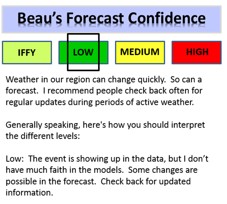
Thus, I recommend you check back for updated information. A forecast typically evolves and become more accurate as the event time approaches. I will hold the confidence level at low, for now.

Well, I already know what is on your mind. You are wondering if it is or is not going to snow this coming weekend. Then you are wondering HOW MUCH will it snow this weekend. No snow accumulation? A dusting of snow? One inch of snow?
I have to remind everyone that predicting snow in our region is tricky, at best. It only takes slight changes in storm track to completely change the forecast. How many times have we watched a winter storm move into our region and produce more or less snow than forecast? Almost every event is that way. I have witnessed forecasts bust the day of an event!
If one night, during the summer months, I told you that it was going to rain 0.10″ would you care? Would you even know if it rained? Many of you could not care less. BUT – did you know that 0.10″ of rain actually equals 1″ of snow! In other words if you melted down 1″ of snow you would end up with 0.10″ of liquid water (most of the time).
You see how hard it is to forecast snowfall amounts? Forecasting 0.10″ of precipitation is rarely a sure bet. What happens if you end up with 0.20″ of precipitation? Well, then you would have 2″ of snow. Does the entire area typically experience the exact same amount of precipitation? No. I have never witnessed the entire forecast area receive 0.10″ of rain. Some spots receive more and some receive less.
There is a lot of pressure on forecasters to split hairs on whether a dusting of snow will fall, 1″ of snow will fall, or 2″ of snow will fall. Sometimes you have all of the above in your front yard (especially true with wind blown snow).
My point is that there isn’t a forecaster in our region that can accurately forecast snowfall TOTALS more than a day or so in advance. Yes, you will hear people 3, 4, and 5 days in advance start throwing numbers around. But, how often do they nail a storm days in advance? Rarely. Sometimes they get it right – sometimes they get it wrong.
What I can tell you is that some light snow is possible on Saturday night into Sunday. I am fairly confident that snow will fall from the sky. I am not confident on whether or not the snow will accumulate. Not confident enough to forecast exact totals at different locations.
The ground is cold. This should help the snow accumulate. There are some questions as to whether there will be periods of mixed precipitation, as well. That means some sleet and rain. Even with all of that said, there remain questions as to whether this system will actually produce accumulating snow for our area. Monitor updates as we move forward.
The computer models are showing everything from a trace of snow (dusting) to several inches of snow. Those numbers change considerably from one model to another. Some of the data shows a slightly heavier band of snow from northwest Tennessee into southwest Kentucky and then northeast towards Louisville. Other models show very little snow falling in those areas.
Too soon to make a forecast call on how much snow will fall. It appears to be a light event. Light event means snowflakes in the air, a dusting to an inch or so of snow.
At this time, I don’t see a scenario that would produce BIG snow amounts. But, as always, I will monitor. You snow fans – keep your snow candles lit…still some time for adjustments in the forecast.
Confidence will grow with each passing day, concerning the exact track of the snow and the possibility of snowfall accumulation. It might not be until Friday or Friday night before confidence is a bit higher as to exactly what will happen with this particular system.
For now, confidence in the forecast remains low.
Just for fun 🙂 – I know some of you are more into weather than others. Let me give you a peek into some of the maps I look out when forecasting precipitation.
Let’s take a look at some upper level maps.
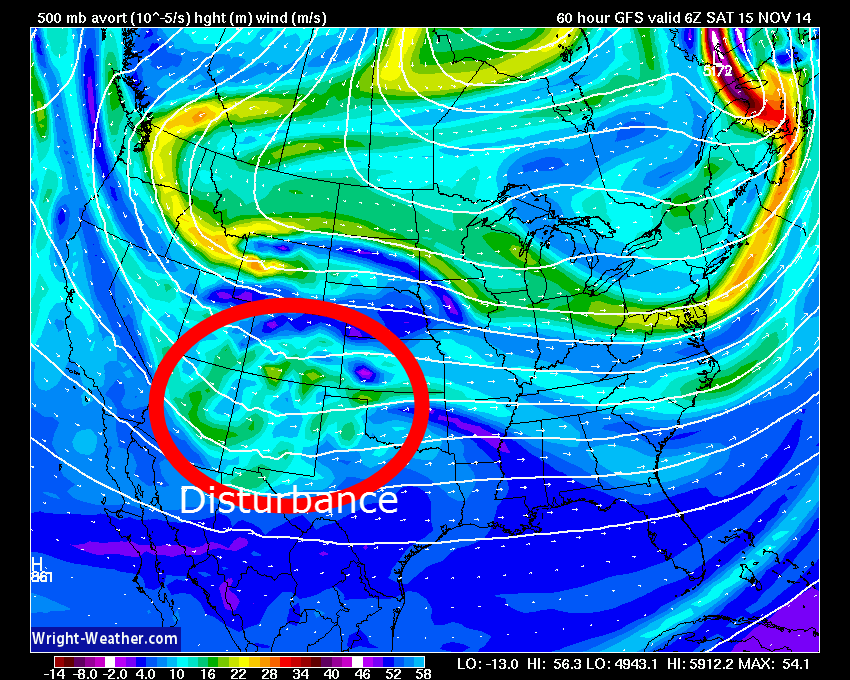
Here is the 500 mb vorticity map for Saturday. You can see some energy moving out of the southwest United States and into the Central United States. This is an area of lift. As this moves into the Central U.S. it will help cause lift in the atmosphere. Lift is one ingredient required for clouds and precipitation.
I have circled the weak disturbance.
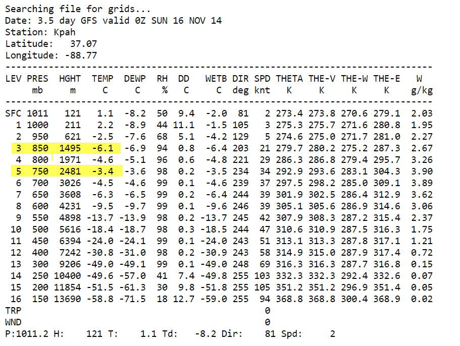
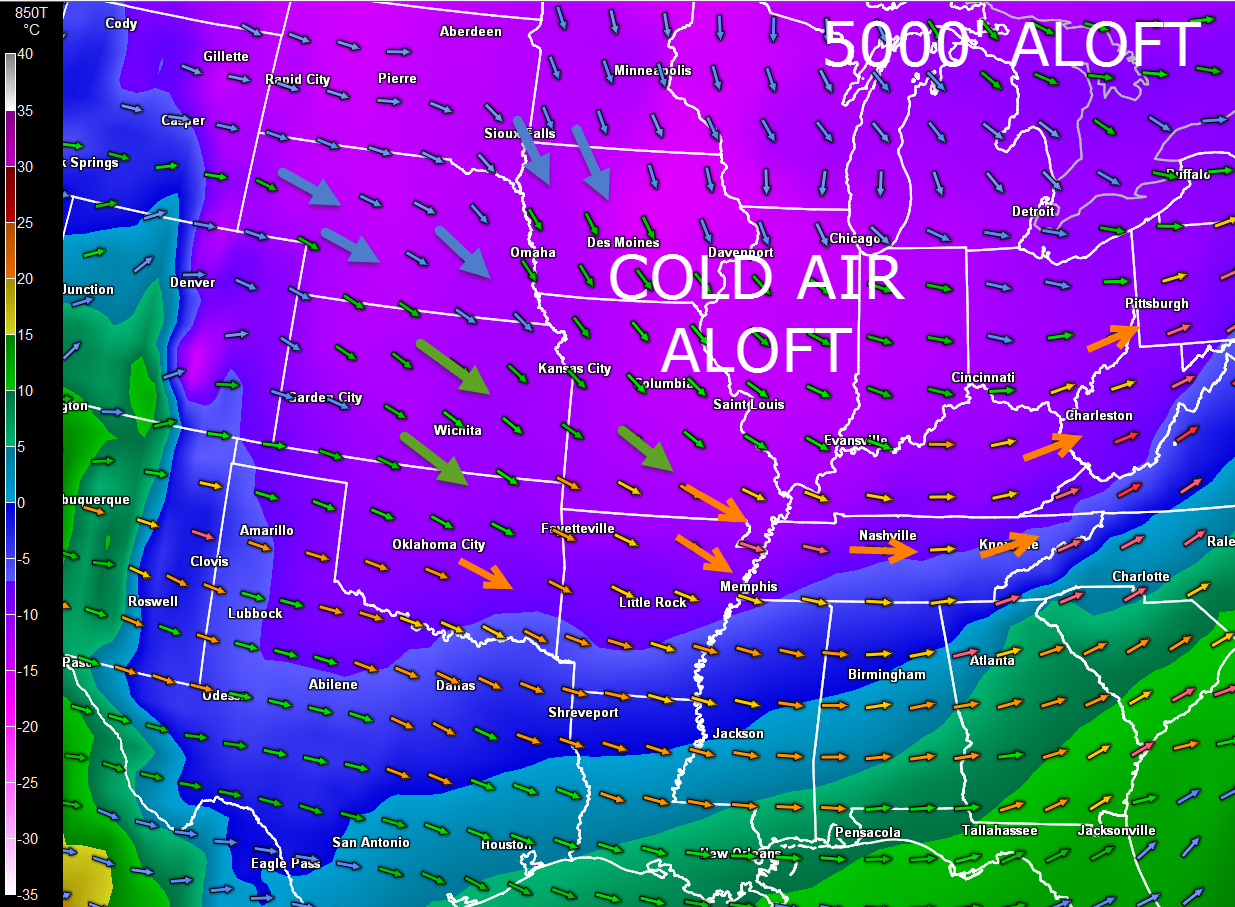
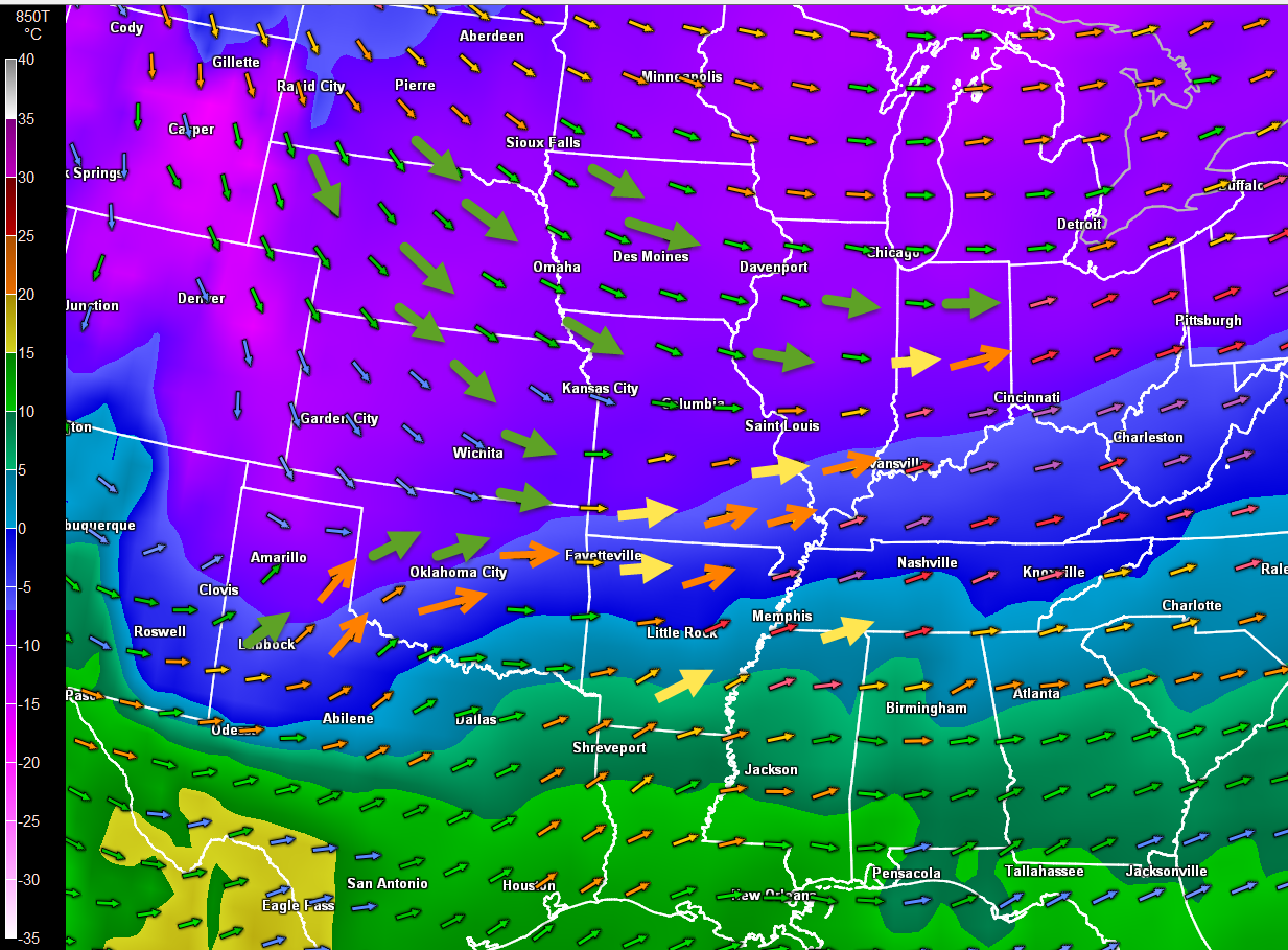
The follwing two maps show you the temperature at 5000′ above the Earth’s surface. This is called the 850 mb level. The 850 mb level is around 5000 feet. Meteorologist use these temperature maps to determine where cold or warm air advection is occurring. The arrows you see on the map indicate the wind speed and direction at the 700 mb level. The 700 mb level is about 10,000 feet above the Earth’s surface. Stay with me here 🙂
Notice on the first map that the winds are out of the northwest. The winds at 10,000′ are out of the northwest. These winds are coming out of the Central and Northern Plains. Mostly dry air advecting into our region.
Notice on the second image (this is where I will bring it together for you) that the winds have TURNED. They are now out of the southwest. What happens when winds blow out of the south or southwest in our region? Typically that means that the atmosphere is going to moisten up. The winds have a source region of the Pacific Ocean or the Gulf of Mexico. These are areas where moisture is deeper. When warmer air (750 mb level) moves over colder air (the 850 mb chart) then normally clouds and precipitation occurs.
Let me show you what I mean by warmer air aloft moving over colder air. Remember that the 850 mb level is at 5000′ above the surface. The 700 mb level is at 10,000′ above the surface.
Here is the forecast temperatures are those two levels on Saturday evening. At the 850 mb level the temperature is around -6.1 Celsius. At the 700 mb level the temperature is -3.4 Celsius. Warmer air moving over colder air.
FIRST image – shows you the northwest winds over our region today.
SECOND image shows you the wind flow becoming southwest (the wind arrows are point out of the southwest and towards the northeast). This occurs on Saturday and Sunday. The color of the wind barbs indicate different wind speeds.
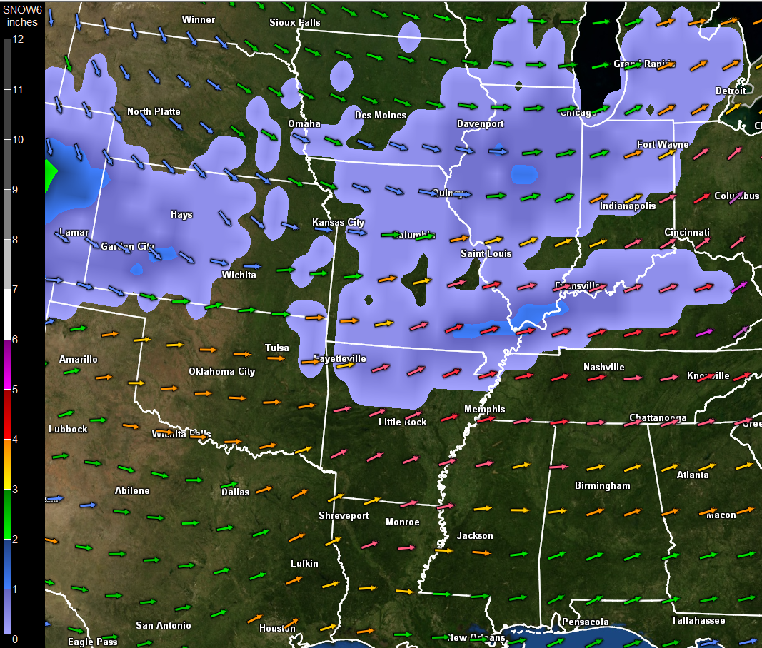
Here is one more image for you. This map (below) shows you the 700 mb winds. The blue colors represent snowfall. This is just one models opinion on where snow might stick to the ground. Don’t get too caught up in that subject. I am just showing you how the process works.
Notice how that southwest flow brings about that overrunning precipitation. Warm air moving over cold air produces clouds and precipitation.
Here is the future-cast satellite view for Saturday evening. See all the clouds – the broad area of white? The southwest flow aloft is bringing warmer air up and over the cold air. This is causing clouds to form. Lots of clouds on Saturday afternoon into Sunday.
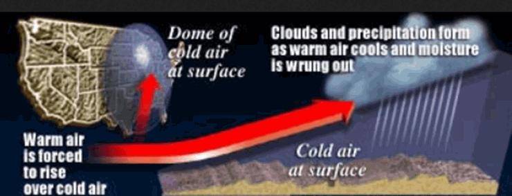
Graphic (I found online) that shows you an illustration of warm air moving over cold air.
Anyway, gee you bring the weather geek out in me. Hope you learned something.
The latest 6-10 day temperature and precipitation outlook. Will temperatures be ABOVE or BELOW normal?


The latest 8-14 day temperature and precipitation outlook. Note the dates are at the top of the image. These maps simply give you the probability as to whether temperatures or precipitation will be above or below normal.


Current tower cam view from the Weather Observatory- Click here for all cameras.

Southern Illinois Weather Observatory

The Weather Observatory

Southern Illinois Weather Observatory
WPSD TV 6 has a number of tower cameras. Click here for their tower camera page
& Kentucky Road Conditions & Kentucky Highway and Interstate Cameras

Downtown Paducah, Kentucky
Benton, Kentucky Tower Camera – Click here for full view

Benton, Kentucky
WSIL TV 3 has a number of tower cameras. Click here for their tower camera page
& Illinois Road Conditions

Marion, Illinois

You can sign up for my AWARE email by clicking here I typically send out AWARE emails before severe weather, winter storms, or other active weather situations. I do not email watches or warnings. The emails are a basic “heads up” concerning incoming weather conditions.