

.
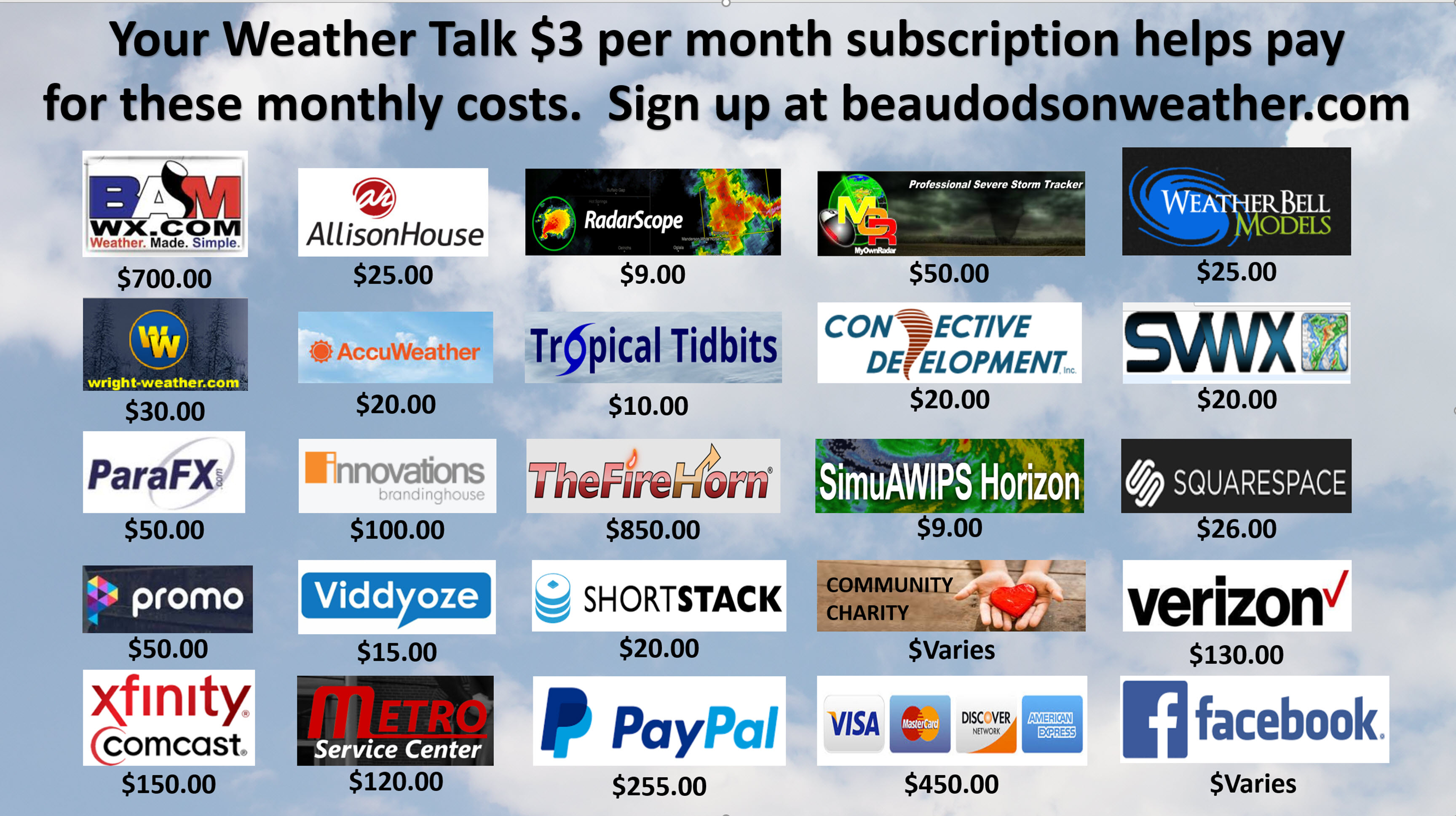
A Weather Talk subscription ($3 a month) is required to view the videos. This helps cover monthly costs (which can run between one and two thousand dollars).
Videos are posted on the www.weathertalk.com website. Once there, click the Beau Video-Cast tab. Long Range Video Update
If you believe you missed a video then you may check the LIVE FEED link on the Weather Talk website. You will find an archive of videos on that page.
You can also receive the videos via your Weather Talk app/text messages. Turn text option FOUR to the on position. The Weather Extra text option. Sign up for the app/text messages, videos, and more at www.beaudodsonweather.com
Your $3 a month helps cover the following monthly costs. These are my out of pocket expenses.
This forecast covers the counties in red. The counties in orange are covered by the forecast discussion further down in the blog.


November 12, 2017
Sunday Night Forecast Details:
Forecast: Cloudy. Any remaining showers will have ended. Cool temperatures.
Temperatures: MO ~ 33 to 36 IL ~ 32 to 36 KY ~ 34 to 38
Wind chill values: N/A
Snow or ice: No
Winds: North and northwest 5 to 10 mph with gusts to 14 mph
What impacts are anticipated from the weather? Most likely none.
My confidence in the forecast verifying: High
Is severe weather expected? No
The NWS defines severe weather as 58 mph wind or great, 1″ hail or larger, and/or tornadoes
Is freezing rain, sleet, or snow expected? No
What is the chance of precipitation? MO ~ 10% IL ~ 10% KY ~ 20%
Coverage of precipitation: None. Rain ending.
Should I cancel my outdoor plans: No, but check radars early in the evening. The rain should have ended.
.
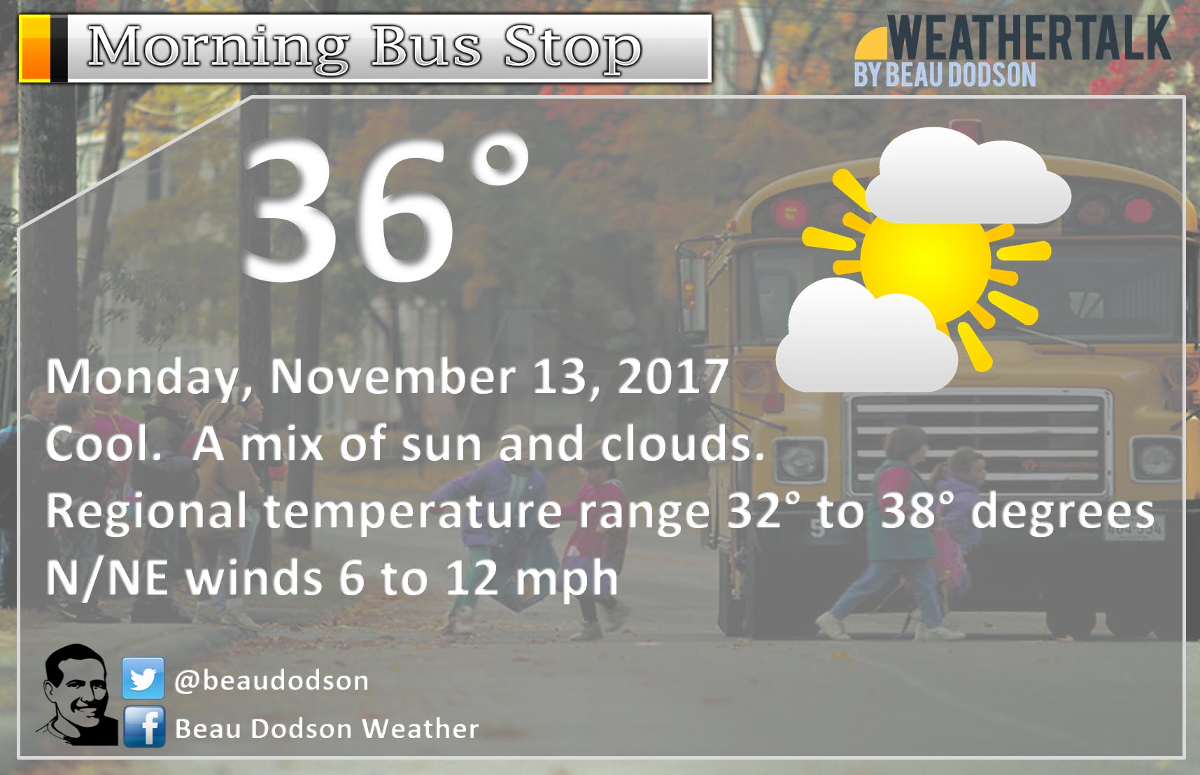
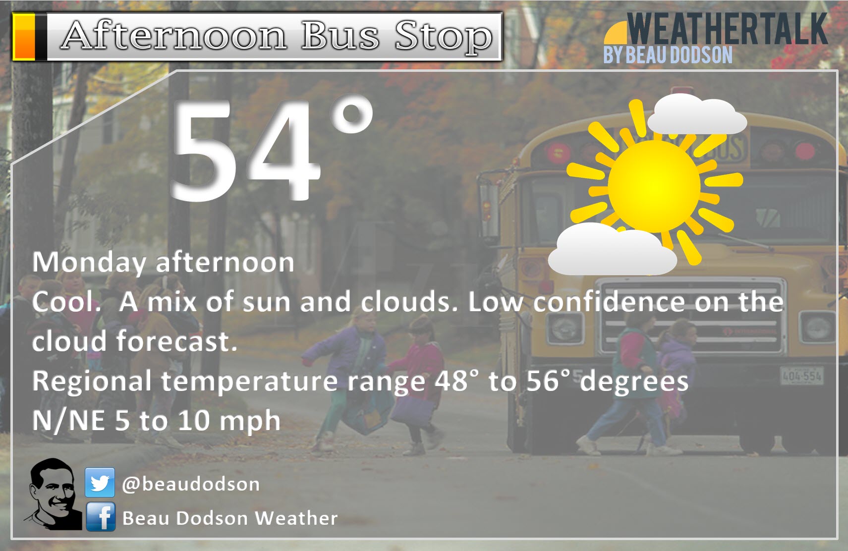
November 13, 2017
Monday Forecast Details
Forecast: Quite a few morning clouds. Chilly. Clouds may linger into the afternoon, but breaks will develop. Patches of sun. Some areas may become sunny as the cloud bank erodes.
Temperatures: MO ~ 48 to 56 IL ~ 46 to 54 KY ~ 50 to 55 Temps on Monday will be highly dependent on cloud cover.
Wind chill values: N/A
Snow or ice: No
Winds: North and northeast at 5 to 10 mph. Gusts to 14 mph possible during the morning.
What impacts are anticipated from the weather? None
My confidence in the forecast verifying: Medium
Is severe weather expected? No
The NWS defines severe weather as 58 mph wind or great, 1″ hail or larger, and/or tornadoes
Is freezing rain, sleet, or snow expected? No
What is the chance of precipitation? MO ~ 0% IL ~ 0% KY ~ 0%
Coverage of precipitation: None
Should I cancel my outdoor plans? No
.
November 13, 2017
Monday Night Forecast Details:
Forecast: Partly cloudy. There is a chance of clouds lingering in some areas. Clouds often times are slow to leave during the fall and winter months. They find themselves trapped under an inversion (a layer of warm air aloft). It will be chilly. Fog may form if clouds clear.
Temperatures: MO ~ 32 to 36 IL ~ 32 to 36 KY ~ 34 to 38
Wind chill values: N/A
Snow or ice: No
Winds: East and northeast 3 to 6 mph
What impacts are anticipated from the weather? Patchy fog.
My confidence in the forecast verifying: Medium
Is severe weather expected? No
The NWS defines severe weather as 58 mph wind or great, 1″ hail or larger, and/or tornadoes
Is freezing rain, sleet, or snow expected? No
What is the chance of precipitation? MO ~ 0% IL ~ 0% KY ~ 0%
Coverage of precipitation: None
Should I cancel my outdoor plans: No
.
November 14, 2017
Tuesday Forecast Details
Forecast: Partly sunny. A small chance of showers towards evening over southeast Missouri.
Temperatures: MO ~ 55 to 60 IL ~ 55 to 60 KY ~ 55 to 60
Wind chill values: N/A
Snow or ice: No
Winds: East and southeast 5 to 10 mph
What impacts are anticipated from the weather? None
My confidence in the forecast verifying: High
Is severe weather expected? No
The NWS defines severe weather as 58 mph wind or great, 1″ hail or larger, and/or tornadoes
Is freezing rain, sleet, or snow expected? No
What is the chance of precipitation? MO ~ 20% (after 3 pm) IL ~ 10% (late in the day) KY ~ 10%
Coverage of precipitation: None to isolated.
Should I cancel my outdoor plans? No
.
Tuesday Night Forecast Details:
Forecast: Clouds thickening. Shower chances will be on the increase (mainly late). Thunderstorms are possible late.
Temperatures: MO ~ 40 to 45 IL ~ 40 to 45 KY ~ 40 to 45
Wind chill values: N/A
Snow or ice: No
Winds: South and southeast winds increasing to 5 to 10 mph
What impacts are anticipated from the weather? Wet roadways. Lightning.
My confidence in the forecast verifying: High
Is severe weather expected? No
The NWS defines severe weather as 58 mph wind or great, 1″ hail or larger, and/or tornadoes
Is freezing rain, sleet, or snow expected? No
What is the chance of precipitation? MO ~ 50% IL ~ 50% KY ~ 40%
Coverage of precipitation: Scattered
Should I cancel my outdoor plans: No, but check radars
.
November 15, 2017
Wednesday Forecast Details
Forecast: Cloudy. Showers likely. A thunderstorm possible.
Temperatures: MO ~ 54 to 58 IL ~ 54 to 58 KY ~ 54 to 58
Wind chill values: N/A
Snow or ice: No
Winds: South and southwest at 8 to 16 mph. Gusty winds, at times.
What impacts are anticipated from the weather? Wet roadways and lightning.
My confidence in the forecast verifying: High
Is severe weather expected? No
The NWS defines severe weather as 58 mph wind or great, 1″ hail or larger, and/or tornadoes
Is freezing rain, sleet, or snow expected? No
What is the chance of precipitation? MO ~ 60% IL ~ 60% KY ~ 60%
Coverage of precipitation: Numerous
Should I cancel my outdoor plans? Have a plan B. Check updates and radars
.
Wednesday Night Forecast Details:
Forecast: Evening clouds. Isolated showers. I believe most of the rain will have ended. Cool temperatures. If we clear out then fog would be possible.
Temperatures: MO ~ 38 to 42 IL ~ 38 to 42 KY ~ 38 to 42
Wind chill values: N/A
Snow or ice: No
Winds: West and northwest at 3 to 6 mph
What impacts are anticipated from the weather? Perhaps wet roadways early. Most of the rain should have ended.
My confidence in the forecast verifying: Medium
Is severe weather expected? No
The NWS defines severe weather as 58 mph wind or great, 1″ hail or larger, and/or tornadoes
Is freezing rain, sleet, or snow expected? No
What is the chance of precipitation? MO ~ 20% IL ~ 20% KY ~ 30%
Coverage of precipitation: Scattered. Ending.
Should I cancel my outdoor plans: No
.
November 16, 2017
Thursday Forecast Details
Forecast: Partly sunny. Warmer. Isolated shower possible.
Temperatures: MO ~ 58 to 64 IL ~ 58 to 64 KY ~ 58 to 64
Wind chill values: N/A
Snow or ice: No
Winds: North and northeast winds at 5 to 10 mph.
What impacts are anticipated from the weather? None
My confidence in the forecast verifying: High
Is severe weather expected? No
The NWS defines severe weather as 58 mph wind or great, 1″ hail or larger, and/or tornadoes
Is freezing rain, sleet, or snow expected? No
What is the chance of precipitation? MO ~ 10% IL ~ 10% KY ~ 10%
Coverage of precipitation: None to isolated. I believe Thursday *during the day* will remain dry.
Should I cancel my outdoor plans? No
.
Thursday Night Forecast Details:
Forecast: Cloudy. Temperatures may hold steady or rise. A warm front will be pushing into the region. A few showers and thunderstorms will be possible along and north of the front. There are some questions about Thursday night’s rain chances. I have added a 30% chance. I will monitor trends in case adjustments are necessary.
Temperatures: MO ~ 46 to 52+ IL ~ 46 to 52+ KY ~ 46 to 52+
Wind chill values: N/A
Snow or ice: No
Winds: East and southeast winds becoming south/southeast at 10 to 20 mph.
What impacts are anticipated from the weather? Wet roadways. Lightning.
My confidence in the forecast verifying: Medium
Is severe weather expected? No
The NWS defines severe weather as 58 mph wind or great, 1″ hail or larger, and/or tornadoes
Is freezing rain, sleet, or snow expected? No
What is the chance of precipitation? MO ~ 30% IL ~ 30% KY ~ 30%
Coverage of precipitation: Scattered
Should I cancel my outdoor plans: No, but monitor updates
.
November 17, 2017
Friday Forecast Details
Forecast: Mostly cloudy. Pockets of sunshine. Gusty winds. A chance of showers and thunderstorms. Rain chances should increase during the afternoon hours.
Temperatures: MO ~ 64 to 68 IL ~ 64 to 68 KY ~ 64 to 68
Wind chill values: N/A
Snow or ice: No
Winds: South and southwest winds 15 to 30 mph. Gusty.
What impacts are anticipated from the weather? Wet roadways. Lightning. Strong winds.
My confidence in the forecast verifying: Low
Is severe weather expected? Some storms could be intense. Monitor updates.
The NWS defines severe weather as 58 mph wind or great, 1″ hail or larger, and/or tornadoes
Is freezing rain, sleet, or snow expected? No
What is the chance of precipitation? MO ~ 60% IL ~ 60% KY ~ 60%
Coverage of precipitation: Scattered to perhaps numerous. Most of the precipitation could hold off until the afternoon hours.
Should I cancel my outdoor plans? Monitor radars and updates.
.
The Friday night and Saturday forecast is based on the forecast that the cold front arrives on Friday afternoon and night. The forecast will need adjusting if the front arrives later than anticipated.
.
Friday Night Forecast Details:
Forecast: Cloudy. Breezy. Showers and thunderstorms likely.
Temperatures: MO ~ 45 to 50 IL ~ 45 to 50 KY ~ 45 to 50
Wind chill values: N/A
Snow or ice: No
Winds: South and southwest at 10 to 20 mph with gusts to 30 mph. Winds becoming west and northwest late.
What impacts are anticipated from the weather? Wet roadways. Gusty winds. Lightning. Monitor for stronger storms.
My confidence in the forecast verifying: Medium
Is severe weather expected? Some storms could be intense. Monitor updates.
The NWS defines severe weather as 58 mph wind or great, 1″ hail or larger, and/or tornadoes
Is freezing rain, sleet, or snow expected? No
What is the chance of precipitation? MO ~ 70% IL ~ 70% KY ~ 70%
Coverage of precipitation: Tapering from west to east
Should I cancel my outdoor plans: I would monitor updates and radars
.
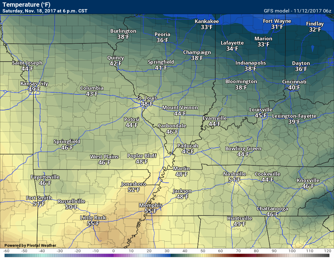
November 18, 2017
Saturday Forecast Details
Forecast: Partly cloudy and cooler. Breezy. Isolated showers may remain.
Temperatures: MO ~ 54 to 58 IL ~ 54 to 58 KY ~ 54 to 58
Wind chill values: N/A
Snow or ice: No
Winds: North and northwest at 10 to 20 mph
What impacts are anticipated from the weather? None.
My confidence in the forecast verifying: Medium
Is severe weather expected? No
The NWS defines severe weather as 58 mph wind or great, 1″ hail or larger, and/or tornadoes
Is freezing rain, sleet, or snow expected? No
What is the chance of precipitation? MO ~ 20% IL ~ 20% KY ~ 20%
Coverage of precipitation:
Should I cancel my outdoor plans?
.
Saturday Night Forecast Details:
Forecast: Mostly clear. Patchy fog possible.
Temperatures: MO ~ 30 to 35 IL ~ 30 to 35 KY ~ 30 to 35
Wind chill values: N/A
Snow or ice: No
Winds: North winds at 4 to 8 mph
What impacts are anticipated from the weather? Patchy fog.
My confidence in the forecast verifying: Medium
Is severe weather expected? No
The NWS defines severe weather as 58 mph wind or great, 1″ hail or larger, and/or tornadoes
Is freezing rain, sleet, or snow expected? No
What is the chance of precipitation? MO ~ 0% IL ~ 0% KY ~ 0%
Coverage of precipitation: None
Should I cancel my outdoor plans: No
.
The degree of cloud cover on Monday is questionable. If we are lucky we will clear our faster.
.

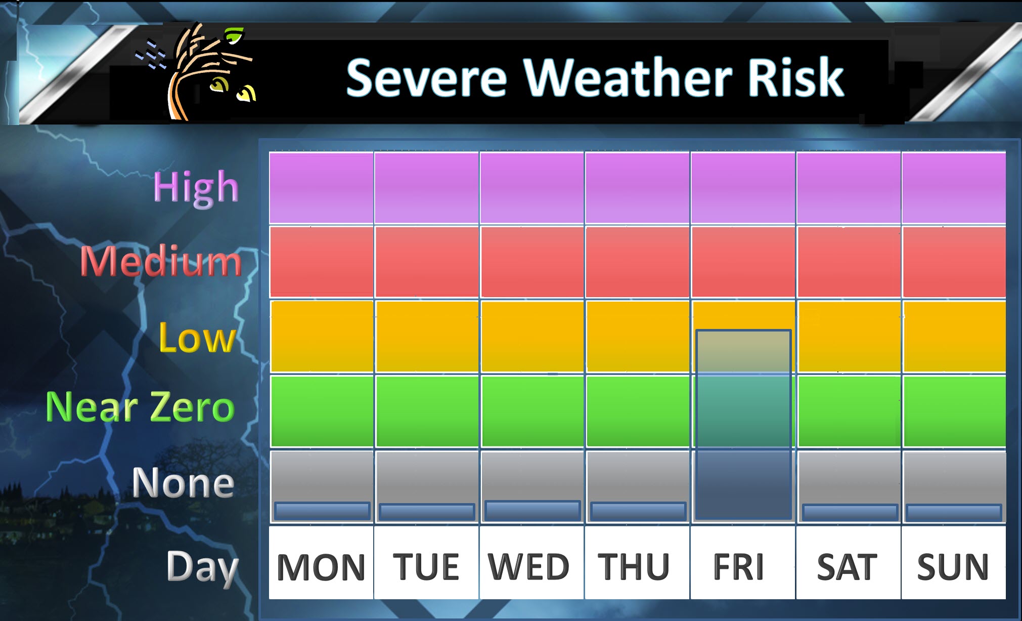
The National Weather Service definition of a severe thunderstorm is one that produces quarter size hail or larger, 58 mph winds or greater, and/or a tornado.
Sunday night through Thursday: Severe weather is not anticipated. Lightning is possible Tuesday night and Wednesday.
Friday and Saturday: I am monitoring a storm system that could bring thunderstorms into the region. At this time, the threat for severe weather is an unknown. Monitor updates. The time frame would likely be Friday or Friday night.
Weekly Severe Weather Outlook. Friday has been marked with a risk.
.

Sunday night through Saturday: Widespread/accumulating wintry precipitation is not anticipated.
.

Weather Highlights:
The main weather story over the coming days will be three cold fronts.
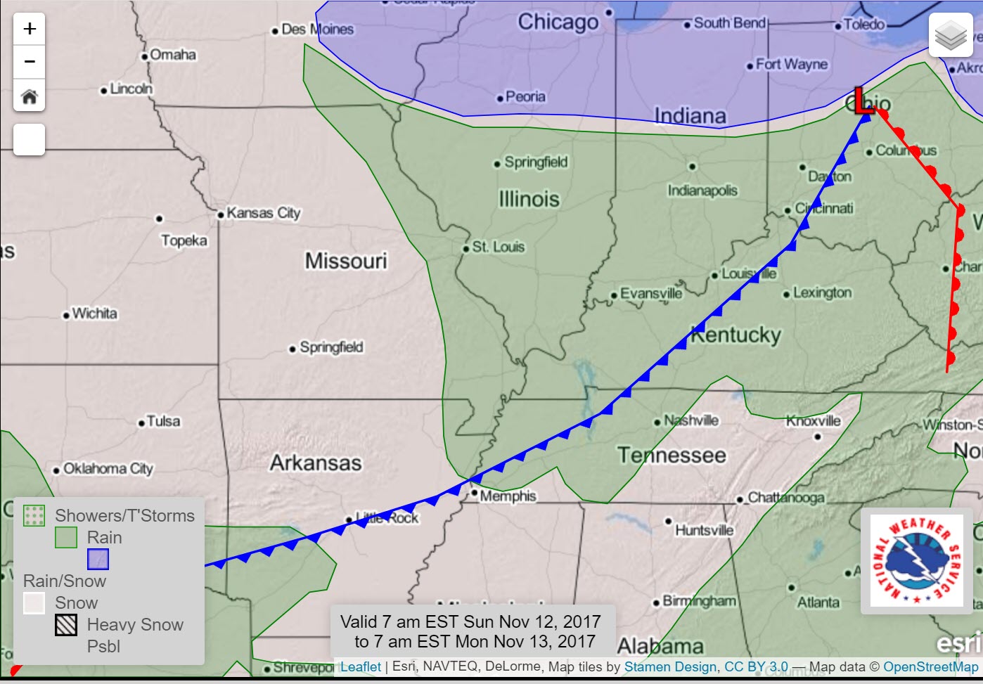
One of those fronts passed through the region today. It was responsible for the light showers that have dotted radar since earlier this morning.
I don’t believe you will see much change in temperatures behind today’s cold front. We will remain on the cool side for several days. No extremes are forecast.
Here is the front that passed through the region today.
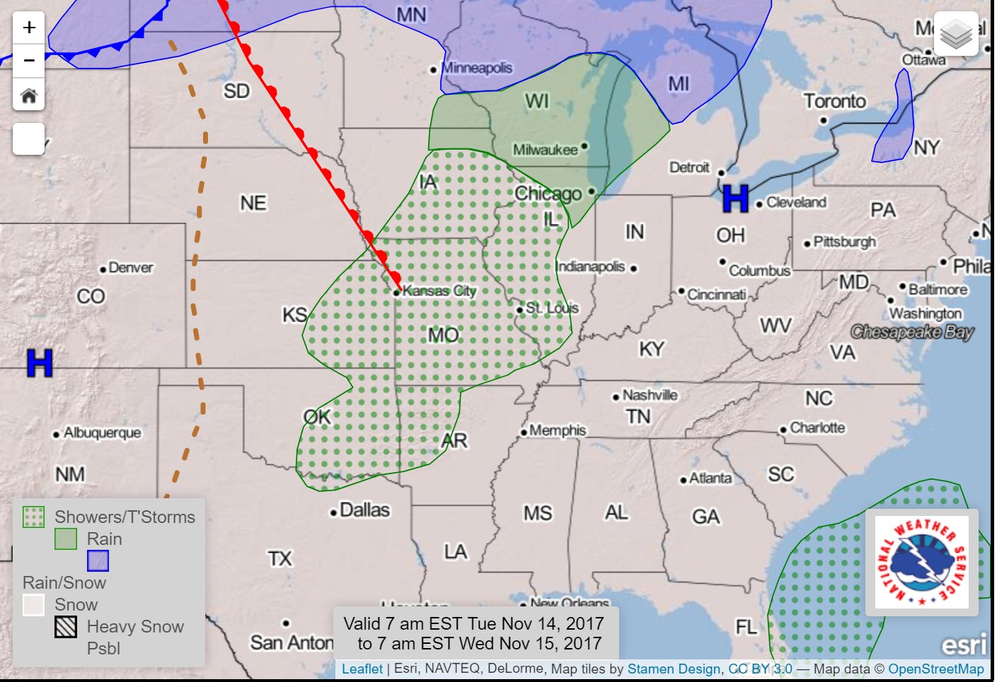
Another cold front will push into the region on Tuesday night and Wednesday. The front will be accompanied by a few showers and thunderstorms.
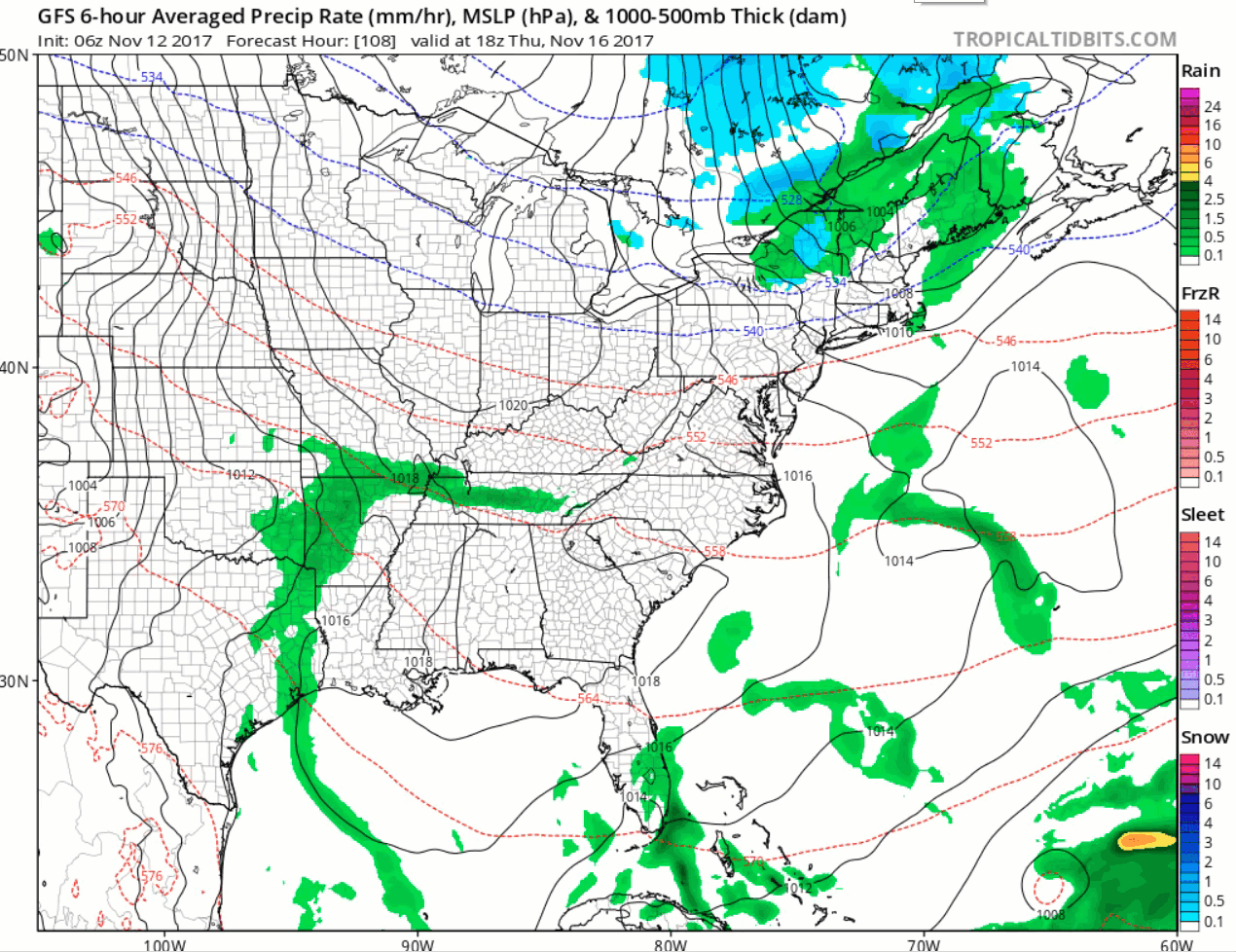
Here is the Tuesday night weather map. You can see the outline for spotty rain showers. This will all push eastward into the overnight hours. The rain will expand into our region Tuesday night/Wednesday.
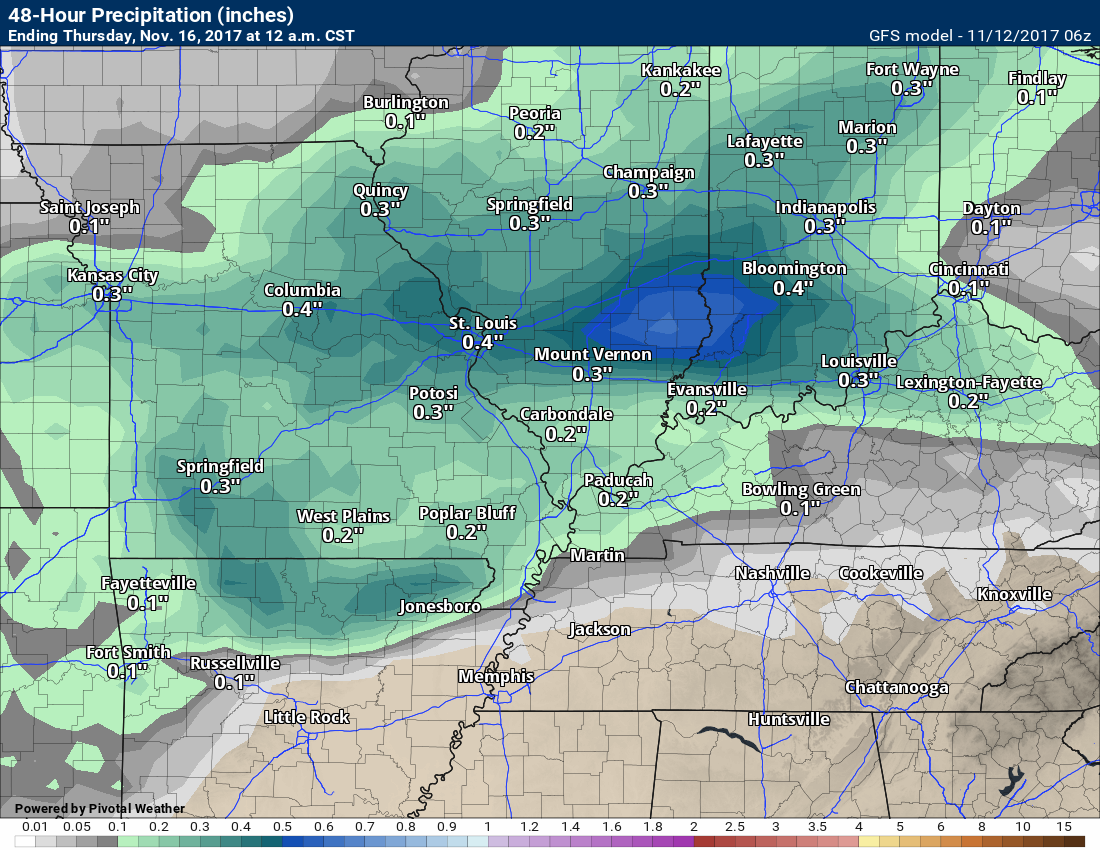
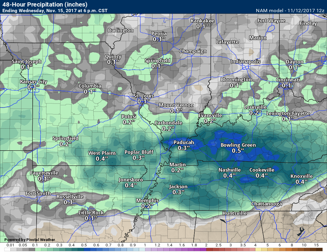
Let’s look at the NAM model guidance future-cast radar. It shows a few showers late Tuesday afternoon. I believe most of the showers will hold off until Tuesday night/Wednesday morning.
Time stamp is on the top left
Click image to enlarge
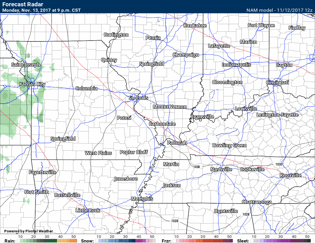
There could be a rumble of thunder Tuesday night into Wednesday. Severe weather is not in the cards.
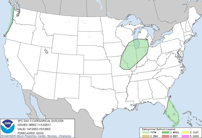
The Storm Prediction Center has outlined a general risk zone for storms on Tuesday night/Wednesday. General is a level 0 out of 5 risk. That means a non-severe weather risk. Lightning would be possible. You could probably shift this further south, as well.
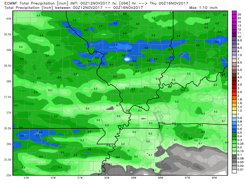
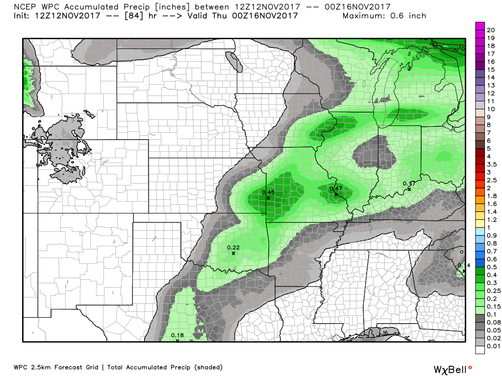
As far as rainfall totals with the Tuesday/Wednesday event.
Here is my forecast.
Probabilities favor a low end rain event.
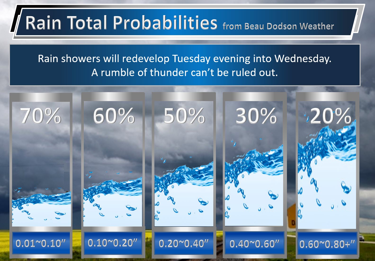
GFS model
Canadian model

NAM model
EC model
NOAA forecast
Late Week Storm System.
A stronger storm system will take shape by late in the week. This system will wind itself up and push into the Great Lakes. A deep area of low pressure will move across portions of Iowa and then northeast into Wisconsin. The low will tighten the pressure gradient over our region. This will mean strong and gusty winds.
A band of showers and thunderstorms will accompany the front. I am monitoring the risk for severe weather. It is a bit early to know if severe weather will be a concern.
The models differ on the timing of the cold front. Keep that in mind. The timing will need to be fine tuned.
The front may not arrive until Friday afternoon or night. Low confidence.
You can see that system here on the GFS model guidance.
Deep low over Wisconsin. Notice the black lines. Those are isobars. Equal lines of pressure. The tighter they are the greater the chance of gusts winds.
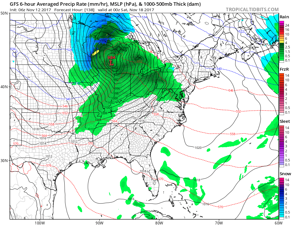
Here is the animation of that system. Thursday night into Friday night.
Notice the low take shape over Iowa and then push northeast. A band of rain and storms form along the front. Blue would be snow.
Time stamp is in zulu hours. 00z would be 6 p.m. 12z would be 6 a.m.
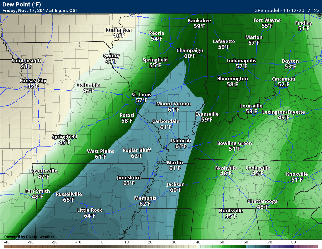
Dew points ahead of the system will likely rise into the 50’s and perhaps 60’s. Typically severe weather normally requires dew points in the upper 50’s and especially the 60’s. Model guidance indicates we may see those numbers, but confidence isn’t all that great (at least for now). Monitor updates concerning the late week system.
Let’s look at a few maps
The dew point map on Friday shows a tongue of upper 50’s to lower 60’s across Missouri. This will push east with time.
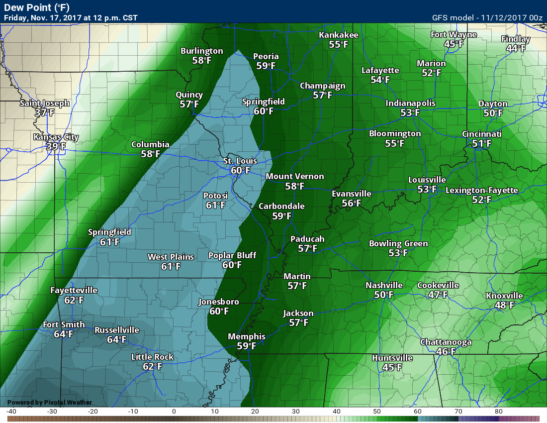
Friday 6 p.m.
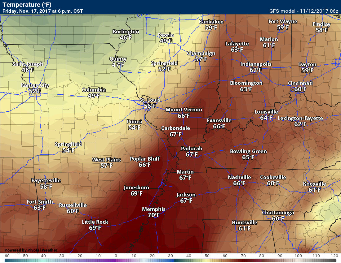
Temperatures will be warm for November. Friday 12 p.m., temperatures.

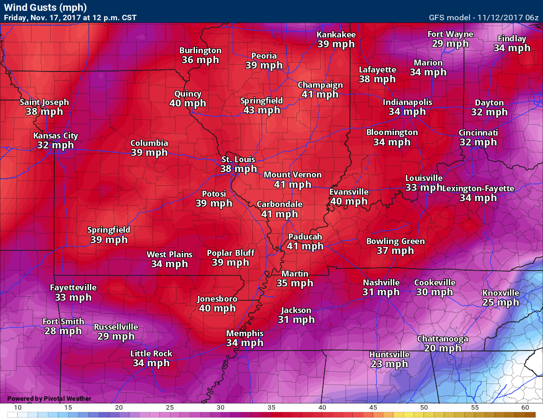
Winds will be gusty. You can expect gusts above 30 mph with this system. This map is for Friday at 12 p.m.
PWAT values are high. This is a measure of moisture in the entire atmospheric column. These numbers are fairly high for the Month of November

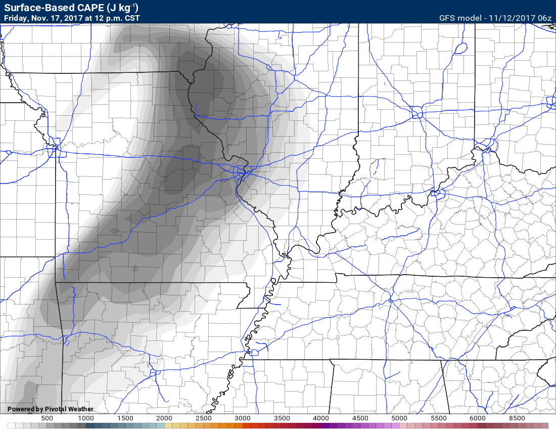
CAPE values are not all that impressive, but in November it only take 100 to 300 joules for there to be issues. It isn’t like spring or summer.
The overall severe weather risk remains questionable. Let’s keep an eye on it.
Here is what the Storm Prediction Center said about the Friday event.
Begin
With modest moisture return expected to occur ahead of the system,
sufficient CAPE appears likely to exist for at least a somewhat
organized low-topped forced-line of convection along the front.
Given very strong flow at low to mid levels, gusty/locally damaging
winds may accompany the line of storms, presuming enough instability
in place to support a reasonably solid/intense frontal band.
Given the timing differences between the models and likelihood that
— in any case — the available CAPE will be modest, highlighting a
risk area appears a bit premature at this time. However, if
subsequent model runs become slightly more aligned timing-wise,
introduction of a 15% area may be required — possibly as early as
the next medium-range forecast package.
End
It will be cooler behind the cold front. Guidance varies on the degree of cold.
Here is the 6 pm Friday temperature map compared to 6 pm Saturday. No extreme cold, but it will be colder.
and Saturday at 6 pm
Are you subscribing to Weather Talk app/text messages and videos? This is what helps support all of the data you see each day.
We now offer premium videos for the short and long-range forecasts! These videos are produced by a team of long-range forecast experts. They are brought to you as bonus information. Activate text option four in order to receive these on your app or via text.
Subscribe at www.beaudodsonweather.com
We offer an Apple and Android app (scroll to the bottom of this page for more information).

Were you aware that I hired a team of meteorologists for long range videos?
To learn more, click this link
http://cms.weathertalk.com/meet-the-team/
.


We offer regional radars and local city radars – if a radar does not update then try another one. Occasional browsers need their cache cleared. You may also try restarting your browser. This will usually fix any problems.
During the winter you can track snow and ice by clicking the winterize button on the local city view interactive radars.
You may email me at beaudodson@usawx.com
Interactive Weather Radar Page. Choose the city nearest your location: Click this link
National interactive radar: Click this link.
The Beau Dodson Weather APP is ready for Apple and Android users. The app provides a faster way for you to receive my text messages. ATT and Verizon are not always reliable when it comes to speed.
Some of you have asked if you can receive the texts on your phone and the app. The answer to that is, yes. The Android app will automatically allow that to happen. On the Apple app, however, you will need to open your app and click the settings button. Make sure the green tab is OFF. Off means you will still receive the texts to your phone and the app. If you have any questions, then email me at beaudodson@usawx.com
The app is for text subscribers.
The direct download, for the Apple app, can be viewed here
https://itunes.apple.com/us/app/id1190136514
Here is the download link for the Android version Click Here
If you have not signed up for the texting service then you may do so at www.beaudodsonweather.com


——————————————————–
Your support helps with the following:

and

.

Whom do you trust for your weather information?
I have studied weather, in our region, since the late 1970’s. I have 40 years of experience in observing our regions weather patterns. My degree is in Broadcast Meteorology and a Bachelor’s of Science.
My resume includes:
Member of the American Meteorological Society.
NOAA Weather-Ready Nation Ambassador.
Meteorologist for McCracken County Emergency Management. I served from 2005 through 2015.
Meteorologist for McCracken County Rescue. 2015 through current
I own and operate the Southern Illinois Weather Observatory.
I am the chief meteorologist for Weather Talk LLC.
I am also a business owner in western Kentucky.
Recipient of the Mark Trail Award, WPSD Six Who Make A Difference Award, Kentucky Colonel, and the Caesar J. Fiamma” Award from the American Red Cross.
In 2005, I helped open the largest American Cross shelter in U.S. history. This was in Houston, Texas. I was deployed to help with the aftermath of Hurricane Katrina and Hurricane Rita. I was a shelter manager of one of the Houston, Texas shelter divisions.
In 2009 I was presented with the Kentucky Office of Highway Safety Award.
Recognized by the Kentucky House of Representatives for my service to the State of Kentucky leading up to several winter storms and severe weather outbreaks.
If you click on the image below you can read the Kentucky House of Representatives Resolution.

I am President of the Shadow Angel Foundation which serves portions of western Kentucky and southern Illinois.
There is a lot of noise on the internet. A lot of weather maps are posted without explanation. You need a trusted source for information.
My forecast philosophy is simple and straight forward.
- Communicate in simple terms
- To be as accurate as possible within a reasonable time frame before an event
- Interact with you on Twitter, Facebook, email, texts, and this blog
- Minimize the “hype” that you might see through other weather sources
- Push you towards utilizing wall-to-wall LOCAL TV coverage during severe weather events

Sign up for my AWARE email by clicking here.
I typically send AWARE emails before severe weather, winter storms, or other active weather situations. I do not email watches or warnings. The emails are a basic “heads up” concerning incoming weather conditions