

.
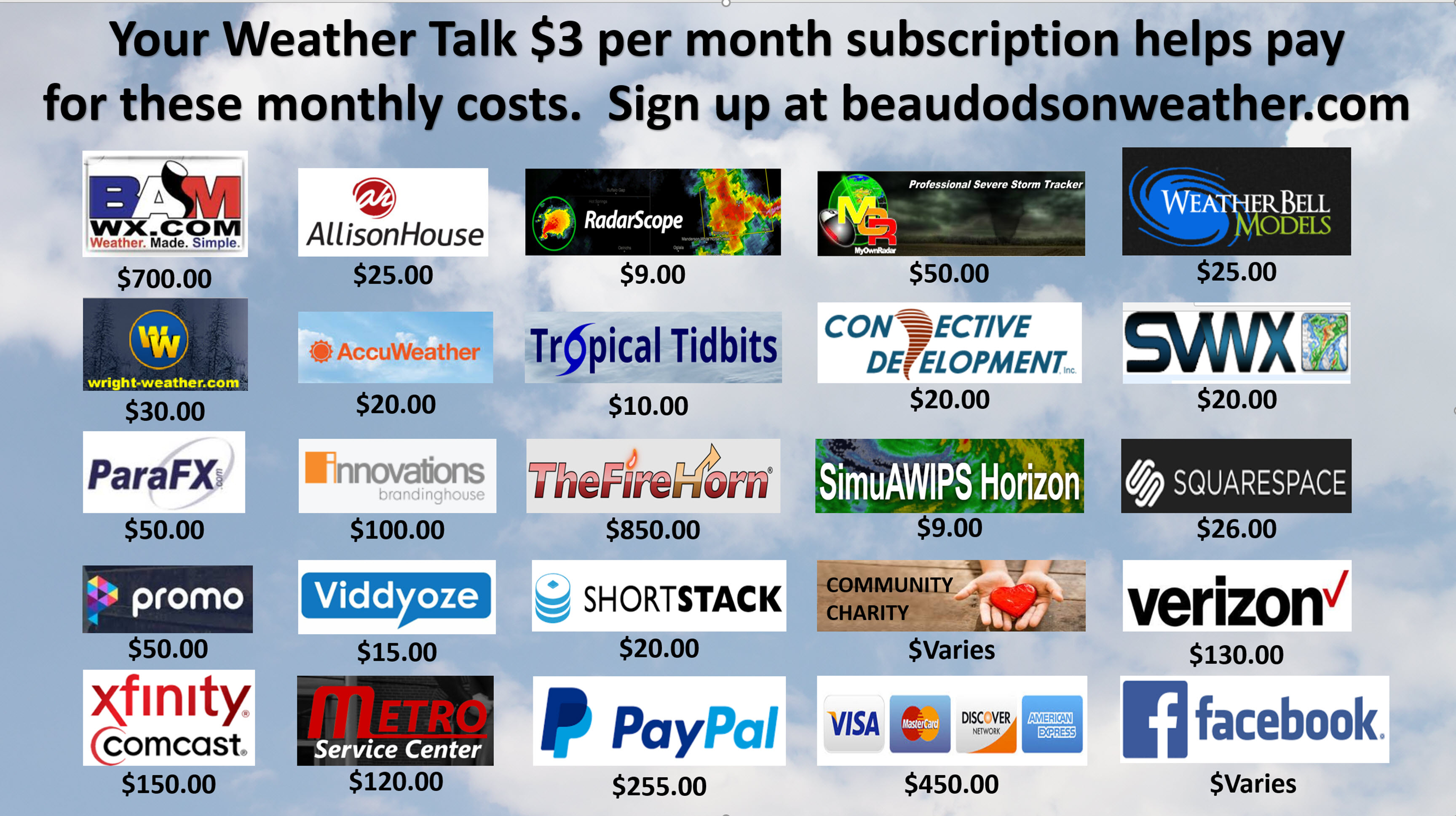
A Weather Talk subscription ($3 a month) is required to view the videos. This helps cover monthly costs (which can run between one and two thousand dollars).
Videos are posted on the www.weathertalk.com website. Once there, click the Beau Video-Cast tab. Long Range Video Update
If you believe you missed a video then you may check the LIVE FEED link on the Weather Talk website. You will find an archive of videos on that page.
You can also receive the videos via your Weather Talk app/text messages. Turn text option FOUR to the on position. The Weather Extra text option. Sign up for the app/text messages, videos, and more at www.beaudodsonweather.com
Your $3 a month helps cover the following monthly costs. These are my out of pocket expenses.
This forecast covers the counties in red. The counties in orange are covered by the forecast discussion further down in the blog.


November 10, 2017
Friday Night Forecast Details:
Forecast: Clear and cold. Fog possible.
Temperatures: MO ~ 23 to 26 IL ~ 22 to 26 KY ~ 24 to 28
Wind chill values: Mainly in the 20’s.
Snow or ice: No
Winds: East and northeast 7 to 14 mph
What impacts are anticipated from the weather? Perhaps patchy fog.
My confidence in the forecast verifying: High
Is severe weather expected? No
The NWS defines severe weather as 58 mph wind or great, 1″ hail or larger, and/or tornadoes
Is freezing rain, sleet, or snow expected? No
What is the chance of precipitation? MO ~ 0% IL ~ 0% KY ~ 0%
Coverage of precipitation: None anticipated
Should I cancel my outdoor plans: No
.
November 11, 2017
Veterans Day
Saturday Forecast Details
Forecast: Mostly sunny. Some passing clouds likely, as well. Warmer.
Temperatures: MO ~ 54 to 56 IL ~ 52 to 56 KY ~ 55 to 58
Wind chill values: N/A
Snow or ice: No
Winds: East/southeast at 5 to 10 mph. Gusts to 12 mph
What impacts are anticipated from the weather? None
My confidence in the forecast verifying: High
Is severe weather expected? No
The NWS defines severe weather as 58 mph wind or great, 1″ hail or larger, and/or tornadoes
Is freezing rain, sleet, or snow expected? No
What is the chance of precipitation? MO ~ 0% IL ~ 0% KY ~ 0%
Coverage of precipitation: None
Should I cancel my outdoor plans? No
.
Saturday Night Forecast Details:
Forecast: Cloudy. A few rain showers after midnight. Light rain totals. Some areas will remain dry.
Temperatures: MO ~ 42 to 46 IL ~ 40 to 45 KY ~ 40 to 45
Wind chill values: N/A
Snow or ice: No
Winds: South winds 5 to 10 mph.
What impacts are anticipated from the weather? Wet roadways late.
My confidence in the forecast verifying: High
Is severe weather expected? No
The NWS defines severe weather as 58 mph wind or great, 1″ hail or larger, and/or tornadoes
Is freezing rain, sleet, or snow expected? No
What is the chance of precipitation? MO ~ 50% IL ~ 50% KY ~ 40%
Coverage of precipitation: Some showers after 12 am mainly over the northern portion of the region. Rain will be moving south/southeast.
Should I cancel my outdoor plans: No.
.
November 12, 2017
Sunday Forecast Details
Forecast: Cloudy with scattered morning light rain showers. Greatest rain coverage will be before 12 p.m. Many areas will miss out on the rain.
Temperatures: MO ~ 52 to 56 IL ~ 52 to 56 KY ~ 52 to 56
Wind chill values: N/A
Snow or ice: No
Winds: South winds becoming southwest. Winds will become west and northwest behind the cold front.
What impacts are anticipated from the weather? Wet roadways
My confidence in the forecast verifying: Medium
Is severe weather expected? No
The NWS defines severe weather as 58 mph wind or great, 1″ hail or larger, and/or tornadoes
Is freezing rain, sleet, or snow expected? No
What is the chance of precipitation? MO ~ 50% IL ~ 50% KY ~ 50%
Coverage of precipitation: Perhaps numerous.
Should I cancel my outdoor plans? No, but I would suggest you monitor radars. There will be rain showers in the region.
.
Sunday Night Forecast Details:
Forecast: Cloudy. Any remaining showers will have ended. Cool temperatures.
Temperatures: MO ~ 33 to 36 IL ~ 32 to 36 KY ~ 34 to 38
Wind chill values: N/A
Snow or ice: No
Winds: North and northwest 5 to 10 mph with gusts to 14 mph
What impacts are anticipated from the weather? Most likely none.
My confidence in the forecast verifying: High
Is severe weather expected? No
The NWS defines severe weather as 58 mph wind or great, 1″ hail or larger, and/or tornadoes
Is freezing rain, sleet, or snow expected? No
What is the chance of precipitation? MO ~ 10% IL ~ 10% KY ~ 20%
Coverage of precipitation: None. Rain ending.
Should I cancel my outdoor plans: No, but check radars early in the evening. The rain should have ended.
.
November 13, 2017
Monday Forecast Details
Forecast: A mix of sun and clouds. Lower than normal confidence on the cloud cover. Sometimes clouds are stubborn to leave during the Month of November.
Temperatures: MO ~ 52 to 56 IL ~ 52 to 56 KY ~ 53 to 56
Wind chill values: N/A
Snow or ice: No
Winds: North and northeast at 5 to 10 mph. Gusts to 14 mph possible during the morning.
What impacts are anticipated from the weather? None
My confidence in the forecast verifying: High
Is severe weather expected? No
The NWS defines severe weather as 58 mph wind or great, 1″ hail or larger, and/or tornadoes
Is freezing rain, sleet, or snow expected? No
What is the chance of precipitation? MO ~ 0% IL ~ 0% KY ~ 0%
Coverage of precipitation: None
Should I cancel my outdoor plans? No
.
Monday Night Forecast Details:
Forecast: Mostly clear. Chilly. Patchy fog possible.
Temperatures: MO ~ 30 to 35 IL ~ 30 to 35 KY ~ 32 to 35
Wind chill values: N/A
Snow or ice: No
Winds: East and northeast 3 to 6 mph
What impacts are anticipated from the weather? Patchy fog.
My confidence in the forecast verifying: High
Is severe weather expected? No
The NWS defines severe weather as 58 mph wind or great, 1″ hail or larger, and/or tornadoes
Is freezing rain, sleet, or snow expected? No
What is the chance of precipitation? MO ~ 0% IL ~ 0% KY ~ 0%
Coverage of precipitation: None
Should I cancel my outdoor plans: No
.
November 14, 2017
Tuesday Forecast Details
Forecast: Mostly sunny. Clouds may be on the increase during the afternoon. A small chance of showers towards evening over southeast Missouri.
Temperatures: MO ~ 56 to 62 IL ~ 56 to 62 KY ~ 56 to 62
Wind chill values: N/A
Snow or ice: No
Winds: East and southeast 5 to 10 mph
What impacts are anticipated from the weather? None
My confidence in the forecast verifying: High
Is severe weather expected? No
The NWS defines severe weather as 58 mph wind or great, 1″ hail or larger, and/or tornadoes
Is freezing rain, sleet, or snow expected? No
What is the chance of precipitation? MO ~ 20% IL ~ 10% KY ~ 10%
Coverage of precipitation: None to isolated.
Should I cancel my outdoor plans? No
.
Tuesday Night Forecast Details:
Forecast: Clouds thickening. Shower chances will be on the increase. Thunderstorms are possible.
Temperatures: MO ~ 40 to 45 IL ~ 40 to 45 KY ~ 40 to 45
Wind chill values: N/A
Snow or ice: No
Winds: South and southeast winds increasing to 8 to 16 mph
What impacts are anticipated from the weather? Wet roadways. Lightning.
My confidence in the forecast verifying: High
Is severe weather expected? No
The NWS defines severe weather as 58 mph wind or great, 1″ hail or larger, and/or tornadoes
Is freezing rain, sleet, or snow expected? No
What is the chance of precipitation? MO ~ 60% IL ~ 60% KY ~ 50%
Coverage of precipitation: Scattered to perhaps numerous
Should I cancel my outdoor plans: No, but check radars
.
November 15, 2017
Wednesday Forecast Details
Forecast: Cloudy. Showers likely. A thunderstorm possible.
Temperatures: MO ~ 55 to 60 IL ~ 55 to 60 KY ~ 55 to 60
Wind chill values: N/A
Snow or ice: No
Winds: South and southwest at 5 to 10 mph. Winds shifting to west in the afternoon.
What impacts are anticipated from the weather? Wet roadways
My confidence in the forecast verifying: High
Is severe weather expected? No
The NWS defines severe weather as 58 mph wind or great, 1″ hail or larger, and/or tornadoes
Is freezing rain, sleet, or snow expected? No
What is the chance of precipitation? MO ~ 60% IL ~ 60% KY ~ 60%
Coverage of precipitation: Numerous
Should I cancel my outdoor plans? Check updates and radars
.
Wednesday Night Forecast Details:
Forecast: Evening clouds. Isolated showers. I believe most of the rain will have ended. Cool temperatures. If we clear out then fog would be possible.
Temperatures: MO ~ 42 to 46 IL ~ 42 to 46 KY ~ 42 to 46
Wind chill values: N/A
Snow or ice: No
Winds: West and northwest at 3 to 6 mph
What impacts are anticipated from the weather? Perhaps wet roadways early
My confidence in the forecast verifying: Medium
Is severe weather expected? No
The NWS defines severe weather as 58 mph wind or great, 1″ hail or larger, and/or tornadoes
Is freezing rain, sleet, or snow expected? No
What is the chance of precipitation? MO ~ 20% IL ~ 20% KY ~ 20%
Coverage of precipitation: None to isolated. Ending.
Should I cancel my outdoor plans: No
.
November 16, 2017
Thursday Forecast Details
Forecast: Partly sunny. Warmer.
Temperatures: MO ~ 58 to 64 IL ~ 58 to 64 KY ~ 58 to 64
Wind chill values: N/A
Snow or ice: No
Winds: East becoming southeast at 7 to 14 mph.
What impacts are anticipated from the weather? None
My confidence in the forecast verifying: High
Is severe weather expected? No
The NWS defines severe weather as 58 mph wind or great, 1″ hail or larger, and/or tornadoes
Is freezing rain, sleet, or snow expected? No
What is the chance of precipitation? MO ~ 10% IL ~ 10% KY ~ 10%
Coverage of precipitation: None to isolated.
Should I cancel my outdoor plans? No
.
Thursday Night Forecast Details:
Forecast: Cloudy. A chance of showers. A thunderstorm possible. Temperatures may hold steady or rise.
Temperatures: MO ~ 46 to 52+ IL ~ 46 to 52+ KY ~ 46 to 52+
Wind chill values: N/A
Snow or ice: No
Winds: East and southeast winds becoming south/southeast at 10 to 20 mph.
What impacts are anticipated from the weather? Wet roadways. Lightning.
My confidence in the forecast verifying: Medium
Is severe weather expected? No
The NWS defines severe weather as 58 mph wind or great, 1″ hail or larger, and/or tornadoes
Is freezing rain, sleet, or snow expected? No
What is the chance of precipitation? MO ~ 50% IL ~ 50% KY ~ 50%
Coverage of precipitation: Scattered to perhaps numerous
Should I cancel my outdoor plans: No, but monitor updates
.
November 17, 2017
Friday Forecast Details
Forecast: Showers and thunderstorms likely. Gusty winds. Mild ahead of the cold front.
Temperatures: MO ~ 64 to 68 IL ~ 64 to 68 KY ~ 64 to 68
Wind chill values: N/A
Snow or ice: No
Winds: South and southwest winds 15 to 30 mph. Gusty.
What impacts are anticipated from the weather? Wet roadways. Lightning.
My confidence in the forecast verifying: Medium
Is severe weather expected? Maybe. Monitor updates.
The NWS defines severe weather as 58 mph wind or great, 1″ hail or larger, and/or tornadoes
Is freezing rain, sleet, or snow expected? No
What is the chance of precipitation? MO ~ 70% IL ~ 70% KY ~ 70%
Coverage of precipitation: Numerous
Should I cancel my outdoor plans? Monitor radars and updates.
.
Friday Night Forecast Details:
Forecast: Cloudy. Breezy. Cooler. A chance of evening showers and thunderstorms. Timing of the cold front will be key to Friday night rain chances. If the front moves through fast enough then rain chances will be lower. Timing of the front is still questionable.
Temperatures: MO ~ 40 to 45 IL ~ 40 to 45 KY ~ 42 to 46
Wind chill values: N/A
Snow or ice: No
Winds: Becoming west and northwest at 15 to 25 mph. Gusty.
What impacts are anticipated from the weather? Wet roadways. Gusty winds.
My confidence in the forecast verifying: Medium
Is severe weather expected? Monitor updates
The NWS defines severe weather as 58 mph wind or great, 1″ hail or larger, and/or tornadoes
Is freezing rain, sleet, or snow expected? No
What is the chance of precipitation? MO ~ 50% IL ~ 60% KY ~ 60%
Coverage of precipitation: Tapering from west to east
Should I cancel my outdoor plans: I would monitor updates and radars
Saturday and Sunday should be dry and cool. Highs in the 50’s and lows in the 30’s.

The National Weather Service definition of a severe thunderstorm is one that produces quarter size hail or larger, 58 mph winds or greater, and/or a tornado.
Friday night through Wednesday: Severe weather is not anticipated.
.

Friday night through next Friday: Widespread/accumulating wintry precipitation is not anticipated.
.

Weather Highlights:
My updates this week will be a bit shorter. We have had a death in the family. It appears the funeral may not be until late in the week. I will be with family on and off throughout the week. So, be patient with the updates. I will, as always, do my best.
Saturday and Sunday
Saturday will remain dry. It will be cool, but nothing extreme. High temperatures will mostly be in the mid to upper 50’s. I can’t rule out some 60 degree readings.
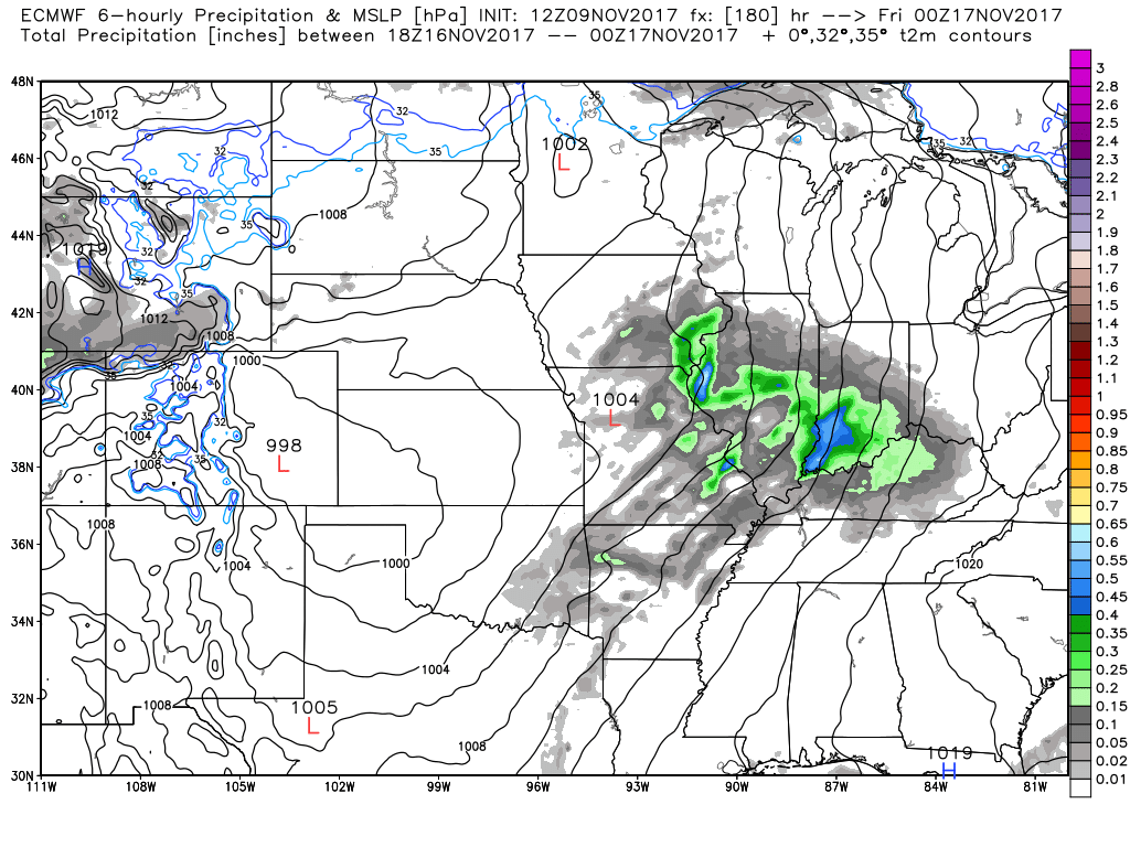
Saturday night and Sunday
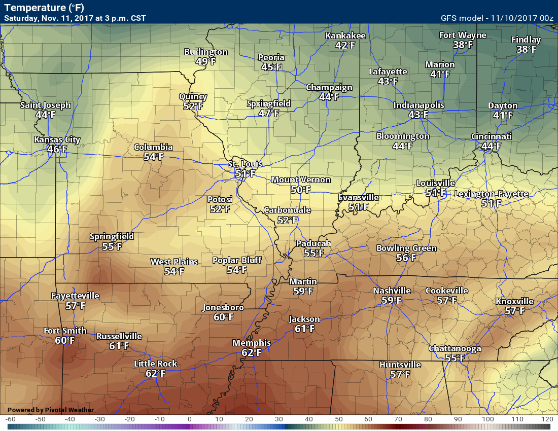
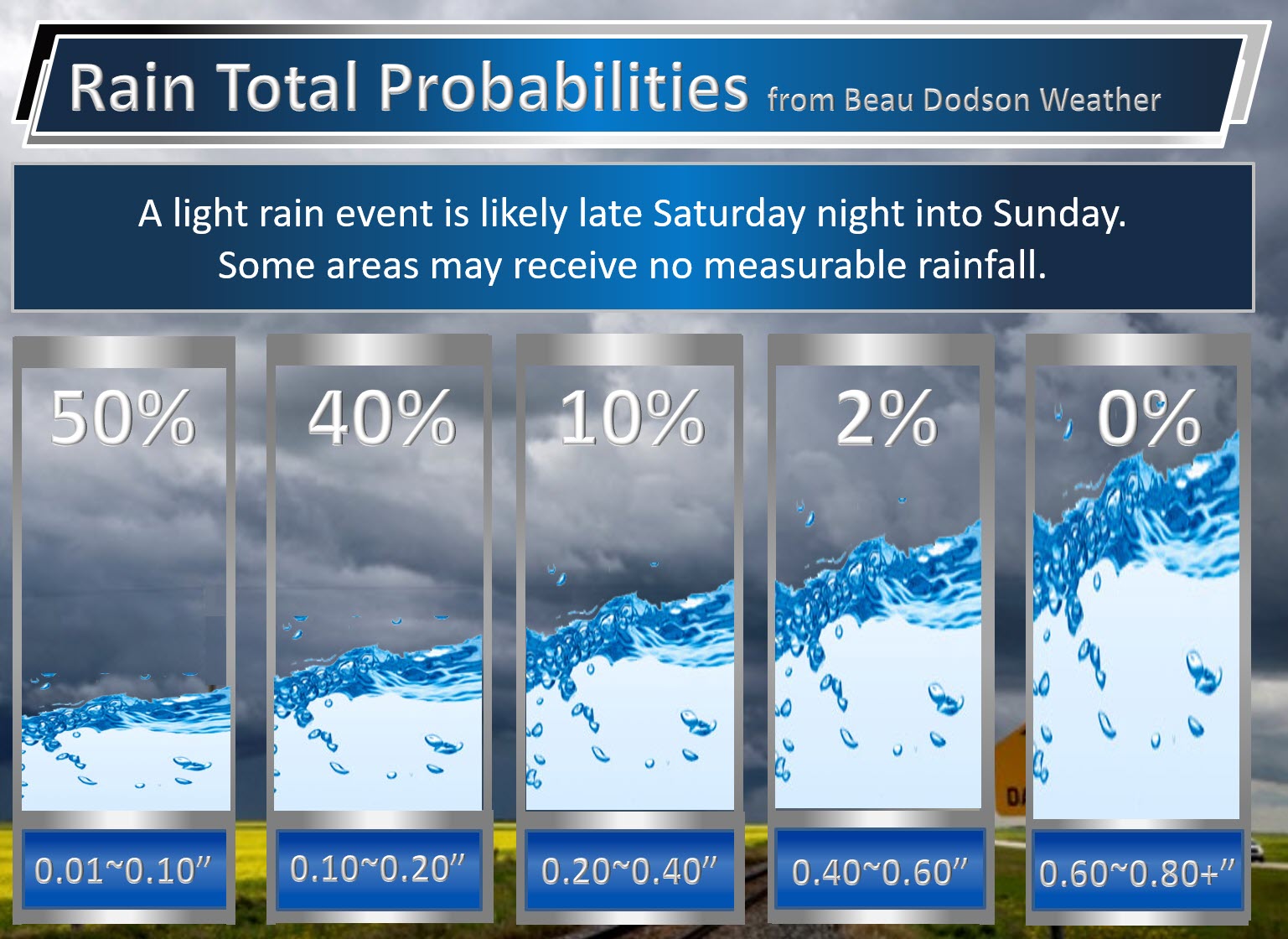
A cold front will approach on Saturday night and Sunday morning. A band of light showers will accompany the front. Rainfall totals late Saturday night and Sunday will likely range from 0.01″ to 0.25″. Not much.
Here is my rainfall forecast.
The bulk of the rain should fall after 2 a.m., on Sunday into the late morning hours. Rain showers will diminish from west to east on Sunday afternoon.
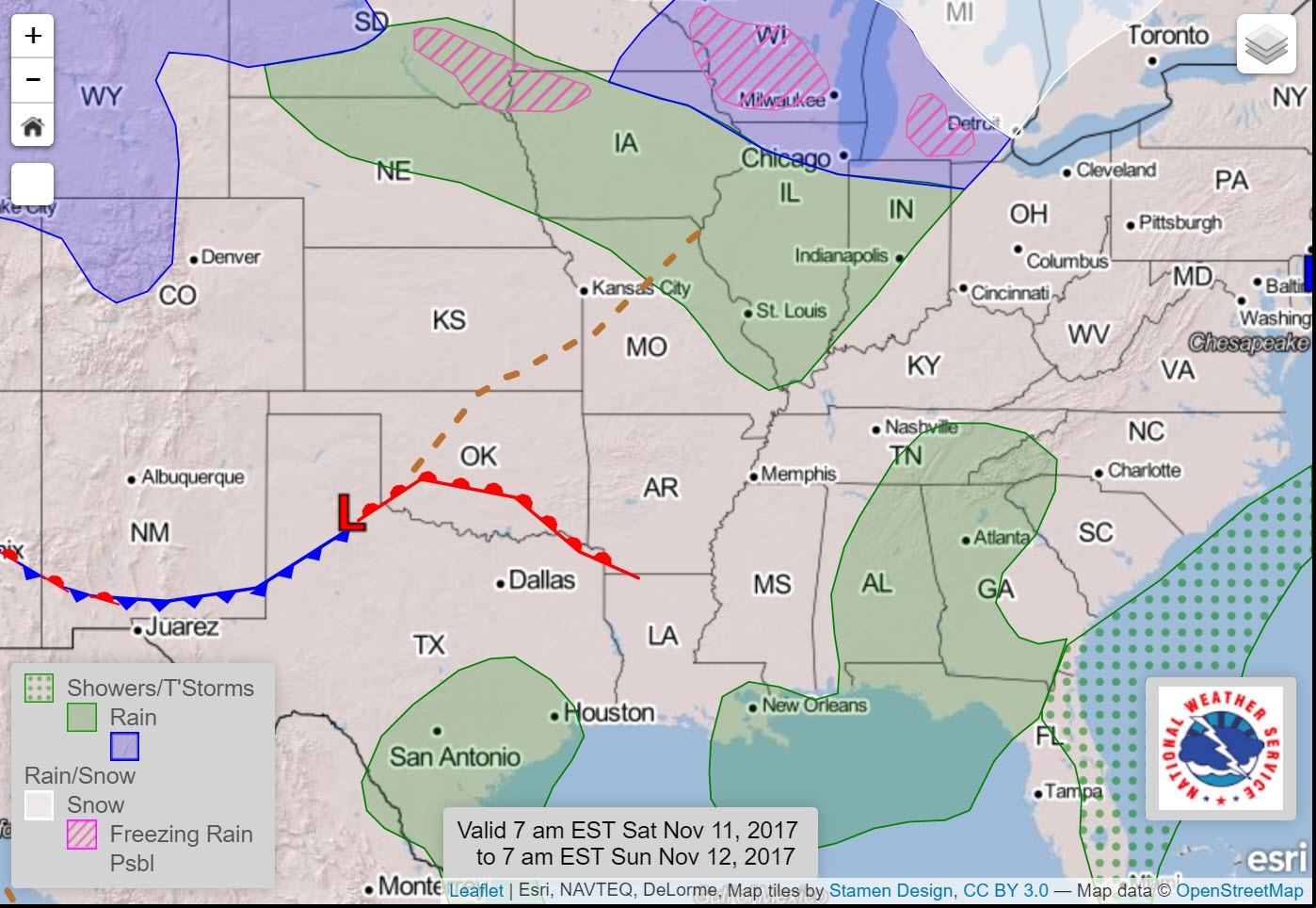
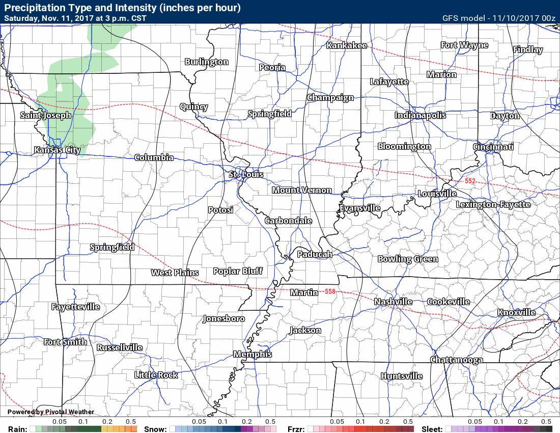
Here is the weather map for late Saturday night into Sunday morning. The greatest chance of rain will be in the green zone.
Here is the GFS future-cast radar for Saturday night/Sunday morning. Time stamp is located on the top left of the image.
Click to enlarge
Monday through Wednesday
Monday and Tuesday will likely remain dry and cool. Another cold front approaches on Tuesday night/Wednesday. A band of light showers will likely accompany that front, as well.
Rainfall totals don’t look all that impressive with this event. Another 0.01″ to 0.25″ appears likely.
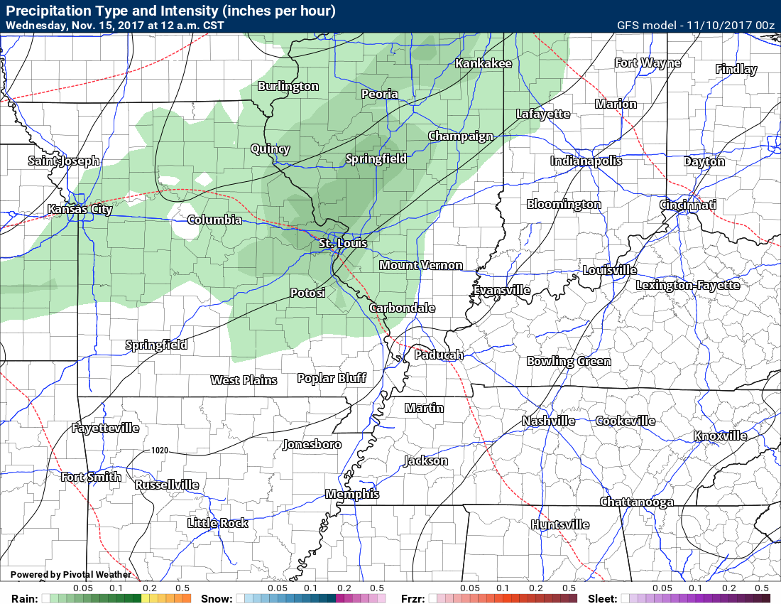
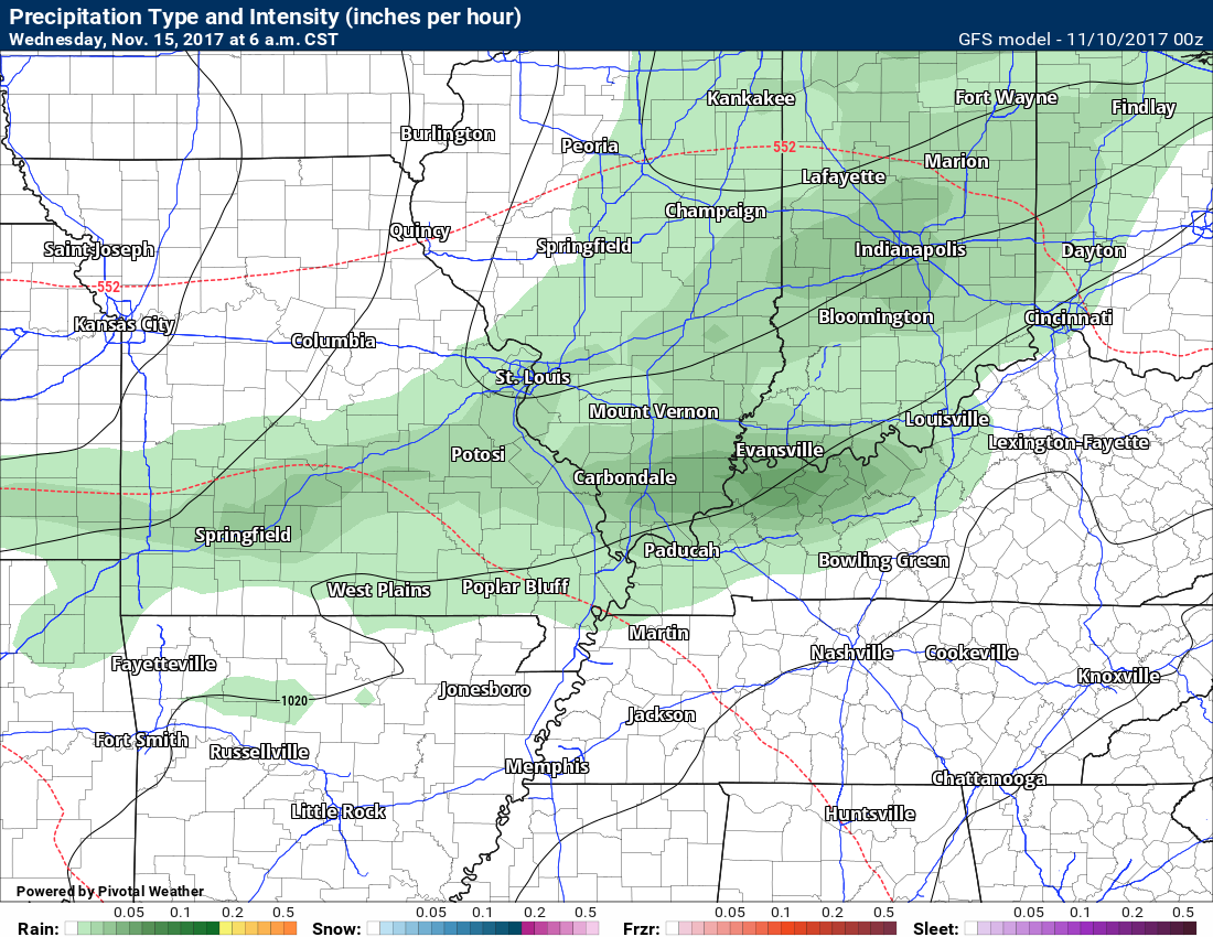
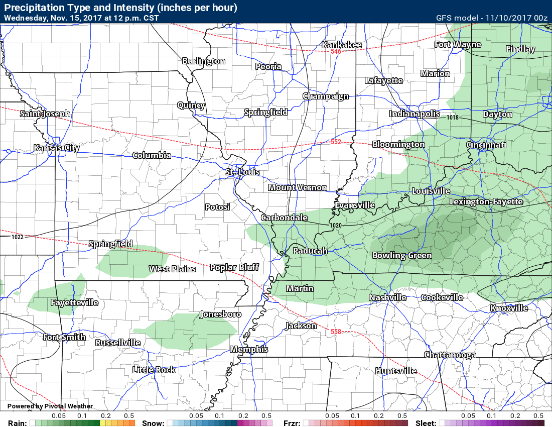
Here is the future-cast radar from the GFS model guidance for the Tuesday night/Wednesday system.
12 a.m. Wednesday
6 a.m. Wednesday
12 p.m. Wednesday
Late next week. Low confidence since it is so far out.
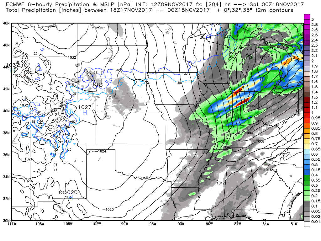
Another system should arrive around November 16th/17th. The GFS has a tight low well to our north. A band of showers and perhaps thunderstorms would move across our region. Windy system. See the black lines? Those are isobars. They are closely packed together. That would mean gusty winds.
The severe weather threat will need to be monitored. This is a strong system.
Here is the future-cast radar for next Friday morning.
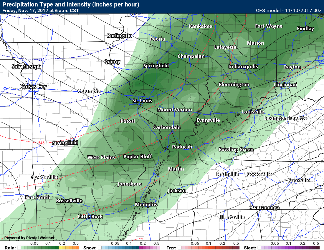
Zoomed out a bit. Check out that tight pressure gradient. If true, that spells strong and gusty winds.
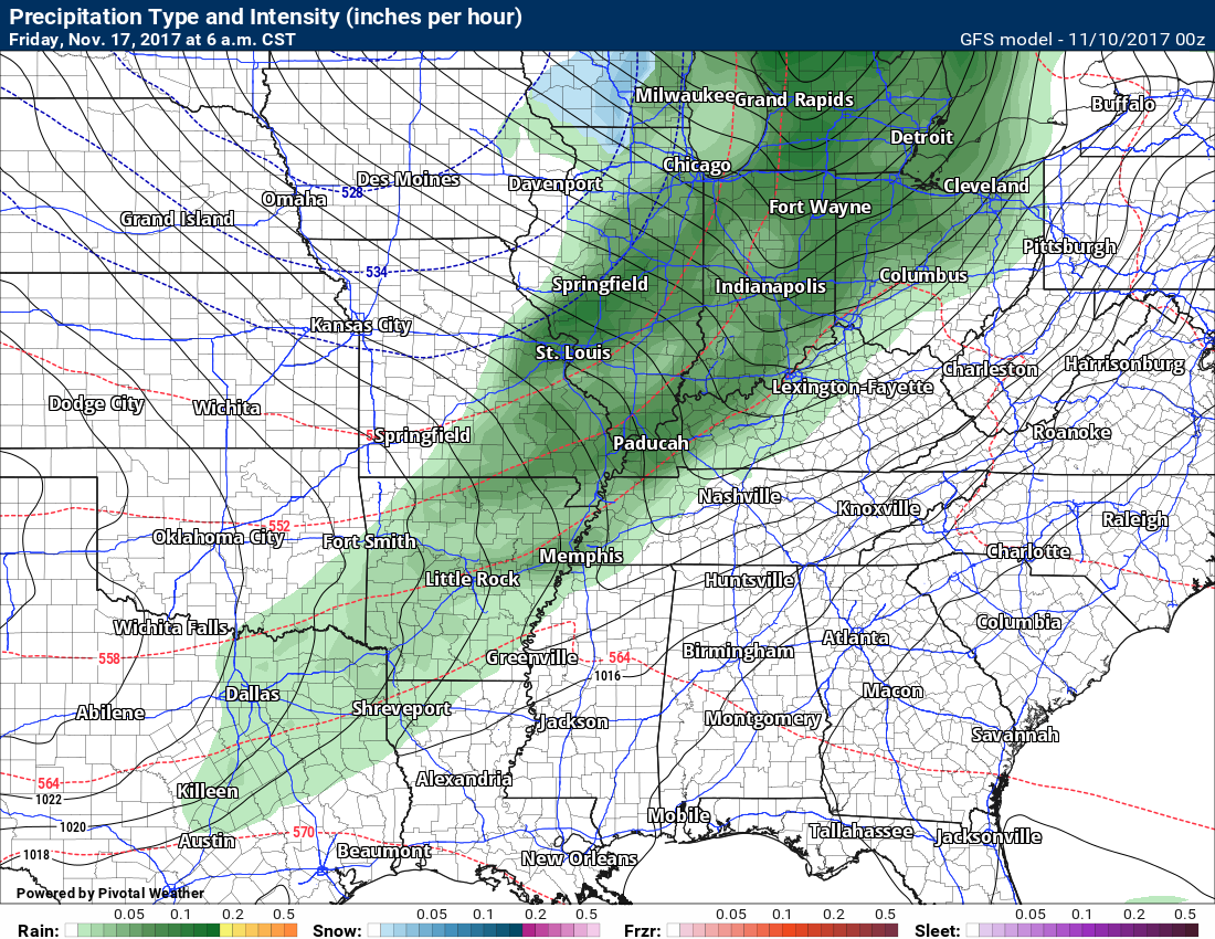
Dew points ahead of that system struggle to make it to 60 degrees. I look for 60 degree dew points when considering severe thunderstorms. At this time, it doesn’t look like dew points would reach that number.
This will, however, need to be monitored. It is a potent system on all of the model guidance packages.

The EC guidance also shows the Friday system, as well. It brings rain into the region on Thursday and Friday.
EC future-cast radar
Thursday 6 p.m.
and here is Friday at 6 p.m.
I will keep an eye on all three systems.
Are you subscribing to Weather Talk app/text messages and videos? This is what helps support all of the data you see each day.
We now offer premium videos for the short and long-range forecasts! These videos are produced by a team of long-range forecast experts. They are brought to you as bonus information. Activate text option four in order to receive these on your app or via text.
Subscribe at www.beaudodsonweather.com
We offer an Apple and Android app (scroll to the bottom of this page for more information).

Were you aware that I hired a team of meteorologists for long range videos?
To learn more, click this link
http://cms.weathertalk.com/meet-the-team/
.


We offer regional radars and local city radars – if a radar does not update then try another one. Occasional browsers need their cache cleared. You may also try restarting your browser. This will usually fix any problems.
During the winter you can track snow and ice by clicking the winterize button on the local city view interactive radars.
You may email me at beaudodson@usawx.com
Interactive Weather Radar Page. Choose the city nearest your location: Click this link
National interactive radar: Click this link.
The Beau Dodson Weather APP is ready for Apple and Android users. The app provides a faster way for you to receive my text messages. ATT and Verizon are not always reliable when it comes to speed.
Some of you have asked if you can receive the texts on your phone and the app. The answer to that is, yes. The Android app will automatically allow that to happen. On the Apple app, however, you will need to open your app and click the settings button. Make sure the green tab is OFF. Off means you will still receive the texts to your phone and the app. If you have any questions, then email me at beaudodson@usawx.com
The app is for text subscribers.
The direct download, for the Apple app, can be viewed here
https://itunes.apple.com/us/app/id1190136514
Here is the download link for the Android version Click Here
If you have not signed up for the texting service then you may do so at www.beaudodsonweather.com


——————————————————–
Your support helps with the following:

and

.

Whom do you trust for your weather information?
I have studied weather, in our region, since the late 1970’s. I have 40 years of experience in observing our regions weather patterns. My degree is in Broadcast Meteorology and a Bachelor’s of Science.
My resume includes:
Member of the American Meteorological Society.
NOAA Weather-Ready Nation Ambassador.
Meteorologist for McCracken County Emergency Management. I served from 2005 through 2015.
Meteorologist for McCracken County Rescue. 2015 through current
I own and operate the Southern Illinois Weather Observatory.
I am the chief meteorologist for Weather Talk LLC.
I am also a business owner in western Kentucky.
Recipient of the Mark Trail Award, WPSD Six Who Make A Difference Award, Kentucky Colonel, and the Caesar J. Fiamma” Award from the American Red Cross.
In 2005, I helped open the largest American Cross shelter in U.S. history. This was in Houston, Texas. I was deployed to help with the aftermath of Hurricane Katrina and Hurricane Rita. I was a shelter manager of one of the Houston, Texas shelter divisions.
In 2009 I was presented with the Kentucky Office of Highway Safety Award.
Recognized by the Kentucky House of Representatives for my service to the State of Kentucky leading up to several winter storms and severe weather outbreaks.
If you click on the image below you can read the Kentucky House of Representatives Resolution.

I am President of the Shadow Angel Foundation which serves portions of western Kentucky and southern Illinois.
There is a lot of noise on the internet. A lot of weather maps are posted without explanation. You need a trusted source for information.
My forecast philosophy is simple and straight forward.
- Communicate in simple terms
- To be as accurate as possible within a reasonable time frame before an event
- Interact with you on Twitter, Facebook, email, texts, and this blog
- Minimize the “hype” that you might see through other weather sources
- Push you towards utilizing wall-to-wall LOCAL TV coverage during severe weather events

Sign up for my AWARE email by clicking here.
I typically send AWARE emails before severe weather, winter storms, or other active weather situations. I do not email watches or warnings. The emails are a basic “heads up” concerning incoming weather conditions