For $5 a month you can receive the following. You may choose to receive these via your WeatherTalk app or regular text messaging.
- Severe weather app/text alerts from my keyboard to your app/cell phone. These are hand typed by Beau. During tornado outbreaks, you will receive numerous app/text messages telling you exactly where the tornado is located.
- Daily forecast app/texts from my computer to your app/cell phone.
- Social media links sent directly to your app/cell phone. When I update the blog, videos, or Facebook you will receive the link.
- AWARE emails. These emails keep you well ahead of the storm. They give you several days of lead time before significant weather events.
- Direct access to Beau via text and email. Your very own personal meteorologist. I work for you!
- Missouri and Ohio Valley centered video updates
- Long-range weather videos
- Week one, two, three and four temperature and precipitation outlooks.
- Monthly outlooks.
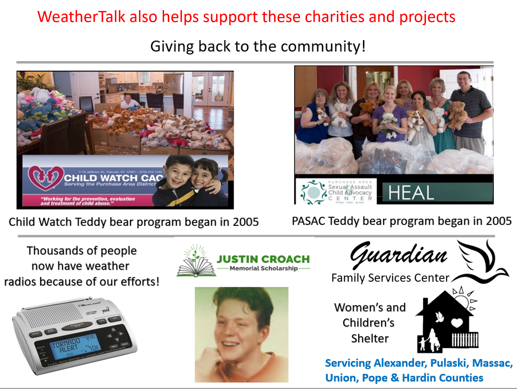
- Your subscription also will help support several local charities.
Haven’t you subscribed? Subscribe at www.beaudodsonweather.com

Your subscription also helps support these local charities and projects.
I encourage subscribers to use the app vs regular text messaging. We have found text messaging to be delayed during severe weather. The app typically will receive the messages instantly. I recommend people have three to four methods of receiving their severe weather information.
Remember, my app and text alerts are hand typed and not computer generated. You are being given personal attention during significant weather events.

WWW.WEATHERTALK.COM subscribers, here is my day to day schedule for your weather products.


We offer interactive local city live radars and regional radars. If a radar does not update then try another one. If a radar does not appear to be refreshing then hit Ctrl F5. You may also try restarting your browser.

Interactive Radars:
Interactive live weather radar page. Choose the city nearest your location. If one of the city radars won’t load then try a nearby one. Click here.
June 11, 2018
Monday Forecast Details
Forecast: Mostly sunny. Some cumulus clouds. An isolated thunderstorm possible. Most areas will remain dry. Greatest rain chances will be towards Mt Vernon and then towards Owensboro. Along that line and near that line. Storms will be more numerous in that area.
Temperatures: MO ~ 88 to 94 IL ~ 88 to 94 KY ~ 88 to 94 TN ~ 88 to 94
What is the chance of precipitation? MO ~ 20% IL ~ 30% (except northeast counties where it will be higher) KY ~ 30% (except northwest Kentucky where it will be higher) TN ~ 20%
Coverage of precipitation: Scattered. More numerous towards Mt Vernon, IL southeast towards Owensboro, KY.
Winds: South 5 to 10 mph
What impacts are anticipated from the weather? Scattered wet roadways, lightning, and gusty winds.
My confidence in the forecast verifying: High
Is severe weather expected? Typical summer isolated severe risk. Isolated downburst winds from dying storms.
The NWS defines severe weather as 58 mph wind or great, 1″ hail or larger, and/or tornadoes
Should I cancel my outdoor plans? No, but monitor radars
UV Index: 10 to 11 Very high
Sunrise: 5:34 AM
Flash flooding is a concern where slow moving storms occur. Especially true from the Mt Vernon, IL area southeast towards Ownseboro (where heavy rain fell over the weekend)
Monday Night Forecast Details:
Forecast: Partly cloudy. Scattered showers and thunderstorms.
Temperatures: MO ~ 70 to 74 IL ~ 70 to 74 KY ~ 70 to 74 TN ~ 70 to 74
What is the chance of precipitation? MO ~ 30% IL ~ 40% (except northeast counties where it will be higher) KY ~ 30% (except northwest Kentucky where it will be higher) TN ~ 20%
Coverage of precipitation: Scattered
Winds: Southwest 5 to 10 mph
What impacts are anticipated from the weather? Wet roadways. Lightning. Where summer storms occur you can have locally heavy downpours, small hail, and strong winds.
My confidence in the forecast verifying: High
Is severe weather expected? I can’t rule out a severe thunderstorm. There remain some questions on coverage of precipitation.
The NWS defines severe weather as 58 mph wind or great, 1″ hail or larger, and/or tornadoes
Should I cancel my outdoor plans? No, but monitor updates and radars
Sunset: 8:15 PM
Moonrise: 4:05 AM Waning Crescent
Moonset: 5:53 PM
June 12, 2018
Tuesday Forecast Details
Forecast: Partly sunny. Scattered thunderstorms. Some storms will be intense. Hot and muggy.
Temperatures: MO ~ 90 to 94 IL ~ 90 to 94 KY ~ 90 to 94 TN ~ 90 to 94
What is the chance of precipitation? MO ~ 40% IL ~ 50% KY ~ 50% TN ~ 40%
Coverage of precipitation: Scattered
Winds: South and southwest winds at 7 to 14 mph
What impacts are anticipated from the weather? Wet roadways. Lightning. High winds possible near storms. Nickel size hail. Torrential downpours of one to two inches per hour. Some flash flooding is possible is storms train over the same areas.
My confidence in the forecast verifying: Medium
Is severe weather expected? A few severe thunderstorms are possible. Monitor updates.
The NWS defines severe weather as 58 mph wind or great, 1″ hail or larger, and/or tornadoes
Should I cancel my outdoor plans? Monitor updates and radars.
UV Index: 9 to 10 Very high
Sunrise: 5:34 AM
Flash flooding is a concern where slow moving storms occur. Especially true from the Mt Vernon, IL area southeast towards Ownseboro (where heavy rain fell over the weekend)
Tuesday Night Forecast Details:
Forecast: Quite a few clouds. Scattered strong thunderstorms. Warm. Humid.
Temperatures: MO ~ 68 to 72 IL ~ 68 to 72 KY ~ 68 to 72 TN ~ 68 to 72
What is the chance of precipitation? MO ~ 30% IL ~ 40% KY ~ 40% TN ~ 40%
Coverage of precipitation: Scattered
Winds: West and southwest 7 to 14 mph
What impacts are anticipated from the weather? Wet roadways. Lightning. High winds possible near storms. Nickel size hail. Torrential downpours possible.
My confidence in the forecast verifying: Medium
Is severe weather expected? I can’t rule out severe thunderstorms. Monitor updates, especially early in the night.
The NWS defines severe weather as 58 mph wind or great, 1″ hail or larger, and/or tornadoes
Should I cancel my outdoor plans? Monitor updates and radars.
Sunset: 8:15 PM
Moonrise: 4:45 AM Waning Crescent
Moonset: 7:03 PM
June 13, 2018
Wednesday Forecast Details
Forecast: Partly sunny. A chance of scattered thunderstorms.
Temperatures: MO ~ 88 to 92 IL ~ 86 to 92 KY ~ 86 to 92 TN ~ 88 to 92
What is the chance of precipitation? MO ~ 30% IL ~ 30% KY ~ 40% TN ~ 40%
Coverage of precipitation: Scattered
Winds: West and northwest at 5 to 10 mph
What impacts are anticipated from the weather? Scattered wet roadways. Lightning. Where summer storms occur you can have locally heavy downpours, small hail, and strong winds.
My confidence in the forecast verifying: Medium
Is severe weather expected? Typical summer isolated severe risk. Isolated downburst winds from dying storms.
The NWS defines severe weather as 58 mph wind or great, 1″ hail or larger, and/or tornadoes
Should I cancel my outdoor plans? No, but monitor radars
UV Index: 9 to 10 Very high
Sunrise: 5:34 AM
Wednesday Night Forecast Details:
Forecast: Partly cloudy. Warm. Humid. Isolated thunderstorms again possible.
Temperatures: MO ~ 68 to 72 IL ~ 66 to 72 KY ~ 68 to 72 TN ~ 68 to 72
What is the chance of precipitation? MO ~ 20% IL ~ 20% KY ~ 20% TN ~ 20%
Coverage of precipitation: Isolated
Winds: Light and variable winds
What impacts are anticipated from the weather? Isolated wet roadways. Lightning. Where summer storms occur you can have locally heavy downpours, small hail, and strong winds.
My confidence in the forecast verifying: Medium
Is severe weather expected? No
The NWS defines severe weather as 58 mph wind or great, 1″ hail or larger, and/or tornadoes
Should I cancel my outdoor plans? No
Sunset: 8:16 PM
Moonrise: 5:33 AM New
Moonset: 8:12 PM
June 14, 2018
Thursday Forecast Details
Forecast: A mix of sun and clouds. Hot and humid. A slight chance of an isolated thunderstorm.
Temperatures: MO ~ 88 to 92 IL ~ 88 to 92 KY ~ 88 to 92 TN ~ 88 to 92
What is the chance of precipitation? MO ~ 10% IL ~ 20% KY ~ 20% TN ~ 10%
Coverage of precipitation: None to isolated
Winds: East and southeast at 5 to 10 mph
What impacts are anticipated from the weather? None to isolated wet roadways. Lightning. Where summer storms occur you can have locally heavy downpours, small hail, and strong winds.
My confidence in the forecast verifying: Medium
Is severe weather expected? Typical summer isolated severe risk. Isolated downburst winds from dying storms.
The NWS defines severe weather as 58 mph wind or great, 1″ hail or larger, and/or tornadoes
Should I cancel my outdoor plans? No, but monitor radars
UV Index: 9 to 10 Very high
Sunrise: 5:34 AM
Thursday Night Forecast Details:
Forecast: Mostly clear. A few clouds. Warm. Humid. An isolated storm possible. Most areas will remain dry.
Temperatures: MO ~ 68 to 74 IL ~ 68 to 74 KY ~ 68 to 74 TN ~ 68 to 74
What is the chance of precipitation? MO ~ 10% IL ~ 10% KY ~ 10% TN ~ 10%
Coverage of precipitation: None to isolated
Winds: South and southwest 5 to 10 mph
What impacts are anticipated from the weather? None to isolated wet roadways. Lightning. Where summer storms occur you can have locally heavy downpours, small hail, and strong winds.
My confidence in the forecast verifying: Medium
Is severe weather expected? Typical summer isolated severe risk. Isolated downburst winds from dying storms.
The NWS defines severe weather as 58 mph wind or great, 1″ hail or larger, and/or tornadoes
Should I cancel my outdoor plans? No, but monitor radars
Sunset: 8:16 PM
Moonrise: 6:30 AM New
Moonset: 9:18 PM
June 15, 2018
Friday Forecast Details
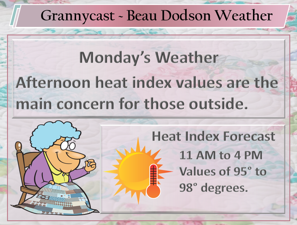
Forecast: Partly to mostly sunny. Hot and muggy. Heat index 95 to 100.
Temperatures: MO ~ 90 to 95 IL ~ 88 to 94 KY ~ 88 to 94 TN ~ 88 to 94
What is the chance of precipitation? MO ~ 10% IL ~ 10% KY ~ 10% TN ~ 10%
Coverage of precipitation: None to isolated. Slight chance.
Winds: South at 4 to 8 mph with gusts to 12 mph
What impacts are anticipated from the weather? None to isolated wet roadways. Lightning. Where summer storms occur you can have locally heavy downpours, small hail, and strong winds.
My confidence in the forecast verifying: Medium
Is severe weather expected? Typical summer isolated severe risk. Isolated downburst winds from dying storms.
The NWS defines severe weather as 58 mph wind or great, 1″ hail or larger, and/or tornadoes
Should I cancel my outdoor plans? No, but monitor radars
UV Index: 9 to 11 Very high
Sunrise: 5:34 AM
Friday Night Forecast Details:
Forecast: Mostly clear. A few clouds. Warm and humid.
Temperatures: MO ~ 70 to 74 IL ~ 70 to 74 KY ~ 70 to 74 TN ~ 70 to 74
What is the chance of precipitation? MO ~ 10% IL ~ 10% KY ~ 10% TN ~ 10%
Coverage of precipitation: None to isolated
Winds: South and southwest 5 to 10 mph
What impacts are anticipated from the weather? None to isolated wet roadways. Lightning. Where summer storms occur you can have locally heavy downpours, small hail, and strong winds.
My confidence in the forecast verifying: Medium
Is severe weather expected? Typical summer isolated severe risk. Isolated downburst winds from dying storms.
The NWS defines severe weather as 58 mph wind or great, 1″ hail or larger, and/or tornadoes
Should I cancel my outdoor plans? No, but monitor radars
Sunset: 8:17 PM
Moonrise: 7:32 AM Waxing Crescent
Moonset: 10:18 PM
June 16, 2018
Saturday Forecast Details
Forecast: Mostly sunny. Hot and muggy. Some cumulus clouds. Heat index 95 to 100.
Temperatures: MO ~ 92 to 96 IL ~ 90 to 95 KY ~ 90 to 95 TN ~ 92 to 96
What is the chance of precipitation? MO ~ 10% IL ~ 10% KY ~ 10% TN ~ 10%
Coverage of precipitation: None to isolated
Winds: Southwest at 4 to 8 mph
What impacts are anticipated from the weather? None to isolated wet roadways. Lightning. Where summer storms occur you can have locally heavy downpours, small hail, and strong winds.
My confidence in the forecast verifying: Medium
Is severe weather expected? Typical summer isolated severe risk. Isolated downburst winds from dying storms.
The NWS defines severe weather as 58 mph wind or great, 1″ hail or larger, and/or tornadoes
Should I cancel my outdoor plans? No, but monitor radars
UV Index: 9 to 11 Very high
Sunrise: 5:34 AM
Saturday Night Forecast Details:
Forecast: Mostly clear. A few clouds. Muggy. Warm.
Temperatures: MO ~ 70 to 74 IL ~ 70 to 74 KY ~ 70 to 74 TN ~ 70 to 74
What is the chance of precipitation? MO ~ 10% IL ~ 10% KY ~ 10% TN ~ 10%
Coverage of precipitation: None to isolated
Winds: South and southwest 5 to 10 mph
What impacts are anticipated from the weather? None to isolated wet roadways. Lightning. Where summer storms occur you can have locally heavy downpours, small hail, and strong winds.
My confidence in the forecast verifying: Medium
Is severe weather expected? Typical summer isolated severe risk. Isolated downburst winds from dying storms.
The NWS defines severe weather as 58 mph wind or great, 1″ hail or larger, and/or tornadoes
Should I cancel my outdoor plans? No, but monitor radars
Sunset: 8:17 PM
Moonrise: 8:42 AM Waxing Crescent
Moonset: 11:09 PM
June 17, 2018
Sunday Forecast Details
Forecast: Mostly sunny. Some cumulus clouds. Hot and muggy. Heat index 95 to 100.
Temperatures: MO ~ 92 to 96 IL ~ 90 to 95 KY ~ 90 to 95 TN ~ 92 to 96
What is the chance of precipitation? MO ~ 10% IL ~ 10% KY ~ 10% TN ~ 10%
Coverage of precipitation: None to isolated.
Winds: Southwest at 4 to 8 mph with gusts to 14 mph
What impacts are anticipated from the weather? None to isolated wet roadways. Lightning. Where summer storms occur you can have locally heavy downpours, small hail, and strong winds.
My confidence in the forecast verifying: Medium
Is severe weather expected? Typical summer isolated severe risk. Isolated downburst winds from dying storms.
The NWS defines severe weather as 58 mph wind or great, 1″ hail or larger, and/or tornadoes
Should I cancel my outdoor plans? No, but monitor radars
UV Index: 9 to 11 Very high
Sunrise: 5:34 AM
Sunday Night Forecast Details:
Forecast: Mostly clear. A few clouds. Muggy. Warm.
Temperatures: MO ~ 70 to 75 IL ~ 70 to 75 KY ~ 70 to 75 TN ~ 70 to 75
What is the chance of precipitation? MO ~ 10% IL ~ 10% KY ~ 10% TN ~ 10%
Coverage of precipitation: None to isolated
Winds: South and southwest 5 to 10 mph
What impacts are anticipated from the weather? Isolated wet roadways. Lightning. Where summer storms occur you can have locally heavy downpours, small hail, and strong winds.
My confidence in the forecast verifying: Medium
Is severe weather expected? Typical summer isolated severe risk. Isolated downburst winds from dying storms.
The NWS defines severe weather as 58 mph wind or great, 1″ hail or larger, and/or tornadoes
Should I cancel my outdoor plans? No, but monitor radars
Sunset: 8:17 PM
Moonrise: 9:49 AM Waxing Crescent
Moonset: 11:54PM
Learn more about the UV index readings. Click here.

Another week of hot and muggy conditions for the region.
We will have daily chances of isolated to widely scattered thunderstorms.
Highest rain chances today will be along and north/northeast/and east of this line.
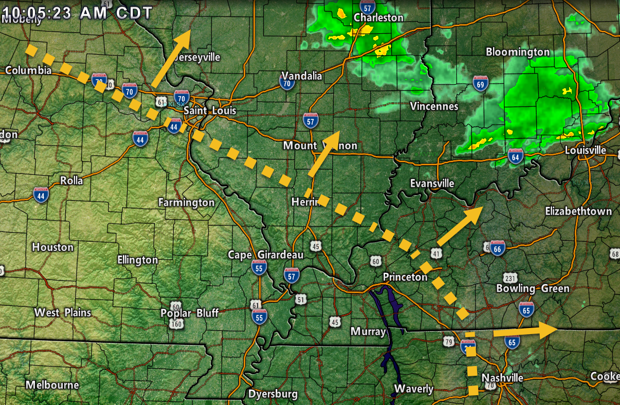
A cold front will push towards the region Monday night into Tuesday night. This boundary could mean increasing coverage of showers and thunderstorms. Some of the rain will be heavy.
Scattered thunderstorms, this time of the year, can always produce much heavier rain totals. Questions remain on the potential track of several thunderstorm complexes later this week.
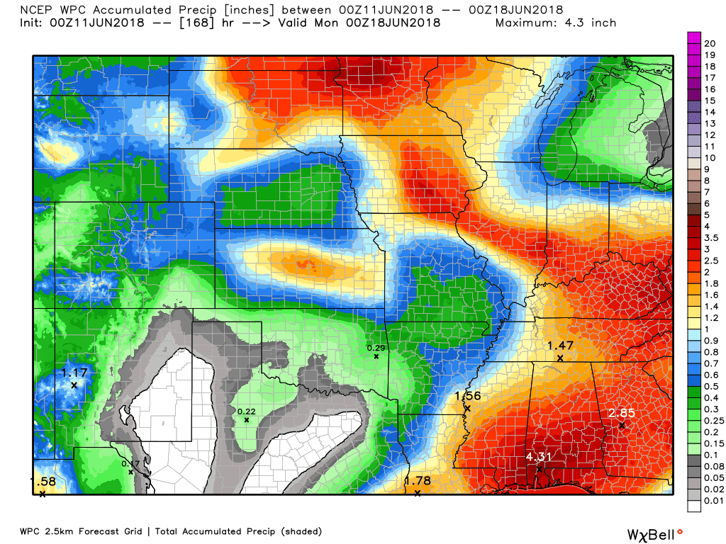
Here is the latest WPC / NOAA rainfall forecast.
This is broad brushed.
We are in a summer pattern. That means a WIDE range of rainfall totals (even within the same county).
This graphic will not cover those wild swings in rainfall totals that occur from locally heavy thunderstorms.
For some locations, these numbers are way too low.
This graphic takes us from now through next Monday.
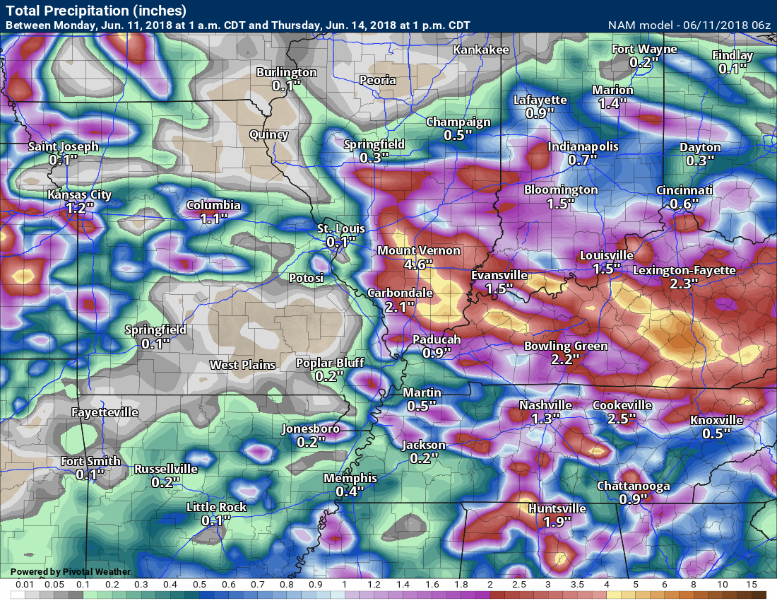
This next graphic is the NAM model guidance rainfall forecast through 1 AM Thursday.
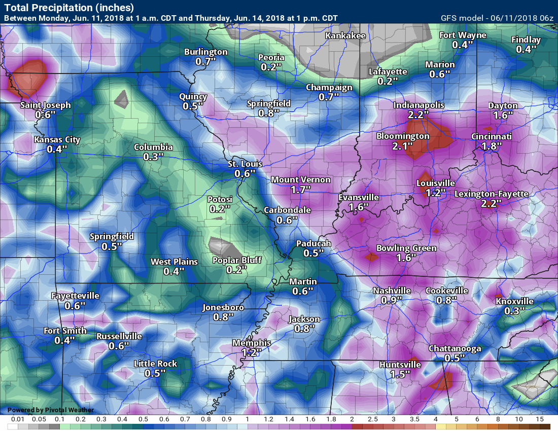
Notice the differences in each of the models. The differences center around thunderstorm complexes that commonly form during the summer months. These complexes are tricky, at best, to forecast more than 12 to 24 hours in advance. Rainfall totals can vary greatly within the complexes.
Click images to enlarge
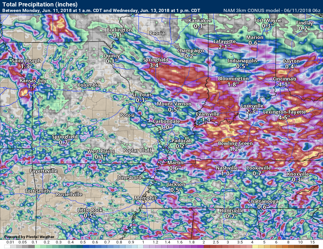
This next graphic is the 3K NAM
This goes through 1 AM Wednesday
HUGE differences between the model guidance.
This next graphic is the GFS model rainfall through Monday
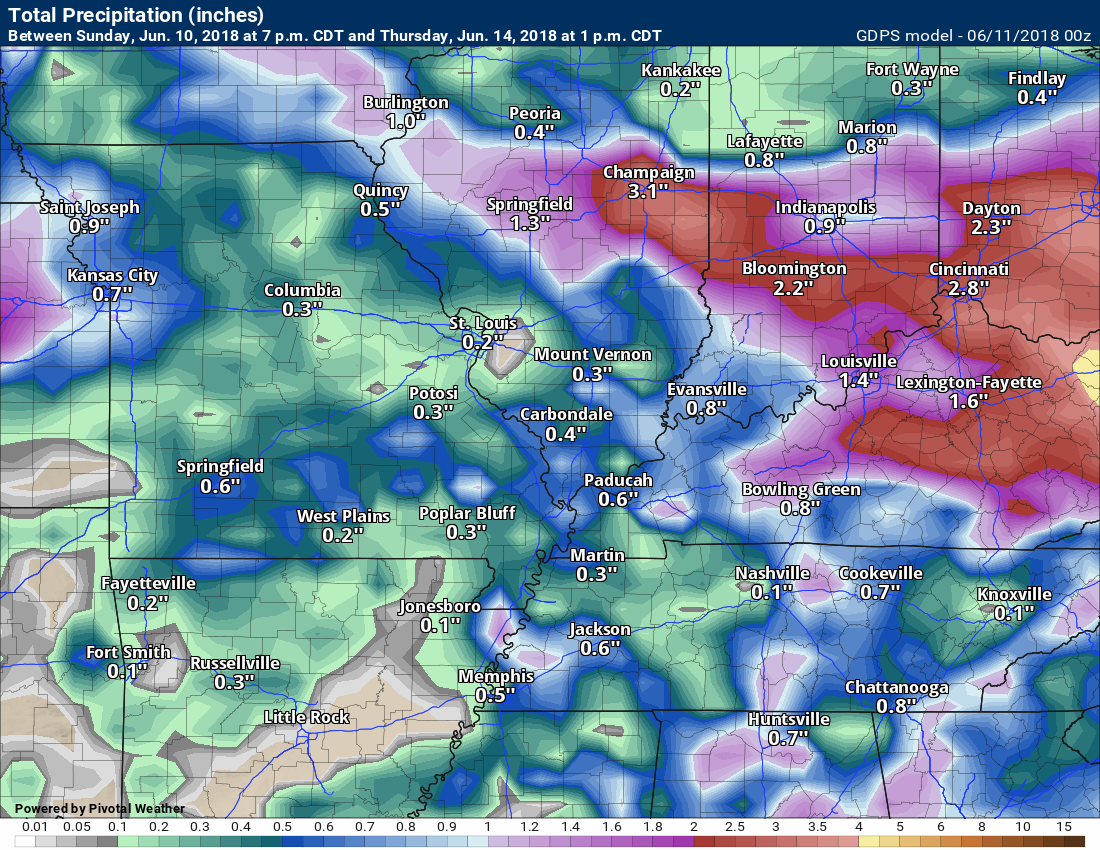
This next graphic is the GEM model rainfall total map through Monday
.

We offer interactive local city live radars and regional radars. If a radar does not update then try another one.
If a radar does not appear to be refreshing then hit Ctrl F5 on your keyboard.
You may also try restarting your browser.
The local city view radars also have clickable warnings.
During the winter months, you can track snow and ice by clicking the winterize button on the local city view interactive radars.

Questions? Broken links? Other questions?
You may email me at beaudodson@usawx.com

The National Weather Service defines a severe thunderstorm as one that produces quarter size hail or larger, 58 mph winds or greater, and/or a tornado.
Monday: Isolated summer-type thunderstorms will be possible. Where storms occur there will be heavy rain, gusty winds, small hail, and frequent cloud to ground lightning. At this time, organized severe weather appears unlikely. Isolated severe weather possible.
Monday night through Tuesday night: Thunderstorms are likely along an incoming cold front. Some of the storms could become severe with high winds, hail, frequent lightning, and torrential downpours. Monitor updates.
Wednesday through Sunday: Widely scattered summer-type thunderstorms will be possible. Where storms occur there will be heavy rain, gusty winds, small hail, and frequent cloud to ground lightning. At this time, organized severe weather appears unlikely. Monitor updates. Isolated severe weather risk.
![]()
Interactive live weather radar page. Choose the city nearest your location. If one of the cities does not work then try a nearby one. Click here.
National map of weather watches and warnings. Click here.
Storm Prediction Center. Click here.
Weather Prediction Center. Click here.

Live lightning data: Click here.

Interactive GOES R satellite. Track clouds. Click here.

Here are the latest local river stage forecast numbers Click Here.
Here are the latest lake stage forecast numbers for Kentucky Lake and Lake Barkley Click Here.

The spring and preliminary summer outlooks have been posted for subscribers. Scroll down to see the outlook.Not a subscriber? Learn more at this link.

Weather Headlines
- Muggy weather
- Cold front approaches the region tonight into Tuesday night
- The front could help focus thunderstorm activity (greater coverage)
- Daily chances for isolated to widely scattered thunderstorms into the weekend
Weather models have been useless over the last few days. They can not handle a summer pattern like the one we are in. The problem is placement of thunderstorms. There is lower than normal confidence in the overall forecast through Friday.
We did have thunderstorm activity over the weekend. Coverage on Saturday was much greater than Sunday. Most of the area remained dry Sunday.
Portions of Mississippi County, Missouri, and Ballard County, Kentucky, received very heavy rain totals in a short amount of time. There were also trees down in Wickliffe, Kentucky.
Check out this zoomed in radar estimated rain totals map. Some areas of the county barely had enough rain to wet the ground. Other areas were experiencing flooding.
This map underestimated some of the totals. There were reports of 4.5″ in Mississippi County, Missouri!
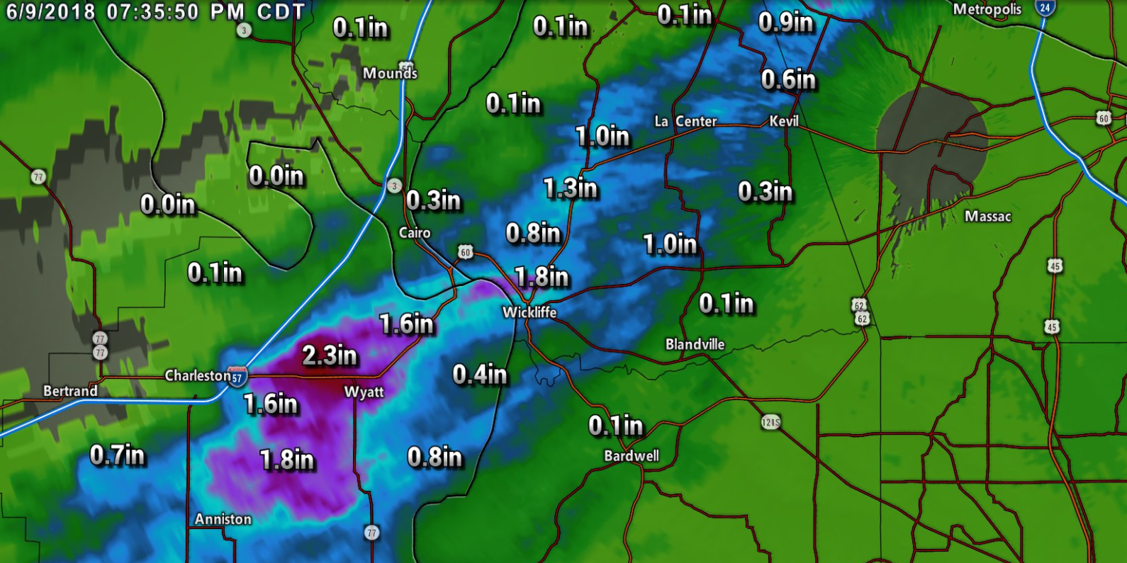
On Sunday, there was thunderstorm activity across northern parts of southeast Illinois into northwest Kentucky and then southward in the Pennyrile area. Heavy thunderstorms struck these areas. Hail and damaging winds were reported from some of the storms.
Daviess County, Kentucky, reported several trees down and barns damaged. This was mainly across the southeast portion of the county.
There were reports of nearly six inches of rain over portions of southeast Illinois since Friday.
Check out some of the rain totals from Sunday. Very heavy rain in portions of the region. Click to enlarge.

The big story this week will be the continued heat and muggy conditions. This is also known as summer!
Daily highs will range from 88 to 94 degrees. Heat index values during the afternoon hours will jump into the 95 to 100 degree range. Possibly higher in some locations.
This will make for uncomfortable outdoor activities between 11 am and 5 pm. Keep that in mind.
We will have daily thunderstorm chances. Typical summer storms. Where storms occur there could be gusty winds, hail, lightning, and torrential downpours.
A cold front will shift into the region late Monday night into Wednesday. This could cause an increase in thunderstorm coverage. Some of the storms could be severe. Monitor updates.
Heavy rain is a concern over the coming days. Some locations could easily exceed two inches of rain. Meanwhile, other areas may remain dry. Again, fairly typical pattern for this time of the year.
Avoid flooded roadways. Summer storms can occasionally cause flash flooding in localized areas.
Senior citizens will be dealing with heat and humidity over the coming days. Remember to check on them.
Do you know the symptoms of heat related illness?
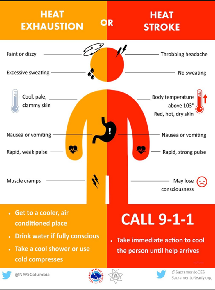
Also, don’t forget our outdoor friends.

![]()
The preliminary July forecast has been updated. The heat will likely be the big story.
Outlook definitions
EQ = Equal chances of above or below normal
BN= Below normal
M/BN = Much below normal
AN = Above normal
M/AN = Much above normal
E/AN = Extremely above normal.
This graphic is available for subscribers only. Subscribe at www.weathertalk.com
Outlook definitions
EQ = Equal chances of above or below normal
BN= Below normal
M/BN = Much below normal
AN = Above normal
M/AN = Much above normal
E/AN = Extremely above normal.
This graphic is available for subscribers only. Subscribe at www.weathertalk.com
![]()
These are bonus videos and maps for subscribers.
I bring these to you from the BAMwx team. I pay them to help with videos. They have a great team of meteorologists. The Ohio and Missouri Valley videos cover most of our area. They do not have a specific Tennessee Valley forecast but may add one in the future.
The long-range video is technical. Over time, you can learn a lot about meteorology from the long range video. Just keep in mind, it is a bit more technical.
NOTE: THESE ARE USUALLY NOT UPDATED ON SATURDAY OR SUNDAY.

This video is available for subscribers only. Subscribe at www.weathertalk.com

This video is available for subscribers only. Subscribe at www.weathertalk.com

This video is available for subscribers only. Subscribe at www.weathertalk.com

I bring these to you from the BAMwx team. They are excellent long-range forecasters.
Remember, long-range outlooks are a bit of skill, understanding weather patterns, and luck combined. It is not an exact science.

Outlook definitions
EQ = Equal chances of above or below normal
BN= Below normal
M/BN = Much below normal
AN = Above normal
M/AN = Much above normal
E/AN = Extremely above normal.
Normal high temperatures for this time of the year are around 88 degrees.
Normal low temperatures for this time of the year are around 65 degrees.
Normal precipitation during this time period ranges from 0.60″ to 0.80″
This outlook covers June 11th through June 17th
This graphic is available for subscribers only. Subscribe at www.weathertalk.com
The precipitation forecast is PERCENT OF NORMAL. For example, if your normal rainfall is 1.00″ and the graphic shows 10%, then that would mean 0.10″ of rain is anticipated.
This graphic is available for subscribers only. Subscribe at www.weathertalk.com

Outlook definitions
EQ = Equal chances of above or below normal
BN= Below normal
M/BN = Much below normal
AN = Above normal
M/AN = Much above normal
E/AN = Extremely above normal.
Normal high temperatures for this time of the year are around 90 degrees
Normal low temperatures for this time of the year are around 67 degrees
Normal precipitation during this time period ranges from 0.50″ to 0.80″
This outlook covers June 18th through June 24th
This graphic is available for subscribers only. Subscribe at www.weathertalk.com
The precipitation forecast is PERCENT OF NORMAL. For example, if your normal rainfall is 1.00″ and the graphic shows 10%, then that would mean 0.10″ of rain is anticipated.
This graphic is available for subscribers only. Subscribe at www.weathertalk.com

Outlook definitions
EQ = Equal chances of above or below normal
BN= Below normal
M/BN = Much below normal
AN = Above normal
M/AN = Much above normal
E/AN = Extremely above normal.
Normal high temperatures for this time of the year are around 91 degrees
Normal low temperatures for this time of the year are around 68 degrees
Normal precipitation during this time period ranges from 0.50″ to 0.80″
This outlook covers June 22nd through July 5th
This graphic is available for subscribers only. Subscribe at www.weathertalk.com
And precipitation
This graphic is available for subscribers only. Subscribe at www.weathertalk.com
June temperature and precipitation outlook
These graphics are available for subscribers only. Subscribe at www.weathertalk.com
These graphics are available for subscribers only. Subscribe at www.weathertalk.com
![]()

A new weather podcast is now available! Weather Geeks (which you might remember is on The Weather Channel each Sunday)
To learn more visit their website. Click here.
![]()

WeatherBrains Episode 646
We couldn’t get Google Hangouts to function for our guest this week, so this week’s WeatherBrains is a discussion amongst the regulars about what is on their minds.
Other discussions in this weekly podcast include topics like:
- Subtropical Storm Alberto
- Extreme heat in the Southwest early in season
- Negativity and fighting on social media
- Problematic attempts at forecasting random summertime afternoon storms
- “First Alert Days” and their place in 2018 broadcast meteorology
- and more!
Previous episodes can be viewed by clicking here.
We offer interactive local city live radars and regional radars. If a radar does not update then try another one. If a radar does not appear to be refreshing then hit Ctrl F5. You may also try restarting your browser.
The local city view radars also have clickable warnings.
During the winter months, you can track snow and ice by clicking the winterize button on the local city view interactive radars.
You may email me at beaudodson@usawx.com
Find me on Facebook!

Find me on Twitter!

Did you know that a portion of your monthly subscription helps support local charity projects?
You can learn more about those projects by visiting the Shadow Angel Foundation website and the Beau Dodson News website.

I encourage subscribers to use the app vs regular text messaging. We have found text messaging to be delayed during severe weather. The app typically will receive the messages instantly. I recommend people have three to four methods of receiving their severe weather information.
Remember, my app and text alerts are hand typed and not computer generated. You are being given personal attention during significant weather events.
