Keep in mind, everyone…the Saturday through Sunday rain chances will be associated with weak upper level disturbances moving through the area. It isn’t a strong cold front that sweeps in and out of here with one line of storms. As each impulse moves through the area it will spark “some” precipitation.
If big clusters of storms form over Kansas and Oklahoma/Texas today through Sunday then that will factor into our weather, as well. Dying thunderstorm complexes leave outflow boundaries. These boundaries move through our region. They can spark a few showers/storms, as well. Timing all of this is tricky, at best.
Not a clear cut YES or NO rain forecast through the weekend. Thus, it will make it very hard to tell you it will or won’t rain at your exact location. Again, because this is not one strong front pushing through the region. It is a series of weak disturbances that will interact with the instability and moisture over our region.
Wish it were straight forward, because I know many of you have outdoor events. I wouldn’t cancel any plans or change any plans. I would monitor updates. Monitor your radar phone app’s or online radar sources.
That is why I have been saying since last Friday and Saturday to have a back up plan in the back of your mind. Plan B!
We have some great sponsors for the Weather Talk Blog. Please let our sponsors know that you appreciate their support for the Weather Talk Blog.
Milner and Orr Funeral Home and Cremation Services located in Paducah, Kentucky and three other western Kentucky towns – at Milner and Orr they believe in families helping families. You can find Milner and Orr on Facebook, as well.
![]()

This forecast update covers far southern Illinois, far southeast Missouri, and far western Kentucky. See the coverage map on the right side of the blog.
Remember that weather evolves. Check back frequently for updates, especially during active weather.
The forecast numbers below may vary quite a bit across the region. These are the averages.
Saturday – Quite a few clouds around. Warm and muggy. A period of showers and thunderstorms possible during the morning and them more developing in the late afternoon. Some storms could be heavy. High temperatures in the 80’s with southerly winds at 10-15 mph.
My confidence in this part of the forecast verifying is high
Should I cancel my outdoor plans? Have a plan B ready to go.
WEATHER RADAR PAGE – Click here —
Saturday night – Quite a few clouds. A 40% chance of thunderstorms. Mild with lows in the 60’s. Southerly winds at 10 mph.
My confidence in this part of the forecast verifying is high
Should I cancel my outdoor plans? Have a plan B ready to go.
Sunday – Quite a few clouds around. Warm and muggy at times. A 30%-40% chance for showers and thunderstorms very early in the morning…then perhaps a lull for quite a bit of the day. Another chance for some storms late in the afternoon or evening hours. Lower than normal confidence on how Sunday unfolds. I would not cancel any plans…much of the day might end up dry. Some of the storms could be strong. High temperatures in the 80’s with southerly winds at 10-15 mph.
My confidence in this part of the forecast verifying is medium
Should I cancel my outdoor plans? Have a plan B ready to go. Could be some precipitation in the region.
Sunday night – Partly cloudy. A good chance for thunderstorms. Lows in the 60’s. South/southwest winds at 10-15 mph. Some storms could be on the heavy side.
My confidence in this part of the forecast verifying is medium
Should I cancel my outdoor plans? Have a plan B ready to go. Could be some precipitation in the region.
Monday – Partly to mostly cloudy. A good chance for showers and thunderstorms. A few storms could be on the heavy side. Highs in the upper 70’s to lower 80’s. Winds from the south at 10-15 mph.
My confidence in this part of the forecast verifying is high
Should I cancel my outdoor plans? Have a plan B ready to go. There will be some precipitation in the region.
![]()
![]()
Sunrise and Sunset Times – Click Here

Current Temperatures Around The Local Area


Don’t forget to check out the Southern Illinois Weather Observatory web-site for weather maps, tower cams, scanner feeds, radars, and much more! Click here

An explanation of what is happening in the atmosphere over the coming days…
Highlights
1. Chances for showers and storms over the weekend…don’t cancel your plans
2. Strongest storms likely to arrive on Monday along a cold front
3. We dry out by late Monday night and Tuesday
We had some heavy storms on Friday as a disturbance moved through the region. Even one or two reports of high winds. A few trees down here and there. The overall severe weather risk was very low. No organized severe weather occurred.
Those storms skirted off to the northeast and left behind a warm and humid air mass.
Additional disturbances will roll through the region on Saturday through Monday. Each disturbance could produce another round of showers and thunderstorms.
As I have been saying all week, don’t cancel any plans. Have a plan B in the back pocket. Monitor radars.
The severe weather risk is fairly low on Saturday into Sunday. I can’t rule out an isolated high wind event from the heaviest thunderstorms. But, organized severe weather is not forecast.
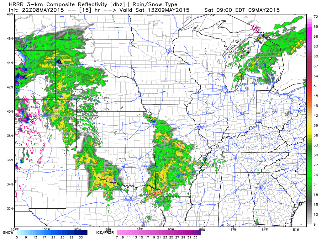
Here is the future-cast radar for 8 am on Saturday morning (some data brings this in sooner). See that area of precipitation to our southwest? That will be moving northeast. Image is from weatherbell.com

As far as timing…woosh that is a pain. One round of storms is possible on Saturday morning and then perhaps additional scattered storms in the afternoon. Saturday night a few scattered storms early and then perhaps a bit more after midnight.
Sunday will provide a warm and humid air mass for the region. Some storms could pop up during the morning and afternoon, but it might end up mostly dry. Very low confidence on Sunday’s forecast. The thinking is that morning storms will move out of the area (if they occur) and then a long lull in the precipitation. Additional storms will pop in the heat of the afternoon. Some question on timing. I would recommend monitoring updates. I have a feeling Sunday’s forecast will need some work.
Another disturbance moves through our region Sunday evening and night. This will spark another round of widespread showers and heavy thunderstorms. Isolated severe storms can’t be ruled out. Anytime you have CAPE values of 1000-3000…you can have a severe storm here and there.
Monday is when the cold front arrives. Whether we have severe storms on Monday will depend on timing of the cold front and cloud cover during the morning. If the sun comes out on Monday then the atmosphere will become more unstable. That would mean a greater chance for a few severe thunderstorms. It does not look like an outbreak is in the cards. Just a few reports of high winds and hail. We will see. Still a few days to monitor the Monday part of the forecast.
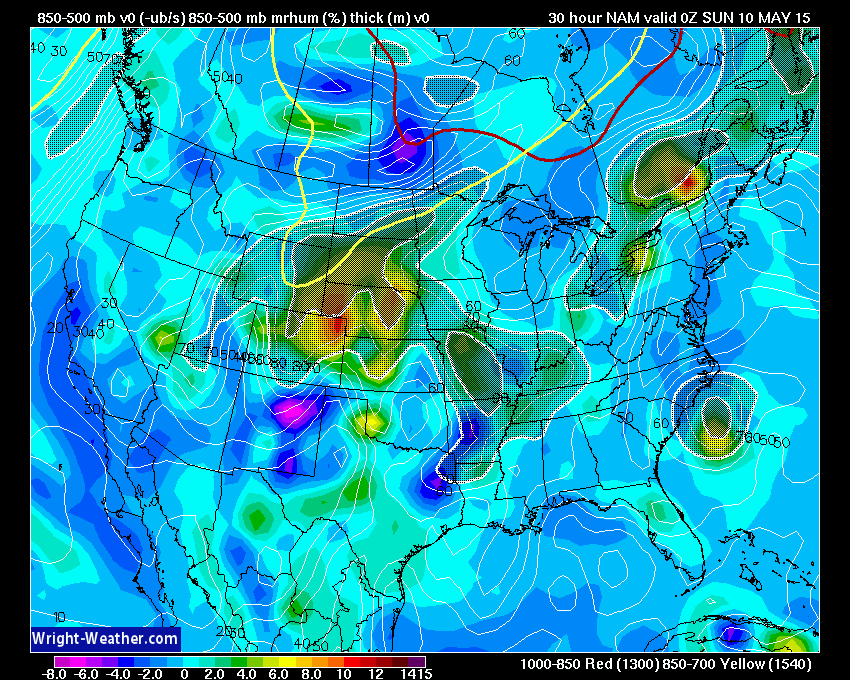
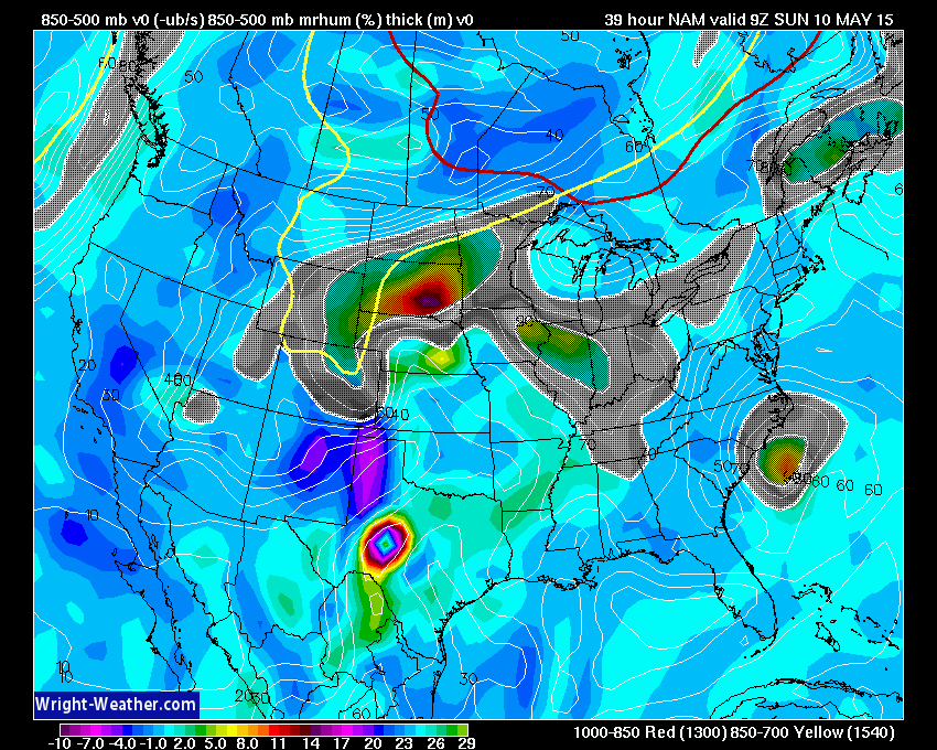
Let’s take a look at these disturbances that I keep talking about. These images are from wright-weather.com
Click images, as always, for larger views
These maps indicate lift. See the hatched dark area? Sometimes with colors embedded? Those are disturbances/lift. With the warm and humid air mass in place…each disturbance can spark showers and thunderstorms.
These disturbances are moving along in a southwest wind flow aloft. They move from southwest towards the northeast. Very hard to time these. Also difficult to gauge how many storms will form with each disturbance.
Here are the upper level maps (18,000 feet above the surface). See how the winds are coming out of the southwest? Those dark reds are very strong winds aloft. That will fuel Saturday’s severe weather in NE/KS/OK and TX.

This is the Saturday morning map. A disturbance is moving into our area from MO and AR. Again, the shaded area is the lift.

This image below is for Saturday evening. Additional lift moving through the area. That basically means that rain chances on Saturday could very well end up on/off throughout the day. Not the best answer to “will it rain on my parade”
Then on Saturday evening the lift pulls away. That hopefully will mean lesser rain/storm chances from Saturday evening into the overnight hours. There is some debate about a disturbance moving through late late late Saturday night (wee early morning hours of Sunday). See how the hatched area/shaded area is pulling away on the map below? That is the lift leaving our region.
This image is the lift on Sunday afternoon. Perhaps we will be in a lull much of Sunday. Then another disturbance pulls into our region Sunday evening. You can see it on the image below…coming in from Arkansas and Missouri.
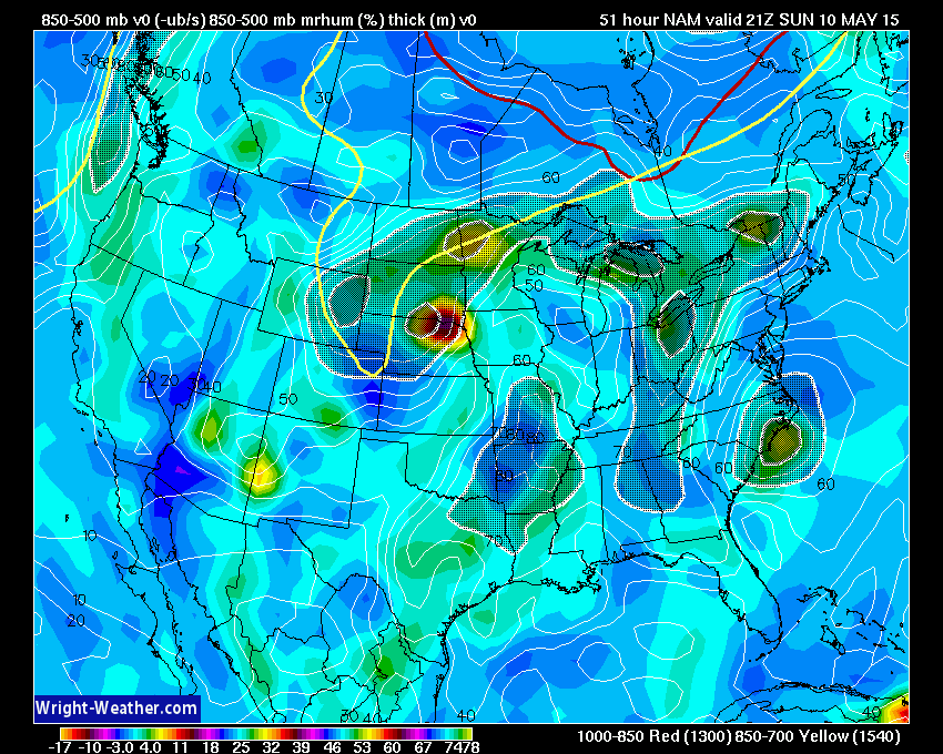
This image below is for Sunday evening. Definitely some lift in the area. This would come at a time of CAPE values of 1000-2000 (maybe a bit more). If so then some heavy storms would be possible.
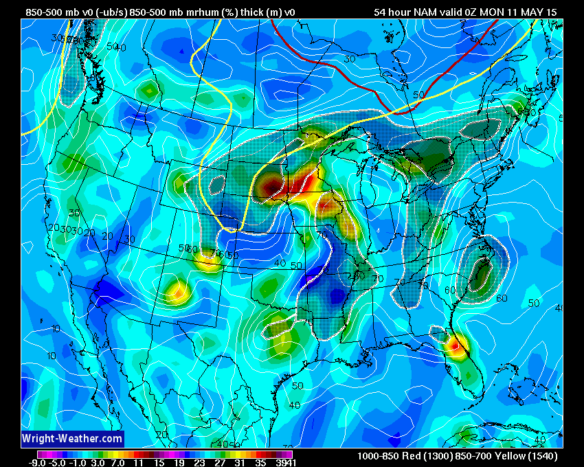
Then on Monday the main cold front arrives. We should have one round of storms late Sunday night into Monday morning. Then the question becomes…will the atmosphere recharge for some more storms Saturday afternoon. Stay tuned.
The bright colors here represent much stronger lift than the maps above. Again, this is because the cold front moves through the region. Better upper level support for showers and thunderstorms.

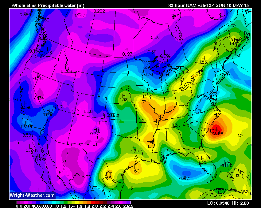
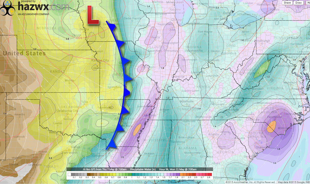
PWAT values will be quite high over the coming days. Lot of moisture in the atmosphere. Each time we see pooling of higher PWAT values it means the chances for locally heavy rain increase with any storms that form.
What are PWAT values? Great question! I found this blog post that explains it quite well. Click here for more information on PWAT values.
This map below is the Saturday afternoon PWAT values. See the orange? Those are high PWAT numbers pooling over our region.
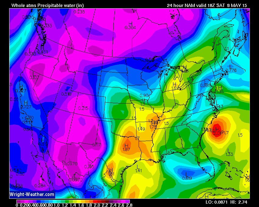
Those high PWAT values last into Saturday night. Now, whether we have anything to tap into those high PWAT values…that is the question. If storms form Saturday afternoon and night then they would produce very heavy downpours in a few spots.
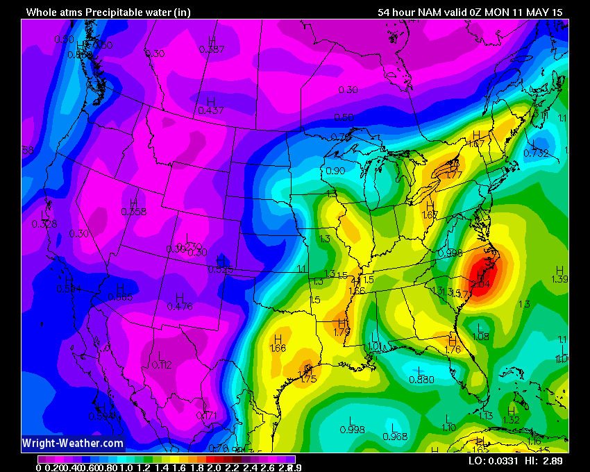
This map is for Sunday afternoon. See how the higher numbers/brighter colors have pulled away? This is that lull I mentioned. But look well to our south and southwest…those higher numbers will return with the next disturbance.

This is the Sunday evening map. The colors are brighter. Numbers have gone up again. If storms form on Sunday evening then they would produce torrential downpours in a few areas.
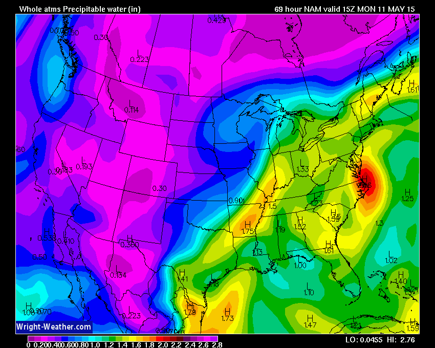
Then Monday we see the brighter colors right along the cold front. We call this pooling. Higher PWAT values pool ahead of the front and then dramatically drop off behind the front. Storms on Monday could produce heavy rain.
Monday’s Severe Weather Outlook
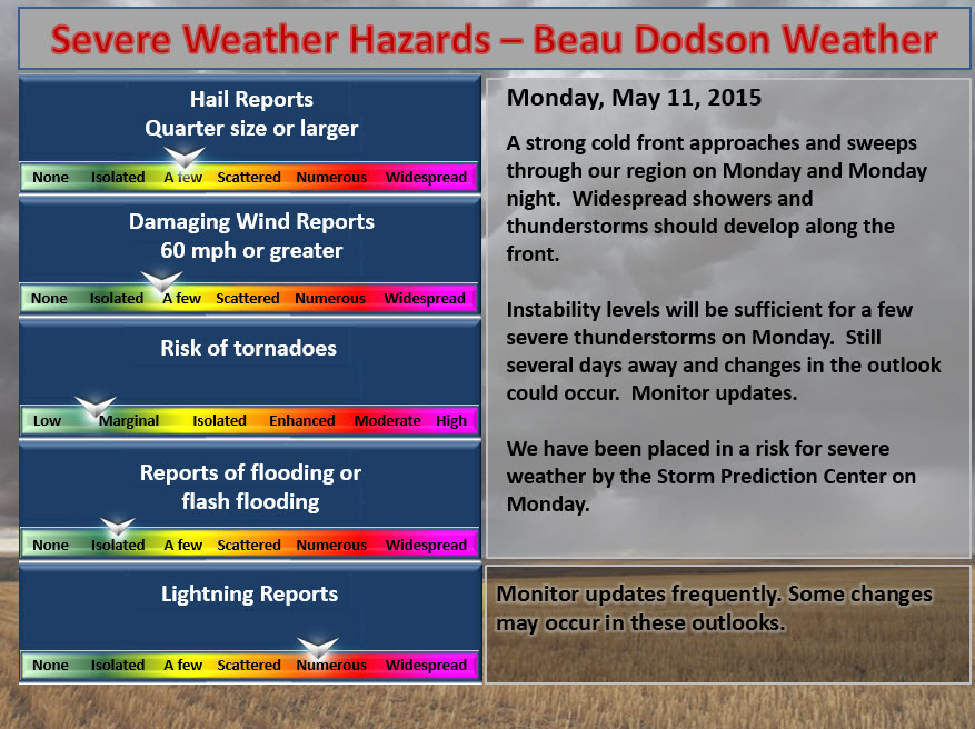
A cold front arrives on Monday. That front will provide the best chance for organized thunderstorms. The severe weather risk does not appear great, but I am monitoring it. A lot of factors have to come together to produce severe weather. Cloud cover, time of frontal passage, morning precipitation, wind fields aloft, and several other parameters need to be forecasted accurately to put together a severe weather forecast.
Here are the PWAT values on Monday. They are pooling ahead of the cold front.
PWAT values will be on the increase over the coming days. Quite a bit of moisture for storms to work with. Any storms that form could produce some decent downpours.
Radars
WEATHER RADAR PAGE – Click here —

I also set up a storm tracking page with additional links (use during active weather for quick reference)
Storm Tracking Tool Page
Don’t forget to support our sponsors!

I am concerned about lightning over the coming days. Those with outdoor plans should monitor updates.
Storms that form over the weekend could produce heavy downpours.
The strongest storms could produce gusty winds, as well. Small risk of hail.
Monday could bring a few severe storms. Perhaps Monday is the best chance for severe weather in our region. Still a few days to monitor that part of the forecast. Still too far out for certainties.

Yes. If you have outdoor plans then monitor radars and updates. Thunderstorms will be possible between now and Monday.
The greatest risk for organized severe storms will be on Monday. However, I can’t completely rule out a severe thunderstorm on Saturday and Sunday. The overall risk is small.
Lightning is going to be a concern for outdoor events throughout the weekend.
Again, I would not cancel any plans. I would, however, have a plan B in the back of your pocket.
Check out our sponsors! There are more on the right side bar of the page, as well. Be sure and let them know that you appreciate their sponsorship of the WeatherTalk daily weather bulletin.

Premier Portable Buildings proudly serving our region. For more information click the above ad or here
They can also be found on this Facebook page
G&C Multi-Services out of Paducah, Kentucky. G & C Multi-Services is a service provider in Western Kentucky that provides industrial and commercial equipment fabrication, machine troubleshooting, repair and maintenance, and installation. They can custom fabricate steel, stainless, and aluminum products per customer specifications.
Visit their web-site here. Or click the ad below! Facebook page.


Wortham Dental Care located in Paducah, Kentucky. The gentle dentist. Mercury free dentistry. They also do safe Mercury removal. You can find Wortham Dental Care on Facebook, as well

Trover’s Equipment and Lawn Care – Family owned and operated! They are a dealer for Snapper, Simplicity, Snapper Pro, Bad Boy Mowers, and Intimidator Utility Vehicles. They are a Stihl and Dolmar power products dealer. They also are a dealer for Briggs & Stratton, Kohler gas & diesel engines, and Kawasaki engines. They service and repair just about any brand. You can find them on Facebook, as well

Visit their web-site here. Or, you can also visit their Facebook page.

Endrizzi’s Storm Shelters – For more information click here. Endrizzi Contracting and Landscaping can be found on Facebook, as well – click here

Gary Eckelkamp’s web-site click the above banner or click here
.

Can we expect severe thunderstorms over the next 24 to 48 hours? Remember that a severe thunderstorm is defined as a thunderstorm that produces 58 mph winds or higher, quarter size hail or larger, and/or a tornado.
Thunderstorm threat level will be TWO on Saturday and Sunday. I may need to upgrade to THREE on Monday. Monitor updates.
.
Saturday Severe Weather Outlook – Some thunderstorms possible. Can’t completely rule out an isolated severe thunderstorm. Monitor updates.
Sunday Severe Weather Outlook – Thunderstorms are possible. Monitor updates…a few strong or severe storms not out of the question.
Monday Severe Weather Outlook – Severe thunderstorms are possible on Monday. Monitor updates.
Tuesday Severe Weather Outlook – Severe Weather Is Not Anticipated


How much precipitation should we expect over the next few days?
Typical for this time of the year, rainfall totals will vary greatly from one county to the next. If you end up under a slow moving thunderstorm then you can expect 1/2″-1″ in a short amount of time. This is the type of pattern where some counties could easily pick up more than 1″ of rain while other nearby counties end up with very little.
Overall, between now and Monday night…the region should pick up 0.40″-1.00″ of rain. Again, some spots will pick up a lot more than that. There is a lot of moisture available for thunderstorms that form.
This is the general rainfall forecast for the coming days.


This section of the blog is speculative forecast information. Because it is past the range of what meteorologists can forecast accurately, it should be considered speculation. Anything past day 5 is considered a long range forecast.
We will dry out late Monday night and Tuesday. Some of the data wants to bring moisture back into the region as early as Wednesday. Perhaps Thursday is a better bet for a few storms. This will need to be monitored.
Appears a 20%-40% chance for precipitation will be with us from Thursday into Friday/Saturday. Still a number of days to monitor. Temperatures will be in the 70’s to perhaps lower 80’s during most of next week.
Some indications that rain chances may increase on Friday into the following Monday. But, that is so far out…no confidence. Keep it in mind.

We have regional radars and local city radars – if a radar does not seem to be updating then try another one. Occasional browsers need their cache cleared. You may also try restarting your browser. That usually fixes the problem. Occasionally we do have a radar go down. That is why I have duplicates. Thus, if one fails then try another one.
If you have any problems then please send me an email beaudodson@usawx.com
WEATHER RADAR PAGE – Click here —
We also have a new national interactive radar – you can view that radar by clicking here.
Local interactive city radars include St Louis, Mt Vernon, Evansville, Poplar Bluff, Cape Girardeau, Marion, Paducah, Hopkinsville, Memphis, Nashville, Dyersburg, and all of eastern Kentucky – these are interactive radars. Local city radars – click here
NOTE: Occasionally you will see ground clutter on the radar (these are false echoes). Normally they show up close to the radar sites – including Paducah.

Regional Radar – Click on radar to take you our full radar page.


Regional Radar

Live Lightning Data – zoom and pan: Click here
Live Lightning Data with sound (click the sound button on the left side of the page): Click here
I also set up a storm tracking page with additional links (use during active weather for quick reference)
Storm Tracking Tool Page

For the most up to date maps – click here


![]()
Current WARNINGS (a warning means take action now). Click on your county to drill down to the latest warning information. Keep in mind that there can be a 2-3 minute delay in the updated warning information.
I strongly encourage you to use a NOAA Weather Radio or warning cell phone app for the most up to date warning information. Nothing is faster than a NOAA weather radio.


Color shaded counties are under some type of watch, warning, advisory, or special weather statement. Click your county to view the latest information.

Missouri Warnings

Illinois Warnings

Kentucky Warnings

Please visit your local National Weather Service Office by clicking here. The National Weather Service Office, for our region, is located in Paducah, Kentucky. They have a lot of maps and information on their site. Local people…local forecasters who care about our region.

Here is the official 6-10 day and 8-14 day temperature and precipitation outlook. Check the date stamp at the top of each image (so you understand the time frame).
The forecast maps below are issued by the Weather Prediction Center (NOAA).


The latest 8-14 day temperature and precipitation outlook. Note the dates are at the top of the image. These maps DO NOT tell you how high or low temperatures or precipitation will be. They simply give you the probability as to whether temperatures or precipitation will be above or below normal.


Who do you trust for your weather information and who holds them accountable?
I have studied weather in our region since the late 1970’s. I have 37 years of experience in observing our regions weather patterns. My degree is in Broadcast Meteorology from Mississippi State University and an Associate of Science (AS). I am currently working on my Bachelor’s Degree in Geoscience. Just need to finish two Spanish classes!
I am a member of the American Meteorological Society. I am a NOAA Weather-Ready Nation Ambassador. And, I am the Meteorologist for McCracken County Emergency Management.
I own and operate the Southern Illinois Weather Observatory.
There is a lot of noise on the internet. A lot of weather maps are posted without explanation. Over time you should learn who to trust for your weather information.
My forecast philosophy is simple and straight forward.
- Communicate in simple terms
- To be as accurate as possible within a reasonable time frame before an event
- Interact with you on Twitter, Facebook, and the blog
- Minimize the “hype” that you might see on television or through other weather sources
- Push you towards utilizing wall-to-wall LOCAL TV coverage during severe weather events
I am a recipient of the Mark Trail Award, WPSD Six Who Make A Difference Award, Kentucky Colonel, and the Caesar J. Fiamma” Award from the American Red Cross. In 2009 I was presented with the Kentucky Office of Highway Safety Award. I was recognized by the Kentucky House of Representatives for my service to the State of Kentucky leading up to several winter storms and severe weather outbreaks.
If you click on the image below you can read the Kentucky House of Representatives Resolution.

I am also President of the Shadow Angel Foundation which serves portions of western Kentucky and southern Illinois.
Many of my graphics are from www.weatherbell.com – a great resource for weather data, model data, and more


This blog was inspired by ABC 33/40’s Alabama Weather Blog – view their blog
Current tower cam view from the Weather Observatory- Click here for all cameras.

Southern Illinois Weather Observatory

The Weather Observatory

Southern Illinois Weather Observatory
WSIL TV 3 has a number of tower cameras. Click here for their tower camera page & Illinois Road Conditions

Marion, Illinois
WPSD TV 6 has a number of tower cameras. Click here for their tower camera page & Kentucky Road Conditions & Kentucky Highway and Interstate Cameras

Downtown Paducah, Kentucky
Benton, Kentucky Tower Camera – Click here for full view

Benton, Kentucky

I24 Paducah, Kentucky

I24 Mile Point 9 – Paducah, KY

I24 – Mile Point 3 Paducah, Kentucky

You can sign up for my AWARE email by clicking here I typically send out AWARE emails before severe weather, winter storms, or other active weather situations. I do not email watches or warnings. The emails are a basic “heads up” concerning incoming weather conditions.