Great morning, everyone! I hope you had a wonderful weekend.
.
We have an unsettled week of weather ahead. Yes, that does mean more rain!
.
I am beginning to post daily videos on the Weather Talk website. Those are for subscribers and can be viewed behind the video tab. I am also going to have some guest meteorologists helping with videos, as well.
.
Here is the latest video update
https://weathertalk.com/app/beaucast
.
Forecast:


This forecast update covers far southern Illinois, far southeast Missouri, and far western Kentucky. See the coverage map on the right side of the blog
May 7, 2017
Sunday Night Forecast Details:
Forecast: Mostly clear. Perhaps a few passing clouds.
Temperatures: MO ~ 46 to 52 IL ~ 46 to 52 KY ~ 48 to 54 TN ~ 48 to 54
Winds: Variable winds at 4 to 8 mph
My confidence in the forecast verifying: High. This forecast should verify.
What impacts are anticipated from the weather? None
Is severe weather expected? No
The NWS defines severe weather as 58 mph winds or great, 1″ hail or larger, and/or tornadoes
What is the chance of precipitation? MO ~ 10% IL ~ 10% KY ~ 0% TN ~ 0%
Coverage of precipitation: None to isolated
Should I cancel my outdoor plans? No
.
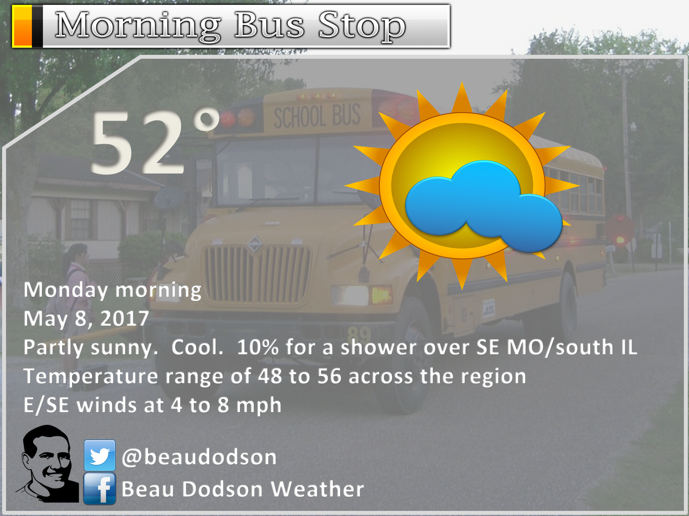
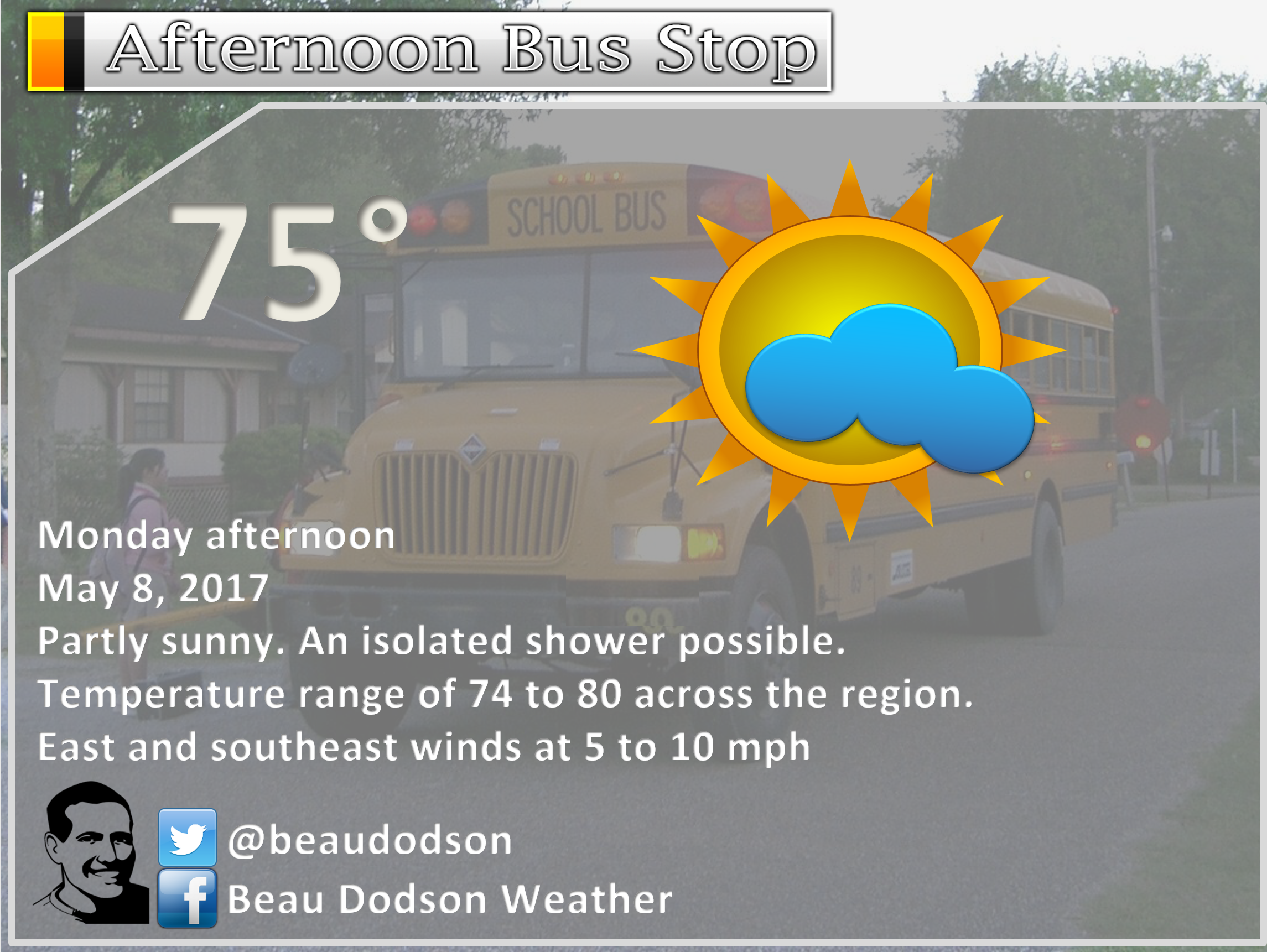
May 8, 2017
Monday Forecast Details
Forecast: A mix of sun and clouds. A chance for a shower over northern parts of southeast Missouri, southern Illinois, and northwest Kentucky. Some guidance shows several bands of clouds in the region. This might impact temperatures. Highest risk for clouds would be over Illinois and Kentucky.
Temperatures: MO ~ 74 to 78 IL 70 to 75 KY 72 to 76 TN 72 to 76
Winds: South and southwest winds at 6 to 12 mph with gusts to 18 mph.
What impacts are anticipated from the weather? Wet roadways if showers develop (IL/KY)
My confidence in the forecast verifying: Medium. Some adjustments are possible.
Is severe weather expected? No
The NWS defines severe weather as 58 mph winds or great, 1″ hail or larger, and/or tornadoes
What is the chance of precipitation? MO ~ 20% IL ~ 30% KY ~ 30% TN ~ 10%
Coverage of precipitation: Isolated
Should I cancel my outdoor plans? No
Monday Night Forecast Details:
Forecast: Partly cloudy. Not as cool as recent nights. A chance for a showers over southern Illinois and northwest Kentucky. Breezy.
Temperatures: MO ~ 56 to 64 IL ~ 56 to 64 KY ~ 58 to 64 TN ~ 58 to 64
Winds: Southerly winds at 6 to 12 mph with gusts to 22 mph
My confidence in the forecast verifying: High. This forecast should verify.
What impacts are anticipated from the weather? Isolated wet roadways
Is severe weather expected? No
The NWS defines severe weather as 58 mph winds or great, 1″ hail or larger, and/or tornadoes
What is the chance of precipitation? MO ~ 0% IL ~ 0% KY ~ 10% TN ~ 0%
Coverage of precipitation: Isolated
Should I cancel my outdoor plans? No
.
May 9, 2017
Tuesday Forecast Details
Forecast: Partly sunny. Warmer. Breezy.
Temperatures: MO ~ 76 to 84 IL 76 to 84 KY 80 to 84 TN 80 to 85
Winds: West and southwest winds at 8 to 16 mph with gusts to 25 mph
What impacts are anticipated from the weather? Most likely none. Small chance for wet roads and lightning.
My confidence in the forecast verifying: High. This forecast should verify.
Is severe weather expected? No
The NWS defines severe weather as 58 mph winds or great, 1″ hail or larger, and/or tornadoes
What is the chance of precipitation? MO ~ 10% IL ~ 10% KY ~ 5% TN ~ 5%
Coverage of precipitation: None to isolated
Should I cancel my outdoor plans? No
Tuesday Night Forecast Details:
Forecast: Partly cloudy. A 20% for a shower or thunderstorm. The rain chances would mainly be over northern parts of southeast Missouri, northern parts of southern Illinois, and northwest Kentucky.
Temperatures: MO ~ 60 to 65 IL ~ 60 to 65 KY ~ 60 to 65 TN ~ 62 to 66
Winds: West and southwest winds at 5 to 10 mph with gusts to 18 mph.
My confidence in the forecast verifying: High. This forecast should verify.
What impacts are anticipated from the weather? Maybe some wet roads and lightning (mainly northern counties of the region)
Is severe weather expected? No
The NWS defines severe weather as 58 mph winds or great, 1″ hail or larger, and/or tornadoes
What is the chance of precipitation? MO ~ 20% IL ~ 20% KY ~ 20% TN ~ 10%
Coverage of precipitation: Isolated
Should I cancel my outdoor plans? No
.
May 10, 2017
Wednesday Forecast Details
Forecast: A mix of sun and clouds. A 20% for a shower or thunderstorm.
Temperatures: MO ~ 78 to 84 IL 76 to 82 KY 78 to 84 TN 78 to 84
Winds: West and southwest at 8 to 16 mph with gusts to 22 mph
What impacts are anticipated from the weather? Wet roadways. Lightning.
My confidence in the forecast verifying: Medium. Some adjustments are possible.
Is severe weather expected? No
The NWS defines severe weather as 58 mph winds or great, 1″ hail or larger, and/or tornadoes
What is the chance of precipitation? MO ~ 20% IL ~ 20% KY ~ 20% TN ~ 20%
Coverage of precipitation: Isolated to scattered
Should I cancel my outdoor plans? No, but monitor updated forecasts.
Wednesday Night Forecast Details:
Forecast: Mostly cloudy. Scattered showers and perhaps some thunderstorms late at night.
Temperatures: MO ~ 62 to 66 IL ~ 62 to 66 KY ~ 62 to 66 TN ~ 62 to 66
Winds: West and southwest winds at 7 to 14 mph with gusts to 18 mph
My confidence in the forecast verifying: Medium. Some adjustments are possible.
What impacts are anticipated from the weather? Wet roadways. Lightning.
Is severe weather expected? Not at this time
The NWS defines severe weather as 58 mph winds or great, 1″ hail or larger, and/or tornadoes
What is the chance of precipitation? MO ~ 50% IL ~ 50% KY ~ 40% TN ~ 40%
Coverage of precipitation: Scattered
Should I cancel my outdoor plans? No
.
May 11, 2017
Thursday Forecast Details
Forecast: Cloudy. A good chance for showers and thunderstorms.
Temperatures: MO ~ 68 to 74 IL 68 to 74 KY 70 to 75 TN 72 to 76
Winds: Variable at 5 to 10 mph with gusts to 15 mph
What impacts are anticipated from the weather? Wet roadways. Lightning.
My confidence in the forecast verifying: Medium. Some adjustments are possible.
Is severe weather expected? Not at this time
The NWS defines severe weather as 58 mph winds or great, 1″ hail or larger, and/or tornadoes
What is the chance of precipitation? MO ~ 70% IL ~ 70% KY ~ 60% TN ~ 60%
Coverage of precipitation: Scattered to perhaps widespread
Should I cancel my outdoor plans? Have a plan B.
Thursday Night Forecast Details:
Forecast: Cloudy. A chance for showers and thunderstorms.
Temperatures: MO ~ 48 to 58 IL ~ 48 to 56 KY ~ 50 to 55 TN ~ 50 to 55
Winds: Winds becoming north and northeast as the front slides southward. Wind speed 5 to 10 mph with gusts to 12 mph
My confidence in the forecast verifying: Medium. Some adjustments are possible.
What impacts are anticipated from the weather? Wet roadways. Lightning.
Is severe weather expected? Not at this time
The NWS defines severe weather as 58 mph winds or great, 1″ hail or larger, and/or tornadoes
What is the chance of precipitation? MO ~ 60% IL ~ 60% KY ~ 60% TN ~ 60%
Coverage of precipitation: Scattered to perhaps widespread.
Should I cancel my outdoor plans? Monitor updates.
.
May 12, 2017
Friday Forecast Details
Forecast: Partly cloudy. Showers possible. Cooler.
Temperatures: MO ~ 60 to 65 IL 60 to 65 KY 60 to 65 TN 60 to 65
Winds: North winds at 10 to 20 mph. Gusty winds.
What impacts are anticipated from the weather? Wet roadways.
My confidence in the forecast verifying: Low. Significant adjustments are possible.
Is severe weather expected? No
The NWS defines severe weather as 58 mph winds or great, 1″ hail or larger, and/or tornadoes
What is the chance of precipitation? MO ~ 40% IL ~ 40% KY ~ 40% TN ~ 50%
Coverage of precipitation: Scattered
Should I cancel my outdoor plans? Monitor updated forecasts
Friday Night Forecast Details:
Forecast: Partly cloudy. Cooler.
Temperatures: MO ~ 45 to 50 IL ~ 45 to 50 KY ~ 45 to 50 TN ~ 45 to 50
Winds: North at 5 to 10 mph with gusts to 15 mph
My confidence in the forecast verifying: Low. Significant adjustments are possible.
What impacts are anticipated from the weather? Wet roadways.
Is severe weather expected? No
The NWS defines severe weather as 58 mph winds or great, 1″ hail or larger, and/or tornadoes
What is the chance of precipitation? MO ~ 10% IL ~ 10% KY ~ 10% TN ~ 10%
Coverage of precipitation: None anticipated. Small chance in northwest Tennessee. Should be over by Friday night.
Should I cancel my outdoor plans? No
.
Saturday should be dry with highs in the 70’s.
Sunday will deliver a mix of sun and clouds. A 20% for showers. Highs from 70 to 75. Low confidence on Sunday’s forecast.
.
and
.

Don’t forget to check out the Southern Illinois Weather Observatory web-site for weather maps, tower cams, scanner feeds, radars, and much more! Click here

An explanation of what is happening in the atmosphere over the coming day

Severe thunderstorm outlook.
Remember that a severe thunderstorm is defined as a thunderstorm that produces 60 mph winds or higher, quarter size hail or larger, and/or a tornado.
Sunday night through Monday night: Severe weather is not anticipated. Small chance for lightning on Monday and Monday night.
Tuesday through Thursday night: We will have on and off chances for showers and thunderstorms. I can’t rule out a few strong storms on Tuesday over our northern counties (Farmington towards Mt Vernon) and again on Wednesday and Thursday area-wide. The overall severe risk appears low, but perhaps not zero.
Friday through Sunday: Severe weather is not anticipated.
—————————————————————————-
Weather analysis for the next few days:
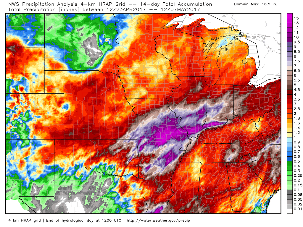
River flooding continues in many areas. Please avoid flooded roadways. Monitor crest levels.
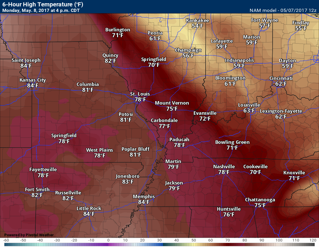
We do have some great temperatures in the forecast over the coming days. Let’s look at Monday, Tuesday, and Wednesday. Spring!!!
High temperatures each day will be dependent on cloud cover and rain chances. Where clouds are thicker you will be shaving quite a few degrees off the thermometer. Keep that in mind as we move through this new work week.
.
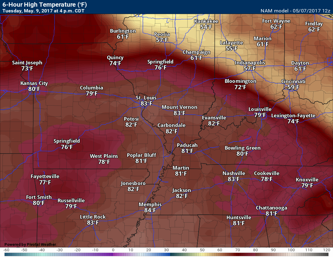
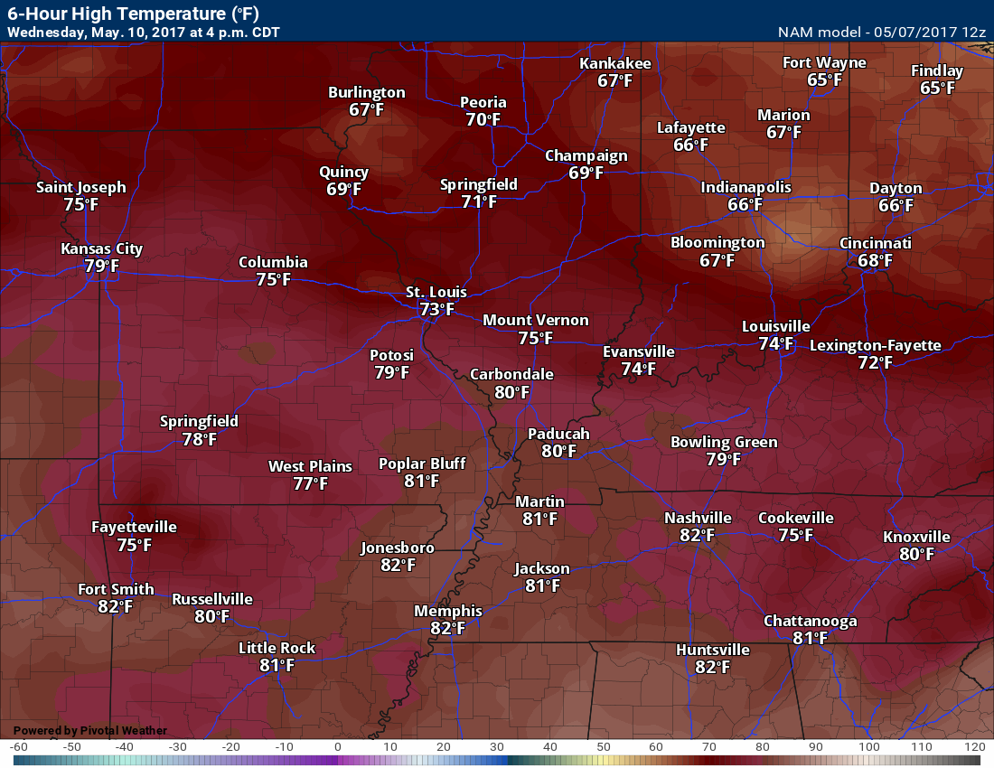
Notice the temperature differences over Illinois on Monday afternoon. That is because of clouds and some showers.
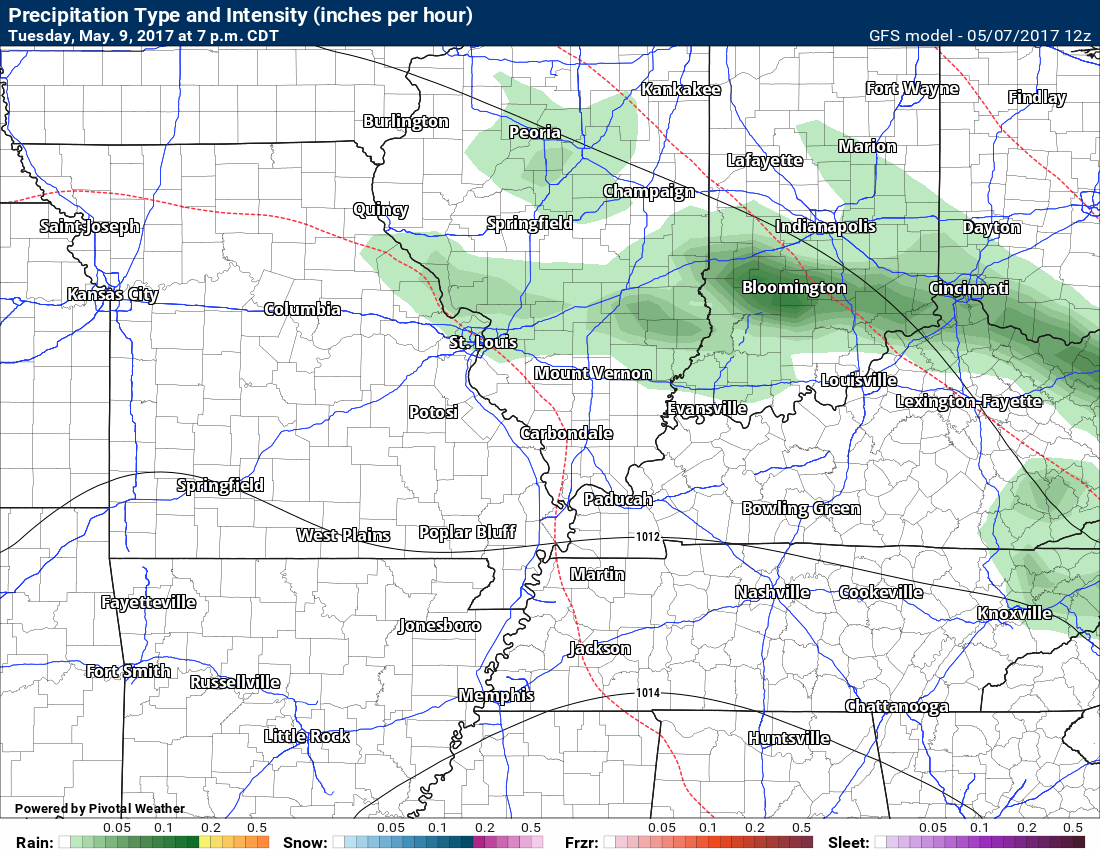
Tuesday (below)
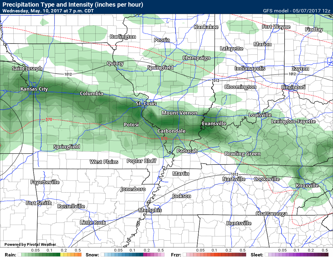
Wednesday
We have an unsettled week of weather ahead of us. There will be on and off rain chances. Rain chances will likely peak on Wednesday night into Thursday night. Lesser chances Monday, Tuesday, and Friday.
Rainfall totals this week should not be as large as recent weeks. I am anticipating widespread 0.40″ to 0.80″. Locally higher totals are certainly possible. If we end up with a few bands of thunderstorms then you can easily double those numbers.
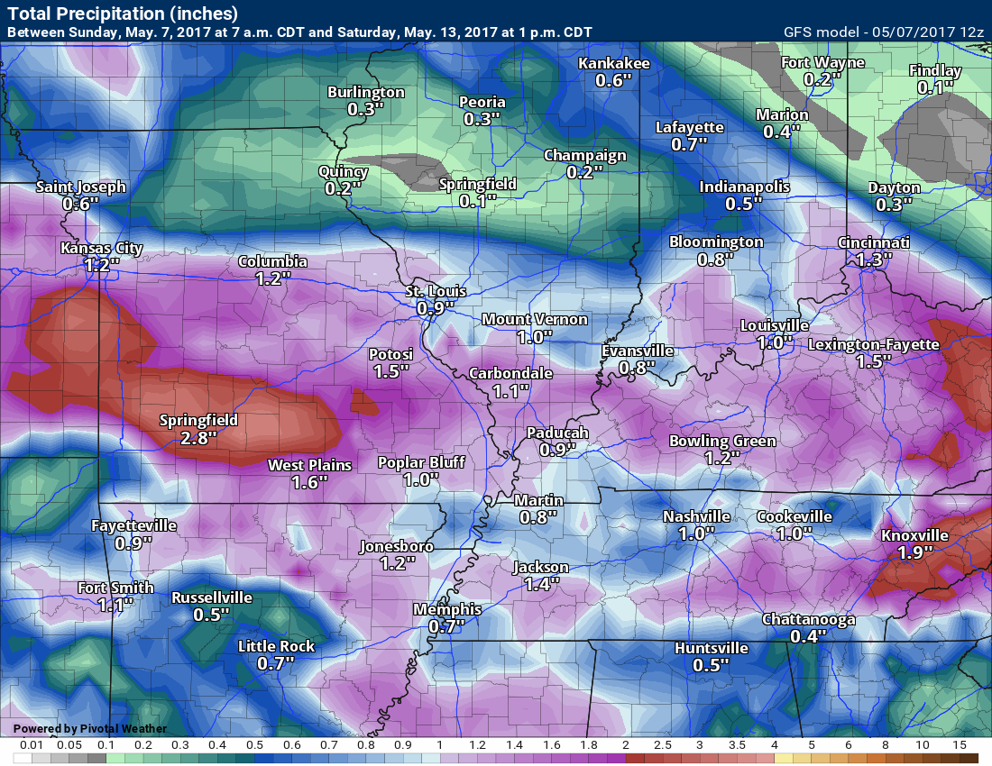
Speaking of recent rainfall totals. Check out these huge numbers from the past couple of weeks. Amazing rainfall totals. Historic event for portions of our region. The widespread nature of the rain is even more incredible.
The severe weather risk this week is not zero, but it is not all that great. That is great news. This is the peak time of the year for tornadoes in our region. Each passing week without an outbreak of severe weather is one week closer to summer. We tend to not have as many severe storms during the summer months.
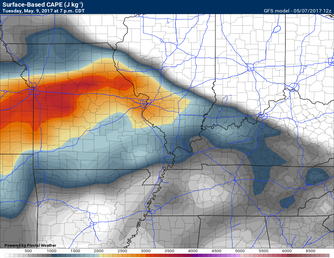
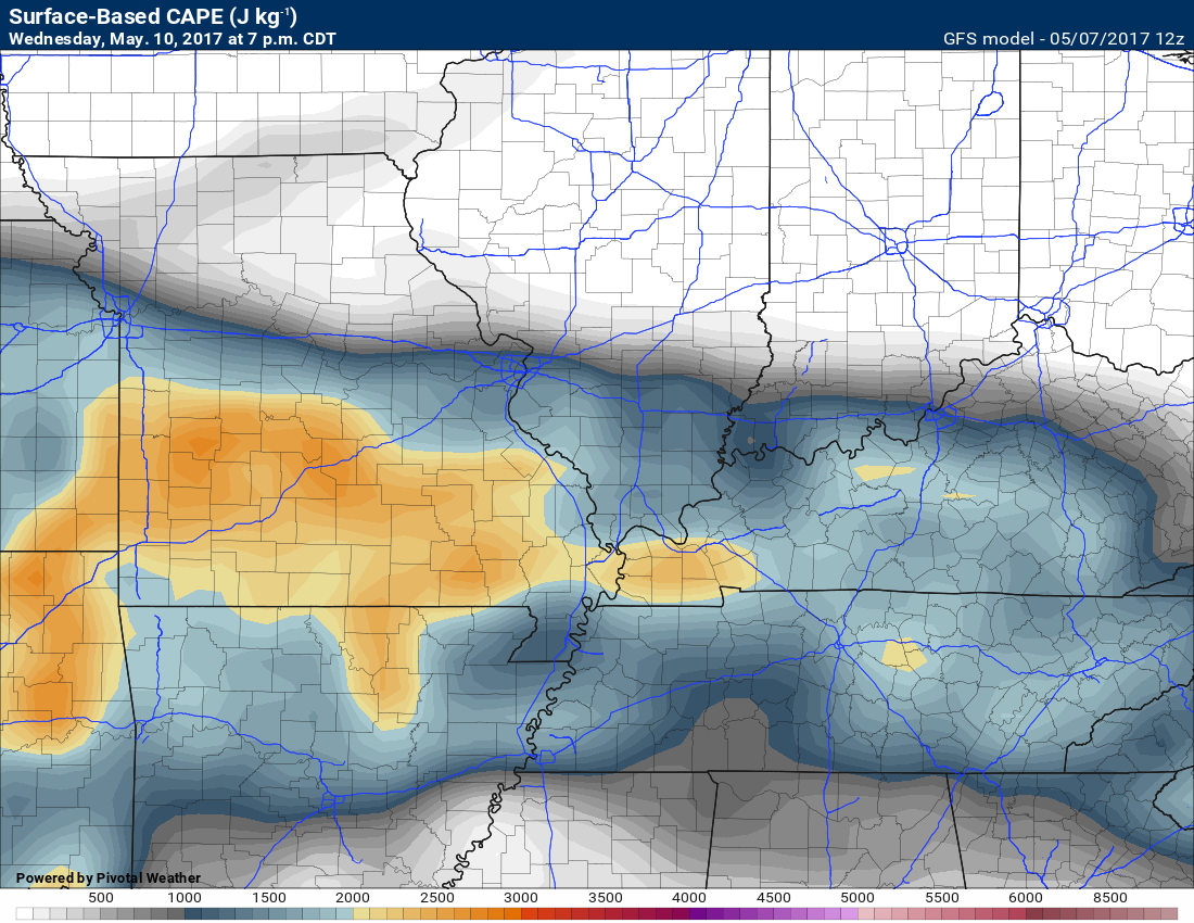
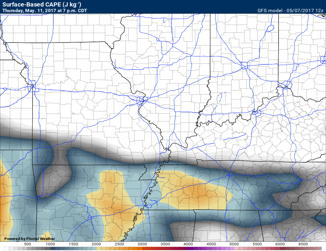
We do have CAPE showing up on Tuesday and Wednesday. More CAPE in the charts for Thursday and Thursday night. CAPE is a measure of instability that forecasters use when looking at severe weather parameters.
Here are some CAPE maps for the week ahead.
as you can see, there is some CAPE for storms to work with. Not extreme numbers. Enough to at least monitor the storm chances moving forward. Perhaps a few strong storms this week.
Tuesday evening
Highest CAPE numbers are from eastern Kansas into central and northern Missouri and then into the St Louis, Missouri area.
Wednesday evening
Thursday evening
Notice the sharp cut off? That is where the front is positioned. Southern portion of our region. South of the front is where CAPE numbers increase.
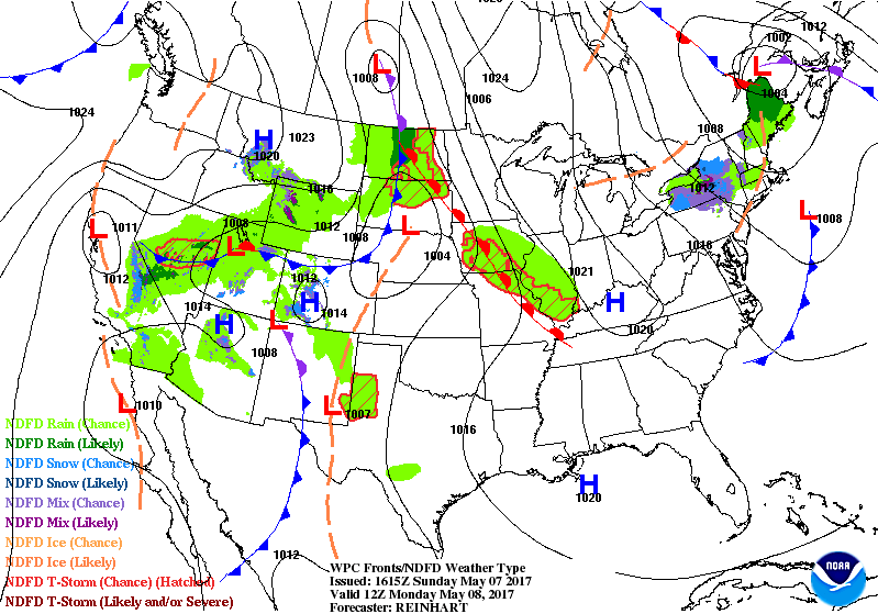
Let’s walk through the week with some weather maps.
This first weather map is for Monday morning. You will notice a warm front in our region. Typically what happens with warm fronts is that a few showers and storms form along and to the north of them.
I have included spotty rain chances for southern Illinois and northwest Kentucky on Monday. See detailed forecast at the top of the blog.
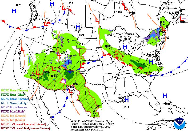
Moving ahead to Tuesday morning (the map below). You can see the warm front has moved northward. It is located from eastern Iowa into central Illinois and then back towards northern Kentucky. Small shower chances in our region on Tuesday.
.
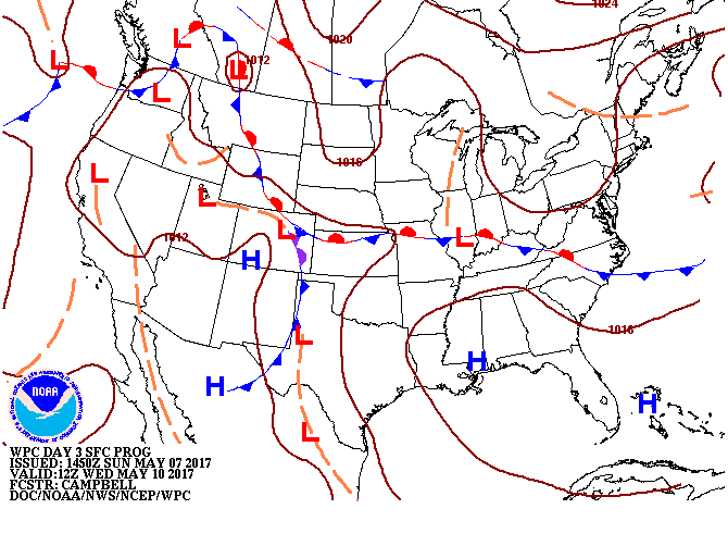
Moving ahead to Wednesday. This is the 7 AM Wednesday map. A weak area of low pressure is centered over southern Illinois. A stationary boundary drapes across Kansas, Missouri, Illinois, and then into Indiana and Kentucky. The placement of the front will be key to shower and thunderstorm chances. The front will slowly move south on Wednesday and Wednesday night. Showers and storms will increase from north to south.
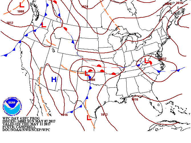
This next weather map is for Thursday morning.
You can see an area of low pressure developing over the Oklahoma Panhandle. Several fronts drape across our region. The area of low pressure will move east.
A good chance for showers and thunderstorms will be with us on Thursday and Thursday night. I doubt it rains all day, but at least some precipitation on radar. We will have to monitor exactly where the front is placed.
.
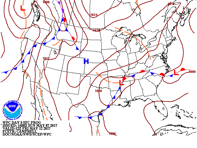
This next map is for Friday. An area of low pressure is located to our south. We should have some rain chances over at least the southern portion of the region Friday. Again, placement of the front will be important as to sensible weather in our region. I have included shower chances for Friday, as well.
.
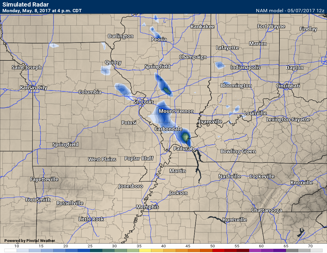
Taking a look at a few future-cast radar images for the coming days. This is what some of the models believe radar will look like this week. Keep in mind this is just a models opinion. Take the general idea from these and not specifics.
Confidence on timing and placement of precipitation is medium.
Monday afternoon future-cast radar does show a couple of showers over eastern Missouri into Illinois. Again, I did include low end chances for showers on Monday for portions of the region (see detailed forecast top of the blog post)
This next image is for Tuesday evening. Remember, the front is further north by Tuesday evening. Thus, the rain chances are a bit further north, as well. Perhaps some chance over our northern counties and then into northwest Kentucky.
This next image is for Wednesday at 7 pm.
Increasing chances for showers and thunderstorms from north to south. The front is moving south.
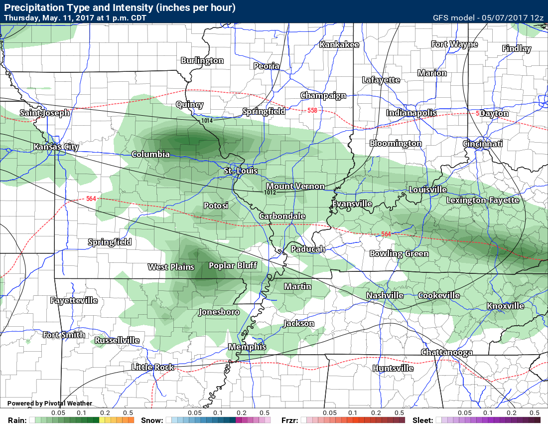
This next map is for Thursday at 1 pm.
The front will be in our region during this time period. A chance for showers and a few thunderstorms.
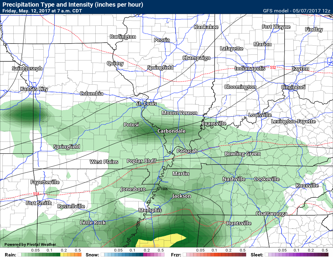
This next map is for Friday at 7 am. The front is shifting southward.
Keep in mind it won’t rain all the time. On and off rain chances this week. Perhaps greatest coverage from Wednesday night into Thursday night.
Rainfall totals from some of the models.
GFS model
GEM model
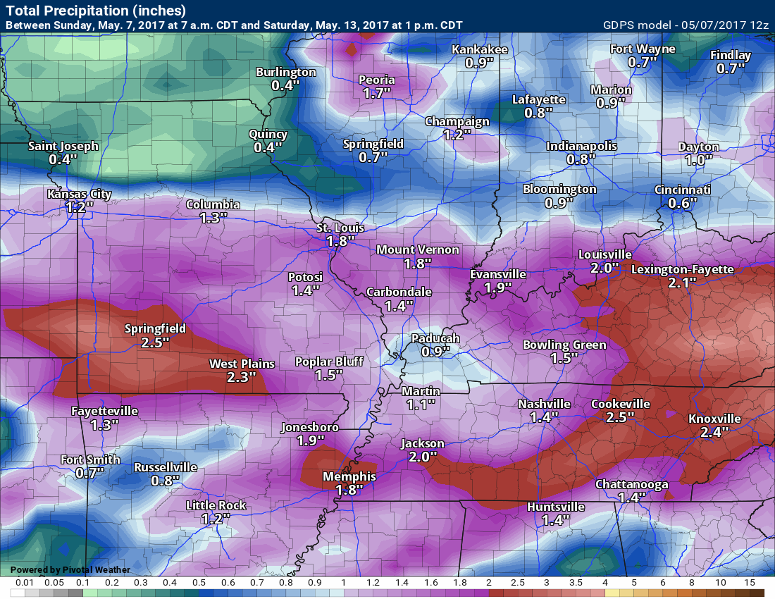
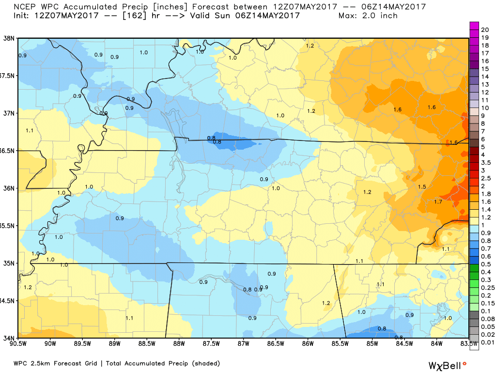
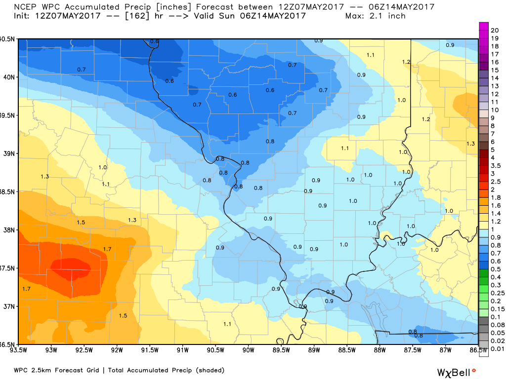
Let’s look at what NOAA is predicting for rainfall totals. This is now through Saturday
Click images for larger views
.

Find me on Twitter

We have regional radars and local city radars – if a radar does not update then try another one. Occasional browsers need their cache cleared. You may also try restarting your browser. That usually fixes the problem. Occasionally we do have a radar go down. That is why I have duplicates. Thus, if one fails then try another one.
During the winter you can track snow and ice by clicking the winterize button on the local city view interactive radars.
If you have any problems then please send me an email beaudodson@usawx.com
Interactive Weather Radar Page. Choose the city nearest your location: Click this link—
National interactive radar: Click this link.
Local interactive city radars include St Louis, Mt Vernon, Evansville, Poplar Bluff, Cape Girardeau, Marion, Paducah, Hopkinsville, Memphis, Nashville, Dyersburg, and all of eastern Kentucky. These are interactive radars. Local city radars – click here
Regional Radar

The official 6-10 day and 8-14 day temperature and precipitation outlook. Check the date stamp at the top of each image (so you understand the time frame).
The forecast maps below are issued by the Weather Prediction Center (NOAA)


The latest 8-14 day temperature and precipitation outlook. Note the dates are at the top of the image. These maps DO NOT tell you how high or low temperatures or precipitation will be. They simply give you the probability as to whether temperatures or precipitation will be above or below normal.


The Beau Dodson Weather APP is ready for Apple and Android users. The purpose of this app is for me to deliver your text messages instantly. ATT and Verizon have not always been reliable when it comes to speed. The app allows instant delivery.
Some of you have asked if you can keep receiving the texts on your phone and the app. The answer to that is, yes. The Android app will automatically allow that to happen. On the Apple app, however, you will need to go into your app and click settings. Make sure the green tab is OFF. Off means you will still receive the texts to your phone and the app. If you have any questions, then email me at beaudodson@usawx.com
The app is for text subscribers.
The direct download, for the Apple app, can be viewed here
https://itunes.apple.com/us/app/id1190136514
If you have not signed up for the texting service then you may do so at www.beaudodsonweather.com

The Android app is also ready.
Remember, the app’s are for www.weathertalk.com subscribers. The app allows your to receive the text messages faster than ATT and Verizon.
Here is the download link for the Android version Click Here

——————————————————–
If you have not signed up for the texts messages, then please do. Link www.beaudodsonweather.com
Your support helps with the following:

and


Who do you trust for your weather information and who holds them accountable?
I have studied weather in our region since the late 1970’s. I have 39 years of experience in observing our regions weather patterns. My degree is in Broadcast Meteorology and a Bachelor’s of Science.
My resume includes:
Member of the American Meteorological Society.
NOAA Weather-Ready Nation Ambassador.
Meteorologist for McCracken County Emergency Management. I served from 2005 through 2015.
Meteorologist for McCracken County Rescue. 2015 through current
I own and operate the Southern Illinois Weather Observatory.
I am the chief meteorologist for Weather Talk LLC. I am the owner of Weather Talk LLC.
I am also a business owner in western Kentucky.
Recipient of the Mark Trail Award, WPSD Six Who Make A Difference Award, Kentucky Colonel, and the Caesar J. Fiamma” Award from the American Red Cross.
In 2005 I helped open the largest American Cross shelter in U.S. history in Houston, Texas. I was deployed to help after Hurricane Katrina and Hurricane Rita. I was a shelter manager of one of the Houston, Texas shelter divisions.
In 2009 I was presented with the Kentucky Office of Highway Safety Award.
Recognized by the Kentucky House of Representatives for my service to the State of Kentucky leading up to several winter storms and severe weather outbreaks.
If you click on the image below you can read the Kentucky House of Representatives Resolution.

I am also President of the Shadow Angel Foundation which serves portions of western Kentucky and southern Illinois.
There is a lot of noise on the internet. A lot of weather maps are posted without explanation. Over time you should learn who to trust for your weather information.
My forecast philosophy is simple and straight forward.
- Communicate in simple terms
- To be as accurate as possible within a reasonable time frame before an event
- Interact with you on Twitter, Facebook, email, texts, and this blog
- Minimize the “hype” that you might see on some television stations or through other weather sources
- Push you towards utilizing wall-to-wall LOCAL TV coverage during severe weather events
Many of the graphics on this page are from www.weatherbell.com
WeatherBell is a great resource for weather model guidance.


You can sign up for my AWARE email by clicking here I typically send out AWARE emails before severe weather, winter storms, or other active weather situations. I do not email watches or warnings. The emails are a basic “heads up” concerning incoming weather conditions