

This forecast update covers far southern Illinois, far southeast Missouri, and far western Kentucky. See the coverage map on the right side of the blog
Friday Night Forecast Details:
Forecast: Any remaining clouds will exit. Then, increasing clouds late tonight form the north for southern Illinois and parts of western Kentucky. Cool temperatures. Breezy.
Temperatures: MO ~ 44 to 48 IL ~ 44 to 48 KY ~ 44 to 48 TN ~ 44 to 48
Winds: West and northwest winds at 7 to 14 mph with gusts to 30 mph
My confidence in the forecast verifying: High
What impacts are anticipated from the weather? None
Is severe weather expected? No
The NWS defines severe weather as 58 mph winds or great, 1″ hail or larger, and/or tornadoes
What is the chance of precipitation? MO ~ 0% IL ~ 0% KY ~ 0% TN ~ 0%
Coverage of precipitation: None
Should I cancel my outdoor plans? No
.
May 6, 2017
Saturday Forecast Details
Forecast: Mix of sun and clouds. A chance for a shower or thunderstorm over southeast Illinois, the Pennyrile area of western Kentucky, and northwest Tennessee. Smaller chances elsewhere. Warmer. Breezy, at times.
Temperatures: MO 73 ~ 76 IL 68 ~ 74 KY 68 ~ 74 TN 68 ~ 74
Winds: West and northwest winds at 12 to 24 mph with gusts to 35 mph.
What impacts are anticipated from the weather? Perhaps some wet roadways. Pea size hail. Lightning possible. Chances for showers might be contained to our far eastern counties.
My confidence in the forecast verifying: Medium. Some adjustments are possible.
Is severe weather expected? No, but pea size hail and gusty winds are possible if a thunderstorm forms.
The NWS defines severe weather as 58 mph winds or great, 1″ hail or larger, and/or tornadoes
What is the chance of precipitation? MO ~ 10% IL ~ 30% KY ~ 40% TN ~ 30%
Coverage of precipitation: Most of the area will be dry. Perhaps a few showers or a thunderstorm with a passing system. Best chances will be east vs west.
Should I cancel my outdoor plans? No, but check radars.
Saturday Night Forecast Details:
Forecast: Clearing. Cool.
Temperatures: MO 42 ~ 48 IL 42 ~ 46 KY 42 ~ 46 TN 44 ~ 48
Winds: Variable winds at 5 to 10 mph
My confidence in the forecast verifying: Medium. Some adjustments possible.
What impacts are anticipated from the weather? None
Is severe weather expected? No
The NWS defines severe weather as 58 mph winds or great, 1″ hail or larger, and/or tornadoes
What is the chance of precipitation? MO ~ 0% IL ~ 0% KY ~ 0% TN ~ 0%
Coverage of precipitation: None
Should I cancel my outdoor plans? No
.
May 7, 2017
Sunday Forecast Details
Forecast: Mostly sunny. A few passing clouds. It should be a nice day. Warmer. Sunday is the pick day of the weekend.
Temperatures: MO ~ 68 to 74 IL 66 to 72 KY 66 to 72 TN 66 to 74
Winds: Variable winds at 5 to 10 mph
What impacts are anticipated from the weather? None
My confidence in the forecast verifying: High. This forecast should verify.
Is severe weather expected? No
The NWS defines severe weather as 58 mph winds or great, 1″ hail or larger, and/or tornadoes
What is the chance of precipitation? MO ~ 0% IL ~ 0% KY ~ 0% TN ~ 0%
Coverage of precipitation: None
Should I cancel my outdoor plans? No
Sunday Night Forecast Details:
Forecast: Mostly clear. Perhaps a few passing clouds.
Temperatures: MO ~ 43 to 46 IL ~ 42 to 46 KY ~ 45 to 50 TN ~ 45 to 50
Winds: East and southeast winds at 4 to 8 mph
My confidence in the forecast verifying: High. This forecast should verify.
What impacts are anticipated from the weather? None
Is severe weather expected? No
The NWS defines severe weather as 58 mph winds or great, 1″ hail or larger, and/or tornadoes
What is the chance of precipitation? MO ~ 0% IL ~ 0% KY ~ 0% TN ~ 0%
Coverage of precipitation: None
Should I cancel my outdoor plans? No
.
May 8, 2017
Monday Forecast Details
Forecast: A mix of sun and clouds. Some guidance shows several bands of clouds in the region. This might impact temperatures.
Temperatures: MO ~ 74 to 78 IL 68 to 74 KY 68 to 74 TN 70 to 75
Winds: Variable winds at 4 to 8 mph with gusts to 12 mph
What impacts are anticipated from the weather? None
My confidence in the forecast verifying: Medium. Some adjustments are possible.
Is severe weather expected? No
The NWS defines severe weather as 58 mph winds or great, 1″ hail or larger, and/or tornadoes
What is the chance of precipitation? MO ~ 0% IL ~ 0% KY ~ 0% TN ~ 0%
Coverage of precipitation: None
Should I cancel my outdoor plans? No
Monday Night Forecast Details:
Forecast: Partly cloudy. Not as cool as recent nights.
Temperatures: MO ~ 54 to 58 IL ~ 54 to 58 KY ~ 54 to 58 TN ~ 54 to 58
Winds: South and southeast winds at 4 to 8 mph
My confidence in the forecast verifying: High. This forecast should verify.
What impacts are anticipated from the weather? None
Is severe weather expected? No
The NWS defines severe weather as 58 mph winds or great, 1″ hail or larger, and/or tornadoes
What is the chance of precipitation? MO ~ 0% IL ~ 0% KY ~ 0% TN ~ 0%
Coverage of precipitation: None
Should I cancel my outdoor plans? No
.
May 9, 2017
Tuesday Forecast Details
Forecast: Mostly sunny. Warmer.
Temperatures: MO ~ 75 to 80 IL 75 to 80 KY 75 to 80 TN 75 to 80
Winds: South and southwest at 5 to 10 mph
What impacts are anticipated from the weather? None
My confidence in the forecast verifying: High. This forecast should verify.
Is severe weather expected? No
The NWS defines severe weather as 58 mph winds or great, 1″ hail or larger, and/or tornadoes
What is the chance of precipitation? MO ~ 0% IL ~ 0% KY ~ 0% TN ~ 0%
Coverage of precipitation: None
Should I cancel my outdoor plans? No
Tuesday Night Forecast Details:
Forecast: Mostly clear. Perhaps a few late night clouds.
Temperatures: MO ~ 56 to 62 IL ~ 56 to 62 KY ~ 56 to 62 TN ~ 58 to 62
Winds: South and southwest winds at 5 to 10 mph
My confidence in the forecast verifying: High. This forecast should verify.
What impacts are anticipated from the weather? None
Is severe weather expected? No
The NWS defines severe weather as 58 mph winds or great, 1″ hail or larger, and/or tornadoes
What is the chance of precipitation? MO ~ 0% IL ~ 0% KY ~ 0% TN ~ 0%
Coverage of precipitation: None
Should I cancel my outdoor plans? No
.

Don’t forget to check out the Southern Illinois Weather Observatory web-site for weather maps, tower cams, scanner feeds, radars, and much more! Click here

An explanation of what is happening in the atmosphere over the coming day

Severe thunderstorm outlook.
Remember that a severe thunderstorm is defined as a thunderstorm that produces 60 mph winds or higher, quarter size hail or larger, and/or a tornado.
Friday night: Severe weather is not anticipated. Flooding will continue in many areas. Monitor lake and river stage forecasts. Many rivers are flooding.
Saturday through Monday night: Severe weather is not anticipated. I can’t rule out a thunderstorm on Saturday. This is mainly for southeast Illinois, Kentucky, and Tennessee. Pea size hail and gusty winds possible. Lightning, of course.
—————————————————————————-
Weather analysis for the next few days:
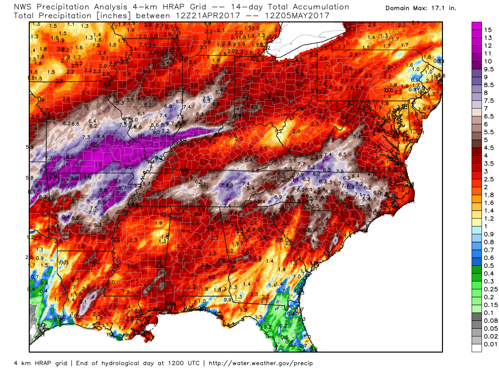
How much rain has fallen the last 14 days. Insane amounts of rain.
Click images for the full view
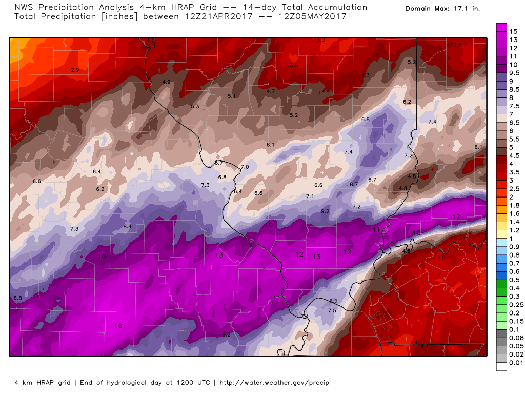
Southeast view of our area
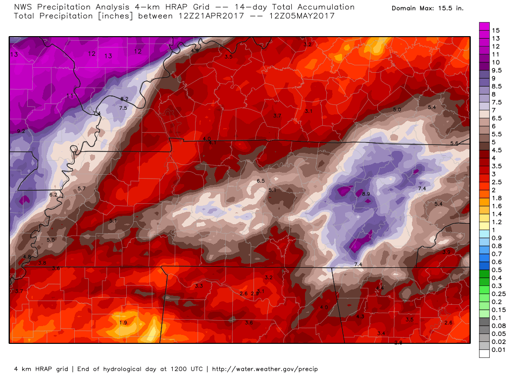
Regional view
The main weather story over the weekend will be a calming of the winds and somewhat milder temperatures.
A weak weather system will quickly move through the region on Saturday morning and afternoon. This system will approach from the north and move south.
A band of showers and perhaps thunderstorms could accompany this system. There is some debate about whether to keep the rain chances out of our local area vs placing them further east. See the images below.
If a storm forms then it could produce gusty winds and small hail.
We do have some CAPE on Saturday. CAPE is a measure of energy for storms to tap into.
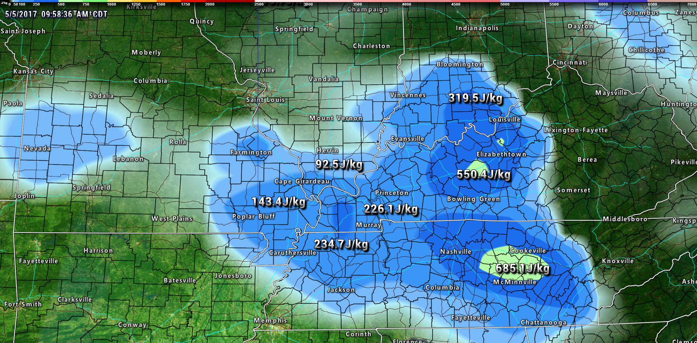
I have included rain chances in the forecast for Saturday (for portions of the area). Again, the greatest risk would be southeast Illinois into the Pennyrile area of western Kentucky. Lesser chances elsewhere.
I will cap the rain chances at 30%-40%.
That system will move off to the south by Saturday evening. This will leave us with clear sky conditions for Saturday night. Mostly sunny for Sunday. Mostly clear for Sunder night.
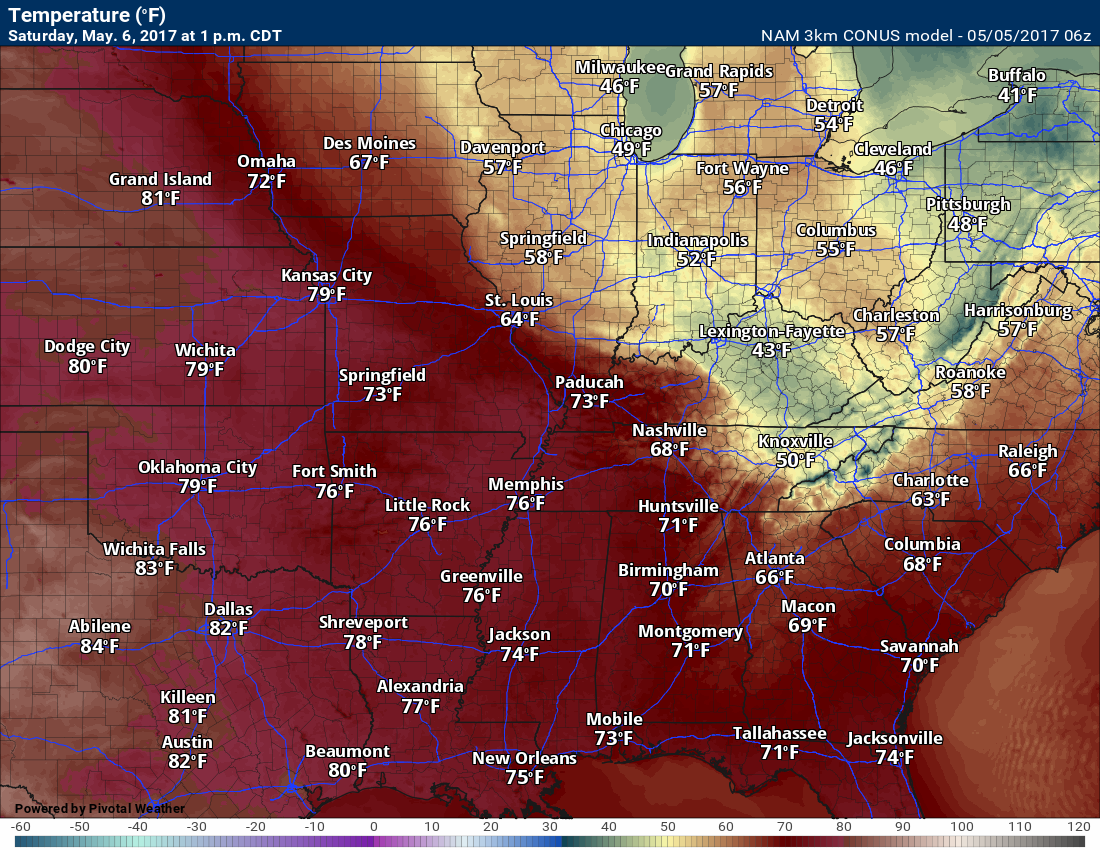
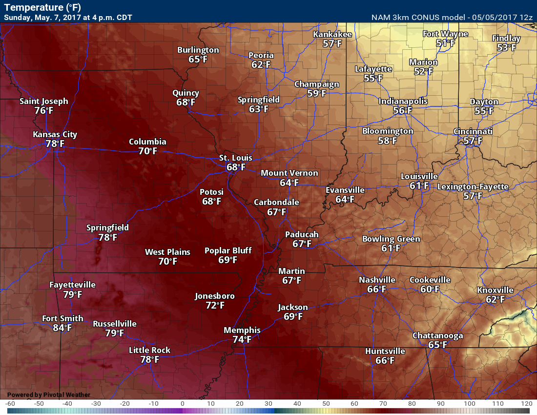
Temperatures will slowly moderate as we move into the weekend. Highs will mostly be in the 60’s on Saturday. Poplar Bluff may reach 70 degrees. Temperatures on Sunday should pop into the upper 60’s to lower 70’s. Sunday is the pick day of the weekend.
Monday and Tuesday should be dry.
I am monitoring another storm system for Wednesday and Thursday. At this time, it appears an area of low pressure will push out of the central United States. It might move to our south. The GFS shows the area of low pressure passing to our south. Not ready to bite on one solution over another, but if it does move to our south then that keeps us on the cool side of the event. That would mean no risk for severe storms. Again, a bit early for confidence.
Let’s look at some weather maps
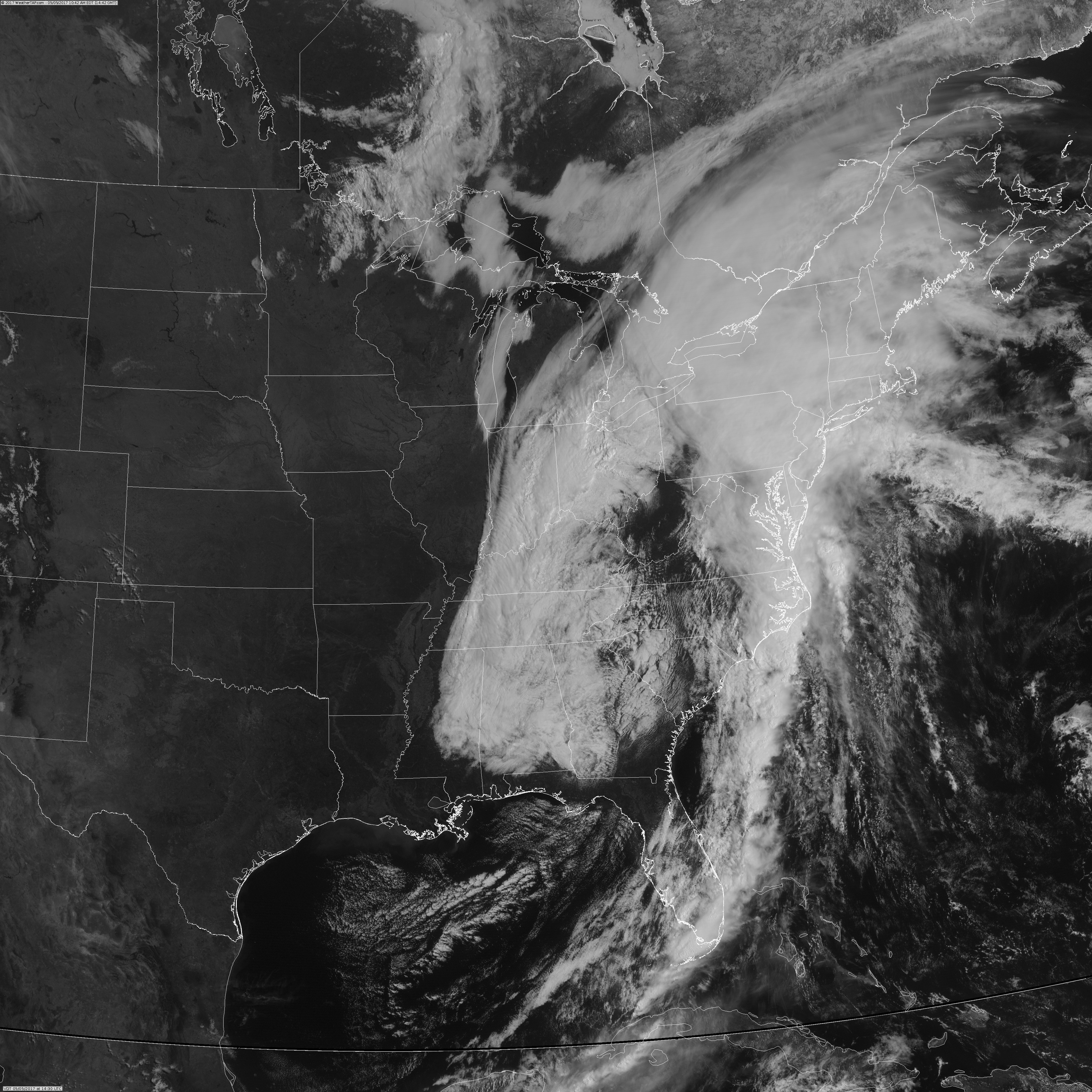
Amazing satellite image from Friday. Look at that sharp cut-off in clouds from west to east. You can almost envision the spiral around the upper level low.
Click the images for larger views
Large image
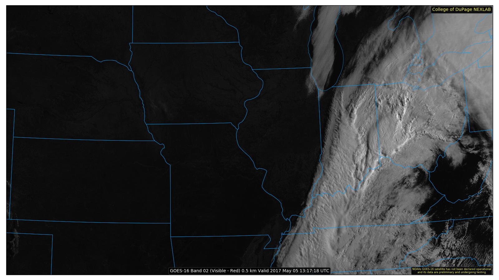
Another view. Large images.
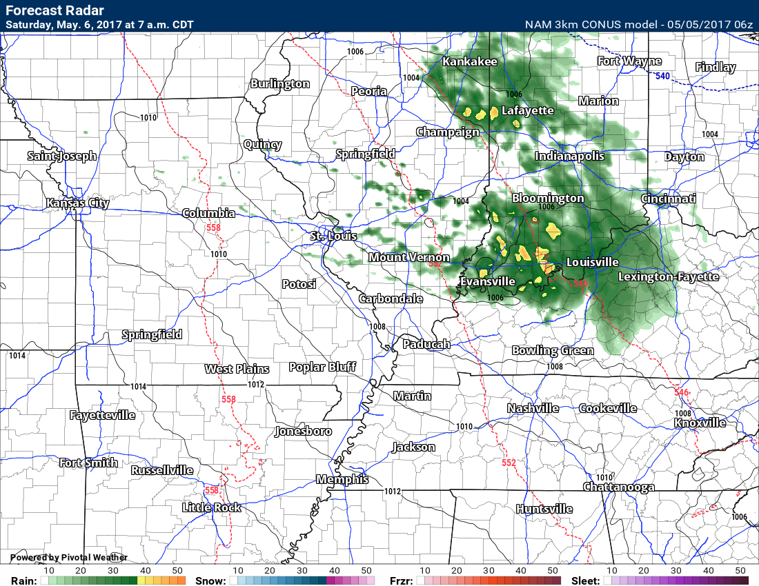
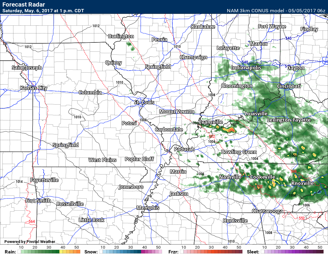
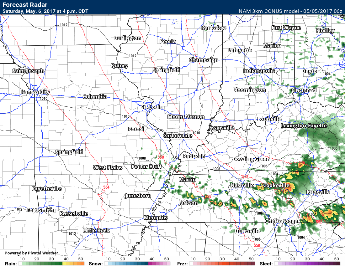
Let’s take a look at the 3K NAM high resolution model future-cast radar for Saturday
Remember, this is a model. This is guidance and not gospel. It is one model’s opinion on what might happen Saturday.
Some showers are possible in our area. If the system is slightly further east then we would likely miss out on the rain chances.
The best chance for rain will be over southeast Illinois, the Pennyrile area of western Kentucky, and Tennessee.
Version:1.0 StartHTML:000000231 EndHTML:000003010 StartFragment:000002659 EndFragment:000002960 StartSelection:000002659 EndSelection:000002956 SourceURL:http://talk.weathertalk.com/wp-admin/post.php?post=24053&action=edit
This image is for 7 am Saturday
This image is for 1 pm on Saturday
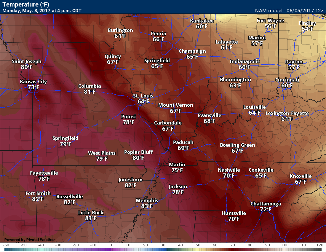
This image is for 4 pm Saturday
Saturday temperatures (below) are highly dependent on cloud cover.
Sunday afternoon temperatures. Nice day.
Cloud forecast map for Monday. We will see if this happens. Confidence on clouds is low. It would impact temperatures.
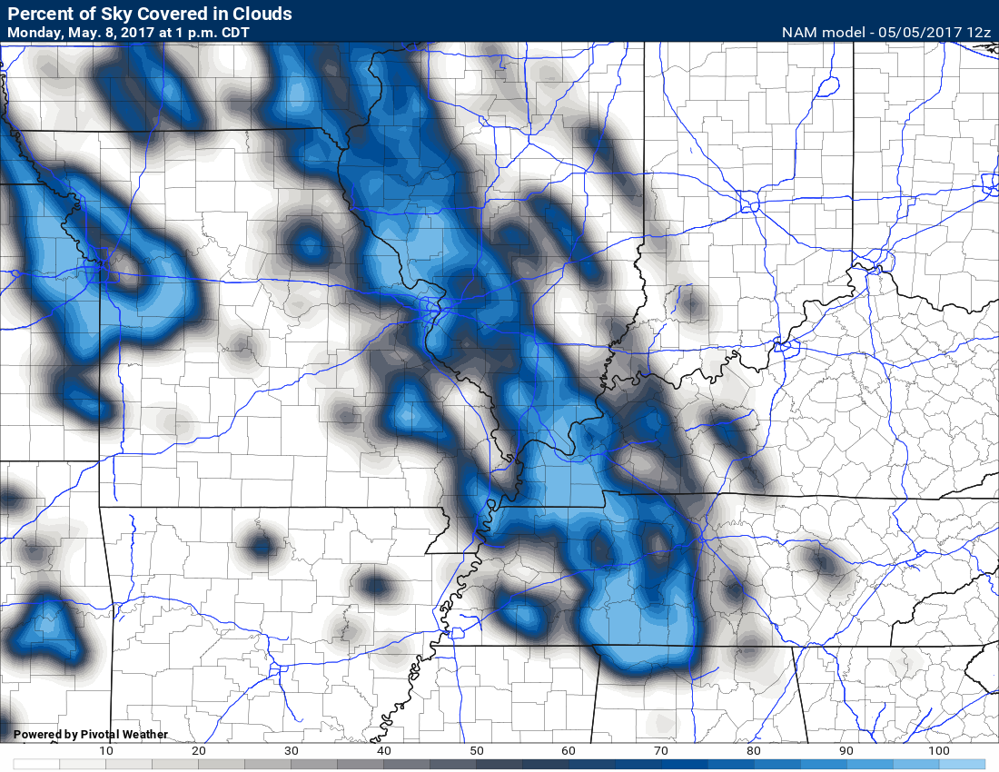
Here is the temperature map for Monday. Notice the big difference in temperatures? That would be because of clouds.
Confidence on clouds is low. No clouds and everyone is warm.
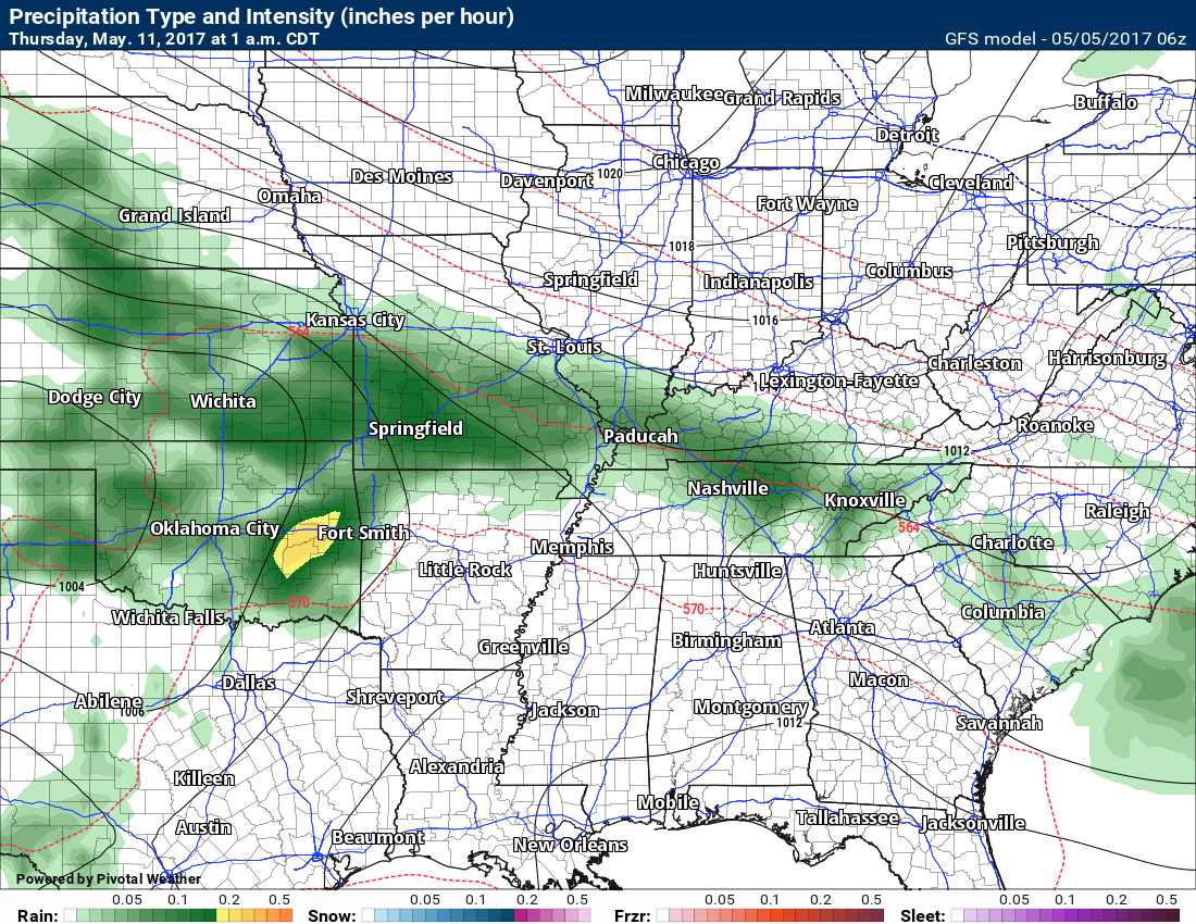
I am watching another system for Wednesday/Thursday. Rain chances would increase if this is correct.
This graphic is for Wednesday night.
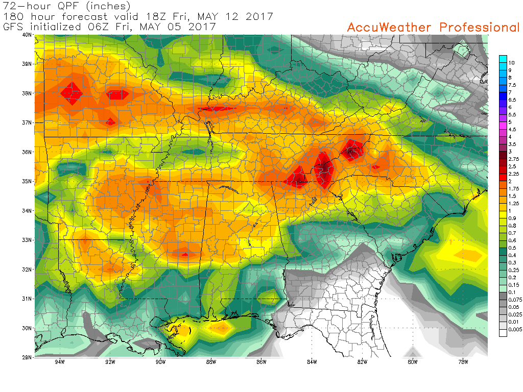
Here is what the EC and GFS models are showing for rainfall totals on the Wednesday night into Thursday night event
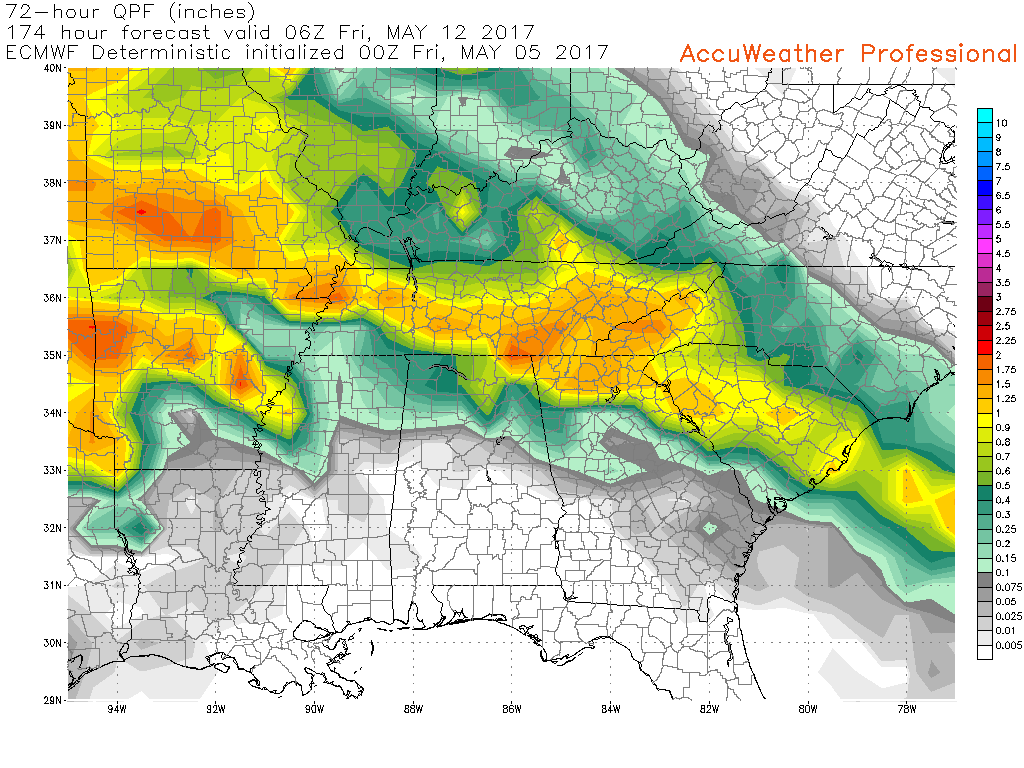
and

Find me on Twitter

We have regional radars and local city radars – if a radar does not update then try another one. Occasional browsers need their cache cleared. You may also try restarting your browser. That usually fixes the problem. Occasionally we do have a radar go down. That is why I have duplicates. Thus, if one fails then try another one.
During the winter you can track snow and ice by clicking the winterize button on the local city view interactive radars.
If you have any problems then please send me an email beaudodson@usawx.com
Interactive Weather Radar Page. Choose the city nearest your location: Click this link—
National interactive radar: Click this link.
Local interactive city radars include St Louis, Mt Vernon, Evansville, Poplar Bluff, Cape Girardeau, Marion, Paducah, Hopkinsville, Memphis, Nashville, Dyersburg, and all of eastern Kentucky. These are interactive radars. Local city radars – click here
Regional Radar

The official 6-10 day and 8-14 day temperature and precipitation outlook. Check the date stamp at the top of each image (so you understand the time frame).
The forecast maps below are issued by the Weather Prediction Center (NOAA)


The latest 8-14 day temperature and precipitation outlook. Note the dates are at the top of the image. These maps DO NOT tell you how high or low temperatures or precipitation will be. They simply give you the probability as to whether temperatures or precipitation will be above or below normal.


The Beau Dodson Weather APP is ready for Apple and Android users. The purpose of this app is for me to deliver your text messages instantly. ATT and Verizon have not always been reliable when it comes to speed. The app allows instant delivery.
Some of you have asked if you can keep receiving the texts on your phone and the app. The answer to that is, yes. The Android app will automatically allow that to happen. On the Apple app, however, you will need to go into your app and click settings. Make sure the green tab is OFF. Off means you will still receive the texts to your phone and the app. If you have any questions, then email me at beaudodson@usawx.com
The app is for text subscribers.
The direct download, for the Apple app, can be viewed here
https://itunes.apple.com/us/app/id1190136514
If you have not signed up for the texting service then you may do so at www.beaudodsonweather.com

The Android app is also ready.
Remember, the app’s are for www.weathertalk.com subscribers. The app allows your to receive the text messages faster than ATT and Verizon.
Here is the download link for the Android version Click Here

——————————————————–
If you have not signed up for the texts messages, then please do. Link www.beaudodsonweather.com
Your support helps with the following:

and


Who do you trust for your weather information and who holds them accountable?
I have studied weather in our region since the late 1970’s. I have 39 years of experience in observing our regions weather patterns. My degree is in Broadcast Meteorology and a Bachelor’s of Science.
My resume includes:
Member of the American Meteorological Society.
NOAA Weather-Ready Nation Ambassador.
Meteorologist for McCracken County Emergency Management. I served from 2005 through 2015.
Meteorologist for McCracken County Rescue. 2015 through current
I own and operate the Southern Illinois Weather Observatory.
I am the chief meteorologist for Weather Talk LLC. I am the owner of Weather Talk LLC.
I am also a business owner in western Kentucky.
Recipient of the Mark Trail Award, WPSD Six Who Make A Difference Award, Kentucky Colonel, and the Caesar J. Fiamma” Award from the American Red Cross.
In 2005 I helped open the largest American Cross shelter in U.S. history in Houston, Texas. I was deployed to help after Hurricane Katrina and Hurricane Rita. I was a shelter manager of one of the Houston, Texas shelter divisions.
In 2009 I was presented with the Kentucky Office of Highway Safety Award.
Recognized by the Kentucky House of Representatives for my service to the State of Kentucky leading up to several winter storms and severe weather outbreaks.
If you click on the image below you can read the Kentucky House of Representatives Resolution.

I am also President of the Shadow Angel Foundation which serves portions of western Kentucky and southern Illinois.
There is a lot of noise on the internet. A lot of weather maps are posted without explanation. Over time you should learn who to trust for your weather information.
My forecast philosophy is simple and straight forward.
- Communicate in simple terms
- To be as accurate as possible within a reasonable time frame before an event
- Interact with you on Twitter, Facebook, email, texts, and this blog
- Minimize the “hype” that you might see on some television stations or through other weather sources
- Push you towards utilizing wall-to-wall LOCAL TV coverage during severe weather events
Many of the graphics on this page are from www.weatherbell.com
WeatherBell is a great resource for weather model guidance.


You can sign up for my AWARE email by clicking here I typically send out AWARE emails before severe weather, winter storms, or other active weather situations. I do not email watches or warnings. The emails are a basic “heads up” concerning incoming weather conditions