
.

This forecast update covers far southern Illinois, far southeast Missouri, and far western Kentucky. See the coverage map on the right side of the blog.
May 29, 2017
Monday Night Forecast Details:
Forecast: Patchy late night fog. A period of partly to mostly cloudy sky conditions with a 30% to 40% for scattered showers and thunderstorms. Decent temperatures for late May.
Temperatures: MO ~ 56 to 62 IL ~ 56 to 62 KY ~ 56 to 62 TN ~ 58 to 62
Winds: West and northwest winds at 3 to 6 mph with gusts to 10 mph.
My confidence in the forecast verifying: High. This forecast should verify.
What impacts are anticipated from the weather? A few storms could cause wet roadways and lightning. Pea size hail.
Is severe weather expected? No
The NWS defines severe weather as 58 mph winds or great, 1″ hail or larger, and/or tornadoes
What is the chance of precipitation? MO ~ 30% IL ~ 30% KY ~ 40% TN ~ 30%
Coverage of precipitation: Isolated to perhaps scattered
Should I cancel my outdoor plans? No, but check radars.
.
May 30, 2017
Tuesday Forecast Details
Forecast: Perhaps some morning patchy fog. Partly sunny. A 30% for morning storms. A few afternoons storms possible.
Temperatures: MO ~ 78 to 84 IL 78 to 82 KY 80 to 84 TN 80 to 84
Winds: West and southwest winds at 3 to 6 mph with gusts to 10 mph.
What impacts are anticipated from the weather? Wet roadways and lightning
My confidence in the forecast verifying: High. This forecast should verify.
Is severe weather expected? No.
The NWS defines severe weather as 58 mph winds or great, 1″ hail or larger, and/or tornadoes
What is the chance of precipitation? MO ~ 30% IL ~ 30% KY ~ 30% TN ~ 30%
Coverage of precipitation: Isolated morning and then scattered afternoon
Should I cancel my outdoor plans? Check radars
.
Tuesday Night Forecast Details:
Forecast: Partly cloudy. A chance of a shower or thunderstorm.
Temperatures: MO ~ 55 to 60 IL ~ 55 to 60 KY ~ 55 to 60 TN ~ 55 to 60
Winds: West and northwest winds at 3 to 6 mph with gusts to 10 mph.
My confidence in the forecast verifying: Medium. Some adjustments are possible.
What impacts are anticipated from the weather? Wet roadways. Lightning.
Is severe weather expected? No
The NWS defines severe weather as 58 mph winds or great, 1″ hail or larger, and/or tornadoes
What is the chance of precipitation? MO ~ 30% IL ~ 30% KY ~ 20% TN ~ 20%
Coverage of precipitation: Widely scattered.
Should I cancel my outdoor plans? No
.
May 31, 2017
Wednesday Forecast Details
Forecast: Partly sunny. A few scattered showers and thunderstorms.
Temperatures: MO ~ 78 to 84 IL 78 to 84 KY 78 to 84 TN 78 to 82
Winds: West and northwest winds at 5 to 10 mph.
What impacts are anticipated from the weather? There is a chance for scattered wet roadways and lightning.
My confidence in the forecast verifying: Medium. Some adjustments are possible.
Is severe weather expected? No.
The NWS defines severe weather as 58 mph winds or great, 1″ hail or larger, and/or tornadoes
What is the chance of precipitation? MO ~ 30% IL ~ 30% KY ~ 20% TN ~ 20%
Coverage of precipitation: Scattered.
Should I cancel my outdoor plans? No
.
Wednesday Night Forecast Details:
Forecast: Mostly clear to partly cloudy.
Temperatures: MO ~ 56 to 62 IL ~ 56 to 62 KY ~ 56 to 62 TN ~ 56 to 62
Winds: Variable at 4 to 8 mph.
My confidence in the forecast verifying: Medium. Some adjustments are possible.
What impacts are anticipated from the weather? Most likely none.
Is severe weather expected? No.
The NWS defines severe weather as 58 mph winds or great, 1″ hail or larger, and/or tornadoes
What is the chance of precipitation? MO ~ 10% IL ~ 10% KY ~ 10% TN ~ 10%
Coverage of precipitation: Isolated.
Should I cancel my outdoor plans? No
.
June 1, 2017
Thursday Forecast Details
Forecast: Partly to mostly cloudy. A chance for showers and thunderstorms.
Temperatures: MO ~ 80 to 84 IL 80 to 84 KY 80 to 84 TN 80 to 84
Winds: South and southeast 6 to 12 mph with gusts to 16 mph.
What impacts are anticipated from the weather? Wet roadways and lightning.
My confidence in the forecast verifying: Medium. Some adjustments are possible.
Is severe weather expected? No.
The NWS defines severe weather as 58 mph winds or great, 1″ hail or larger, and/or tornadoes
What is the chance of precipitation? MO ~ 60% IL ~ 50% KY ~ 50% TN ~ 50%
Coverage of precipitation: Scattered to perhaps numerous, at times.
Should I cancel my outdoor plans? No, not yet. I would monitor updated forecasts and check radars.
.
Thursday Night Forecast Details:
Forecast: Partly cloudy. A few showers and thunderstorms possible.
Temperatures: MO ~ 65 to 70 IL ~ 65 to 70 KY ~ 65 to 70 TN ~ 65 to 70
Winds: South and southwest winds at 6 to 12 mph.
My confidence in the forecast verifying: Medium. Some adjustments are possible.
What impacts are anticipated from the weather? Perhaps some wet roadways and lightning.
Is severe weather expected? No.
The NWS defines severe weather as 58 mph winds or great, 1″ hail or larger, and/or tornadoes
What is the chance of precipitation? MO ~ 30% IL ~ 30% KY ~ 30% TN ~ 30%
Coverage of precipitation: Isolated to perhaps scattered.
Should I cancel my outdoor plans? No
.
June 2, 2017
Friday Forecast Details
Forecast: Quite a few clouds. Showers and thunderstorms possible.
Temperatures: MO ~ 78 to 84 IL 78 to 84 KY 78 to 84 TN 78 to 84
Winds: South and southwest winds at 10 to 20 mph.
What impacts are anticipated from the weather? Wet roadways and lightning.
My confidence in the forecast verifying: Medium. Some adjustments are possible.
Is severe weather expected? Not at this time. Monitor updates.
The NWS defines severe weather as 58 mph winds or great, 1″ hail or larger, and/or tornadoes
What is the chance of precipitation? MO ~ 60% IL ~ 60% KY ~ 60% TN ~ 60%
Coverage of precipitation: Perhaps numerous.
Should I cancel my outdoor plans? Monitor updates.
.
Friday Night Forecast Details:
Forecast: Mostly cloudy. A chance for showers and thunderstorms.
Temperatures: MO ~ 65 to 70 IL ~ 65 to 70 KY ~ 65 to 70 TN ~ 65 to 70
Winds: South at 6 to 12 mph with gusts to 18 mph.
My confidence in the forecast verifying: Medium. Some adjustments are possible.
What impacts are anticipated from the weather? Wet roadways. Lightning.
Is severe weather expected? Not at this time, but monitor updates.
The NWS defines severe weather as 58 mph winds or great, 1″ hail or larger, and/or tornadoes
What is the chance of precipitation? MO ~ 60% IL ~ 60% KY ~ 60% TN ~ 60%
Coverage of precipitation: Scattered to perhaps numerous.
Should I cancel my outdoor plans? Monitor updates.
.
June 3, 2017
Saturday Forecast Details
Forecast: Mostly cloudy. A chance for showers and thunderstorms.
Temperatures: MO ~ 75 to 80 IL 75 to 80 KY 78 to 84 TN 78 to 82
Winds: South and southwest winds at 5 to 10 mph with gusts to 15 mph
What impacts are anticipated from the weather? Perhaps wet roadways and lightning.
My confidence in the forecast verifying: Low. Significant adjustments are likely.
Is severe weather expected? Monitor updated forecasts.
The NWS defines severe weather as 58 mph winds or great, 1″ hail or larger, and/or tornadoes
What is the chance of precipitation? MO ~ 50% IL ~ 50% KY ~ 50% TN ~ 50%
Coverage of precipitation: Scattered to perhaps numerous.
Should I cancel my outdoor plans? Monitor updated forecasts.
.
Saturday Night Forecast Details:
Forecast: Mostly cloudy. A chance for showers and thunderstorms.
Temperatures: MO ~ 55 to 60 IL ~ 55 to 60 KY ~ 55 to 60 TN ~ 55 to 60
Winds: South and southwest at 5 to 10 mph with gusts to 12 mph.
My confidence in the forecast verifying: Low. Significant adjustments are likely.
What impacts are anticipated from the weather? Wet roadways. Lightning.
Is severe weather expected? Unlikely, but monitor future updates.
The NWS defines severe weather as 58 mph winds or great, 1″ hail or larger, and/or tornadoes
What is the chance of precipitation? MO ~ 40% IL ~ 40% KY ~ 40% TN ~ 40%
Coverage of precipitation: Scattered
Should I cancel my outdoor plans? No, but monitor updated forecasts.
.
June 4, 2017
Sunday Forecast Details
Forecast: Partly sunny. A chance for a shower or thunderstorm.
Temperatures: MO ~ 78 to 84 IL 78 to 84 KY 78 to 84 TN 78 to 84
Winds: West and southwest winds at 5 to 10 mph.
What impacts are anticipated from the weather? Perhaps some wet roadways and lightning.
My confidence in the forecast verifying: Medium. Some adjustments are possible.
Is severe weather expected? No.
The NWS defines severe weather as 58 mph winds or great, 1″ hail or larger, and/or tornadoes
What is the chance of precipitation? MO ~ 30% IL ~ 30% KY ~ 30% TN ~ 30%
Coverage of precipitation: Scattered.
Should I cancel my outdoor plans? No, but monitor updates moving forward.
.
Sunday Night Forecast Details:
Forecast: Partly cloudy.
Temperatures: MO ~ 60 to 65 IL ~ 60 to 65 KY ~ 60 to 65 TN ~ 60 to 65
Winds: West and northwest winds at 5 mph.
My confidence in the forecast verifying: Medium. Some adjustments are possible.
What impacts are anticipated from the weather? Most likely none.
Is severe weather expected? No.
The NWS defines severe weather as 58 mph winds or great, 1″ hail or larger, and/or tornadoes
What is the chance of precipitation? MO ~ 20% IL ~ 20% KY ~ 20% TN ~ 20%
Coverage of precipitation: None to isolated.
Should I cancel my outdoor plans? No
.
June 5, 2017
Monday Forecast Details
Forecast: Partly sunny.
Temperatures: MO ~ 78 to 84 IL 78 to 84 KY 78 to 84 TN 78 to 84
Winds: West winds at 5 to 10 mph.
What impacts are anticipated from the weather? Most likely none.
My confidence in the forecast verifying: Low. Significant adjustments are likely.
Is severe weather expected? No.
The NWS defines severe weather as 58 mph winds or great, 1″ hail or larger, and/or tornadoes
What is the chance of precipitation? MO ~ 0% IL ~ 0% KY ~ 0% TN ~ 0%
Coverage of precipitation: Most likely none.
Should I cancel my outdoor plans? No
.
Monday Night Forecast Details:
Forecast: Mostly clear to partly cloudy.
Temperatures: MO ~ 58 to 64 IL ~ 58 to 64 KY ~ 58 to 64 TN ~ 58 to 64
Winds: West and northwest winds at 5 mph.
My confidence in the forecast verifying: Low. Significant adjustments are likely.
What impacts are anticipated from the weather? Most likely none.
Is severe weather expected? No.
The NWS defines severe weather as 58 mph winds or great, 1″ hail or larger, and/or tornadoes
What is the chance of precipitation? MO ~ 0% IL ~ 0% KY ~ 0% TN ~ 0%
Coverage of precipitation: Most likely none.
Should I cancel my outdoor plans? No
.
Don’t forget to check out the Southern Illinois Weather Observatory web-site for weather maps, tower cams, scanner feeds, radars, and much more! Click here
..

A severe thunderstorm is defined as a storm that produces quarter size hail or larger, 58 mph winds or greater, and/or a tornado. That is the official National Weather Service definition of a severe thunderstorm.
Monday night through Friday: We will have on and off thunderstorm chances over the next seven days. See detailed forecast above. At this time severe weather appears unlikely. Locally heavy downpours are possible on Friday into Saturday.

Weather Analysis for the coming week:
Interactive Weather Radar Page. Choose the city nearest your location: Click this link
Monday night:
A weak cold front will pass through the area. There might be a few showers and thunderstorms form along the leading edge of the front. Most areas will remain dry. A few areas might pick up 0.05″ to 0.15″ of rain. Not much.
Decent temperatures for your Monday night, as well. Tuesday morning lows will range from the upper 50’s to lower 60’s.
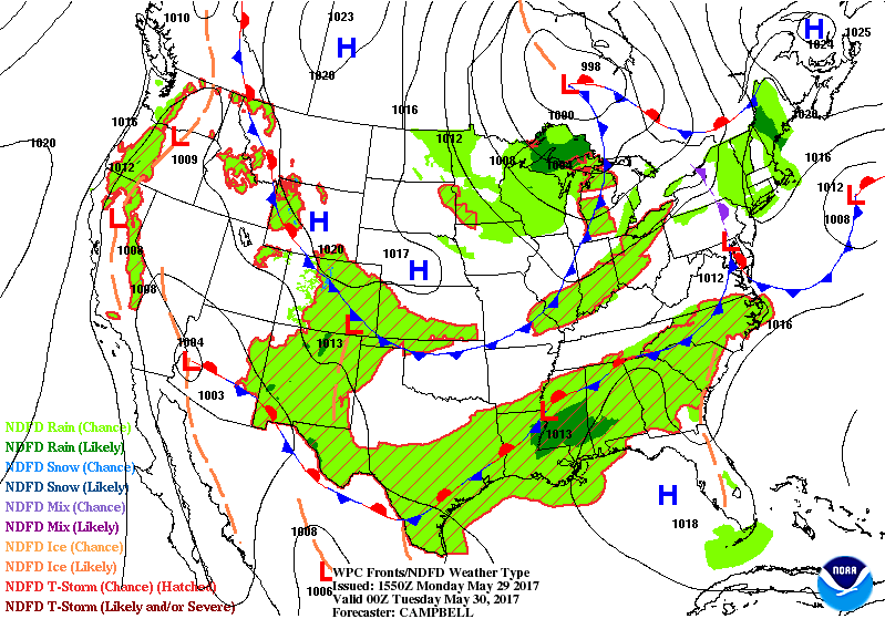
Here is the weak cold front for Tuesday night. You can see it here on the surface map.
Tuesday and Tuesday night:
A decent day on tap for the region with plenty of sunshine. A few passing clouds. Rain chances should hold off until Tuesday night and even then the chances for precipitation are low.
I can’t rule out a few showers and maybe a thundershower. Rainfall totals will be light. Less than 0.25″. Many areas may remain dry.
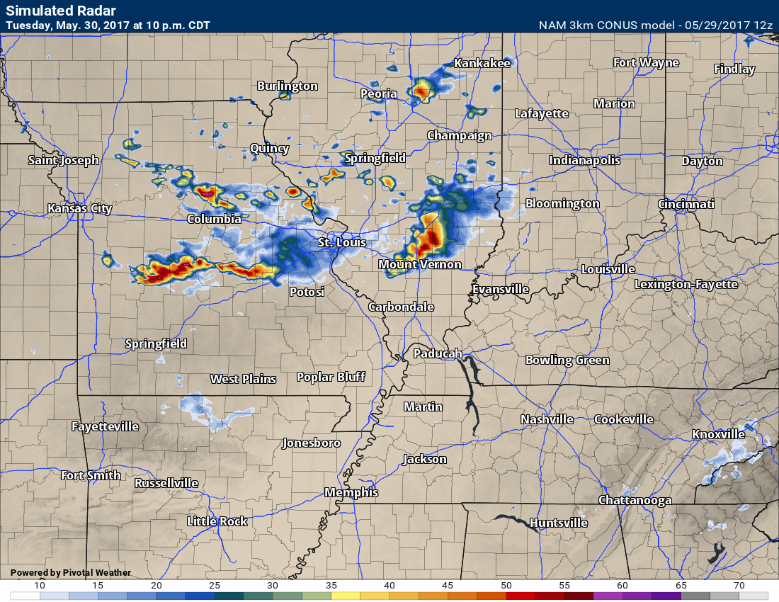
Here is the future-cast radar for 10 pm on Tuesday.
There might be a few showers and storms on radar.
Remember, this is a model. It won’t be exact. Just take the general idea. A few showers/storms possible.
Warm temperatures on Tuesday with highs mostly in the 80’s. Nice weather for late May.
Wednesday into Thursday night:
We will have scattered precipitation chances on Wednesday through Thursday night. Perhaps the highest chance for precipitation will arrive on Thursday. That is the day when chances might rise above 50%. Still some time for adjustments, but if you have outdoor plans you might want to keep that in mind.
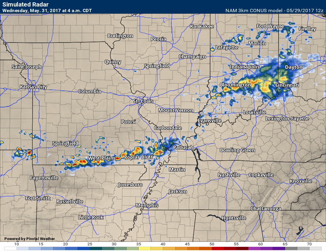
Here is the future-cast NAM radar for 4 am on Wednesday. Maybe some showers and storms? Possible.
Again, one models opinion on placement of rain showers.
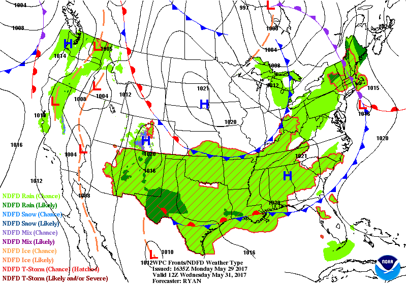
Here is the 7 am weather map for Wednesday morning. You can see the cold front in our local area.
Friday into Saturday:
We should see an uptick in rain chances Friday into Saturday. We might have to deal with widespread showers and thunderstorms. More weekend rain! Just what everyone wanted. We can’t shake this pattern.
Locally heavy rain is possible as we move towards Friday and Friday night. Perhaps on Saturday, as well.
PWAT values and dew point values will be on the increase.
What are PWAT values? Click here
What are dew points? Click here
This increase in PWAT values and dew points will help fuel the showers and thunderstorms. The good news, at least for now, is that severe weather is not anticipated. I can’t rule out some strong storms, but wind fields likely won’t support organized severe weather. As always, monitor updates.
If everything holds, rainfall totals of 0.40″ to 0.80″ with pockets of greater than one inch appear possible on Friday and Saturday. If training occurs, along a stationary boundary, then you can double or triple those numbers. Monitor updates.
Rain chances may diminish by Saturday night and Sunday.
I am not anticipating hot weather through next weekend. That takes us into June.
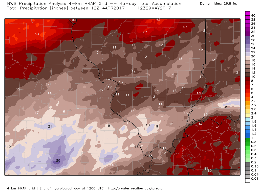
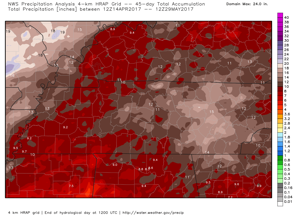
Let’s look at a few precipitation maps.
Look at how much rain has fallen over the last 45 days. North and south view.
Crazy rain totals!
Click images for a larger view.
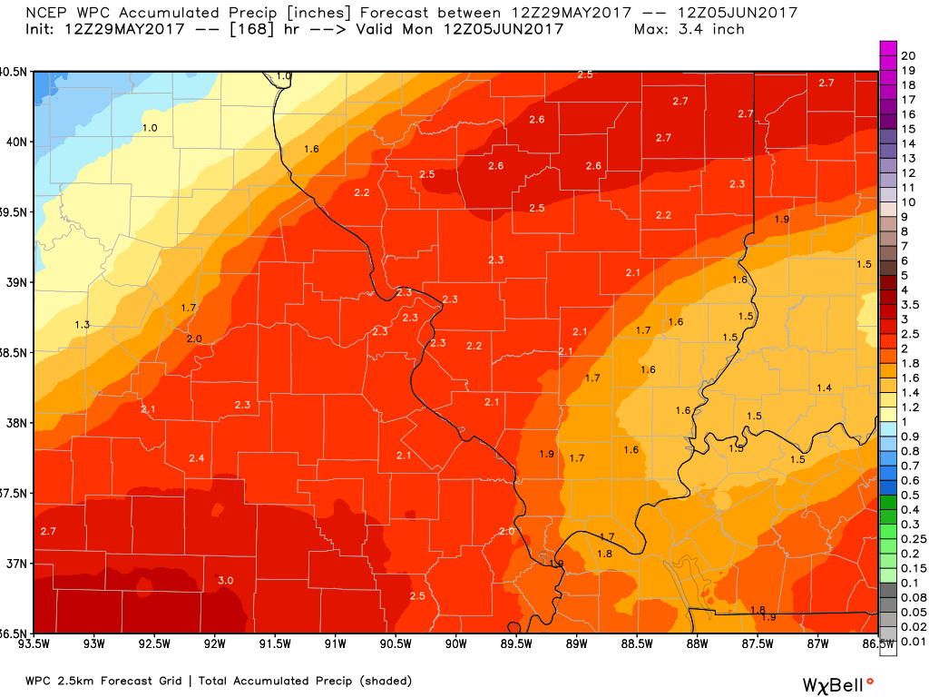
Now, let’s look ahead of forecast rain totals.
North view
This is the seven day rainfall forecast.
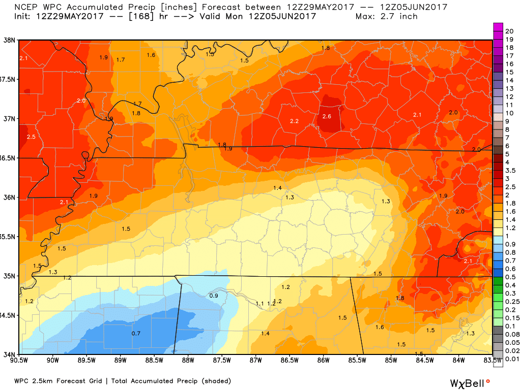
South view
Seven day rain forecast.
Let me break that down in 24 hour periods. This is the GFS model’s idea of what might fall.
Keep in mind, these models change quite frequently. Exact rainfall totals are uncertain this far out. With that said, I wanted to give you some idea of which days might produce a bit more rain.
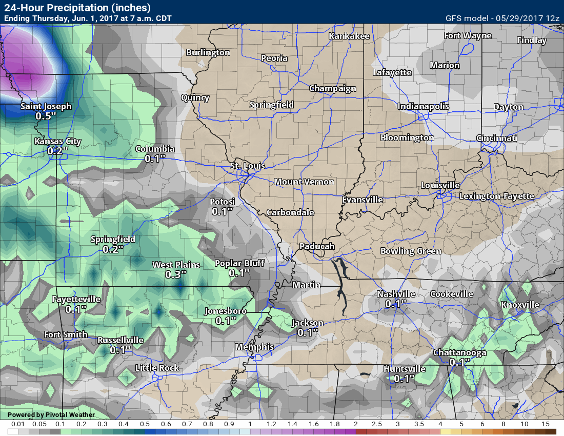
This is 7 am Wednesday to 7 am on Thursday
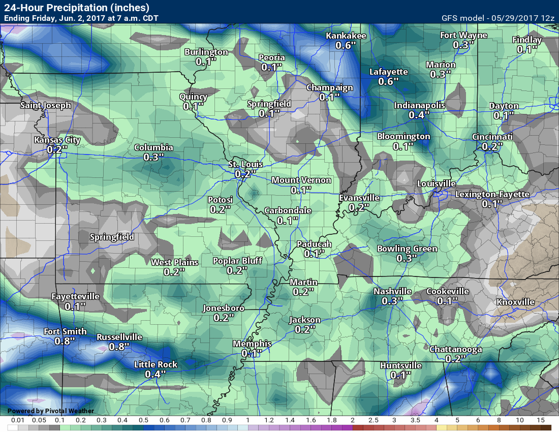
This next image is 7 am Thursday through 7 am Friday
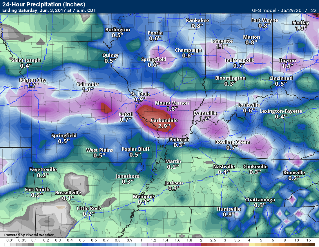
This next image is 7 am Friday through 7 am Saturday
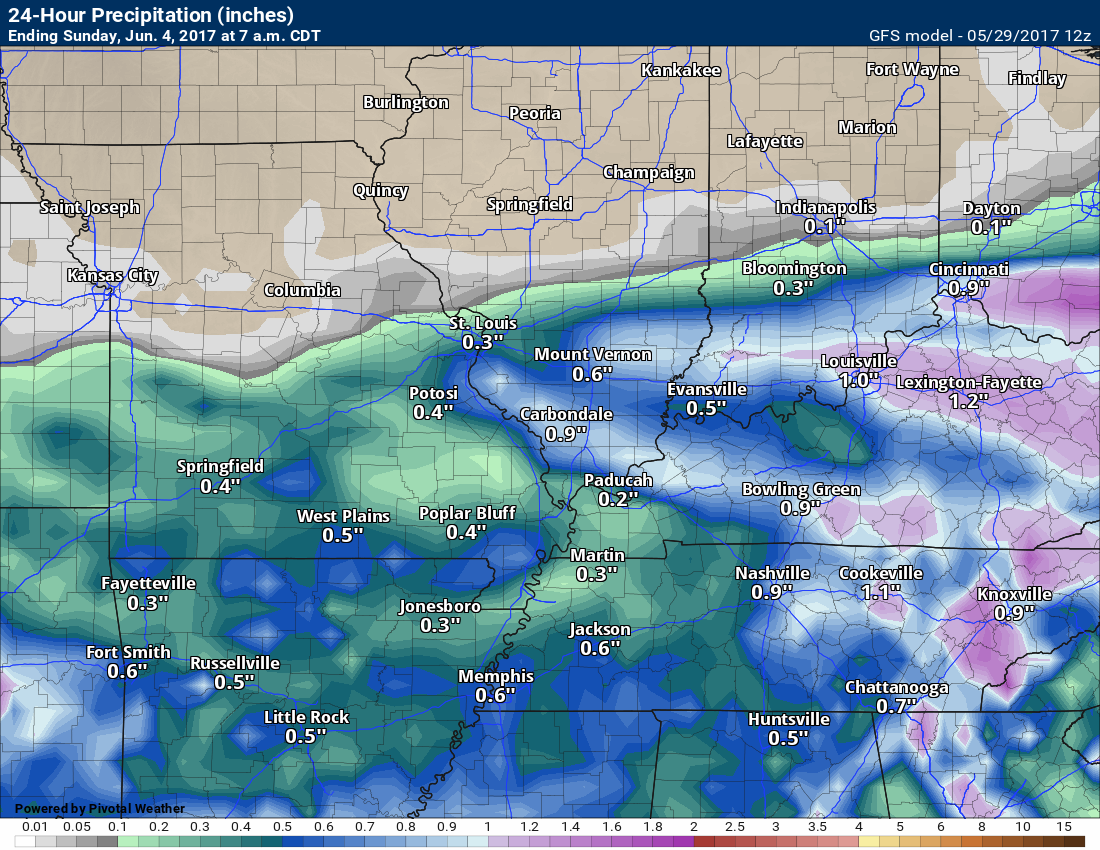
This next image is 7 am Saturday through 7 am Sunday
Typically June and July are the months that we worry about flash flooding. Slow moving thunderstorms can drop three to five inches of rain in isolated spots. We seem to have this every year. The question is always, where?
Something to monitor as we move forward into the Month of June.
The June precipitation outlook is for above normal precipitation.

Find me on Twitter
.

We have regional radars and local city radars – if a radar does not update then try another one. Occasional browsers need their cache cleared. You may also try restarting your browser. That usually fixes the problem. Occasionally we do have a radar go down. That is why I have duplicates. Thus, if one fails then try another one.
During the winter you can track snow and ice by clicking the winterize button on the local city view interactive radars.
If you have any problems then please send me an email beaudodson@usawx.com
Interactive Weather Radar Page. Choose the city nearest your location: Click this link—
National interactive radar: Click this link.
Local interactive city radars include St Louis, Mt Vernon, Evansville, Poplar Bluff, Cape Girardeau, Marion, Paducah, Hopkinsville, Memphis, Nashville, Dyersburg, and all of eastern Kentucky. These are interactive radars. Local city radars – click here
.

The official 6-10 day and 8-14 day temperature and precipitation outlook. Check the date stamp at the top of each image (so you understand the time frame).
.
The forecast maps below are issued by the Weather Prediction Center (NOAA)
.

.

.
The latest 8-14 day temperature and precipitation outlook. Note the dates are at the top of the image. These maps DO NOT tell you how high or low temperatures or precipitation will be. They simply give you the probability as to whether temperatures or precipitation will be above or below normal.
.


.
The Beau Dodson Weather APP is ready for Apple and Android users. The purpose of this app is for me to deliver your text messages instantly. ATT and Verizon have not always been reliable when it comes to speed. The app allows instant delivery.
Some of you have asked if you can keep receiving the texts on your phone and the app. The answer to that is, yes. The Android app will automatically allow that to happen. On the Apple app, however, you will need to go into your app and click settings. Make sure the green tab is OFF. Off means you will still receive the texts to your phone and the app. If you have any questions, then email me at beaudodson@usawx.com
The app is for text subscribers.
The direct download, for the Apple app, can be viewed here
https://itunes.apple.com/us/app/id1190136514
If you have not signed up for the texting service then you may do so at www.beaudodsonweather.com

The Android app is also ready.
Remember, the app’s are for www.weathertalk.com subscribers. The app allows your to receive the text messages faster than ATT and Verizon.
Here is the download link for the Android version Click Here

——————————————————–
If you have not signed up for the texts messages, then please do. Link www.beaudodsonweather.com
Your support helps with the following:

and


Who do you trust for your weather information and who holds them accountable?
I have studied weather in our region since the late 1970’s. I have 39 years of experience in observing our regions weather patterns. My degree is in Broadcast Meteorology and a Bachelor’s of Science.
My resume includes:
Member of the American Meteorological Society.
NOAA Weather-Ready Nation Ambassador.
Meteorologist for McCracken County Emergency Management. I served from 2005 through 2015.
Meteorologist for McCracken County Rescue. 2015 through current
I own and operate the Southern Illinois Weather Observatory.
I am the chief meteorologist for Weather Talk LLC. I am the owner of Weather Talk LLC.
I am also a business owner in western Kentucky.
Recipient of the Mark Trail Award, WPSD Six Who Make A Difference Award, Kentucky Colonel, and the Caesar J. Fiamma” Award from the American Red Cross.
In 2005 I helped open the largest American Cross shelter in U.S. history in Houston, Texas. I was deployed to help after Hurricane Katrina and Hurricane Rita. I was a shelter manager of one of the Houston, Texas shelter divisions.
In 2009 I was presented with the Kentucky Office of Highway Safety Award.
Recognized by the Kentucky House of Representatives for my service to the State of Kentucky leading up to several winter storms and severe weather outbreaks.
If you click on the image below you can read the Kentucky House of Representatives Resolution.

I am also President of the Shadow Angel Foundation which serves portions of western Kentucky and southern Illinois.
There is a lot of noise on the internet. A lot of weather maps are posted without explanation. Over time you should learn who to trust for your weather information.
My forecast philosophy is simple and straight forward.
- Communicate in simple terms
- To be as accurate as possible within a reasonable time frame before an event
- Interact with you on Twitter, Facebook, email, texts, and this blog
- Minimize the “hype” that you might see on some television stations or through other weather sources
- Push you towards utilizing wall-to-wall LOCAL TV coverage during severe weather events
Many of the graphics on this page are from www.weatherbell.com
WeatherBell is a great resource for weather model guidance.


You can sign up for my AWARE email by clicking here I typically send out AWARE emails before severe weather, winter storms, or other active weather situations. I do not email watches or warnings. The emails are a basic “heads up” concerning incoming weather conditions