Friday Morning Severe Weather Update.
Saturday’s severe weather threat covers the entire area.
Don’t forget the texting service takes priority over everything else that I do. I am sure there will be a lot of texts sent out over the coming days. You can sign up at www.beaudodsonweather.com
Remember, you have not signed up until you have entered your phone number and counties.
Subscribers:
I will text you the links to the latest Facebook updates, blog, and video updates. Make sure you have text option TWO turned on. That is the social media option for severe weather days.
The tornado text would be Weather One. That is the first text option. Make sure that is always on.
Today:
Thunderstorms formed over eastern Kansas overnight. They have spread into parts of southeast Missouri. These storms should die out over the coming hours.
These storms will leave outflow boundaries (boundaries where storms died). Later today, there is the possibility that a few storms could redevelop. If they were to redevelop, then they could produce a few reports of nickel size hail and gusty winds. Lightning, of course.
Tonight: Guidance is all over the place with tonight’s forecast.
A disturbance passes to our north and east overnight. A few storms could develop to our north and move south/southeast. If this happens then there will be a chance for storms entering southern Illinois and western Kentucky after 1 a.m. Low confidence that storms form tonight.
There is a 20% chance of a severe thunderstorm watch to be issued for portions of our area tonight.
Saturday:
Medium to high confidence in the forecast.
Severe weather likely Saturday afternoon and night.
The atmosphere is forecast to become unstable on Saturday afternoon and night. CAPE values of 3000 to 5000, lift index values of -8 to -12, bulk wind shear greater than 40 knots, and a weakening cap. All of those parameters spell trouble.
Currently, it appears that a line of thunderstorms will develop over Missouri on Saturday afternoon.
The storms would then race east/southeast at 60 to 70 mph. The line could bow.
Supercells could also form ahead of the line. Low confidence on supercells developing.
Storms on Saturday afternoon and night could produce golf ball size hail or larger, 70 mph winds or higher, and even a few tornadoes.
I would advise everyone to have multiple ways of receiving their severe weather information.
There is a 70% chance of a severe thunderstorm and/or tornado watch being issued for the region on Saturday afternoon and night.
Sunday:
The cold front might remain to our west on Sunday morning. If that happens then more storms could redevelop and become severe.
Large hail and damaging winds would be the primary concern. Isolated tornado risk on Sunday, as well.
There is a 50% chance of a severe thunderstorm or tornado watch being issued for portions of the region on Sunday.
Sunday night and Monday: Thunderstorm chances will come to an end. Dry conditions are forecast for Memorial Day. Temperatures in the 70’s to perhaps 80 degrees.

.

This forecast update covers far southern Illinois, far southeast Missouri, and far western Kentucky. See the coverage map on the right side of the blog.
May 25, 2017
Thursday Night Forecast Details:
Forecast: Mostly clear. Breezy, at times. A few passing clouds.
Temperatures: MO ~ 54 to 58 IL ~ 54 to 58 KY ~ 55 to 60 TN ~ 55 to 60
Winds: South and southwest winds at 8 to 16 mph. Winds may become southeast and south late. Gusty winds possible overnight.
My confidence in the forecast verifying: High. This forecast should verify.
What impacts are anticipated from the weather? None.
Is severe weather expected? No
The NWS defines severe weather as 58 mph winds or great, 1″ hail or larger, and/or tornadoes
What is the chance of precipitation? MO ~ 0% IL ~ 0% KY ~ 0% TN ~ 0%
Coverage of precipitation: None anticipated.
Should I cancel my outdoor plans? No
.
May 26, 2017
Friday Forecast Details
Forecast: Partly sunny. Periods of passing clouds. Warmer. More humid. Windy, at times. A 20% to 30% chance for a shower or thunderstorm.
Temperatures: MO ~ 80 to 84 IL 80 to 84 KY 80 to 84 TN 80 to 84
Winds: South and southwest wind at 10 to 20 mph.
What impacts are anticipated from the weather? Wet roadways. Lightning.
My confidence in the forecast verifying: Medium. Some adjustments are possible.
Is severe weather expected? Unlikely. If a thunderstorm were to form it could be intense, but it is questionable if storms will form.
The NWS defines severe weather as 58 mph winds or great, 1″ hail or larger, and/or tornadoes
What is the chance of precipitation? MO ~ 30% IL ~ 30% KY ~ 20% TN ~ 20%
Coverage of precipitation: Isolated.
Should I cancel my outdoor plans? No, but monitor radars.
.
Friday Night Forecast Details:
Forecast: Partly cloudy. A chance for showers and thunderstorms. The risk for storms on Friday night is a bit uncertain. Perhaps the greatest risk for storms will be over the northern parts of southeast Missouri, northern parts of southern Illinois, southeast Illinois, into parts of western Kentucky.
Temperatures: MO ~ 65 to 70 IL ~ 65 to 70 KY ~ 65 to 70 TN ~ 65 to 70
Winds: Southwest at 10 mph with gusts to 20 mph.
My confidence in the forecast verifying: Medium. Some adjustments are possible.
What impacts are anticipated from the weather? Locally heavy downpours and lightning. I will be monitoring the risk for a few intense thunderstorms with hail and high winds (northern counties).
Is severe weather expected? Monitor updates. I can’t rule out a few strong thunderstorms. Monitor updates.
The NWS defines severe weather as 58 mph winds or great, 1″ hail or larger, and/or tornadoes
What is the chance of precipitation? MO ~ 30% IL ~ 30% KY ~ 30% TN ~ 20% (these numbers may need adjusting)
Coverage of precipitation: Perhaps scattered.
Should I cancel my outdoor plans? No, but I would monitor updated forecasts.
.
May 27, 2017
Saturday Forecast Details
Forecast: Partly cloudy. Warm. Muggy. A chance for a few morning showers and storms. Thunderstorms becoming more likely late Saturday afternoon and evening. Some storms could become severe with large hail and damaging winds. Heat index values above 90 degrees.
Temperatures: MO ~ 86 to 88 IL 86 to 88 KY 85 to 90 TN 85 to 90
Winds: South and southwest wind at 6 to 12 mph with gusts to 25 mph.
What impacts are anticipated from the weather? Wet roadways. Lightning. A few storms could produce hail and high winds.
My confidence in the forecast verifying: Medium. Some adjustments are possible.
Is severe weather expected? Yes. There is a risk for severe thunderstorms.
The NWS defines severe weather as 58 mph winds or great, 1″ hail or larger, and/or tornadoes
What is the chance of precipitation? MO ~ 30% morning and 50% afternoon IL ~ 30% morning and 50% KY ~ 20% morning and 40% afternoon TN ~ 20% morning and 30% afternoon
Coverage of precipitation: Scattered to numerous. Most of the storms will probably occur late Saturday afternoon from west to east in the region. That means southeast Missouri will have a better chance for storms during the afternoon than say western Kentucky. Storms will spread east with time. A few storms could form ahead of the main thunderstorm line, as well.
Should I cancel my outdoor plans? Monitor updates and have a severe weather safety plan.
.
Saturday Night Forecast Details:
Forecast: Becoming cloudy. Warm and muggy during the evening hours. Showers and thunderstorms developing. Some storms could become severe with large hail and damaging winds.
Temperatures: MO ~ 65 to 70 IL ~ 65 to 70 KY ~ 65 to 70 TN ~ 65 to 70
Winds: Southwest at 8 to 16 mph. Winds may shift out of the west and northwest late.
My confidence in the forecast verifying: Medium. Some adjustments are possible.
What impacts are anticipated from the weather? Wet roadways. Lightning. Damaging winds. Hail.
Is severe weather expected? Yes. Some thunderstorms could become severe.
The NWS defines severe weather as 58 mph winds or great, 1″ hail or larger, and/or tornadoes
What is the chance of precipitation? MO ~ 60% IL ~ 60% KY ~ 60% TN ~ 60%
Coverage of precipitation: Numerous.
Should I cancel my outdoor plans? Monitor updates. Have a severe weather safety plan.
.
May 28, 2017
Sunday Forecast Details
Forecast: Partly to mostly cloudy. A 50% chance of morning showers and thunderstorms. A 30% for afternoon showers and thunderstorms.
Temperatures: MO ~ 76 to 82 IL 76 to 82 KY 76 to 82 TN 76 to 82
Winds: West winds at 5 to 10 mph.
What impacts are anticipated from the weather? Wet roadways. Lightning.
My confidence in the forecast verifying: Medium. Some adjustments are possible.
Is severe weather expected? Monitor updates early Sunday morning.
The NWS defines severe weather as 58 mph winds or great, 1″ hail or larger, and/or tornadoes
What is the chance of precipitation? MO ~ 50% IL ~ 50% KY ~ 50% TN ~ 50%
Coverage of precipitation: Numerous before 7 am and then scattered.
Should I cancel my outdoor plans? No.
.
Sunday Night Forecast Details:
Forecast: Partly cloudy. Isolated showers and thunderstorms early. Low confidence on any rain remaining in the area.
Temperatures: MO ~ 56 to 62 IL ~ 56 to 62 KY ~ 56 to 62 TN ~ 56 to 62
Winds: Northwest winds at 4 to 8 mph.
My confidence in the forecast verifying: Low. Significant adjustments are possible.
What impacts are anticipated from the weather? Patchy fog. Perhaps some wet roadways.
Is severe weather expected? No
The NWS defines severe weather as 58 mph winds or great, 1″ hail or larger, and/or tornadoes
What is the chance of precipitation? MO ~ 20% IL ~ 20% KY ~ 20% TN ~ 20%
Coverage of precipitation: None to isolated.
Should I cancel my outdoor plans? No, but perhaps check radars early in the evening.
.
May 29, 2017
Monday Forecast Details
Forecast: Perhaps some morning patchy fog. Mostly sunny. A few passing clouds. A pleasant day anticipated.
Temperatures: MO ~ 76 to 82 IL 76 to 82 KY 76 to 82 TN 78 to 82
Winds: West winds at 5 to 10 mph.
What impacts are anticipated from the weather? None.
My confidence in the forecast verifying: Medium. Some adjustments are possible.
Is severe weather expected? No.
The NWS defines severe weather as 58 mph winds or great, 1″ hail or larger, and/or tornadoes
What is the chance of precipitation? MO ~ 0% IL ~ 0% KY ~ 0% TN ~ 0%
Coverage of precipitation: None
Should I cancel my outdoor plans? No
.
Monday Night Forecast Details:
Forecast: Mostly clear. A few passing clouds.
Temperatures: MO ~ 55 to 60 IL ~ 55 to 60 KY ~ 55 to 60 TN ~ 55 to 60
Winds: West and northwest winds at 5 mph.
My confidence in the forecast verifying: Medium. Some adjustments are possible.
What impacts are anticipated from the weather? None
Is severe weather expected? No
The NWS defines severe weather as 58 mph winds or great, 1″ hail or larger, and/or tornadoes
What is the chance of precipitation? MO ~ 0% IL ~ 0% KY ~ 0% TN ~ 0%
Coverage of precipitation: None anticipated.
Should I cancel my outdoor plans? No
.
May 30, 2017
Tuesday Forecast Details
Forecast: Partly sunny. A slight chance of showers and thunderstorms over southeast Missouri.
Temperatures: MO ~ 75 to 80 IL 75 to 80 KY 78 to 84 TN 78 to 82
Winds: West winds at 5 to 10 mph.
What impacts are anticipated from the weather? Wet roadways and lightning. This would mainly be over southeast Missouri.
My confidence in the forecast verifying: Medium. Some adjustments are possible.
Is severe weather expected? No.
The NWS defines severe weather as 58 mph winds or great, 1″ hail or larger, and/or tornadoes
What is the chance of precipitation? MO ~ 20% IL ~ 20% KY ~ 10% TN ~ 10%
Coverage of precipitation: Isolated.
Should I cancel my outdoor plans? No
.
Tuesday Night Forecast Details:
Forecast: Partly cloudy. A slight chance of a shower or thunderstorm.
Temperatures: MO ~ 55 to 60 IL ~ 55 to 60 KY ~ 55 to 60 TN ~ 55 to 60
Winds: West and northwest winds at 5 mph.
My confidence in the forecast verifying: Medium. Some adjustments are possible.
What impacts are anticipated from the weather? Wet roadways. Lightning.
Is severe weather expected? No
The NWS defines severe weather as 58 mph winds or great, 1″ hail or larger, and/or tornadoes
What is the chance of precipitation? MO ~ 20% IL ~ 20% KY ~ 20% TN ~ 20%
Coverage of precipitation: Scattered.
Should I cancel my outdoor plans? No
.
Don’t forget to check out the Southern Illinois Weather Observatory web-site for weather maps, tower cams, scanner feeds, radars, and much more! Click here
..

A severe thunderstorm is defined as a storm that produces quarter size hail or larger, 58 mph winds or greater, and/or a tornado. That is the official National Weather Service definition of a severe thunderstorm.
Thursday night: Severe weather is not anticipated.
Friday and Friday night: A few thunderstorms are possible, especially on Friday night. I will be monitoring a potential MCS late Friday night. An MCS is a large complex of thunderstorms. This would perhaps impact the northern portions of our local area. That would include areas from Perry County, Missouri towards Evansville, Indiana. Confidence is low.
Saturday into Saturday night: A severe weather event is possible late Saturday afternoon and Saturday night. Large hail, damaging winds, and tornadoes can’t be ruled out. Monitor updates.
Sunday into Monday: Storms should come to an end on Sunday morning. A couple of thunderstorms may remain in the area late Sunday morning and afternoon. Severe weather is not anticipated om Monday.

Weather Analysis for the coming week:
Interactive Weather Radar Page. Choose the city nearest your location: Click this link—
Thursday night into Friday night:
Warm conditions with some passing clouds can be expected for both Thursday night and Friday. Rain chances will be limited. Warm air aloft will keep the atmosphere capped. I can’t rule out a few showers or thunderstorms, but widespread precipitation appears unlikely.
There will be a few more clouds on Friday night. I can’t rule out some late night thunderstorms over our northern counties of southeast Missouri and southern Illinois. Confidence on this happening is rather low. It is possible an MCS will form well to our northwest and track southeast.
The system would likely move east and southeast. It is possible this system could impact our northern counties. Severe weather can’t be ruled out. Monitor updates.
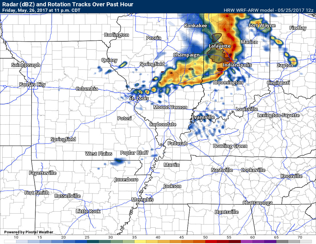
Here is the future-cast radar from one of the high resolution models. This is HRW-WRF ARW model.
This is for 11 PM on Friday night. This band of storms would then spread south and east. Again, low confidence on the outcome of the Friday night system.
Saturday and Saturday night:
Severe Thunderstorms Possible Late Saturday into Saturday Night
If you have outdoor plans this weekend, then monitor the latest forecasts. Severe storms are possible, if not likely on Saturday afternoon and night.
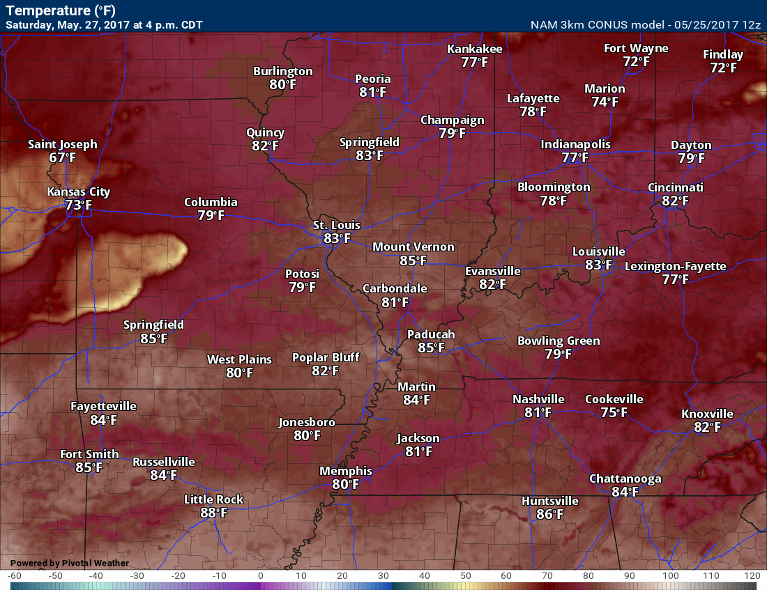
Temperatures will rise into the 80’s on Saturday with dew points in the 70’s. It will feel muggy. A few spots could touch 90 degrees.
A cold front will enter the region on Saturday night. This front will become the focus for thunderstorm development. Some of the storms could become severe with hail and high winds. I can’t rule out tornadoes. I would suggest everyone monitor for possible watches and warnings. There is still some time for adjustments in the forecast, but right now it does appear severe storms are likely somewhere in our local region.
Instability will be sufficient for severe thunderstorms. PWAT values will be high. That means there will be a lot of moisture in the atmosphere. Lift index values should drop below -8. CAPE values of 2000 and above. Wind shear will be strong enough to warrant our attention.
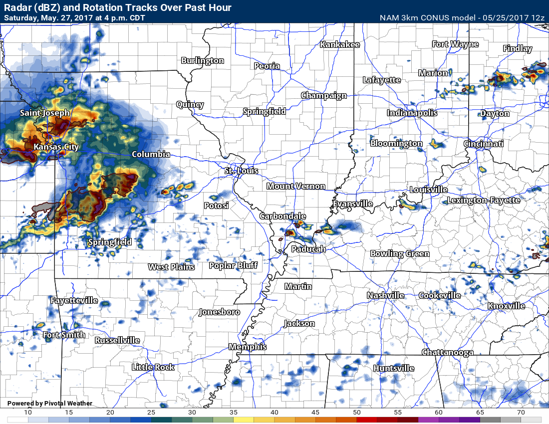
Future-cast radar for 4 pm Saturday. LONG way off for the models to nail the details. This is what the NAM believes will occur.
4 PM
and 7 pm

7 PM
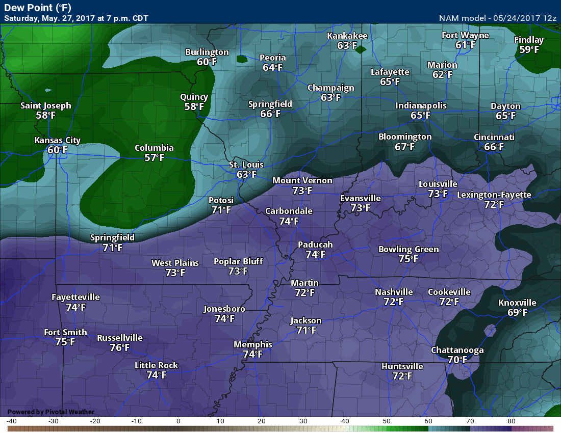
Dew point map
These are oppressive numbers. It will feel muggy on Saturday. Summer air.
High temperatures on Saturday
and PWAT map
This is a measure of moisture in the entire atmosphere. Top to bottom.

These ingredients point towards the risk for some strong to severe thunderstorms.
We will have to monitor the cap on Saturday, as well. A cap can keep thunderstorms from forming. This allows energy to build during the day. This can lead to explosive thunderstorm development once storms break the cap.
It appears there might be a cap during a portion of the day, but the cap will erode and likely break during the afternoon/evening hours.
Understanding the cap.

Another graphic explaining the cap.

Here are some of those ingredients.
Click the images for a larger view
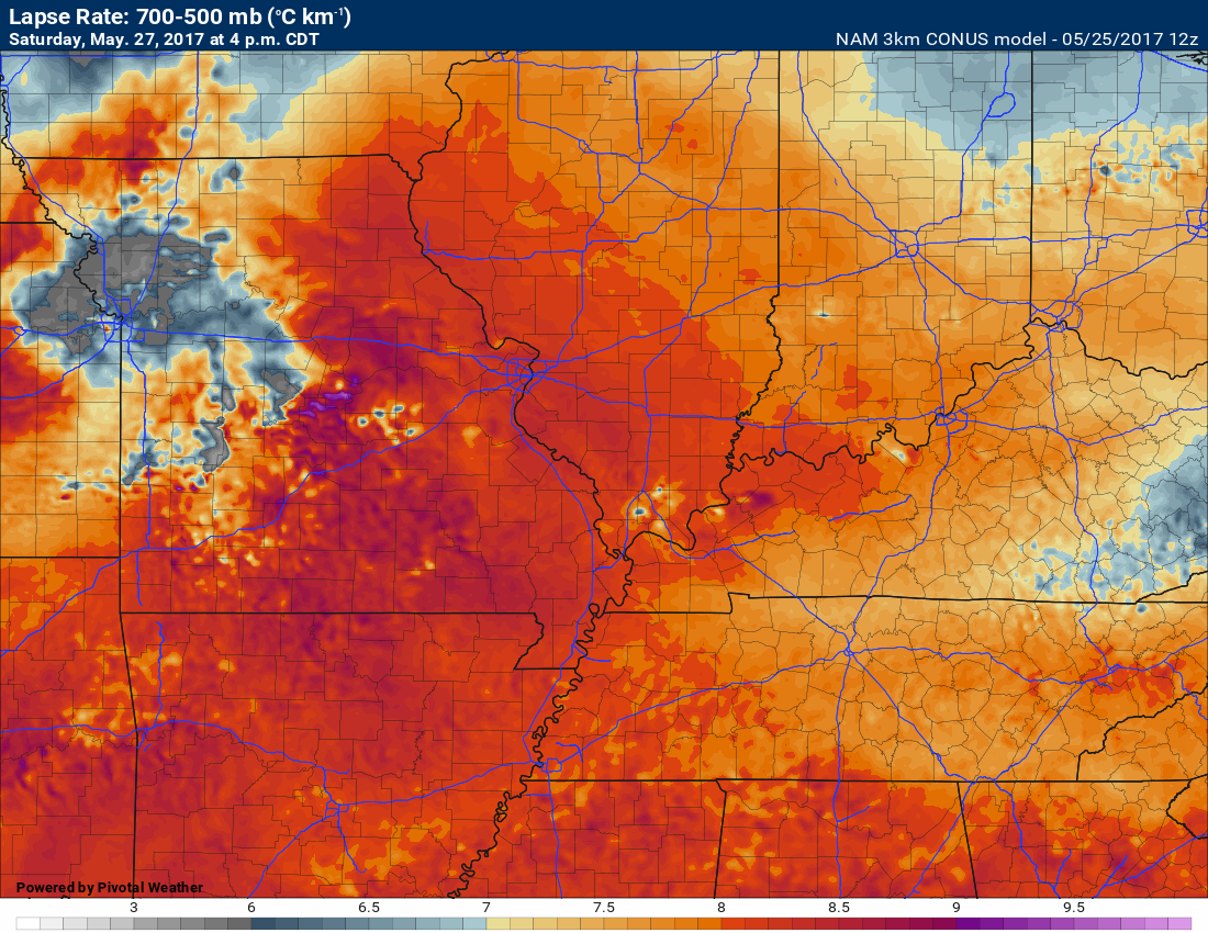
Lapse rates. Higher lapse rates are an indicator of hail potential and updraft potential. These are some fairly high numbers. If storms can form then they should not have any problem rapidly becoming strong.
This next image is for surface based CAPE. Higher CAPE numbers equal more energy for thunderstorms to tap into.
NAM shows 4000+ CAPE numbers. Those are high numbers (if they verify).

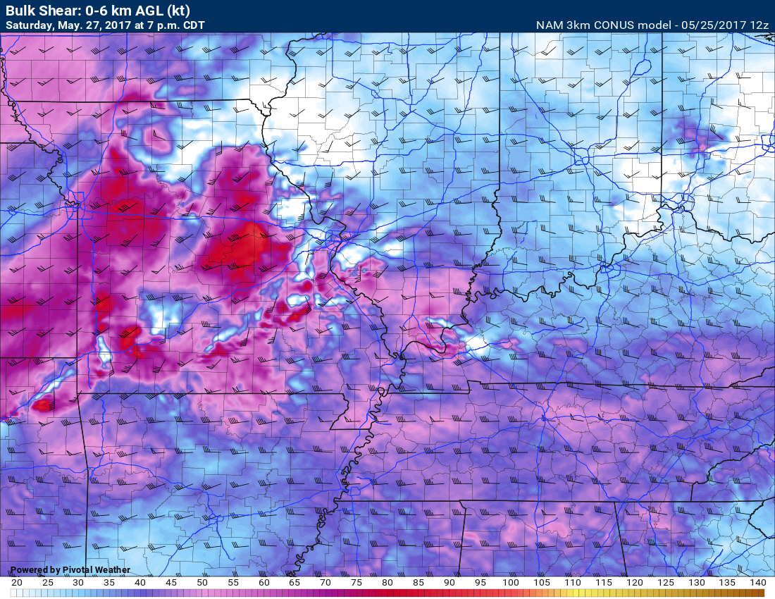
This next image is the bulk shear numbers. Wind shear. Wind shear is one ingredient for thunderstorm development.
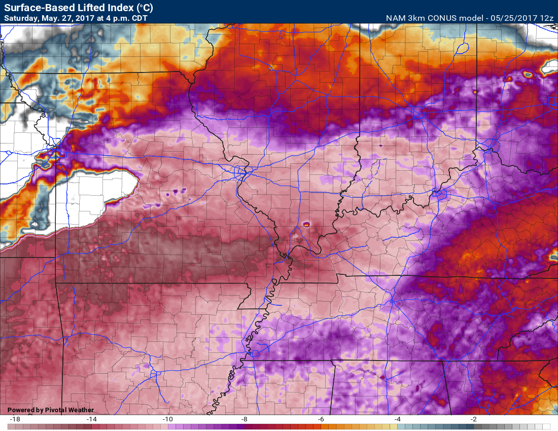
This next image is the lifted index values. Another severe weather model parameter. These are large numbers.
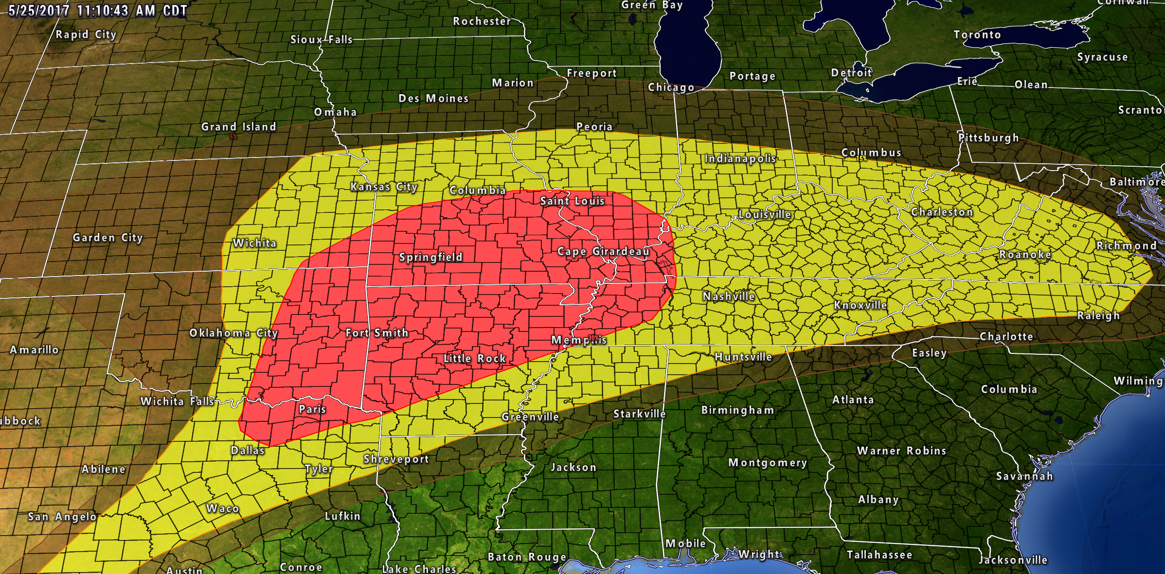
The Storm Prediction Center already has a portion of the region outlined for a severe weather risk on Saturday. I am sure this will need adjusting. Monitor updates.
A few showers and thunderstorms are possible into Sunday afternoon, but activity should be on the way out. It is possible that most of Sunday will remain dry (after 10 am). This part of the forecast will be highly dependent on how fast the cold front exits the local area. Hoping for the best.
Dry weather is forecast for Monday. Temperatures mostly in the 75 to 80-degree range. It should be a nice day for outdoor events.

Find me on Twitter
.

We have regional radars and local city radars – if a radar does not update then try another one. Occasional browsers need their cache cleared. You may also try restarting your browser. That usually fixes the problem. Occasionally we do have a radar go down. That is why I have duplicates. Thus, if one fails then try another one.
During the winter you can track snow and ice by clicking the winterize button on the local city view interactive radars.
If you have any problems then please send me an email beaudodson@usawx.com
Interactive Weather Radar Page. Choose the city nearest your location: Click this link—
National interactive radar: Click this link.
Local interactive city radars include St Louis, Mt Vernon, Evansville, Poplar Bluff, Cape Girardeau, Marion, Paducah, Hopkinsville, Memphis, Nashville, Dyersburg, and all of eastern Kentucky. These are interactive radars. Local city radars – click here
.

The official 6-10 day and 8-14 day temperature and precipitation outlook. Check the date stamp at the top of each image (so you understand the time frame).
.
The forecast maps below are issued by the Weather Prediction Center (NOAA)
.

.

.
The latest 8-14 day temperature and precipitation outlook. Note the dates are at the top of the image. These maps DO NOT tell you how high or low temperatures or precipitation will be. They simply give you the probability as to whether temperatures or precipitation will be above or below normal.
.


.
The Beau Dodson Weather APP is ready for Apple and Android users. The purpose of this app is for me to deliver your text messages instantly. ATT and Verizon have not always been reliable when it comes to speed. The app allows instant delivery.
Some of you have asked if you can keep receiving the texts on your phone and the app. The answer to that is, yes. The Android app will automatically allow that to happen. On the Apple app, however, you will need to go into your app and click settings. Make sure the green tab is OFF. Off means you will still receive the texts to your phone and the app. If you have any questions, then email me at beaudodson@usawx.com
The app is for text subscribers.
The direct download, for the Apple app, can be viewed here
https://itunes.apple.com/us/app/id1190136514
If you have not signed up for the texting service then you may do so at www.beaudodsonweather.com

The Android app is also ready.
Remember, the app’s are for www.weathertalk.com subscribers. The app allows your to receive the text messages faster than ATT and Verizon.
Here is the download link for the Android version Click Here

——————————————————–
If you have not signed up for the texts messages, then please do. Link www.beaudodsonweather.com
Your support helps with the following:

and


Who do you trust for your weather information and who holds them accountable?
I have studied weather in our region since the late 1970’s. I have 39 years of experience in observing our regions weather patterns. My degree is in Broadcast Meteorology and a Bachelor’s of Science.
My resume includes:
Member of the American Meteorological Society.
NOAA Weather-Ready Nation Ambassador.
Meteorologist for McCracken County Emergency Management. I served from 2005 through 2015.
Meteorologist for McCracken County Rescue. 2015 through current
I own and operate the Southern Illinois Weather Observatory.
I am the chief meteorologist for Weather Talk LLC. I am the owner of Weather Talk LLC.
I am also a business owner in western Kentucky.
Recipient of the Mark Trail Award, WPSD Six Who Make A Difference Award, Kentucky Colonel, and the Caesar J. Fiamma” Award from the American Red Cross.
In 2005 I helped open the largest American Cross shelter in U.S. history in Houston, Texas. I was deployed to help after Hurricane Katrina and Hurricane Rita. I was a shelter manager of one of the Houston, Texas shelter divisions.
In 2009 I was presented with the Kentucky Office of Highway Safety Award.
Recognized by the Kentucky House of Representatives for my service to the State of Kentucky leading up to several winter storms and severe weather outbreaks.
If you click on the image below you can read the Kentucky House of Representatives Resolution.

I am also President of the Shadow Angel Foundation which serves portions of western Kentucky and southern Illinois.
There is a lot of noise on the internet. A lot of weather maps are posted without explanation. Over time you should learn who to trust for your weather information.
My forecast philosophy is simple and straight forward.
- Communicate in simple terms
- To be as accurate as possible within a reasonable time frame before an event
- Interact with you on Twitter, Facebook, email, texts, and this blog
- Minimize the “hype” that you might see on some television stations or through other weather sources
- Push you towards utilizing wall-to-wall LOCAL TV coverage during severe weather events
Many of the graphics on this page are from www.weatherbell.com
WeatherBell is a great resource for weather model guidance.


You can sign up for my AWARE email by clicking here I typically send out AWARE emails before severe weather, winter storms, or other active weather situations. I do not email watches or warnings. The emails are a basic “heads up” concerning incoming weather conditions