
.

This forecast update covers far southern Illinois, far southeast Missouri, and far western Kentucky. See the coverage map on the right side of the blog.
May 23, 2017
Tuesday Night Forecast Details:
Forecast: Cloudy. Showers possible. A rumble of thunder possible. Rainfall totals mostly less than 0.20″.
Temperatures: MO ~ 50 to 55 IL ~ 52 to 56 KY ~ 52 to 56 TN ~ 52 to 56
Winds: Winds becoming west and northwest 5 to 10 mph with gusts to 15 mph.
My confidence in the forecast verifying: High. This forecast should verify.
What impacts are anticipated from the weather? Wet roadways. I can’t rule out lightning.
Is severe weather expected? No.
The NWS defines severe weather as 58 mph winds or great, 1″ hail or larger, and/or tornadoes
What is the chance of precipitation? MO ~ 60% IL ~ 60% KY ~ 70% TN ~ 70%
Coverage of precipitation: Scattered to perhaps numerous at times.
Should I cancel my outdoor plans? No, but monitor radars for rain showers.
.
May 24, 2017
Wednesday Forecast Details
Forecast: Quite a few clouds. A few morning showers possible over southeast Missouri and southwest Illinois. Rain likely over southeast Illinois, western Kentucky, and western Tennessee (esp during the morning hours). A few scattered showers and thunderstorms during the afternoon. Thunderstorms could produce small hail.
Temperatures: MO ~ 64 to 68 IL 64 to 68 KY 64 to 68 TN 64 to 68
Winds: Northwest at 10 mph with gusts to 14 mph.
What impacts are anticipated from the weather? Wet roadways. Perhaps lightning. A few reports of small hail possible. Cold air funnels.
My confidence in the forecast verifying: Medium. Some adjustments are possible.
Is severe weather expected? No
The NWS defines severe weather as 58 mph winds or great, 1″ hail or larger, and/or tornadoes
What is the chance of precipitation? MO ~ 50% IL ~ 60% KY ~ 60% TN ~ 60%
Coverage of precipitation: Numerous before 10 am and then becoming scattered.
Should I cancel my outdoor plans? Some rain is possible. Have a plan B, just in case.
.
Wednesday Night Forecast Details:
Forecast: Partly cloudy. Gusty winds developing. A few evening showers or thunderstorms ending. A remaining chance for a few showers over southeast Illinois, northwest Kentucky, and the Pennyrile area of western Kentucky. Otherwise, a few clouds and patchy fog late. Cool temperatures for the region.
Temperatures: MO ~ 50 to 55 IL ~ 50 to 55 KY ~ 54 to 56 TN ~ 54 to 58
Winds: Northwest becoming west at 10 mph with gusts to 20 mph. Some higher gusts not out of the question.
My confidence in the forecast verifying: High. this forecast should verify.
What impacts are anticipated from the weather? Wet roadways.
Is severe weather expected? No
The NWS defines severe weather as 58 mph winds or great, 1″ hail or larger, and/or tornadoes
What is the chance of precipitation? MO ~ 30% IL ~ 30% KY ~ 40% TN ~ 30%
Coverage of precipitation: Widely scattered
Should I cancel my outdoor plans? No.
.
May 25, 2017
Thursday Forecast Details
Forecast: Morning clouds over southeast Illinois and portions of western Kentucky. Otherwise, partly cloudy. A slight chance of showers. A Pleasant day, overall (once clouds exit).
Temperatures: MO ~ 70 to 74 IL 70 to 74 KY 70 to 75 TN 72 to 76
Winds: Morning winds of west and northwest at 7 to 14 mph. Afternoon winds from the west and northwest at 5 to 10 mph with gusts to 15 mph.
What impacts are anticipated from the weather? Most likely none.
My confidence in the forecast verifying: High. This forecast should verify.
Is severe weather expected? No
The NWS defines severe weather as 58 mph winds or great, 1″ hail or larger, and/or tornadoes
What is the chance of precipitation? MO ~ 10% IL ~ 10% KY ~ 10% TN ~ 10%
Coverage of precipitation: Most likely none.
Should I cancel my outdoor plans? No
.
Thursday Night Forecast Details:
Forecast: Mostly clear. A few passing clouds. Patchy fog possible.
Temperatures: MO ~ 54 to 58 IL ~ 54 to 58 KY ~ 55 to 60 TN ~ 55 to 60
Winds: South and southwest winds at 5 mph.
My confidence in the forecast verifying: High. This forecast should verify.
What impacts are anticipated from the weather? Patchy fog might reduce visibilities in a few locations.
Is severe weather expected? No
The NWS defines severe weather as 58 mph winds or great, 1″ hail or larger, and/or tornadoes
What is the chance of precipitation? MO ~ 10% IL ~ 10% KY ~ 10% TN ~ 10%
Coverage of precipitation: Most likely none.
Should I cancel my outdoor plans? No
.
May 26, 2017
Friday Forecast Details
Forecast: Partly sunny. Periods of passing clouds. Warmer. More humid. Windy, at times. A 20% to 30% chance for a shower or thunderstorm.
Temperatures: MO ~ 80 to 84 IL 80 to 84 KY 80 to 84 TN 80 to 84
Winds: South and southwest wind at 10 to 20 mph with higher gusts likely.
What impacts are anticipated from the weather? Wet roadways. Lightning.
My confidence in the forecast verifying: Medium. Some adjustments are possible.
Is severe weather expected? Unlikely, but monitor updates.
The NWS defines severe weather as 58 mph winds or great, 1″ hail or larger, and/or tornadoes
What is the chance of precipitation? MO ~ 30% IL ~ 30% KY ~ 20% TN ~ 20%
Coverage of precipitation: Scattered.
Should I cancel my outdoor plans? No, but I would monitor radars.
.
Friday Night Forecast Details:
Forecast: Partly cloudy. A chance for showers and thunderstorms.
Temperatures: MO ~ 65 to 70 IL ~ 65 to 70 KY ~ 65 to 70 TN ~ 65 to 70
Winds: Southwest at 10 mph with gusts to 20 mph.
My confidence in the forecast verifying: Medium. Some adjustments are possible.
What impacts are anticipated from the weather? Locally heavy downpours and lightning. I will be monitoring the risk for a few intense thunderstorms with hail and high winds.
Is severe weather expected? Monitor updates. I can’t rule out a few strong thunderstorms.
The NWS defines severe weather as 58 mph winds or great, 1″ hail or larger, and/or tornadoes
What is the chance of precipitation? MO ~ 30% IL ~ 30% KY ~ 30% TN ~ 20%
Coverage of precipitation: Perhaps scattered.
Should I cancel my outdoor plans? No, but I would monitor updated forecasts.
.
May 27, 2017
Saturday Forecast Details
Forecast: Partly cloudy. A chance for scattered showers and thunderstorms.
Temperatures: MO ~ 80 to 85 IL 80 to 85 KY 80 to 85 TN 80 to 85
Winds: Southwest wind at 6 to 12 mph with gusts to 20 mph.
What impacts are anticipated from the weather? Wet roadways. Lightning. A few storms could produce hail and high winds.
My confidence in the forecast verifying: Low. Significant adjustments are possible.
Is severe weather expected? Yes. There is a risk for a few severe thunderstorms.
The NWS defines severe weather as 58 mph winds or great, 1″ hail or larger, and/or tornadoes
What is the chance of precipitation? MO ~ 40% IL ~ 40% KY ~ 40% TN ~ 40%
Coverage of precipitation: Scattered
Should I cancel my outdoor plans? No, but monitor updates
.
Saturday Night Forecast Details:
Forecast: Partly cloudy. A chance for showers and thunderstorms.
Temperatures: MO ~ 66 to 68 IL ~ 64 to 68 KY ~ 66 to 70 TN ~ 66 to 70
Winds: Southwest at 8 to 16 mph. Winds may shift out of the west and northwest late.
My confidence in the forecast verifying: Medium. Some adjustments are possible.
What impacts are anticipated from the weather? Wet roadways. Lightning. Gusty winds. Hail.
Is severe weather expected? Yes. Some thunderstorms could become severe.
The NWS defines severe weather as 58 mph winds or great, 1″ hail or larger, and/or tornadoes
What is the chance of precipitation? MO ~ 60% IL ~ 60% KY ~ 60% TN ~ 60%
Coverage of precipitation: Numerous.
Should I cancel my outdoor plans? No, but monitor updates.
.
May 28, 2017
Sunday Forecast Details
Forecast: Partly cloudy. A slight chance of showers and thunderstorms.
Temperatures: MO ~ 75 to 80 IL 75 to 80 KY 75 to 89 TN 76 to 82
Winds: West winds at 5 to 10 mph.
What impacts are anticipated from the weather? Wet roadways. Lightning.
My confidence in the forecast verifying: Medium. Some adjustments are possible.
Is severe weather expected? Unlikely.
The NWS defines severe weather as 58 mph winds or great, 1″ hail or larger, and/or tornadoes
What is the chance of precipitation? MO ~ 20% IL ~ 20% KY ~ 20% TN ~ 20%
Coverage of precipitation: Isolated.
Should I cancel my outdoor plans? No.
.
Sunday Night Forecast Details:
Forecast: Clearing. Perhaps some patchy fog.
Temperatures: MO ~ 54 to 58 IL ~ 54 to 58 KY ~ 54 to 58 TN ~ 54 to 58
Winds: Northwest winds at 4 to 8 mph.
My confidence in the forecast verifying: Medium. Some adjustments are possible.
What impacts are anticipated from the weather? Most likely none. If fog forms, then some lower visibility in a few locations.
Is severe weather expected? No
The NWS defines severe weather as 58 mph winds or great, 1″ hail or larger, and/or tornadoes
What is the chance of precipitation? MO ~ 0% IL ~ 10% KY ~ 10% TN ~ 10%
Coverage of precipitation: None
Should I cancel my outdoor plans? No
.
May 29, 2017
Monday Forecast Details
Forecast: Mostly sunny. A few passing clouds. A pleasant day anticipated.
Temperatures: MO ~ 75 to 80 IL 75 to 80 KY 78 to 84 TN 78 to 82
Winds: West winds at 5 to 10 mph.
What impacts are anticipated from the weather? None.
My confidence in the forecast verifying: Medium. Some adjustments are possible.
Is severe weather expected? No.
The NWS defines severe weather as 58 mph winds or great, 1″ hail or larger, and/or tornadoes
What is the chance of precipitation? MO ~ 0% IL ~ 0% KY ~ 0% TN ~ 0%
Coverage of precipitation: None
Should I cancel my outdoor plans? No
.
Monday Night Forecast Details:
Forecast: Mostly clear.
Temperatures: MO ~ 55 to 60 IL ~ 55 to 60 KY ~ 55 to 60 TN ~ 55 to 60
Winds: West and northwest winds at 5 mph.
My confidence in the forecast verifying: Medium. Some adjustments are possible.
What impacts are anticipated from the weather? None
Is severe weather expected? No
The NWS defines severe weather as 58 mph winds or great, 1″ hail or larger, and/or tornadoes
What is the chance of precipitation? MO ~ 0% IL ~ 0% KY ~ 0% TN ~ 0%
Coverage of precipitation: None anticipated.
Should I cancel my outdoor plans? No
.
May 30, 2017
Tuesday Forecast Details
Forecast: Partly sunny. A slight chance of showers and thunderstorms.
Temperatures: MO ~ 75 to 80 IL 75 to 80 KY 78 to 84 TN 78 to 82
Winds: West winds at 5 to 10 mph.
What impacts are anticipated from the weather? None.
My confidence in the forecast verifying: Medium. Some adjustments are possible.
Is severe weather expected? No.
The NWS defines severe weather as 58 mph winds or great, 1″ hail or larger, and/or tornadoes
What is the chance of precipitation? MO ~ 20% IL ~ 20% KY ~ 20% TN ~ 20%
Coverage of precipitation: Scattered
Should I cancel my outdoor plans? No
.
Tuesday Night Forecast Details:
Forecast: Partly cloudy. A slight chance of a shower or thunderstorm.
Temperatures: MO ~ 55 to 60 IL ~ 55 to 60 KY ~ 55 to 60 TN ~ 55 to 60
Winds: West and northwest winds at 5 mph.
My confidence in the forecast verifying: Medium. Some adjustments are possible.
What impacts are anticipated from the weather? None
Is severe weather expected? No
The NWS defines severe weather as 58 mph winds or great, 1″ hail or larger, and/or tornadoes
What is the chance of precipitation? MO ~ 20% IL ~ 20% KY ~ 20% TN ~ 20%
Coverage of precipitation: Scattered.
Should I cancel my outdoor plans? No
.
Don’t forget to check out the Southern Illinois Weather Observatory web-site for weather maps, tower cams, scanner feeds, radars, and much more! Click here
.

An explanation of what is happening in the atmosphere over the coming day
.

A severe thunderstorm is defined as a storm that produces quarter size hail or larger, 58 mph winds or greater, and/or a tornado. That is the official National Weather Service definition of a severe thunderstorm.
Tuesday night through Thursday night: At this time, severe weather is not anticipated. We will, however, have a few chances for lightning (see the day by day forecast above). I can’t rule out some small hail on Wednesday.
Friday into Saturday night: I am monitoring for the potential of strong thunderstorms. Monitor updates. The atmosphere may become a bit more unstable this coming weekend. What is it with weekend rain? We are stuck in this pattern.
Some of the guidance shows a band of storms moving over our northern counties on Friday afternoon and night. That would be from Farmington, MO towards Evansville, IN. Monitor updates.
The greatest risk for a few storms to become severe will be on Saturday and Saturday night. Be sure and check back for updates.
Sunday into Monday: Severe weather is not anticipated. Some remaining thunderstorms are possible on Sunday. Lightning would be the main concern. Monitor updates.
Weather Analysis for the coming week:
Another busy week of weather is anticipated for the region. Par for the course, right? Seems like we can not shake this active storm pattern. Every few days we have shower and thunderstorm chances.
We have a couple of systems to monitor over the coming days.
Tuesday night into Wednesday night:
A cold front will push through the region on Tuesday evening. This front will deliver an increasing chance for a few showers and thunderstorms. I am not anticipating heavy rain. A few lightning bolts will be possible. Keep that in mind. Severe weather is not anticipated, either. That is the good news.
Rainfall totals between now and Thursday morning will range from 0.00 to 0.25″. Isolated higher totals possible if a thunderstorm forms.
There will be scattered showers and thunderstorms on radar from now into Wednesday evening.
The greatest chance of rain will be over southeast Missouri and southwest Illinois tonight. The greatest chances will be over southeast Illinois, western Kentucky, and western Tennessee on Wednesday.
Rain should exit the region by Thursday morning. I can’t completely rule out a few remaining showers over the Pennyrile of western Kentucky on Thursday morning, but most areas will remain dry.
Thursday into Thursday night:
Dry weather is anticipated. See forecast details above in the forecast section of the blog.
Friday into Saturday night:
Another storm system will approach our region over the weekend. Temperatures and ew points will be on the rise. This will set the stage for showers and thunderstorms.
There remain some questions about timing and coverage.
A warm front should push north of our region on Friday. This will place us in the warm sector and there will be a bit of a cap on the atmosphere. Whether or not thunderstorms can break that cap is questionable. A few storms are possible Friday and Friday night. Especially true for our northern counties and northeastern counties.

Perhaps the greatest chance of storms on Friday afternoon and night will be over our northern counties. Let’s say from Farmington, Missouri towards Evansville, Indiana. From there an area of storms may move east and then southeast. This complex of storms could push into portions of northwest Kentucky, as well. That is how it appears. Still several days to monitor these rain chances.
If a storm were to form it could produce locally heavy rain, lightning, gusty winds, and even some reports of hail.
A better chance of showers and thunderstorms will occur on Saturday and Saturday night. This will occur as a storm system pushes out of Oklahoma into the Missouri Valley. Thunderstorms that form on Saturday could be intense with gusty winds and even some hail reports. We will need to monitor Saturday and Saturday night for a few strong storms.
Let’s look at a few maps for Saturday.
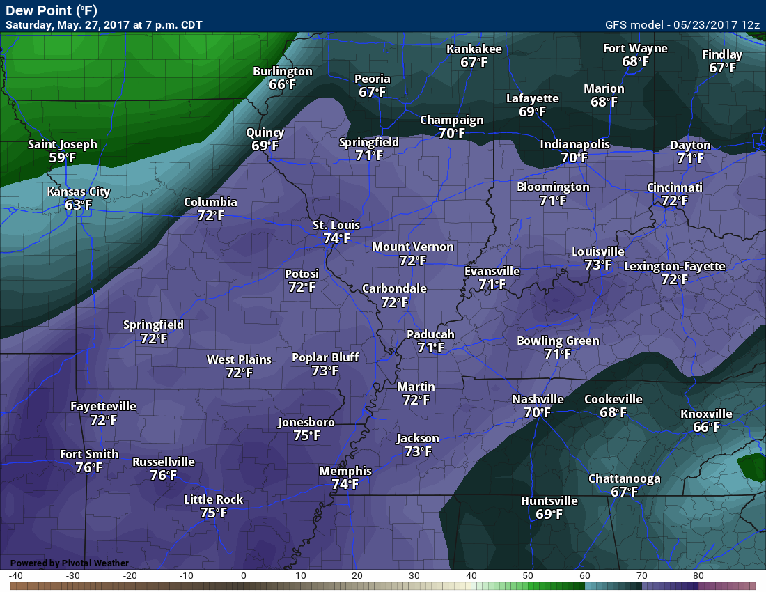
Dew points will be quite high. It will feel muggy (if this verifies).
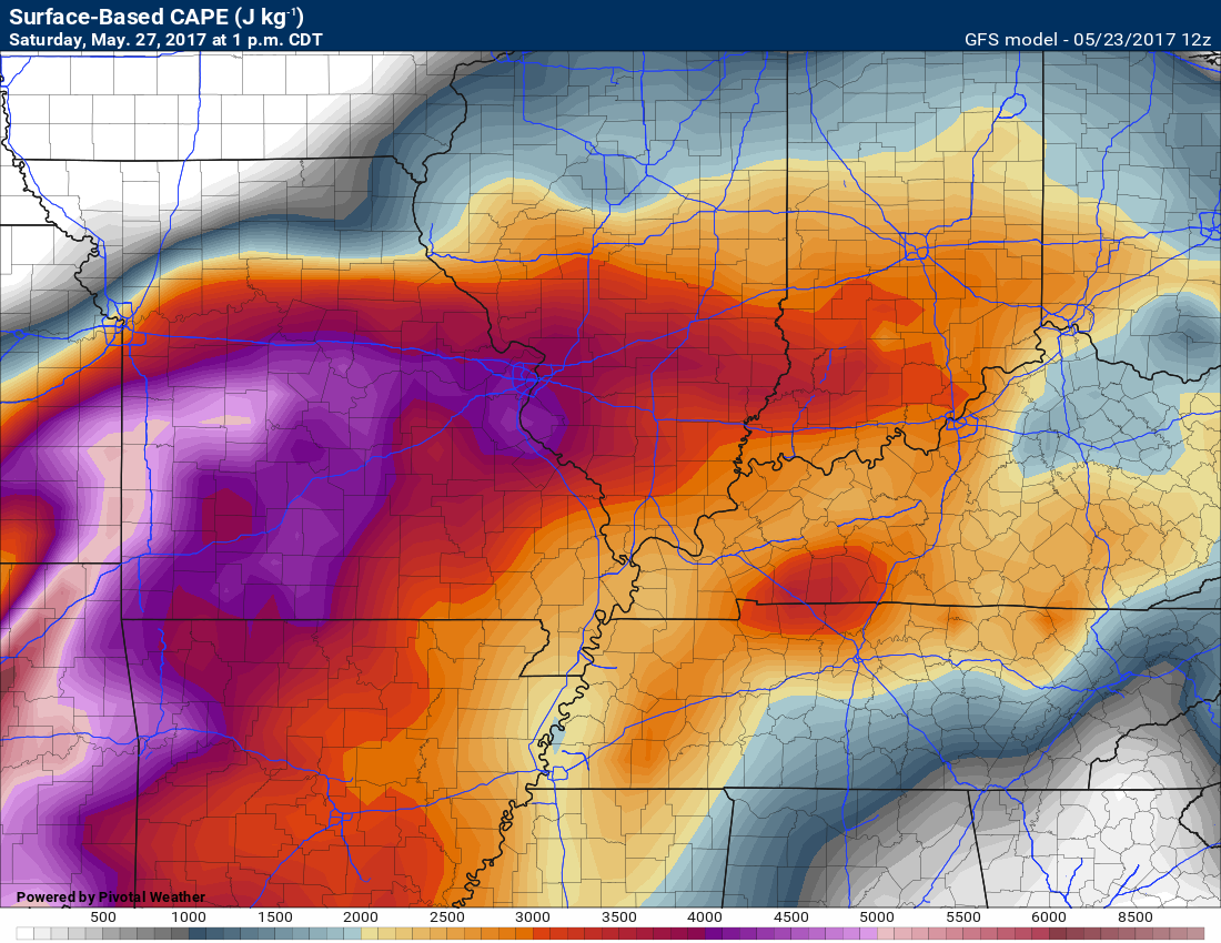
Let’s look at CAPE. CAPE is a measure of instability in the atmosphere. Higher CAPE equals stronger storm potential.
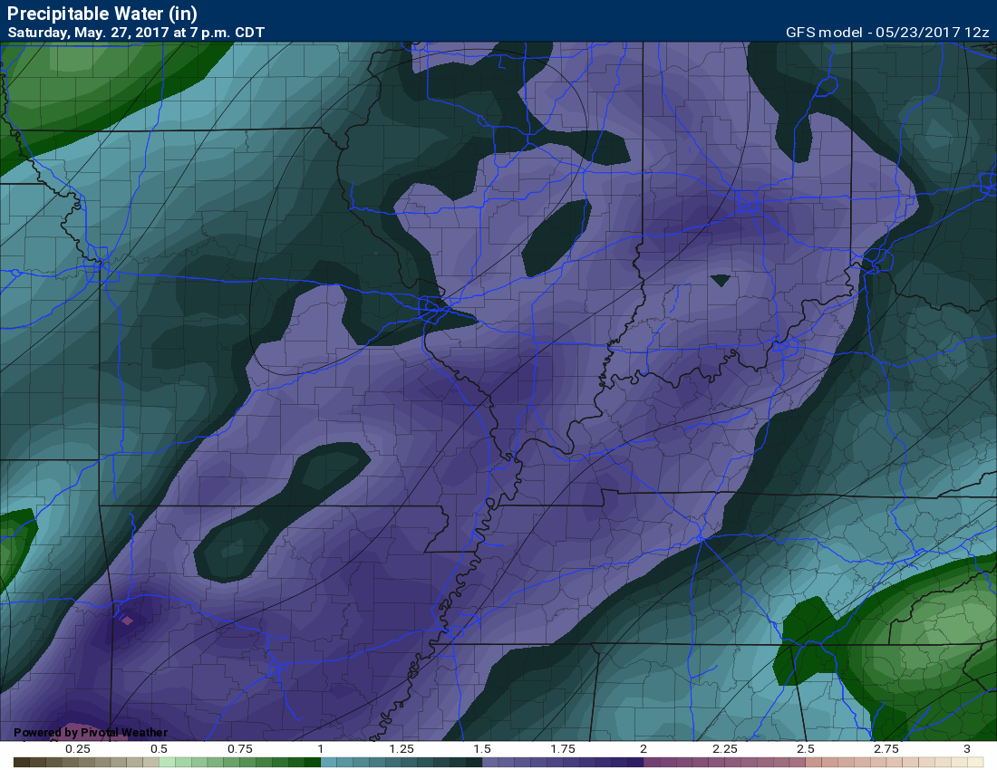
This next graphic is the PWAT map. This is how much moisture is in the entire atmosphere from top to bottom. Higher numbers equal a better chance for heavy downpours. These are high numbers.
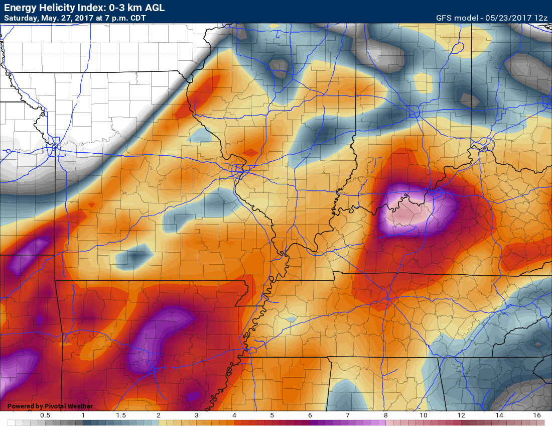
EHI numbers are also climbing. This is used to forecast spin in the atmosphere. These numbers give off a severe weather signal.
Sunday into Monday:
The bulk of the rain should exit by Sunday and Monday. Perhaps a few showers on Sunday, but I am currently forecasting the bulk of the rain to push eastward by that time. Let’s hope. It would be nice to have a dry Sunday and Monday. This is a holiday weekend.
Monday will have a slight chance for a shower (hoping to remove that chance as we move forward).
Rainfall totals between now and Sunday will vary considerably. As you know, thunderstorms can double or triple anticipated rainfall totals. This event will be no different. Where thunderstorms occur you could pick up a quick one to two inches of rain.
Odds favor most of the region receiving 0.40″ to 0.80″. There will, as always, be those who receive more and some who receive less. Spring and summer precipitation patterns are like that.
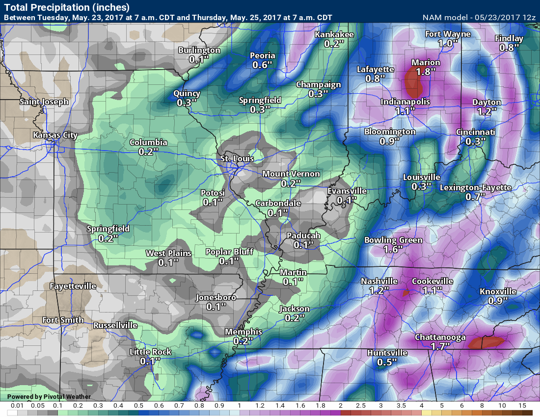
Here is the NAM rainfall forecast from now through 7 am on Thursday.
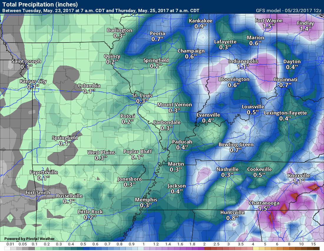
Here is the GFS rainfall totals between now and 7 am on Thursday
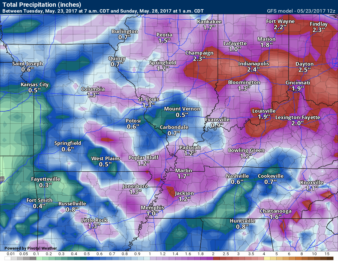
Here is the forecast rainfall totals from the GFS from now through Sunday.
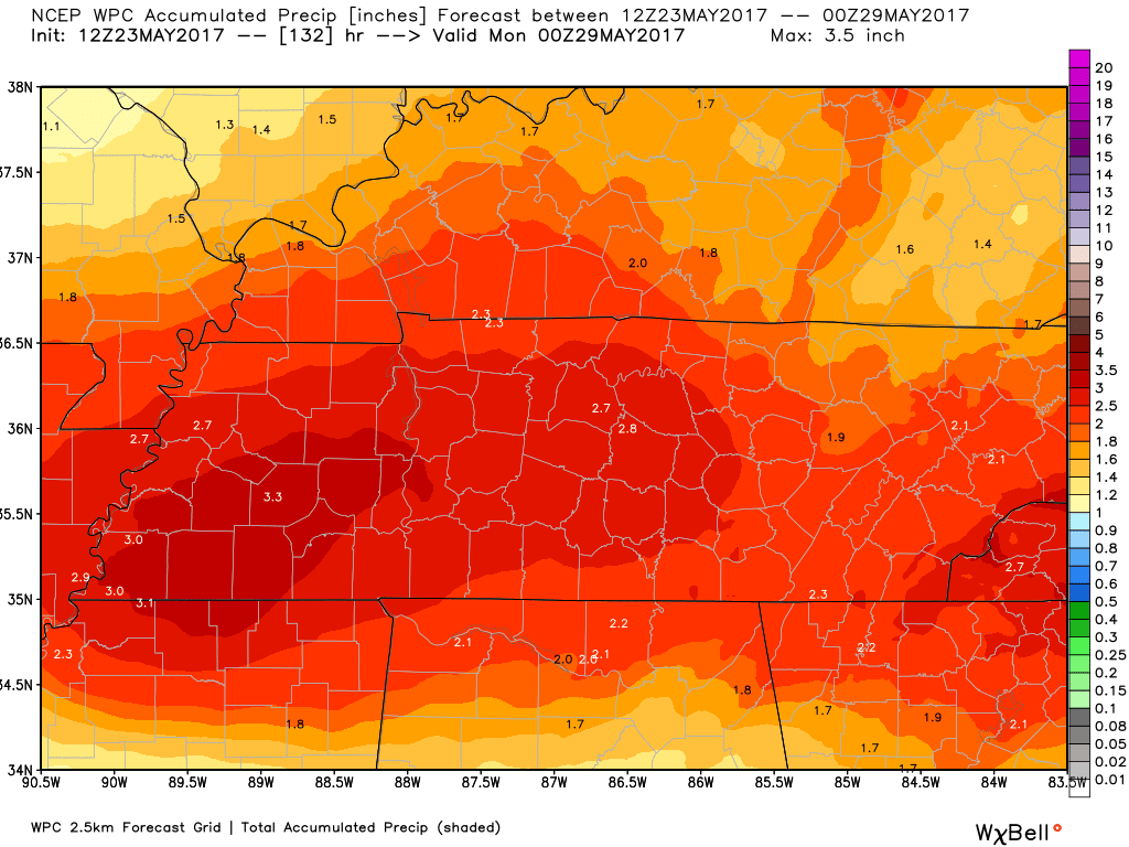
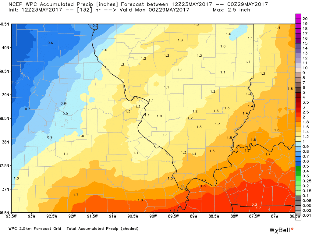
Here is the NOAA/WPC rainfall forecast from now through Sunday morning
I zoomed in on the southeast part of our area and then the northwest part of our area.
and our northwest counties

Find me on Twitter
.

We have regional radars and local city radars – if a radar does not update then try another one. Occasional browsers need their cache cleared. You may also try restarting your browser. That usually fixes the problem. Occasionally we do have a radar go down. That is why I have duplicates. Thus, if one fails then try another one.
During the winter you can track snow and ice by clicking the winterize button on the local city view interactive radars.
If you have any problems then please send me an email beaudodson@usawx.com
Interactive Weather Radar Page. Choose the city nearest your location: Click this link—
National interactive radar: Click this link.
Local interactive city radars include St Louis, Mt Vernon, Evansville, Poplar Bluff, Cape Girardeau, Marion, Paducah, Hopkinsville, Memphis, Nashville, Dyersburg, and all of eastern Kentucky. These are interactive radars. Local city radars – click here
.

The official 6-10 day and 8-14 day temperature and precipitation outlook. Check the date stamp at the top of each image (so you understand the time frame).
.
The forecast maps below are issued by the Weather Prediction Center (NOAA)
.

.

.
The latest 8-14 day temperature and precipitation outlook. Note the dates are at the top of the image. These maps DO NOT tell you how high or low temperatures or precipitation will be. They simply give you the probability as to whether temperatures or precipitation will be above or below normal.
.


.
The Beau Dodson Weather APP is ready for Apple and Android users. The purpose of this app is for me to deliver your text messages instantly. ATT and Verizon have not always been reliable when it comes to speed. The app allows instant delivery.
Some of you have asked if you can keep receiving the texts on your phone and the app. The answer to that is, yes. The Android app will automatically allow that to happen. On the Apple app, however, you will need to go into your app and click settings. Make sure the green tab is OFF. Off means you will still receive the texts to your phone and the app. If you have any questions, then email me at beaudodson@usawx.com
The app is for text subscribers.
The direct download, for the Apple app, can be viewed here
https://itunes.apple.com/us/app/id1190136514
If you have not signed up for the texting service then you may do so at www.beaudodsonweather.com

The Android app is also ready.
Remember, the app’s are for www.weathertalk.com subscribers. The app allows your to receive the text messages faster than ATT and Verizon.
Here is the download link for the Android version Click Here

——————————————————–
If you have not signed up for the texts messages, then please do. Link www.beaudodsonweather.com
Your support helps with the following:

and


Who do you trust for your weather information and who holds them accountable?
I have studied weather in our region since the late 1970’s. I have 39 years of experience in observing our regions weather patterns. My degree is in Broadcast Meteorology and a Bachelor’s of Science.
My resume includes:
Member of the American Meteorological Society.
NOAA Weather-Ready Nation Ambassador.
Meteorologist for McCracken County Emergency Management. I served from 2005 through 2015.
Meteorologist for McCracken County Rescue. 2015 through current
I own and operate the Southern Illinois Weather Observatory.
I am the chief meteorologist for Weather Talk LLC. I am the owner of Weather Talk LLC.
I am also a business owner in western Kentucky.
Recipient of the Mark Trail Award, WPSD Six Who Make A Difference Award, Kentucky Colonel, and the Caesar J. Fiamma” Award from the American Red Cross.
In 2005 I helped open the largest American Cross shelter in U.S. history in Houston, Texas. I was deployed to help after Hurricane Katrina and Hurricane Rita. I was a shelter manager of one of the Houston, Texas shelter divisions.
In 2009 I was presented with the Kentucky Office of Highway Safety Award.
Recognized by the Kentucky House of Representatives for my service to the State of Kentucky leading up to several winter storms and severe weather outbreaks.
If you click on the image below you can read the Kentucky House of Representatives Resolution.

I am also President of the Shadow Angel Foundation which serves portions of western Kentucky and southern Illinois.
There is a lot of noise on the internet. A lot of weather maps are posted without explanation. Over time you should learn who to trust for your weather information.
My forecast philosophy is simple and straight forward.
- Communicate in simple terms
- To be as accurate as possible within a reasonable time frame before an event
- Interact with you on Twitter, Facebook, email, texts, and this blog
- Minimize the “hype” that you might see on some television stations or through other weather sources
- Push you towards utilizing wall-to-wall LOCAL TV coverage during severe weather events
Many of the graphics on this page are from www.weatherbell.com
WeatherBell is a great resource for weather model guidance.


You can sign up for my AWARE email by clicking here I typically send out AWARE emails before severe weather, winter storms, or other active weather situations. I do not email watches or warnings. The emails are a basic “heads up” concerning incoming weather conditions