We have some great sponsors for the Weather Talk Blog. Please let our sponsors know that you appreciate their support for the Weather Talk Blog.
Milner and Orr Funeral Home and Cremation Services located in Paducah, Kentucky and three other western Kentucky towns – at Milner and Orr they believe in families helping families. You can find Milner and Orr on Facebook, as well.
![]()

This forecast update covers far southern Illinois, far southeast Missouri, and far western Kentucky. See the coverage map on the right side of the blog.
Remember that weather evolves. Check back frequently for updates, especially during active weather.
The forecast numbers below may vary a bit across the region. These are the averages.
Tuesday Night – Mostly clear in the evening. Increasing clouds after midnight. Lows mostly in the 50’s with light winds. Can’t rule out a few upper 40’s over far northern counties. Cool, either way.
Wednesday – A chance for showers and thunderstorms moving in from the west during the late morning and afternoon hours. Severe weather is not anticipated. Temperatures will be below normal with highs mostly in the upper 60’s to middle 70’s. Northeast/east winds at 5-10 mph.
My confidence in this part of the forecast verifying is high
Should I cancel my outdoor plans? Rain is possible
WEATHER RADAR PAGE – Click here —
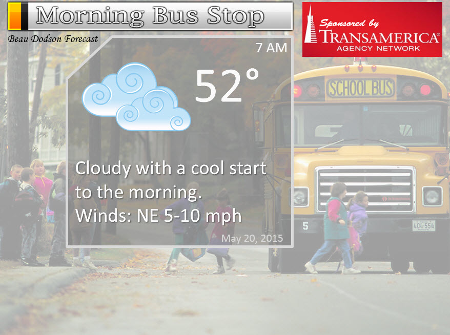
Morning School Bus Stop Weather – Some cloud and sun. Cool start to the day with temperatures in the 50’s. Light winds.
—————————————————————————————-
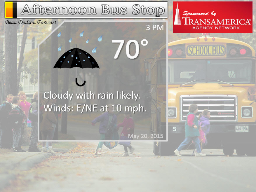
Afternoon School Bus Stop Weather – Cloudy with a chance for a shower or thunderstorms. Temperatures mostly in the upper 60’s and lower 70’s
Wednesday night – A chance for showers and maybe a rumble of thunder. Cooler. Lows in the middle 40’s and lower 50’s. North/northwest winds at 5-10 mph.
My confidence in this part of the forecast verifying is high
Should I cancel my outdoor plans? Rain is possible
Thursday – Quite a few clouds around and cooler than normal temperatures. Highs mostly in the upper 60’s and 70’s. Winds from the north at 5-10 mph.
My confidence in this part of the forecast verifying is medium
Should I cancel my outdoor plans? No
Thursday night – Mostly clear and chilly. Lows will be in the 40’s. North winds at 5 mph.
My confidence in this part of the forecast verifying is high
Should I cancel my outdoor plans? No
Friday – Partly sunny and warmer with highs in the 70’s. Variable winds at times. East winds at 5-10 mph.
My confidence in this part of the forecast verifying is high
Should I cancel my outdoor plans? No
Right now…Friday and Saturday look nice (cool). Rain returns by Sunday and Monday (see details in the extended discussion)
![]()
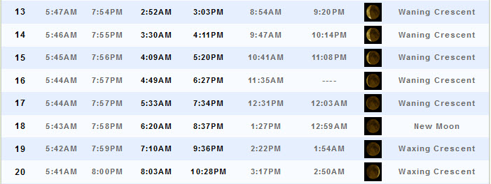
Sunrise and Sunset Times – Click Here

The School Bus Stop Forecast is sponsored by TransAmerica Agency Network Paducah District – you can visit their Facebook page here and their home page here
Current Temperatures Around The Local Area


Don’t forget to check out the Southern Illinois Weather Observatory web-site for weather maps, tower cams, scanner feeds, radars, and much more! Click here

An explanation of what is happening in the atmosphere over the coming days…
Highlights
1. Below normal temperatures this week
2. More rain chances by Wednesday afternoon and night
3. Extended discussion (scroll down towards middle/bottom of blow) has more rain and heavy storms
Here comes the rain again. Some of you were complaining because you had not received much rain during the Month of May. Of course for 90% of us…that is no longer the case.
More rain will fall today and tonight. Expect showers and thunderstorms to be widespread. Not sure how much lightning and thunder there will be, but some rumbles likely. I am not expecting severe weather. That is the good news. Always some good news in May…when severe weather is not in the forecast. We have been very very fortunate this year. For the most part.
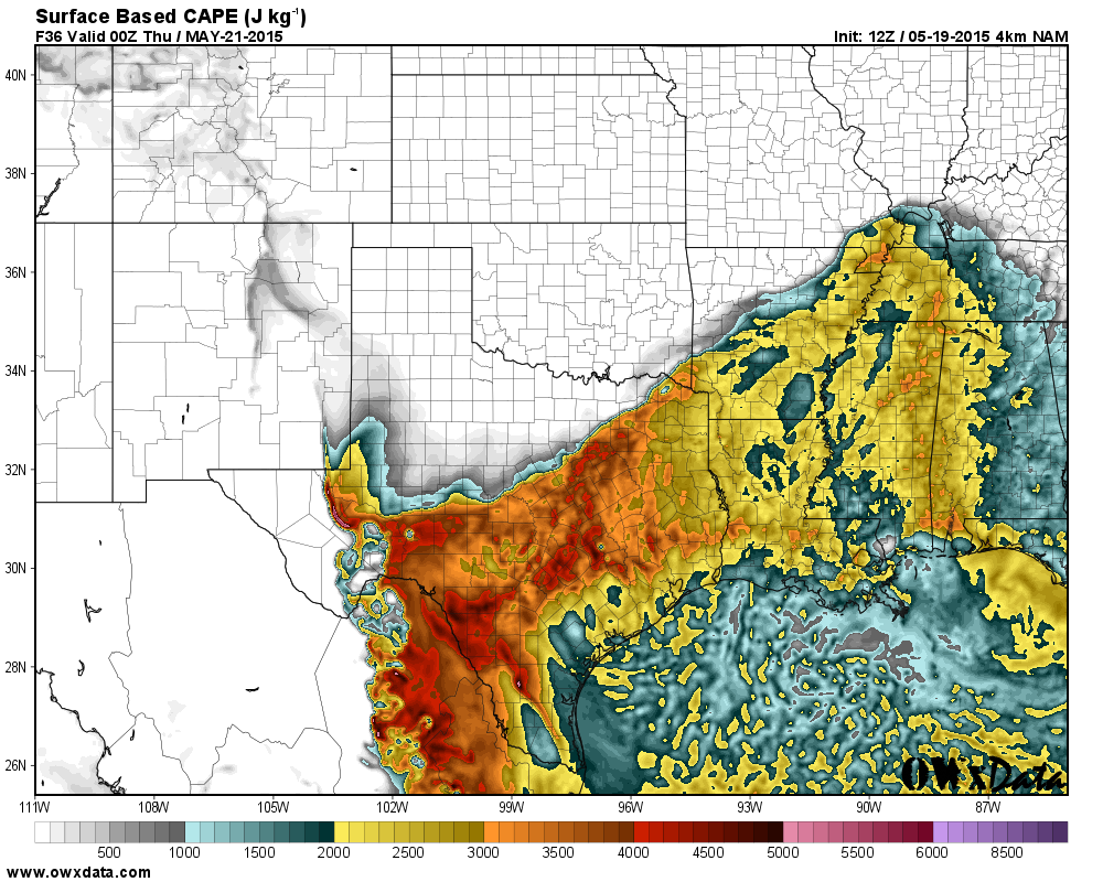
CAPE values for Wednesday afternoon attempt to flirt with our region. CAPE is energy for storms (layman’s terms)
Perhaps rumbles of thunder will be possible. Again, not expecting severe storms

Live Lightning Data – zoom and pan: Click here
Live Lightning Data with sound (click the sound button on the left side of the page): Click here
Rainfall totals won’t be extreme today or tonight…generally I am expecting 0.25″-0.70″ with locally heavier amounts if thunderstorms occur. Some debate on the amount of thunderstorm activity. Instability isn’t great.
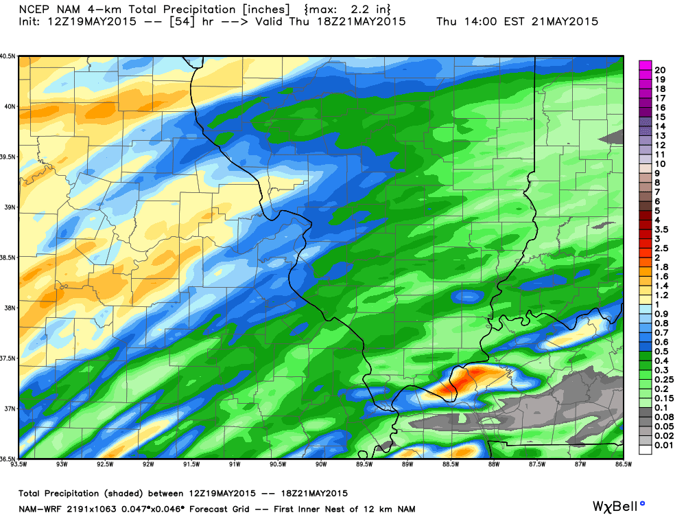
Here is what the high resolution WRF model is forecasting for Wednesday’s rainfall totals. You can see some pockets of heavier rain on this map. We will see how it goes. The heavier totals should be just a bit to our north and northwest (see that on the map).
Images below are from weatherbell.com and you can click the image for a larger view
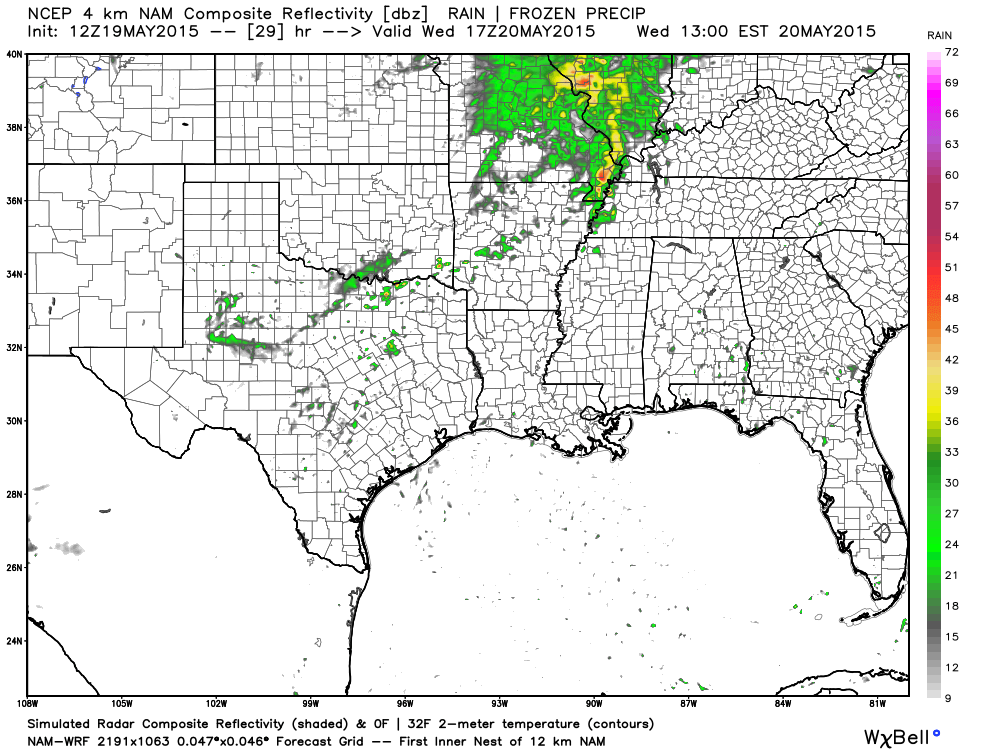
Here is the future-cast radar from the WRF model.
This first map shows you what radar might look like around 11 am to 2 pm
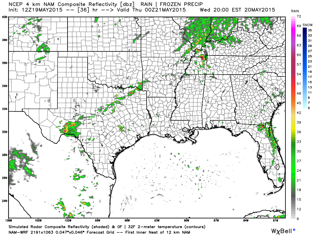
This next map is for Wednesday evening. Again, this is the future-cast radar. What radar MIGHT look like…assuming this model is correct.
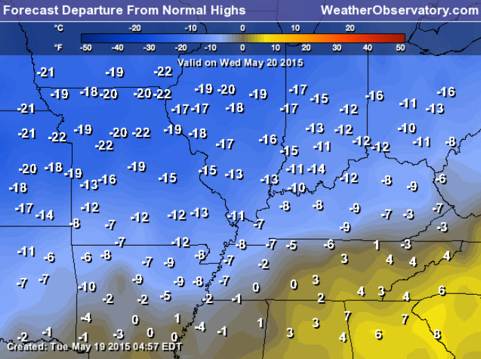
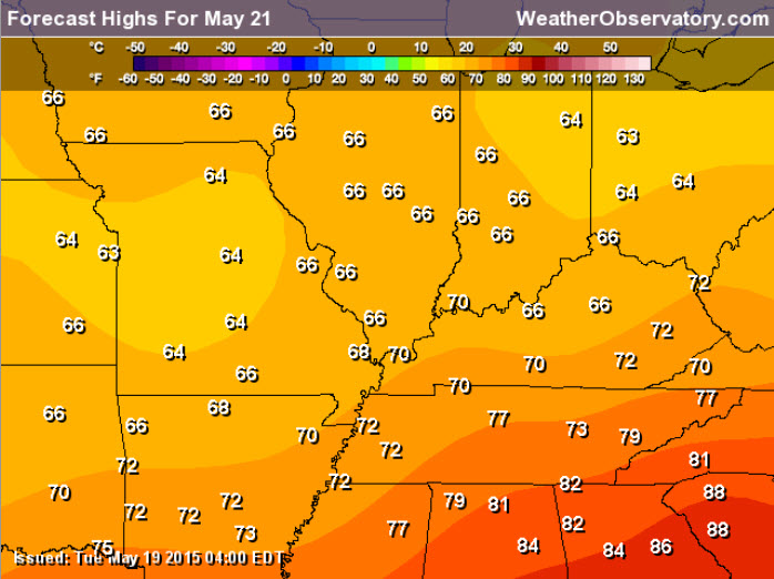
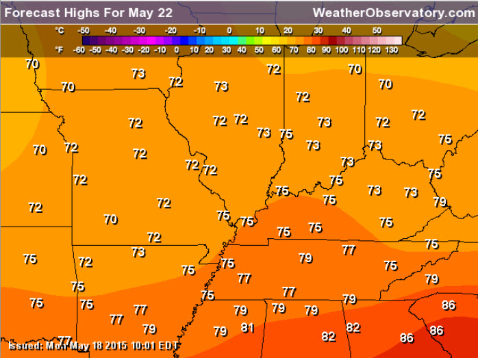
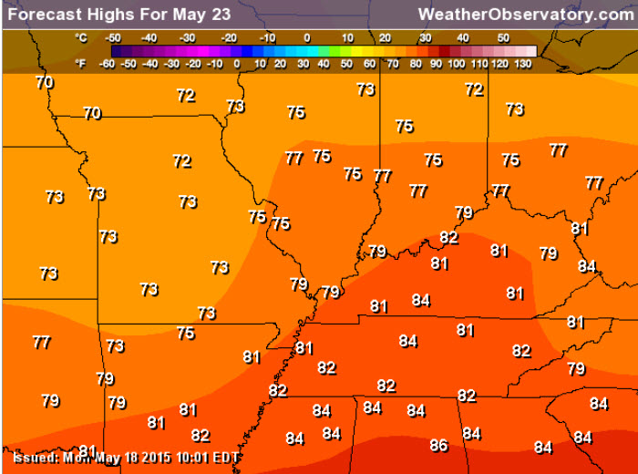
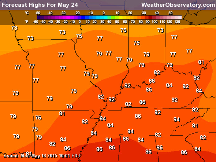
Temperatures will be well below normal for much of this week. How many degrees below normal? Well, I am glad you asked. I have a graphic for that! Normal high temperatures this time of the year are around 78 degrees and normal low temperatures are around 56 degrees.
Here are the departures for Wednesday. How many degrees below normal will high temperatures be?
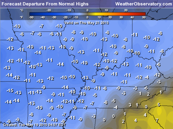
And for Thursday?
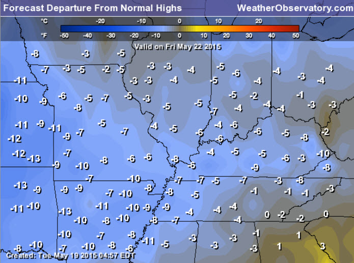
And for Friday
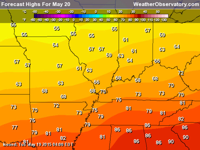
Wednesday high temperatures
Thursday high temperatures
See the extended discussion below for the weekend details (which unfortunately does have rain and storms included in it)
Don’t forget to support our sponsors!

No real changes to the ongoing forecast. Updated the Wednesday timing for precipitation. Late morning into the afternoon. Rain will end on Wednesday night…late.

No major concerns. If thunderstorms develop on Wednesday afternoon or night then a few lightning strikes will occur. Severe weather is not in the forecast.

Rain chances increase Wednesday afternoon and night. Umbrella might be needed at times. Lightning is the only concern for outdoor events. Some question on timing of coverage of this rain event. But, a few lightning strikes possible.
Check out our sponsors! There are more on the right side bar of the page, as well. Be sure and let them know that you appreciate their sponsorship of the WeatherTalk daily weather bulletin.

Premier Portable Buildings proudly serving our region. For more information click the above ad or here
They can also be found on this Facebook page
G&C Multi-Services out of Paducah, Kentucky. G & C Multi-Services is a service provider in Western Kentucky that provides industrial and commercial equipment fabrication, machine troubleshooting, repair and maintenance, and installation. They can custom fabricate steel, stainless, and aluminum products per customer specifications.
Visit their web-site here. Or click the ad below! Facebook page.


Wortham Dental Care located in Paducah, Kentucky. The gentle dentist. Mercury free dentistry. They also do safe Mercury removal. You can find Wortham Dental Care on Facebook, as well

Trover’s Equipment and Lawn Care – Family owned and operated! They are a dealer for Snapper, Simplicity, Snapper Pro, Bad Boy Mowers, and Intimidator Utility Vehicles. They are a Stihl and Dolmar power products dealer. They also are a dealer for Briggs & Stratton, Kohler gas & diesel engines, and Kawasaki engines. They service and repair just about any brand. You can find them on Facebook, as well

Visit their web-site here. Or, you can also visit their Facebook page.

Endrizzi’s Storm Shelters – For more information click here. Endrizzi Contracting and Landscaping can be found on Facebook, as well – click here

Gary Eckelkamp’s web-site click the above banner or click here
.

Here are the current river stage forecasts. You can click your state and then the dot for your location. It will bring up the full forecast and hydrograph.
Click Here For River Stage Forecasts…
Here are some current forecast hydrographs. These will be updated each day with new information.

Can we expect severe thunderstorms over the next 24 to 48 hours? Remember that a severe thunderstorm is defined as a thunderstorm that produces 58 mph winds or higher, quarter size hail or larger, and/or a tornado.
Thunderstorm threat level is ONE for Wednesday and Wednesday night and ZERO for Thursday and Friday.
During inclement weather, anyone with outdoor events should monitor radars and lightning data. Even though a thunderstorm might not be severe, it could certainly cause problems if you have an outdoor sporting event or are camping.
.
Wednesday Severe Weather Outlook – Severe Weather Is Not Anticipated. Thunder possible.
Thursday Severe Weather Outlook – Severe Weather Is Not Anticipated.
Friday Severe Weather Outlook – Severe Weather Is Not Anticipated
Saturday Severe Weather Outlook – Severe Weather Is Not Anticipated
Sunday Severe Weather Outlook – Monitor updates
Monday Severe Weather Outlook – Monitor updates
Wednesday outlook into Wednesday night is a ONE


How much precipitation should we expect over the next few days?
As we enter the late spring and summer months, keep in mind that slow moving thunderstorms can always produce locally heavy rainfall totals. This is no secret to all of you who are farmers. Your neighbors could pick up 1″ of rain from a thunderstorm, meanwhile you are sitting on dry ground. Forecasting exact rainfall totals during this time of the year can be tricky, at best.
Rain chances increase on Wednesday afternoon and Wednesday night. Amounts don’t appear to get out of control (unlike some of the recent events). Totals of 0.25″-0.70″ appear possible. A thunderstorm can always produce a little more. Some questions remain on the coverage of this first event. Some areas might remain dry.
Our next rainfall event could be heavier. It arrives at some point on Sunday into early next week. I still need to work on the timing.
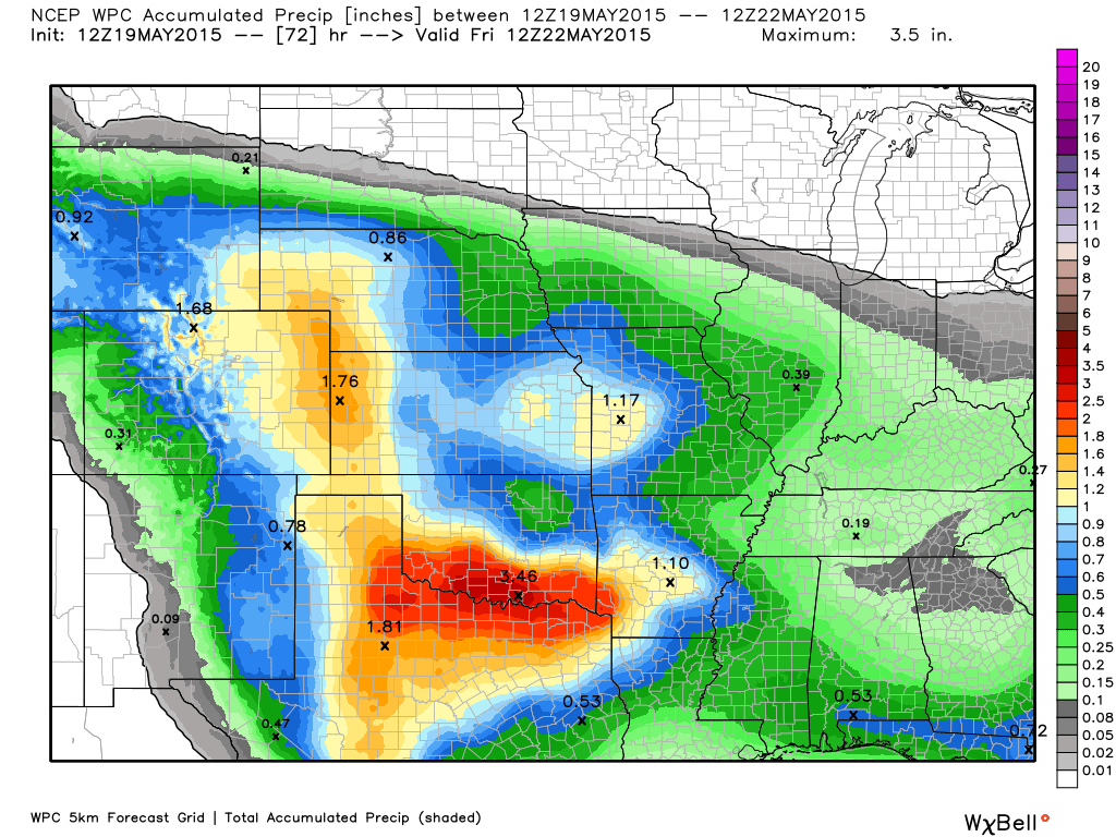
Here are the forecast rainfall forecasts through Thursday. The WPC (arm of NOAA) has fairly low totals for our region. We will see how it goes. I went 0.25″ to 0.70″. The amounts will vary a bit. Perhaps the heaviest over our northern counties vs southern.
Rainfall images are from weatherbell.com and you can click them to increase the size
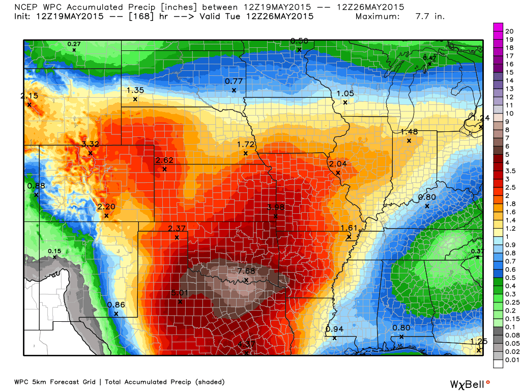
Here are the forecast rainfall totals into next week. Quite a bit more rain. As the last two weekends have proven, these totals could be locally MUCH higher. Remember, some of our counties (quite a few) have experienced 4″-6″+ of rain from the last 2 events.
Poor Texas. Climate scientists were screaming that they would be in severe drought for years to come. Now they can’t get rid of the rain. Major rain expected in Texas over the coming days. Flooding.

This section of the blog is speculative forecast information. Because it is past the range of what meteorologists can forecast accurately, it should be considered speculation. Anything past day 5 is considered a long range forecast.
Highlights
1. Thunderstorm chances return late in the weekend into early next week.
2. Unsettled weather over coming weeks. Plenty of rain and storm chances.
I continue to forecast frequent rain chances through the end of the month. If you remember a few weeks ago, I warned of this pattern. Frequent rounds of moderate to heavy rain. But, perhaps less concerns on severe storms. That forecast will continue into June.
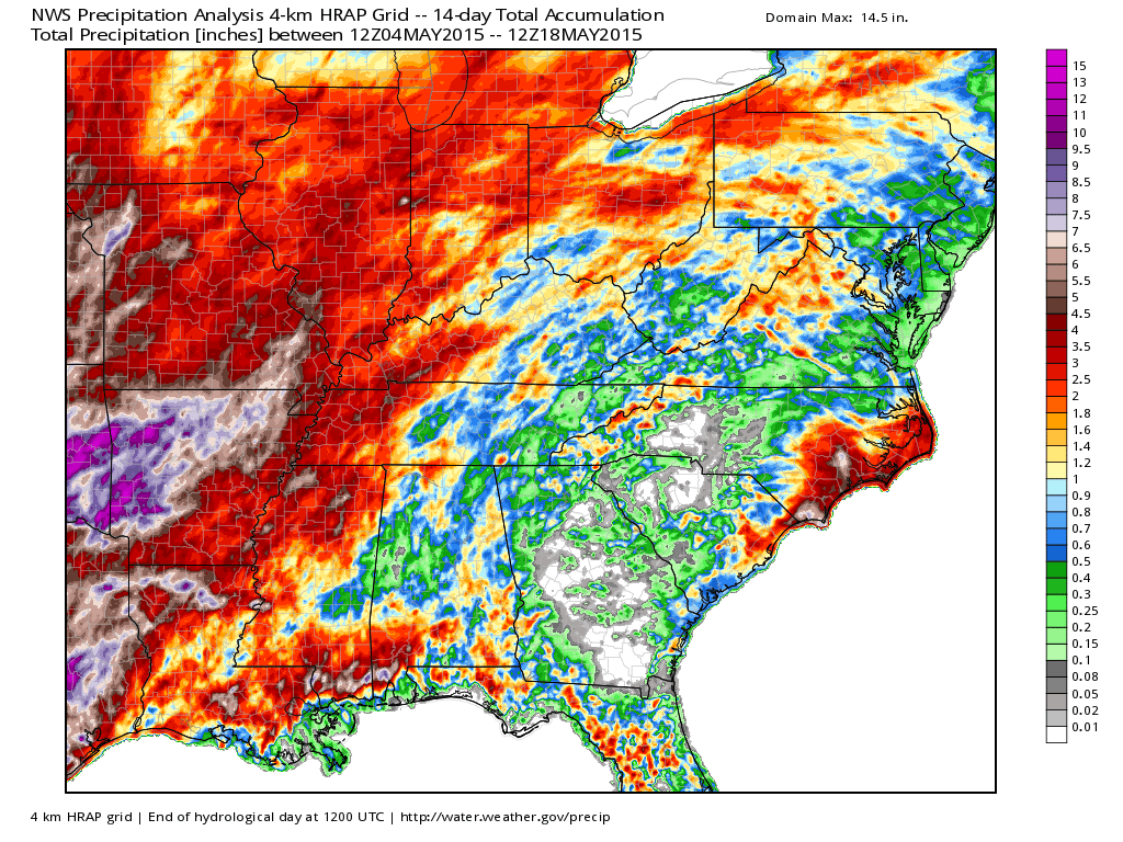
The real question is how much rain will fall. The last 14 days have brought many inches of rain to some of our counties. Here is a broad-brushed map showing the rainfall totals since May 4th. I noticed some of these numbers aren’t high enough for some of our local counties. But, you get the general idea. This pattern will continue over the coming weeks.
Image is from weatherbell.com and you can click the image for the larger view. Scale is on the right.
Temperatures will remain near normal over the weekend to perhaps a bit above normal by Sunday.
Friday high temperatures
Saturday high temperatures
Sunday high temperatures
I don’t have the best news for the holiday weekend, at least part of it.
Saturday should be fine! Great day to get out and enjoy the regions activities. Sunday morning should also be dry. There is some debate about how soon to bring shower and thunderstorm chances back into the area Saturday night and Sunday morning. For now, I will leave it dry.
By Sunday afternoon and Sunday night the region will come under the influence of a storm system that will push out of the Central Plains into Iowa. This will increase our precipitation chances. Some locally heavy rain, as well.
Monday will have shower and thunderstorm chances. There will be a few periods of widespread showers and thunderstorms…I will need to time those out as we draw closer to the event.
There are questions on Monday’s coverage for precipitation. Not saying a wash out, but monitor updates.
Long range…unsettled with frequent rounds of rain and thunderstorms into the middle of June. Above normal precipitation with perhaps near normal temperatures. Some question as to whether we might experience above normal temperatures over our southeast counties especially. Main concern will be heavy rain.


Regional Radar
![]()
Current WARNINGS (a warning means take action now). Click on your county to drill down to the latest warning information. Keep in mind that there can be a 2-3 minute delay in the updated warning information.
I strongly encourage you to use a NOAA Weather Radio or warning cell phone app for the most up to date warning information. Nothing is faster than a NOAA weather radio.


Color shaded counties are under some type of watch, warning, advisory, or special weather statement. Click your county to view the latest information.

Missouri Warnings

Illinois Warnings

Kentucky Warnings

Please visit your local National Weather Service Office by clicking here. The National Weather Service Office, for our region, is located in Paducah, Kentucky. They have a lot of maps and information on their site. Local people…local forecasters who care about our region.

Here is the official 6-10 day and 8-14 day temperature and precipitation outlook. Check the date stamp at the top of each image (so you understand the time frame).
The forecast maps below are issued by the Weather Prediction Center (NOAA).


The latest 8-14 day temperature and precipitation outlook. Note the dates are at the top of the image. These maps DO NOT tell you how high or low temperatures or precipitation will be. They simply give you the probability as to whether temperatures or precipitation will be above or below normal.


Who do you trust for your weather information and who holds them accountable?
I have studied weather in our region since the late 1970’s. I have 37 years of experience in observing our regions weather patterns. My degree is in Broadcast Meteorology from Mississippi State University and an Associate of Science (AS). I am currently working on my Bachelor’s Degree in Geoscience. Just need to finish two Spanish classes!
I am a member of the American Meteorological Society. I am a NOAA Weather-Ready Nation Ambassador. And, I am the Meteorologist for McCracken County Emergency Management.
I own and operate the Southern Illinois Weather Observatory.
There is a lot of noise on the internet. A lot of weather maps are posted without explanation. Over time you should learn who to trust for your weather information.
My forecast philosophy is simple and straight forward.
- Communicate in simple terms
- To be as accurate as possible within a reasonable time frame before an event
- Interact with you on Twitter, Facebook, and the blog
- Minimize the “hype” that you might see on television or through other weather sources
- Push you towards utilizing wall-to-wall LOCAL TV coverage during severe weather events
I am a recipient of the Mark Trail Award, WPSD Six Who Make A Difference Award, Kentucky Colonel, and the Caesar J. Fiamma” Award from the American Red Cross. In 2009 I was presented with the Kentucky Office of Highway Safety Award. I was recognized by the Kentucky House of Representatives for my service to the State of Kentucky leading up to several winter storms and severe weather outbreaks.
If you click on the image below you can read the Kentucky House of Representatives Resolution.

I am also President of the Shadow Angel Foundation which serves portions of western Kentucky and southern Illinois.

Many of my graphics are from www.weatherbell.com – a great resource for weather data, model data, and more


This blog was inspired by ABC 33/40’s Alabama Weather Blog – view their blog
Current tower cam view from the Weather Observatory- Click here for all cameras.

Southern Illinois Weather Observatory

The Weather Observatory

Southern Illinois Weather Observatory
WSIL TV 3 has a number of tower cameras. Click here for their tower camera page & Illinois Road Conditions

Marion, Illinois
WPSD TV 6 has a number of tower cameras. Click here for their tower camera page & Kentucky Road Conditions & Kentucky Highway and Interstate Cameras

Downtown Paducah, Kentucky
Benton, Kentucky Tower Camera – Click here for full view

Benton, Kentucky

I24 Paducah, Kentucky

I24 Mile Point 9 – Paducah, KY

I24 – Mile Point 3 Paducah, Kentucky

You can sign up for my AWARE email by clicking here I typically send out AWARE emails before severe weather, winter storms, or other active weather situations. I do not email watches or warnings. The emails are a basic “heads up” concerning incoming weather conditions.