Wednesday morning update
.

.

This forecast update covers far southern Illinois, far southeast Missouri, and far western Kentucky. See the coverage map on the right side of the blog
Some rivers remain above flood stage.
.
May 16, 2017
Tuesday Night Forecast Details:
Forecast: Partly cloudy. Increasing winds through the night. Mild.
Temperatures: MO ~ 65 to 70 IL ~ 65 to 70 KY ~ 65 to 70 TN ~ 65 to 70
Winds: South and southwest at 8 to 16 mph with gusts to 35 mph. Higher winds late vs earlier.
My confidence in the forecast verifying: High. This forecast should verify.
What impacts are anticipated from the weather? Gusty winds.
Is severe weather expected? No
The NWS defines severe weather as 58 mph winds or great, 1″ hail or larger, and/or tornadoes
What is the chance of precipitation? MO ~ 20% IL ~ 20% KY ~ 10% TN ~ 10%
Coverage of precipitation: None to isolated
Should I cancel my outdoor plans? No
.
NOTE
Confidence on timing of showers and thunderstorms, in the extended forecast, is rather low. We will have almost daily chances from Wednesday evening into Sunday. There will be several peak times for rain, but that is the part of the forecast that will need fine tuning.
If you have outdoor activities or farming, then monitor updates. There will be rain on radar.
.
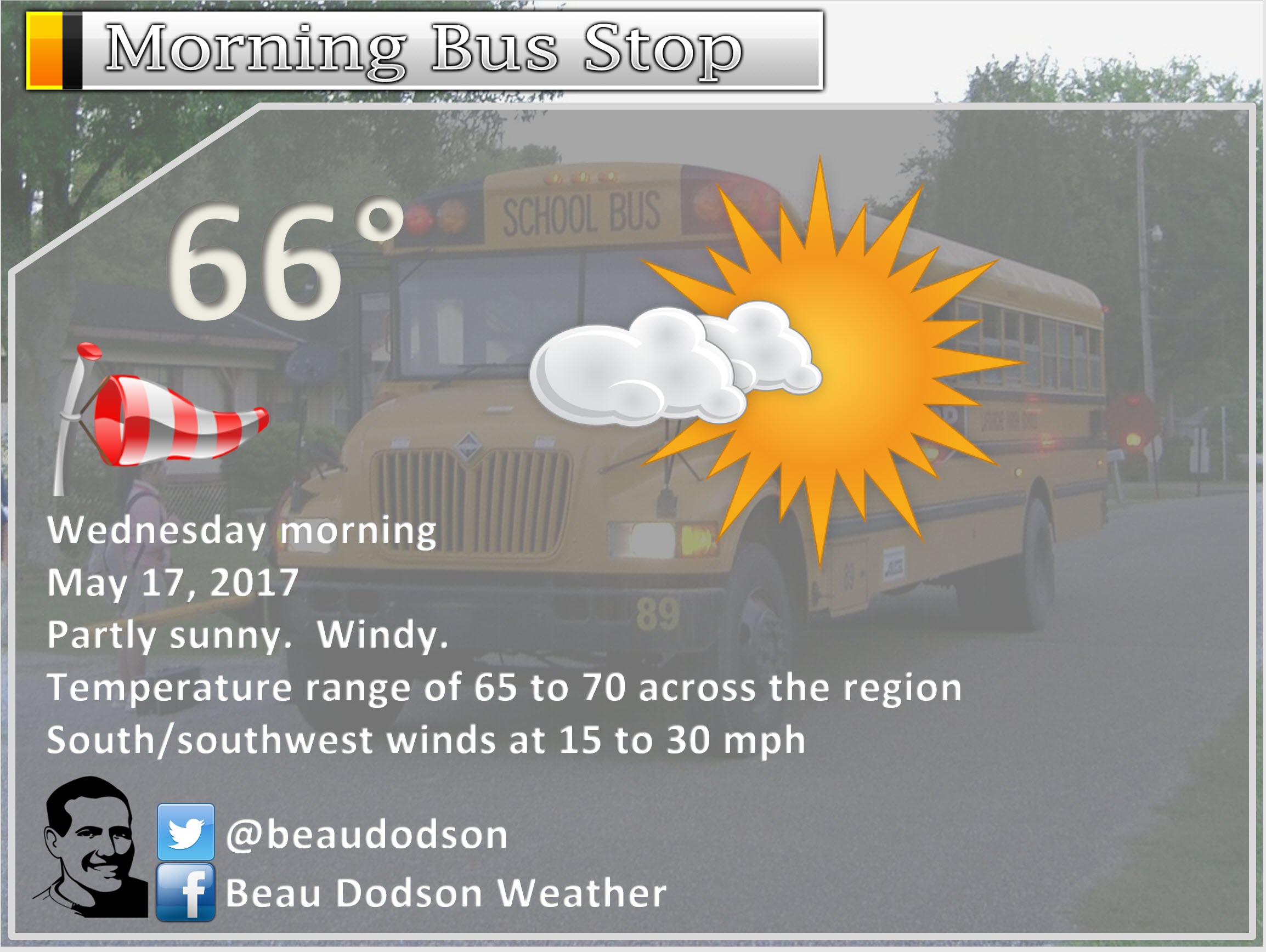
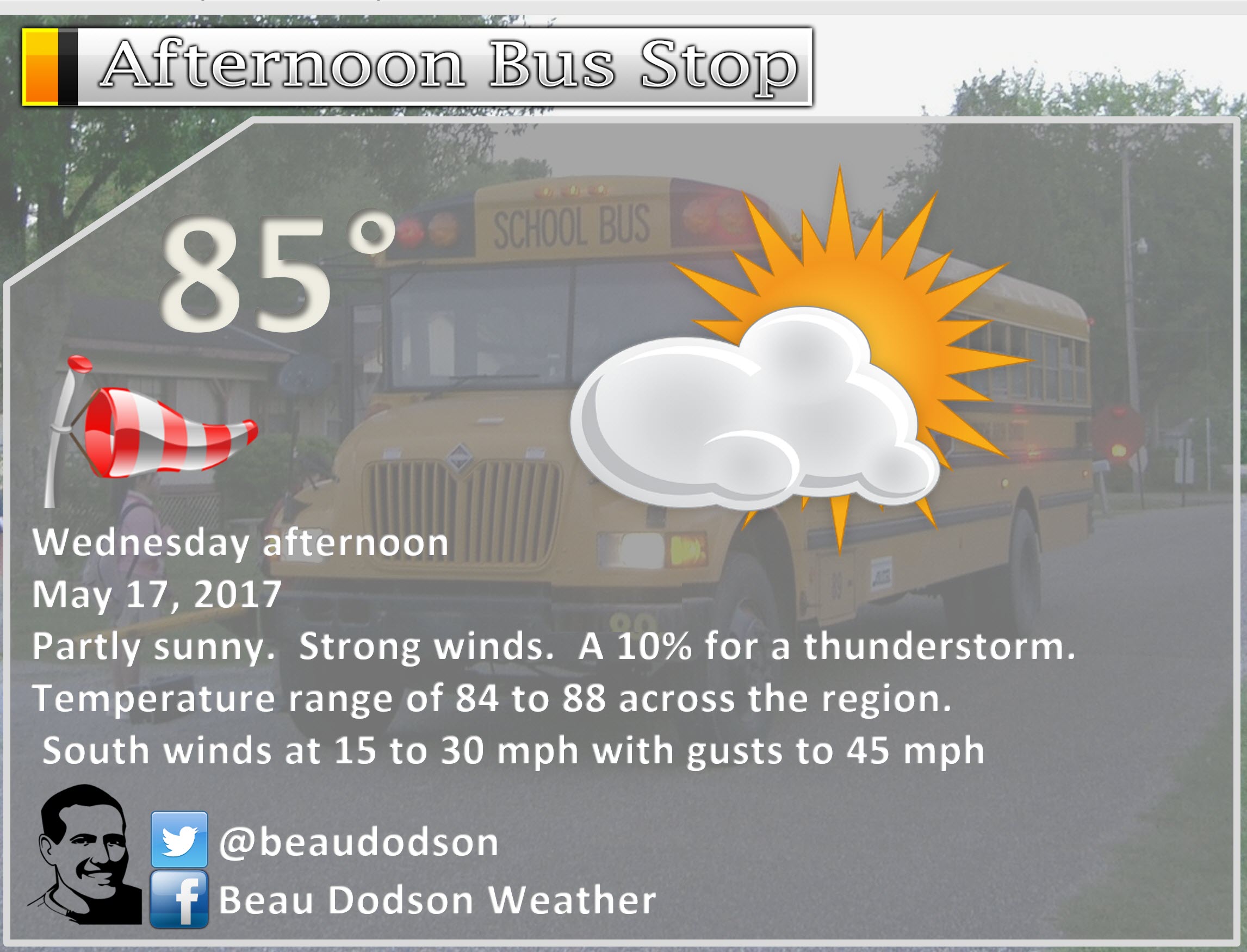
May 17, 2017
Wednesday Forecast Details
Forecast: High winds possible. Partly sunny. Warm. Well above normal temperatures. A slight chance for a thunderstorm during the afternoon (mainly over southeast Missouri and southwest Illinois). Non-thunderstorm winds could gust above 45 mph.
Temperatures: MO ~ 82 to 86 IL 82 to 86 KY 82 to 86 TN 82 to 86
Winds: South and southwest at 8 to 16 mph with gusts to 45 mph. Gusts above 45 mph possible.
What impacts are anticipated from the weather? High winds. Isolated wet roadways. Lightning.
My confidence in the forecast verifying: High. This forecast should verify.
Is severe weather expected? If storms form, they could produce hail and strong winds. Overall severe weather risk is small.
The NWS defines severe weather as 58 mph winds or great, 1″ hail or larger, and/or tornadoes
What is the chance of precipitation? MO ~ 20% IL ~ 20% KY ~ 10% TN ~ 10%
Coverage of precipitation: None to isolated.
Should I cancel my outdoor plans? No, but high winds are possible.
.
Interactive Weather Radar Page. Choose the city nearest your location: Click this link
.
Wednesday Night Forecast Details:
Forecast: Mostly cloudy. A 30% chance for showers and thunderstorms.
Temperatures: MO ~ 64 to 68 IL ~ 64 to 68 KY ~ 64 to 68 TN ~ 64 to 68
Winds: South and southwest at 10 to 25 mph. Higher gusts likely before 11 pm.
My confidence in the forecast verifying: Medium. Some adjustments are possible.
What impacts are anticipated from the weather? Wet roadways. Lightning.
Is severe weather expected? If thunderstorms form, then they could produce hail and strong winds. The overall threat for severe weather is small. A non-zero risk.
The NWS defines severe weather as 58 mph winds or great, 1″ hail or larger, and/or tornadoes
What is the chance of precipitation? MO ~ 40% IL ~ 30% KY ~ 30% TN ~ 30%
Coverage of precipitation: Scattered
Should I cancel my outdoor plans? No, but monitor updated forecasts.
.
.
May 18, 2017
Thursday Forecast Details
Forecast: Partly to mostly cloudy. A 30% for showers and thunderstorms. Warm.
Temperatures: MO ~ 82 to 86 IL 82 to 86 KY 82 to 86 TN 82 to 86
Winds: South and southwest at 7 to 14 mph. Gusty
What impacts are anticipated from the weather? Wet roadways. Lightning.
My confidence in the forecast verifying: Low. Significant adjustments are possible.
Is severe weather expected? Unlikely
The NWS defines severe weather as 58 mph winds or great, 1″ hail or larger, and/or tornadoes
What is the chance of precipitation? MO ~ 30% IL ~ 30% KY ~ 30% TN ~ 30%
Coverage of precipitation: Widely scattered
Should I cancel my outdoor plans? No, but monitor radars. A few storms are possible.
.
Thursday Night Forecast Details:
Forecast: Partly cloudy. A 40% to 50% for showers and thunderstorms.
Temperatures: MO ~ 62 to 66 IL ~ 62 to 66 KY ~ 62 to 66 TN ~ 62 to 66
Winds: South and southwest at 6 to 12 mph with gusts to 20 mph
My confidence in the forecast verifying: Low. Significant adjustments are possible.
What impacts are anticipated from the weather? Wet roadways. Lightning.
Is severe weather expected? Unlikely, but monitor updates.
The NWS defines severe weather as 58 mph winds or great, 1″ hail or larger, and/or tornadoes
What is the chance of precipitation? MO ~ 50% IL ~ 50% KY ~ 40% TN ~ 40%
Coverage of precipitation: Scattered
Should I cancel my outdoor plans? Monitor updates
.
May 19, 2017
Friday Forecast Details
Forecast: Partly cloudy. Warm. A 40% to 50% chance for showers and thunderstorms.
Temperatures: MO ~ 82 to 86 IL 80 to 85 KY 82 to 86 TN 82 to 86
Winds: South and southwest at 6 to 12 mph with gusts to 18 mph
What impacts are anticipated from the weather? Wet roadways and lightning.
My confidence in the forecast verifying: Medium. Some adjustments are possible.
Is severe weather expected? Monitor updates
The NWS defines severe weather as 58 mph winds or great, 1″ hail or larger, and/or tornadoes
What is the chance of precipitation? MO ~ 50% IL ~ 50% KY ~ 40% TN ~ 40%
Coverage of precipitation: Scattered to perhaps numerous.
Should I cancel my outdoor plans? Monitor updates
.
Friday Night Forecast Details:
Forecast: Partly cloudy. A 40% for thunderstorms.
Temperatures: MO ~ 64 to 68 IL ~ 64 to 68 KY ~ 64 to 68 TN ~ 64 to 68
Winds: South and southwest at 5 to 10 mph with gusts to 15 mph
My confidence in the forecast verifying: Low. Significant adjustments are possible.
What impacts are anticipated from the weather? Wet roadways. Lightning.
Is severe weather expected? Monitor updates
The NWS defines severe weather as 58 mph winds or great, 1″ hail or larger, and/or tornadoes
What is the chance of precipitation? MO ~ 40% IL ~ 40% KY ~ 40% TN ~ 40%
Coverage of precipitation: Scattered
Should I cancel my outdoor plans? Monitor updates
.
May 20, 2017
Saturday Forecast Details
Forecast: Partly cloudy. A 30% to 40% for showers and thunderstorms.
Temperatures: MO ~ 82 to 86 IL 82 to 86 KY 82 to 86 TN 82 to 86
Winds: South and southwest at 6 to 12 mph with gusts to 18 mph
What impacts are anticipated from the weather? Lightning. Wet roadways
My confidence in the forecast verifying: Low. Significant adjustments are possible.
Is severe weather expected? Monitor updates
The NWS defines severe weather as 58 mph winds or great, 1″ hail or larger, and/or tornadoes
What is the chance of precipitation? MO ~ 40% IL ~ 40% KY ~ 30% TN ~ 30%
Coverage of precipitation: Scattered
Should I cancel my outdoor plans? Monitor updates
.
Saturday Night Forecast Details:
Forecast: Partly cloudy. A 60% for showers and thunderstorms.
Temperatures: MO ~ 65 to 70 IL ~ 65 to 70 KY ~ 65 to 70 TN ~ 65 to 70
Winds: South and southwest winds at 5 to 10 mph with gusts to 20 mph. Winds may shift more southwest and west after 2 am.
My confidence in the forecast verifying: Low. Significant adjustments are possible.
What impacts are anticipated from the weather? Wet roadways. Lightning
Is severe weather expected? Monitor updates
The NWS defines severe weather as 58 mph winds or great, 1″ hail or larger, and/or tornadoes
What is the chance of precipitation? MO ~ 60% IL ~ 60% KY ~ 60% TN ~ 60%
Coverage of precipitation: Scattered to perhaps numerous
Should I cancel my outdoor plans? Monitor updates
.
May 21, 2017
Sunday Forecast Details
Forecast: Sunday forecast will be HIGHLY dependent on the placement of the cold front. Partly to mostly cloudy. A 60% chance for showers and thunderstorms. Warm.
Temperatures: MO ~ 75 to 80 IL 75 to 80 KY 75 to 80 TN 75 to 80
Winds: South and southwest winds at 8 to 16 mph.
What impacts are anticipated from the weather? Wet roadways and lightning
My confidence in the forecast verifying: Low. Significant adjustments are possible.
Is severe weather expected? Monitor updates.
The NWS defines severe weather as 58 mph winds or great, 1″ hail or larger, and/or tornadoes
What is the chance of precipitation? MO ~ 60% IL ~ 60% KY ~ 60% TN ~ 60%
Coverage of precipitation: Perhaps numerous.
Should I cancel my outdoor plans? Monitor updates
.
Sunday Night Forecast Details:
Forecast: Partly to mostly cloudy. Showers and thunderstorms possible. Timing of the front is questionable. If the front passes through the area on Saturday or Sunday then rain chances will diminish by Sunday night. Low confidence.
Temperatures: MO ~ 58 to 64 IL ~ 58 to 64 KY ~ 58 to 64 TN ~ 58 to 64
Winds: South and southwest at 5 to 10 mph with gusts to 15 mph. Winds becoming southwest and west.
My confidence in the forecast verifying: Low. Significant adjustments are possible.
What impacts are anticipated from the weather?
Is severe weather expected? Monitor updates.
The NWS defines severe weather as 58 mph winds or great, 1″ hail or larger, and/or tornadoes
What is the chance of precipitation? MO ~ 40% IL ~ 40% KY ~ 50% TN ~ 50%
Coverage of precipitation: Scattered to perhaps numerous.
Should I cancel my outdoor plans? Monitor updates.
.
May 22, 2017
Monday Forecast Details
Forecast: Partly cloudy.
Temperatures: MO ~ 74 to 78 IL 74 to 78 KY 74 to 78 TN 74 to 78
Winds: West and northwest winds at 5 to 10 mph with gusts to 15 mph
What impacts are anticipated from the weather? None
My confidence in the forecast verifying: Medium. Some adjustments are possible.
Is severe weather expected? No
The NWS defines severe weather as 58 mph winds or great, 1″ hail or larger, and/or tornadoes
What is the chance of precipitation? MO ~ 0% IL ~ 0% KY ~ 0% TN ~ 0%
Coverage of precipitation: None
Should I cancel my outdoor plans? No
.
Monday Night Forecast Details:
Forecast: Mostly clear.
Temperatures: MO ~ 58 to 64 IL ~ 58 to 64 KY ~ 58 to 64 TN ~ 58 to 64
Winds: South and southwest at 5 to 10 mph
My confidence in the forecast verifying: Medium. Some adjustments are possible.
What impacts are anticipated from the weather? None
Is severe weather expected? No
The NWS defines severe weather as 58 mph winds or great, 1″ hail or larger, and/or tornadoes
What is the chance of precipitation? MO ~ 0% IL ~ 0% KY ~ 0% TN ~ 0%
Coverage of precipitation: None
Should I cancel my outdoor plans? No
.
May 23, 2017
Tuesday Forecast Details
Forecast: Mostly sunny during the morning hours. Increasing clouds during the afternoon. Warm.
Temperatures: MO ~ 76 to 82 IL 76 to 82 KY 76 to 82 TN 78 to 84
Winds: East and southeast winds at 5 to 10 mph.
What impacts are anticipated from the weather? None
My confidence in the forecast verifying: Medium. Some adjustments are possible.
Is severe weather expected? No
The NWS defines severe weather as 58 mph winds or great, 1″ hail or larger, and/or tornadoes
What is the chance of precipitation? MO ~ 10% IL ~ 0% KY ~ 0% TN ~ 0%
Coverage of precipitation: Most likely none.
Should I cancel my outdoor plans? No
.
Tuesday Night Forecast Details:
Forecast: Cloudy. A chance for showers and thunderstorms.
Temperatures: MO ~ 60 to 65 IL ~ 60 to 65 KY ~ 60 to 65 TN ~ 60 to 65
Winds: South 5 to 10 mph with gusts to 15 mph.
My confidence in the forecast verifying: Medium. Some adjustments are possible.
What impacts are anticipated from the weather? Wet roadways. Lightning.
Is severe weather expected? Unlikely, but monitor updates.
The NWS defines severe weather as 58 mph winds or great, 1″ hail or larger, and/or tornadoes
What is the chance of precipitation? MO ~ 40% IL ~ 40% KY ~ 40% TN ~ 40%
Coverage of precipitation: Scattered
Should I cancel my outdoor plans? Monitor updates.
.
.
.
.
Don’t forget to check out the Southern Illinois Weather Observatory web-site for weather maps, tower cams, scanner feeds, radars, and much more! Click here
.

An explanation of what is happening in the atmosphere over the coming day
.

A severe thunderstorm is defined as a storm that produces quarter size hail or larger, 58 mph winds or greater, and/or a tornado. That is the official National Weather Service definition of a severe thunderstorm.
Tuesday night: Severe weather is not anticipated. Strong non-thunderstorm winds possible.
Wednesday through Sunday: Strong and gusty non-thunderstorm winds are likely late Tuesday night into Wednesday night. Gusts above 50 mph possible. These winds will be associated with a tightening pressure gradient.
Thunderstorm chances will increase on Wednesday afternoon into Sunday. Isolated storms possible Wednesday afternoon and night over southeast Missouri and southern Illinois. Lesser chances elsewhere.
On and off thunderstorm chances Wednesday night into Sunday. Perhaps peak times for thunderstorms will be Friday into Saturday night. Confidence is low when it comes to the exact timing of each round of thunderstorms. A series of upper level disturbances will push through the region. At this time, widespread severe weather is not anticipated. I certainly can’t rule out isolated severe weather reports.
I will be monitoring the incoming cold front on Saturday night or Sunday. There could be an uptick in the severe weather risk with the front.
Monitor updates.
Locally heavy rain will be possible with thunderstorms that form.
Next Monday through Wednesday: Dry Monday. Storms are again possible late Tuesday or Tuesday night into Wednesday. Too early to know if severe weather is a concern.
.
Weather Analysis for the coming week:
A tricky forecast over the coming days.
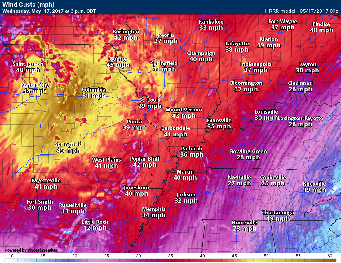
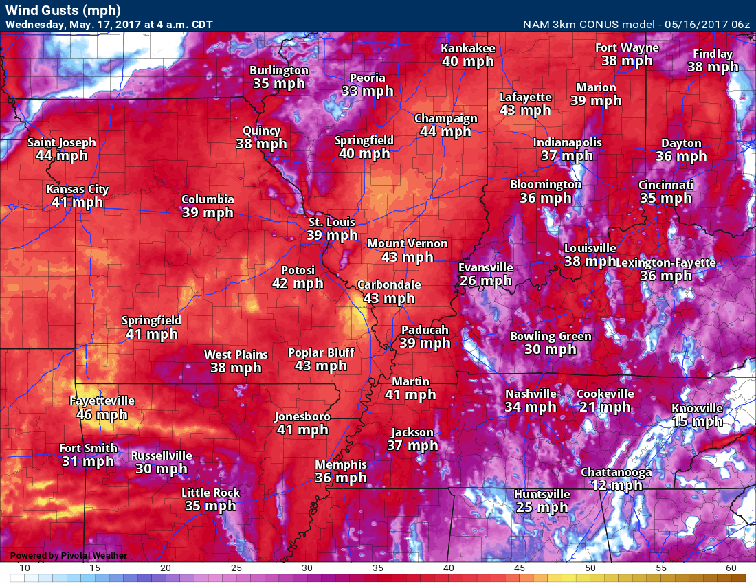
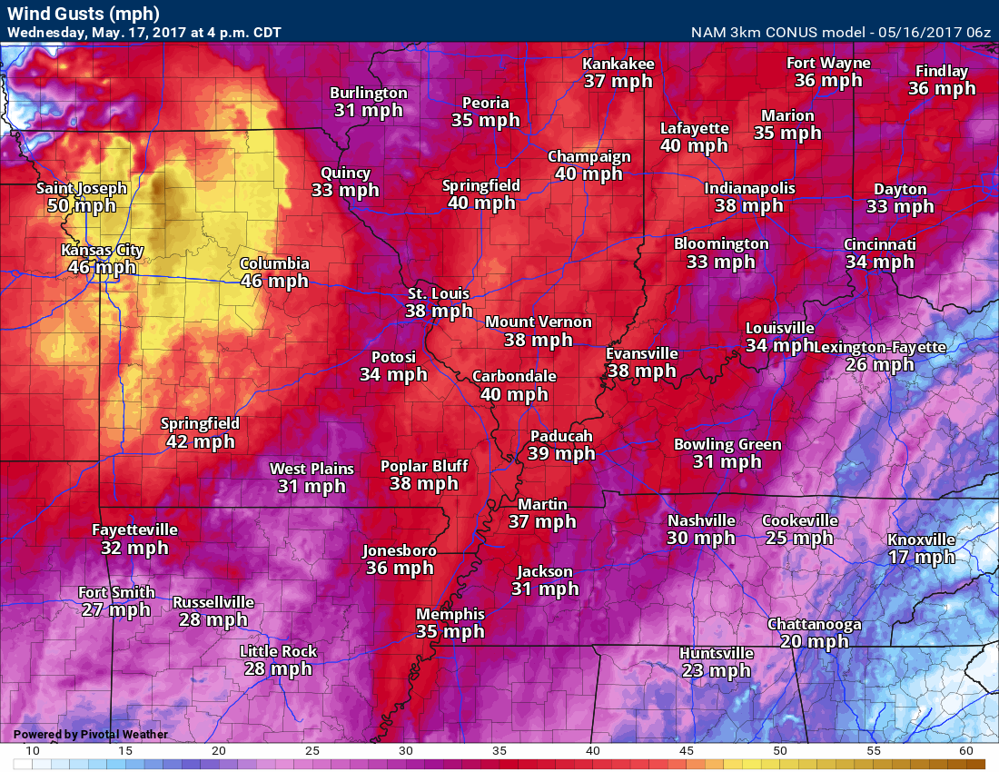
The big story over the next 24 hours will be gusty winds. Winds on Tuesday night could top 30 mph. Winds on Wednesday could top 45 mph. Anyone with lake or river plans should monitor wind conditions. These winds could also cause power outages in a few areas.
4 am Wednesday wind gust forecast map.
Click any of these images to enlarge.
Here is the Wednesday afternoon wind gust map
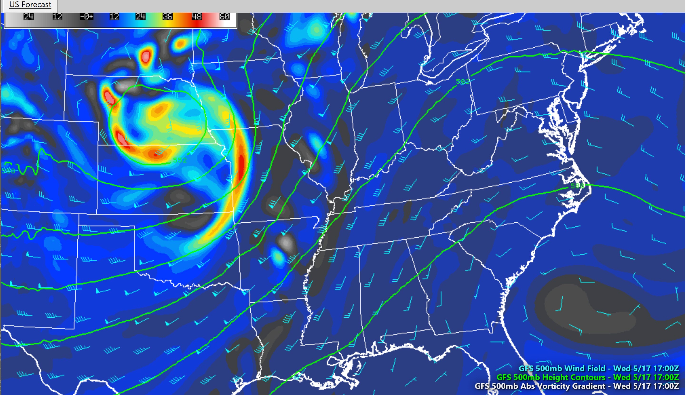
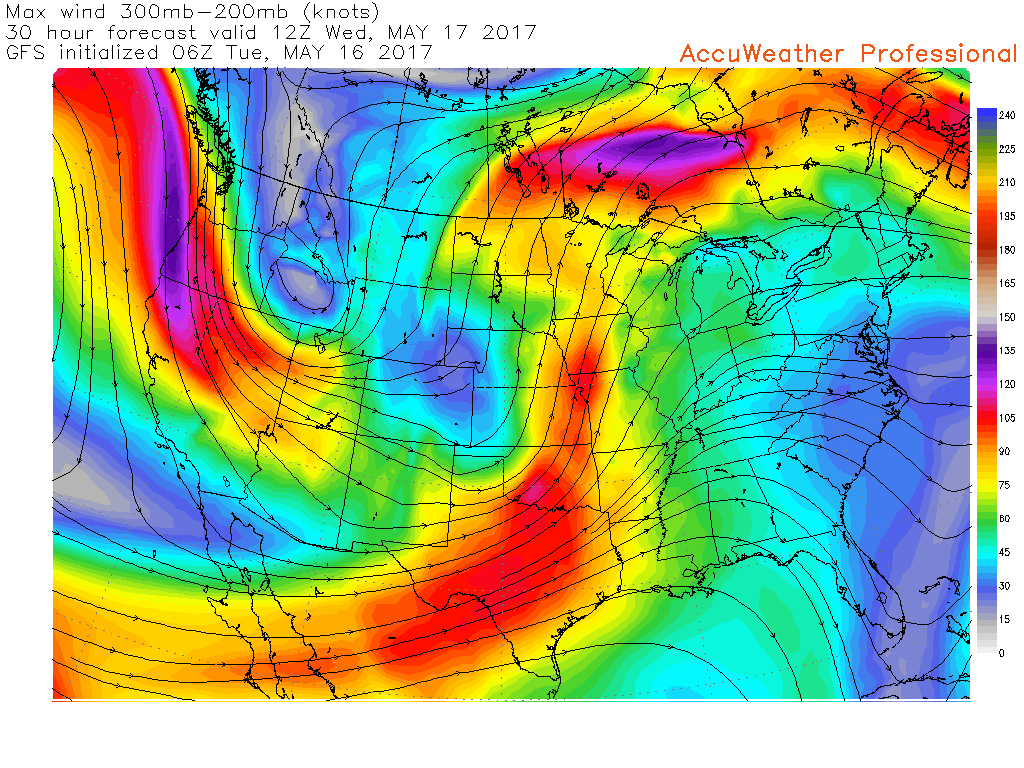
A series of upper level disturbances will move through our region over the coming five day period. Perhaps the strongest portion of the disturbances will remain a bit north and west of our local area.
You can see one of these disturbances on the 500 mb vorticity map. Those brighter colors well to our north and west represent the strongest portion of the lift. This is for Tuesday and Wednesday. Potent system.
With that said, enough energy will pass overhead to include at least a chance for showers and thunderstorms Wednesday afternoon (southeast Missouri and southwest Illinois) through Sunday.
There will be a couple of time periods when chances for rain and storms will peak. One of those will likely be on Friday and another Saturday/Sunday.
For the day by day breakdown of numbers, scroll back up to the top of the page. I did my best on the % numbers. Adjustments are likely.
A cold front will move through the region Saturday night and on Sunday. The timing of the front is key to when the best chances for rain will arrive. Lower than normal confidence on the exact timing of frontal passage.
Right now, it appears the best chance for frontal passage will be Saturday night into Sunday morning. Showers and thunderstorms, some locally heavy, will occur along the front. Once the front exits the region our rain chances will diminish.
If you have outdoor plans over the coming days, then make sure you check radars and updated forecast numbers. Don’t walk away with just one glance of the forecast.
Another storm system will bring precipitation chances to our region on Tuesday night into Wednesday.
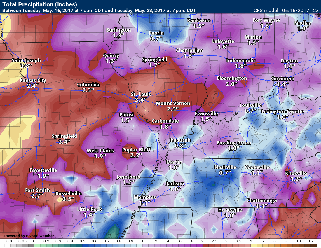
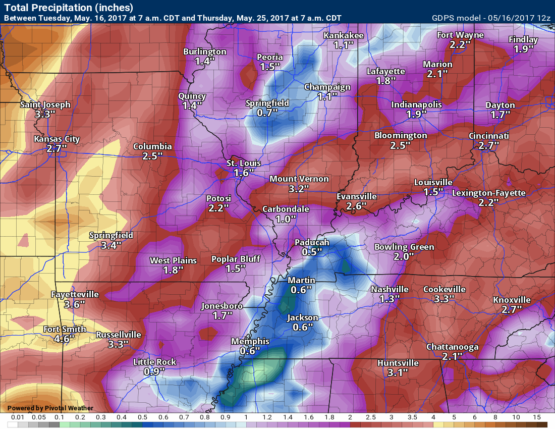
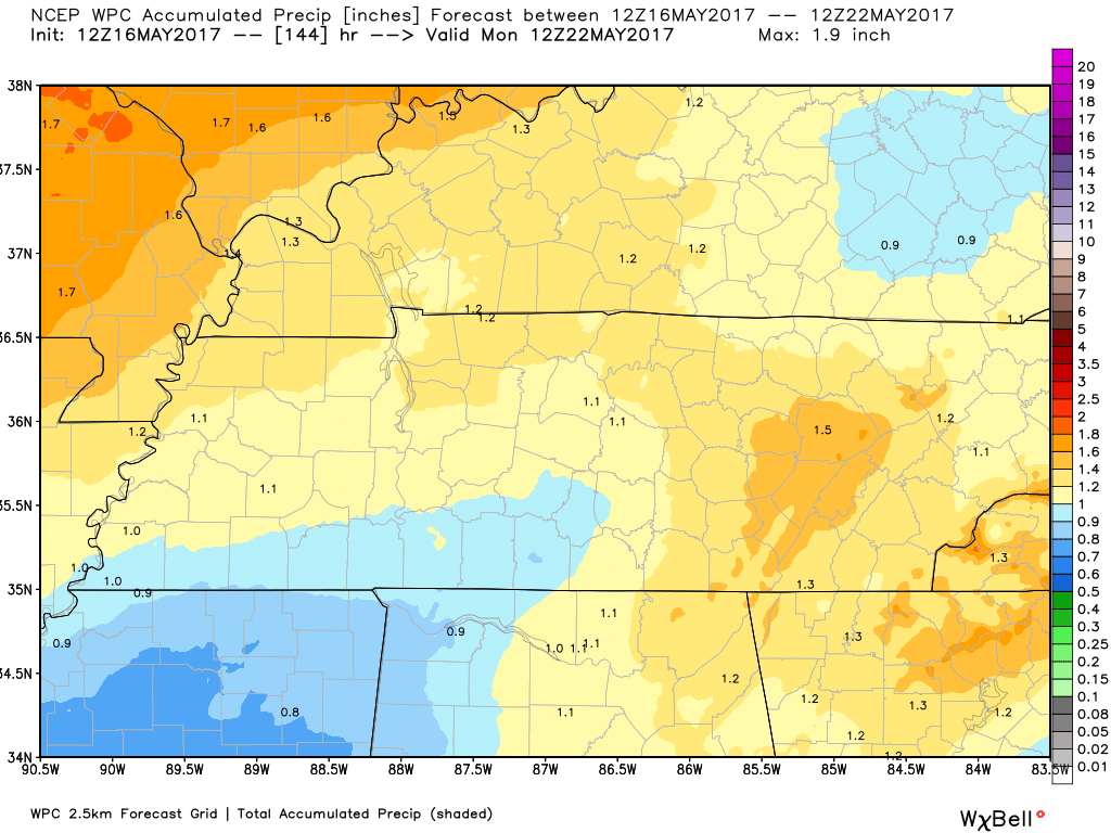
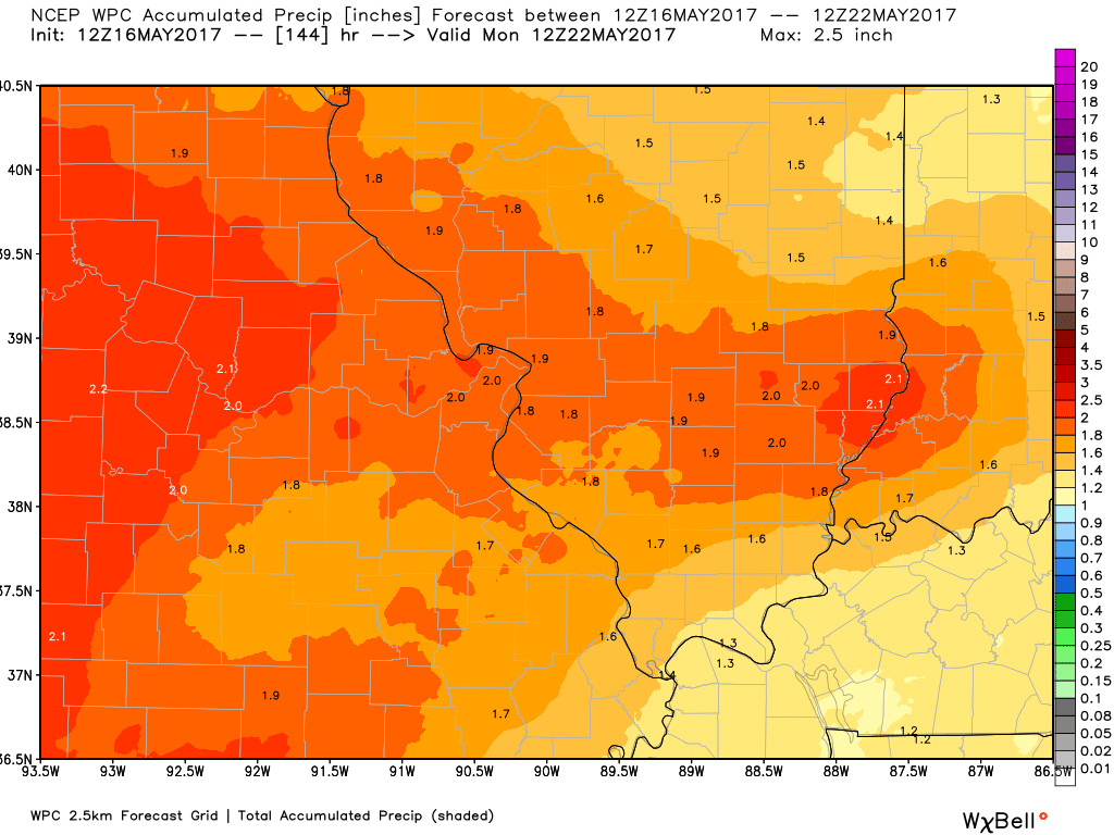
Rainfall totals between now and Sunday will likely range from 0.50″ to 1.00″. Slow moving or training thunderstorms could easily double or triple those numbers. It is that time of the year.
Let’s look at a couple of rainfall forecast maps. These are models. Models are for guidance and not gospel. These numbers won’t be exact, but you can get a feel for what the atmosphere might produce.
The GFS model
The GEM model
Let’s take a look at what the WPC/NOAA is forecasting for rainfall totals. This is now through Sunday.
Click image to enlarge
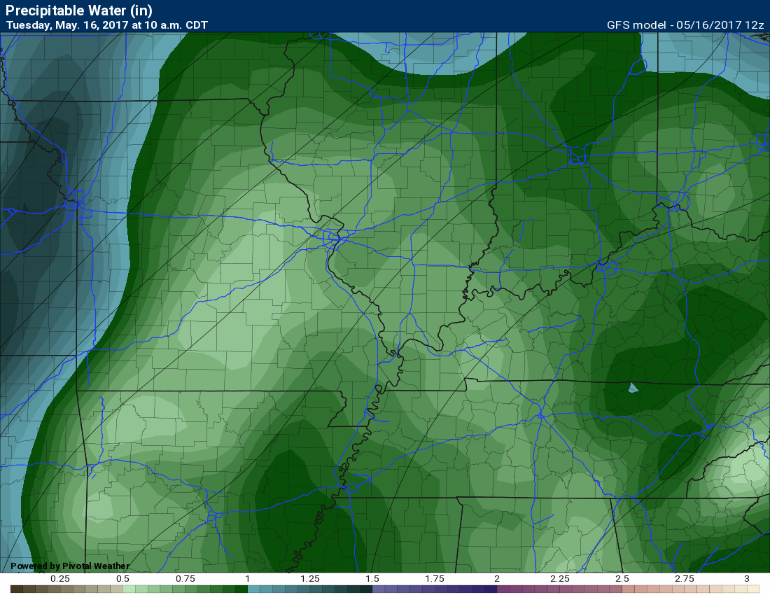
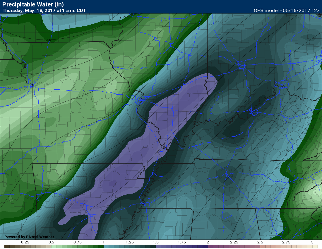
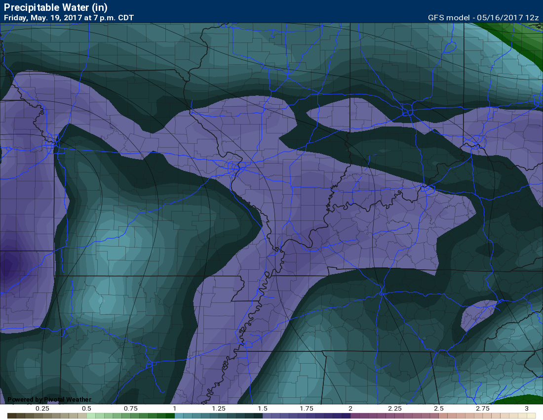
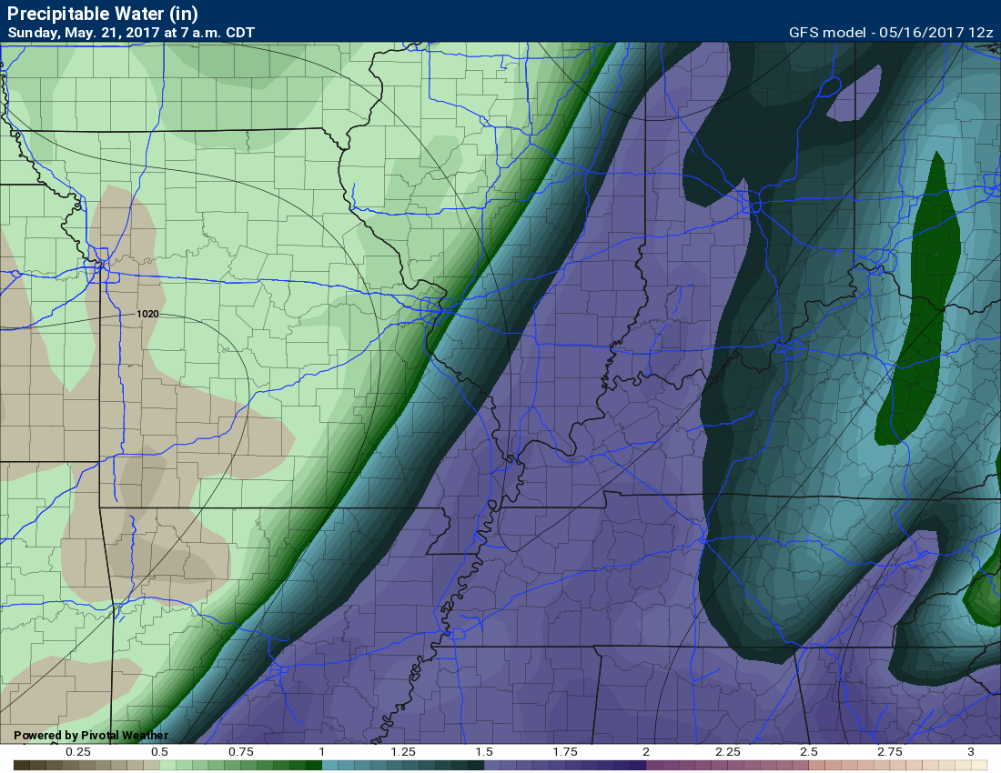
PWAT
PWAT is a measure of moisture in the entire atmosphere column. From the ground all the way up. The larger numbers are a signal for heavy rainfall.
Here is the Tuesday image. Notice our colors are not all that impressive.
Thursday at 1 am. Notice the sharp increase in colors. Purple equals high PWAT values. Any storms that form in this atmosphere would produce heavy downpours.
Friday’s PWAT values at 7 pm.
Sunday, May 21st. PWAT values ahead of the cold front. Notice how the higher numbers pool ahead of the cold front. Again, locally heavy rain.
It appears a northwest flow will develop next week. That is when the jet stream dives in from the northwest. Typically that is an active pattern signal in the spring and summer months. Disturbances often times will move along the jet stream flow. Each disturbance poses a chance for showers and thunderstorms.
Here is the 500 mb map for next week. Notice how the wind is coming from the northwest?
This is the jet stream for Tuesday/Wednesday. Notice how the upper level winds come out of the southwest and spread into our region? That is southwest flow.
Let’s move ahead
This is next Tuesday. Notice how the wind is more out of the west/northwest. Perhaps northwest flow developing.
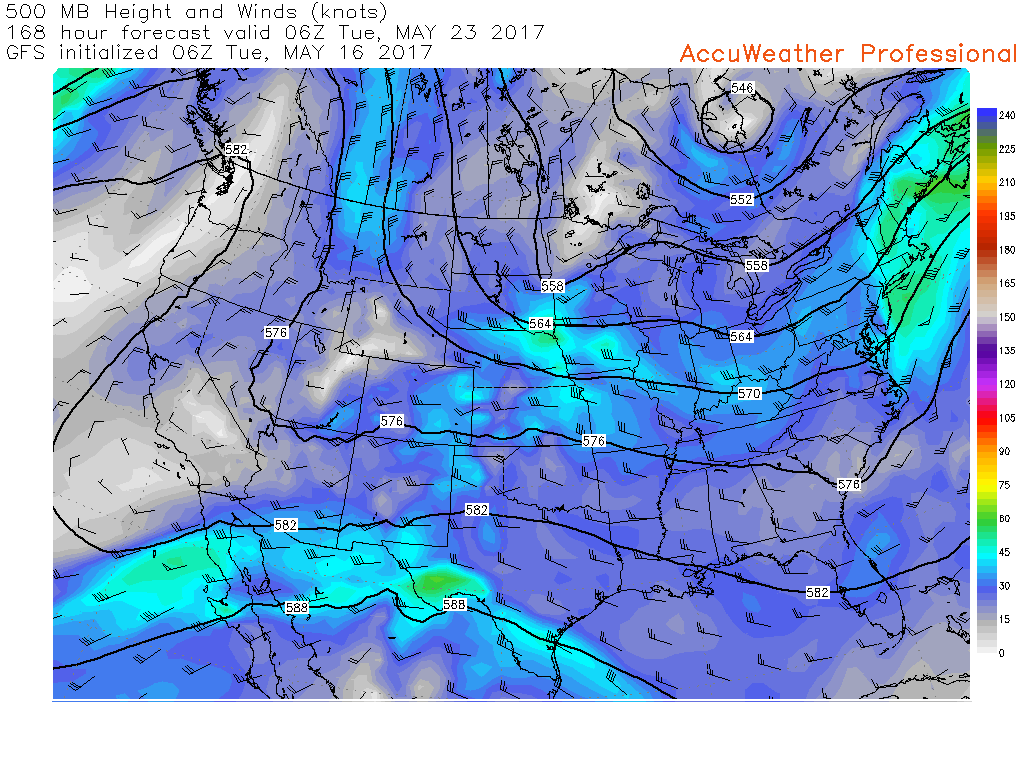
Those colors represent a disturbance stretched from northwest to southeast. Elongated. It is not uncommon for little disturbances to quickly move through this type of wind flow.


Find me on Twitter
.

We have regional radars and local city radars – if a radar does not update then try another one. Occasional browsers need their cache cleared. You may also try restarting your browser. That usually fixes the problem. Occasionally we do have a radar go down. That is why I have duplicates. Thus, if one fails then try another one.
During the winter you can track snow and ice by clicking the winterize button on the local city view interactive radars.
If you have any problems then please send me an email beaudodson@usawx.com
Interactive Weather Radar Page. Choose the city nearest your location: Click this link—
National interactive radar: Click this link.
Local interactive city radars include St Louis, Mt Vernon, Evansville, Poplar Bluff, Cape Girardeau, Marion, Paducah, Hopkinsville, Memphis, Nashville, Dyersburg, and all of eastern Kentucky. These are interactive radars. Local city radars – click here
.

The official 6-10 day and 8-14 day temperature and precipitation outlook. Check the date stamp at the top of each image (so you understand the time frame).
.
The forecast maps below are issued by the Weather Prediction Center (NOAA)
.

.

.
The latest 8-14 day temperature and precipitation outlook. Note the dates are at the top of the image. These maps DO NOT tell you how high or low temperatures or precipitation will be. They simply give you the probability as to whether temperatures or precipitation will be above or below normal.
.


.
The Beau Dodson Weather APP is ready for Apple and Android users. The purpose of this app is for me to deliver your text messages instantly. ATT and Verizon have not always been reliable when it comes to speed. The app allows instant delivery.
Some of you have asked if you can keep receiving the texts on your phone and the app. The answer to that is, yes. The Android app will automatically allow that to happen. On the Apple app, however, you will need to go into your app and click settings. Make sure the green tab is OFF. Off means you will still receive the texts to your phone and the app. If you have any questions, then email me at beaudodson@usawx.com
The app is for text subscribers.
The direct download, for the Apple app, can be viewed here
https://itunes.apple.com/us/app/id1190136514
If you have not signed up for the texting service then you may do so at www.beaudodsonweather.com

The Android app is also ready.
Remember, the app’s are for www.weathertalk.com subscribers. The app allows your to receive the text messages faster than ATT and Verizon.
Here is the download link for the Android version Click Here

——————————————————–
If you have not signed up for the texts messages, then please do. Link www.beaudodsonweather.com
Your support helps with the following:

and


Who do you trust for your weather information and who holds them accountable?
I have studied weather in our region since the late 1970’s. I have 39 years of experience in observing our regions weather patterns. My degree is in Broadcast Meteorology and a Bachelor’s of Science.
My resume includes:
Member of the American Meteorological Society.
NOAA Weather-Ready Nation Ambassador.
Meteorologist for McCracken County Emergency Management. I served from 2005 through 2015.
Meteorologist for McCracken County Rescue. 2015 through current
I own and operate the Southern Illinois Weather Observatory.
I am the chief meteorologist for Weather Talk LLC. I am the owner of Weather Talk LLC.
I am also a business owner in western Kentucky.
Recipient of the Mark Trail Award, WPSD Six Who Make A Difference Award, Kentucky Colonel, and the Caesar J. Fiamma” Award from the American Red Cross.
In 2005 I helped open the largest American Cross shelter in U.S. history in Houston, Texas. I was deployed to help after Hurricane Katrina and Hurricane Rita. I was a shelter manager of one of the Houston, Texas shelter divisions.
In 2009 I was presented with the Kentucky Office of Highway Safety Award.
Recognized by the Kentucky House of Representatives for my service to the State of Kentucky leading up to several winter storms and severe weather outbreaks.
If you click on the image below you can read the Kentucky House of Representatives Resolution.

I am also President of the Shadow Angel Foundation which serves portions of western Kentucky and southern Illinois.
There is a lot of noise on the internet. A lot of weather maps are posted without explanation. Over time you should learn who to trust for your weather information.
My forecast philosophy is simple and straight forward.
- Communicate in simple terms
- To be as accurate as possible within a reasonable time frame before an event
- Interact with you on Twitter, Facebook, email, texts, and this blog
- Minimize the “hype” that you might see on some television stations or through other weather sources
- Push you towards utilizing wall-to-wall LOCAL TV coverage during severe weather events
Many of the graphics on this page are from www.weatherbell.com
WeatherBell is a great resource for weather model guidance.


You can sign up for my AWARE email by clicking here I typically send out AWARE emails before severe weather, winter storms, or other active weather situations. I do not email watches or warnings. The emails are a basic “heads up” concerning incoming weather conditions