
.

This forecast update covers far southern Illinois, far southeast Missouri, and far western Kentucky. See the coverage map on the right side of the blog
Friday Night Forecast Details:
Forecast: Evening clouds. Showers ending. Cooler. Clearing overnight. Patchy dense fog possible.
Temperatures: MO ~ 46 to 52 IL ~ 46 to 52 KY ~ 48 to 54 TN ~ 48 to 54
Winds: North and northeast at 4 to 8 mph
My confidence in the forecast verifying: Medium. Some adjustments are possible.
What impacts are anticipated from the weather? Wet roadways early. Fog could reduce visibility.
Is severe weather expected? No
The NWS defines severe weather as 58 mph winds or great, 1″ hail or larger, and/or tornadoes
What is the chance of precipitation? MO ~ 40% IL ~ 40% KY ~ 50% TN ~ 50%
Coverage of precipitation: Scattered, but ending from west to east.
Should I cancel my outdoor plans? Monitor radars
.
May 13, 2017
Saturday Forecast Details
Forecast: Morning fog. Partly cloudy becoming mostly sunny. Mild.
Temperatures: MO ~ 74 to 77 IL 74 to 77 KY 74 to 77 TN 74 to 77
Winds: North winds at 5 to 10 mph. Winds becoming variable in direction.
What impacts are anticipated from the weather? Low visibility in fog.
My confidence in the forecast verifying: High. This forecast should verify.
Is severe weather expected? No
The NWS defines severe weather as 58 mph winds or great, 1″ hail or larger, and/or tornadoes
What is the chance of precipitation? MO ~ 0% IL ~ 0% KY ~ 0% TN ~ 0%
Coverage of precipitation: None
Should I cancel my outdoor plans? No
.
Saturday Night Forecast Details:
Forecast: Mostly clear. Cool.
Temperatures: MO ~ 48 to 54 IL ~ 50 to 55 KY ~ 50 to 55 TN ~ 52 to 56
Winds: north and northeast wind at 4 to 8 mph.
My confidence in the forecast verifying: High. This forecast should verify.
What impacts are anticipated from the weather? None
Is severe weather expected? No
The NWS defines severe weather as 58 mph winds or great, 1″ hail or larger, and/or tornadoes
What is the chance of precipitation? MO ~ 0% IL ~ 0% KY ~ 0% TN ~ 0%
Coverage of precipitation: None
Should I cancel my outdoor plans? No
.
May 14, 2017
Sunday Forecast Details
Forecast: Partly to mostly sunny. Warmer.
Temperatures: MO ~ 76 to 84 IL 76 to 84 KY 76 to 84 TN 76 to 84
Winds: South and southwest winds at 5 to 10 mph with gusts to 12 mph.
What impacts are anticipated from the weather? None
My confidence in the forecast verifying: High. This forecast should verify.
Is severe weather expected? No
The NWS defines severe weather as 58 mph winds or great, 1″ hail or larger, and/or tornadoes
What is the chance of precipitation? MO ~ 0% IL ~ 0% KY ~ 0% TN ~ 0%
Coverage of precipitation: None
Should I cancel my outdoor plans? No
.
Sunday Night Forecast Details:
Forecast: Mostly clear.
Temperatures: MO ~ 55 to 60 IL ~ 55 to 60 KY ~ 55 to 60 TN ~ 55 to 60
Winds: South and southwest winds at 3 to 6 mph
My confidence in the forecast verifying: High. This forecast should verify.
What impacts are anticipated from the weather? None
Is severe weather expected? No
The NWS defines severe weather as 58 mph winds or great, 1″ hail or larger, and/or tornadoes
What is the chance of precipitation? MO ~ 0% IL ~ 0% KY ~ 0% TN ~ 0%
Coverage of precipitation: None
Should I cancel my outdoor plans? No
.
May 15, 2017
Monday Forecast Details
Forecast: Mostly sunny. Quite warm.
Temperatures: MO ~ 82 to 86 IL 82 to 86 KY 82 to 86 TN 82 to 86
Winds: South and southwest at 6 to 12 mph with gusts to 15 mph
What impacts are anticipated from the weather? None
My confidence in the forecast verifying: High. This forecast should verify.
Is severe weather expected? No
The NWS defines severe weather as 58 mph winds or great, 1″ hail or larger, and/or tornadoes
What is the chance of precipitation? MO ~ 0% IL ~ 0% KY ~ 0% TN ~ 0%
Coverage of precipitation: None
Should I cancel my outdoor plans? No
.
Monday Night Forecast Details:
Forecast: Mostly clear. Mild.
Temperatures: MO ~ 58 to 64 IL ~ 58 to 64 KY ~ 58 to 64 TN ~ 58 to 64
Winds: South and southwest at 5 mph
My confidence in the forecast verifying: Medium. Some adjustments are possible.
What impacts are anticipated from the weather? None
Is severe weather expected? No
The NWS defines severe weather as 58 mph winds or great, 1″ hail or larger, and/or tornadoes
What is the chance of precipitation? MO ~ 0% IL ~ 0% KY ~ 0% TN ~ 0%
Coverage of precipitation: None
Should I cancel my outdoor plans? No
.
May 16, 2017
Tuesday Forecast Details
Forecast: Mostly sunny. Warm.
Temperatures: MO ~ 82 to 86 IL 82 to 86 KY 82 to 86 TN 82 to 86
Winds: South and southwest at 6 to 12 mph with gusts to 15 mph
What impacts are anticipated from the weather? None
My confidence in the forecast verifying: High. This forecast should verify.
Is severe weather expected? No
The NWS defines severe weather as 58 mph winds or great, 1″ hail or larger, and/or tornadoes
What is the chance of precipitation? MO ~ 10% IL ~ 0% KY ~ 0% TN ~ 0%
Coverage of precipitation: None
Should I cancel my outdoor plans? No
.
Tuesday Night Forecast Details:
Forecast: Partly cloudy.
Temperatures: MO ~ 62 to 66 IL ~ 62 to 66 KY ~ 62 to 66 TN ~ 62 to 66
Winds: South and southwest at 5 mph with gusts to 10 mph.
My confidence in the forecast verifying: Medium. Some adjustments are possible.
What impacts are anticipated from the weather? None
Is severe weather expected? No
The NWS defines severe weather as 58 mph winds or great, 1″ hail or larger, and/or tornadoes
What is the chance of precipitation? MO ~ 10% IL ~ 10% KY ~ 0% TN ~ 0%
Coverage of precipitation: None
Should I cancel my outdoor plans? No
.
May 17, 2017
Wednesday Forecast Details
Forecast: Partly sunny. Warm. Well above normal temperatures.
Temperatures: MO ~ 80 to 85 IL 80 to 85 KY 80 to 85 TN 80 to 85
Winds: South and southwest at 8 to 16 mph with gusts to 20 mph
What impacts are anticipated from the weather? Wet roadways. Lightning.
My confidence in the forecast verifying: Low. Significant adjustments are possible.
Is severe weather expected? No
The NWS defines severe weather as 58 mph winds or great, 1″ hail or larger, and/or tornadoes
What is the chance of precipitation? MO ~ 20% IL ~ 20% KY ~ 20% TN ~ 20%
Coverage of precipitation: None to isolated.
Should I cancel my outdoor plans? No
.
Wednesday Night Forecast Details:
Forecast: Cloudy. A chance for showers and thunderstorms.
Temperatures: MO ~ 62 to 66 IL ~ 62 to 66 KY ~ 62 to 66 TN ~ 62 to 66
Winds: South and southwest at 5 mph with gusts to 15 mph.
My confidence in the forecast verifying: Low. Significant adjustments are possible.
What impacts are anticipated from the weather? Wet roadways. Lightning.
Is severe weather expected? Monitor updates.
The NWS defines severe weather as 58 mph winds or great, 1″ hail or larger, and/or tornadoes
What is the chance of precipitation? MO ~ 40% IL ~ 40% KY ~ 40% TN ~ 40%
Coverage of precipitation: Scattered
Should I cancel my outdoor plans? No, but monitor updated forecasts.
.
May 18, 2017
Thursday Forecast Details
Forecast: Partly cloudy. A 50% for showers and thunderstorms. Warm.
Temperatures: MO ~ 80 to 85 IL 80 to 85 KY 80 to 85 TN 80 to 85
Winds: South and southwest at 7 to 14 mph. Gusty
What impacts are anticipated from the weather? Wet roadways. Lightning.
My confidence in the forecast verifying: Low. Significant adjustments are possible.
Is severe weather expected? Monitor updates
The NWS defines severe weather as 58 mph winds or great, 1″ hail or larger, and/or tornadoes
What is the chance of precipitation? MO ~ 50% IL ~ 50% KY ~ 50% TN ~ 50%
Coverage of precipitation: Scattered
Should I cancel my outdoor plans? Monitor updates
.
Thursday Night Forecast Details:
Forecast: Partly cloudy. A 50% for showers and thunderstorms.
Temperatures: MO ~ 62 to 66 IL ~ 62 to 66 KY ~ 62 to 66 TN ~ 62 to 66
Winds: South and southwest at 6 to 12 mph
My confidence in the forecast verifying: Low. Significant adjustments are possible.
What impacts are anticipated from the weather? Wet roadways. Lightning.
Is severe weather expected? Monitor updates
The NWS defines severe weather as 58 mph winds or great, 1″ hail or larger, and/or tornadoes
What is the chance of precipitation? MO ~ 50% IL ~ 50% KY ~ 50% TN ~ 50%
Coverage of precipitation: Scattered
Should I cancel my outdoor plans? Monitor updates
.
May 19, 2017
Friday Forecast Details
Forecast: Partly cloudy. Warm. A 30% chance for showers and thunderstorms.
Temperatures: MO ~ 80 to 85 IL 80 to 85 KY 80 to 85 TN 80 to 85
Winds: South and southwest at 6 ti 12 mph
What impacts are anticipated from the weather? Wet roadways and lightning.
My confidence in the forecast verifying: Low. Significant adjustments are possible.
Is severe weather expected? Monitor updates
The NWS defines severe weather as 58 mph winds or great, 1″ hail or larger, and/or tornadoes
What is the chance of precipitation? MO ~ 30% IL ~ 30% KY ~ 30% TN ~ 30%
Coverage of precipitation: Scattered
Should I cancel my outdoor plans? Monitor updates
.
Friday Night Forecast Details:
Forecast: Partly cloudy. A 30% for thunderstorms.
Temperatures: MO ~ 62 to 66 IL ~ 62 to 66 KY ~ 62 to 66 TN ~ 62 to 66
Winds: South and southwest at 5 to 10 mph
My confidence in the forecast verifying: Low. Significant adjustments are possible.
What impacts are anticipated from the weather? Wet roadways. Lightning.
Is severe weather expected? Monitor updates
The NWS defines severe weather as 58 mph winds or great, 1″ hail or larger, and/or tornadoes
What is the chance of precipitation? MO ~ 30% IL ~ 30% KY ~ 30% TN ~ 30%
Coverage of precipitation: Scattered
Should I cancel my outdoor plans? Monitor updates
.
May 20, 2017
Saturday Forecast Details
Forecast: Partly cloudy. A 30% for showers and thunderstorms.
Temperatures: MO ~ 80 to 85 IL 80 to 85 KY 80 to 85 TN 80 to 85
Winds: South and southwest at 6 to 12 mph
What impacts are anticipated from the weather? Lightning. Wet roadways
My confidence in the forecast verifying: Low. Significant adjustments are possible.
Is severe weather expected? Monitor updates
The NWS defines severe weather as 58 mph winds or great, 1″ hail or larger, and/or tornadoes
What is the chance of precipitation? MO ~ 30% IL ~ 30% KY ~ 30% TN ~ 30%
Coverage of precipitation: Scattered
Should I cancel my outdoor plans? Monitor updates
.
Saturday Night Forecast Details:
Forecast: Partly cloudy. A 30% for showers and thunderstorms.
Temperatures: MO ~ 65 to 70 IL ~ 65 to 70 KY ~ 65 to 70 TN ~ 65 to 70
Winds: South and southwest winds at 5 to 10 mph
My confidence in the forecast verifying: Low. Significant adjustments are possible.
What impacts are anticipated from the weather? Wet roadways. Lightning
Is severe weather expected? Monitor updates
The NWS defines severe weather as 58 mph winds or great, 1″ hail or larger, and/or tornadoes
What is the chance of precipitation? MO ~ 30% IL ~ 30% KY ~ 30% TN ~ 30%
Coverage of precipitation: Scattered
Should I cancel my outdoor plans? Monitor updates
.
May 21, 2017
Sunday Forecast Details
Forecast: Partly cloudy. A 30% chance for showers and thunderstorms. Warm.
Temperatures: MO ~ 76 to 82 IL 76 to 82 KY 76 to 82 TN 76 to 82
Winds: South and southwest at 6 to 12 mph
What impacts are anticipated from the weather? Wet roadways and lightning
My confidence in the forecast verifying: Low. Significant adjustments are possible.
Is severe weather expected? Monitor updates
The NWS defines severe weather as 58 mph winds or great, 1″ hail or larger, and/or tornadoes
What is the chance of precipitation? MO ~ 30% IL ~ 30% KY ~ 30% TN ~ 30%
Coverage of precipitation: Scattered
Should I cancel my outdoor plans? Monitor updates
.
Sunday Night Forecast Details:
Forecast: Partly cloudy. A 30% for showers and thunderstorms.
Temperatures: MO ~ 62 to 66 IL ~ 62 to 66 KY ~ 62 to 66 TN ~ 62 to 66
Winds: South and southwest at 5 to 10 mph
My confidence in the forecast verifying: Low. Significant adjustments are possible.
What impacts are anticipated from the weather? Wet roadways and lightning.
Is severe weather expected? Monitor updates
The NWS defines severe weather as 58 mph winds or great, 1″ hail or larger, and/or tornadoes
What is the chance of precipitation? MO ~ 30% IL ~ 30% KY ~ 30% TN ~ 30%
Coverage of precipitation: Scattered
Should I cancel my outdoor plans? Monitor updates
.
.
Don’t forget to check out the Southern Illinois Weather Observatory web-site for weather maps, tower cams, scanner feeds, radars, and much more! Click here

An explanation of what is happening in the atmosphere over the coming day

A severe thunderstorm is defined as a storm that produces quarter size hail or larger, 58 mph winds or greater, and/or a tornado. That is the official National Weather Service definition of a severe thunderstorm.
Friday into Tuesday: Severe weather is not anticipated. There is a small risk for lightning on Friday.
Weather Analysis for the coming week:
We still have rivers out of their banks across most of the region. Be sure and check out the latest lake and river stages. Here is the link to view those ~ River Stage Forecasts
Friday night through Sunday:
A nice weekend on tap for the region. Clouds may linger Friday evening, but should decrease through the night.
Nice on both Saturday and Sunday. High temperatures on Saturday will mostly be in the 70’s. Highs on Sunday may top 80 degrees!
Monday through Tuesday night: Severe weather is not anticipated
Wednesday through Sunday: There will be increasing chances for showers and thunderstorms towards the middle and end of next week. I can’t rule out severe weather. Monitor updates.
.
Weather Analysis for the coming week:
We still have rivers out of their banks across most of the region. Be sure and check out the latest lake and river stages. Here is the link to view those ~ River Stage Forecasts
Friday night:
Lingering clouds will exit the region. There will be a slight chance for remaining showers over the Pennyrile area of western Kentucky. Cool tonight. Patchy fog possible.
Saturday through Tuesday night:
Calm weather. A beautiful weekend is in store for the region. Expect mostly sunny sky conditions on Saturday and Sunday. Highs will reach into the 70’s on Saturday and perhaps some 80’s on Sunday.
Dry conditions. Winds will be in the 5 to 10 mph range with gusts to 12 mph.
The main weather story over the coming seven to ten days will be well above normal temperatures. Highs will top out in the 80’s from Sunday through at least next Wednesday. It is possible that the 80’s last into next weekend.
I can’t rule out someone hitting 90 degrees next week.
An unsettled pattern is showing up in the charts from Wednesday into next weekend. We will have on and off chances for showers and locally heavy thunderstorms. We will need to monitor the risk for severe weather. I suspect we see numerous days next week with the Storm Prediction Center outlining portions of the central United States. Some of those days may reach into our local area.
It is difficult, this far out, to know the exact percentage chance for rain next week. I blanketed much of the forecast with 30% numbers. Those will need adjusting.
Here is what the GFS model is showing
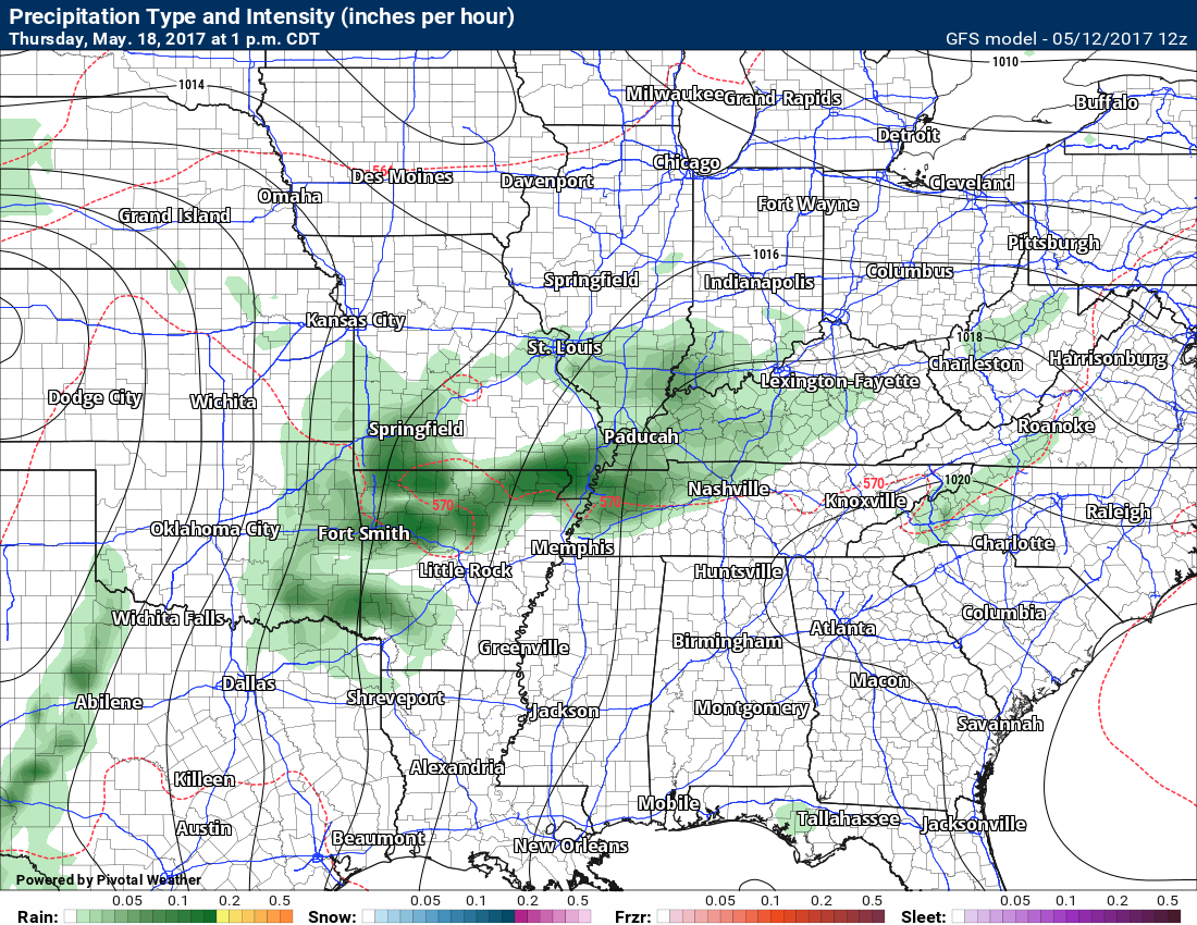
May 18, 2017: Thursday afternoon. You can see the GFS believes we will have some rain and storms.
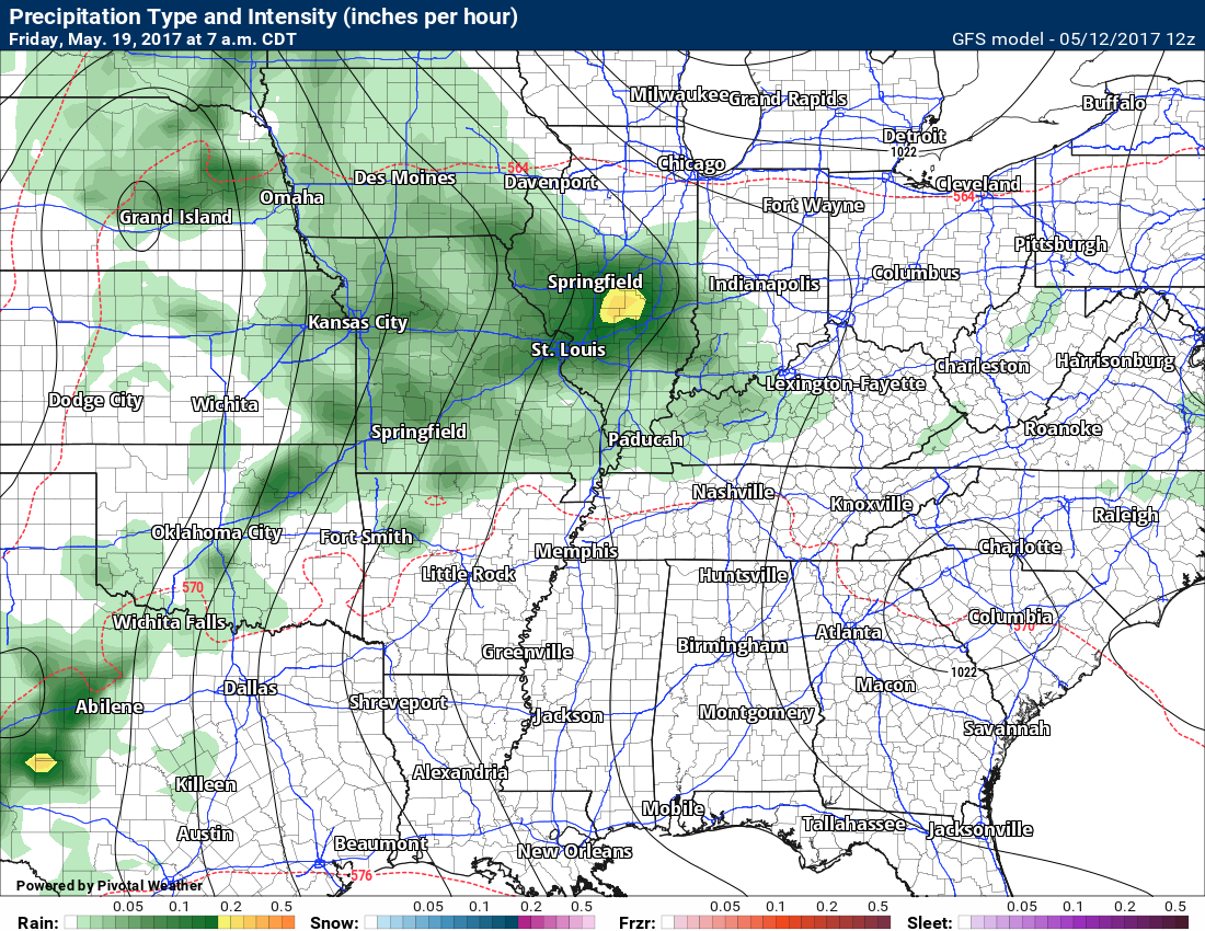
May 19, 2017: Friday GFS precipitation potential in green. Long way out, but you get the general idea.
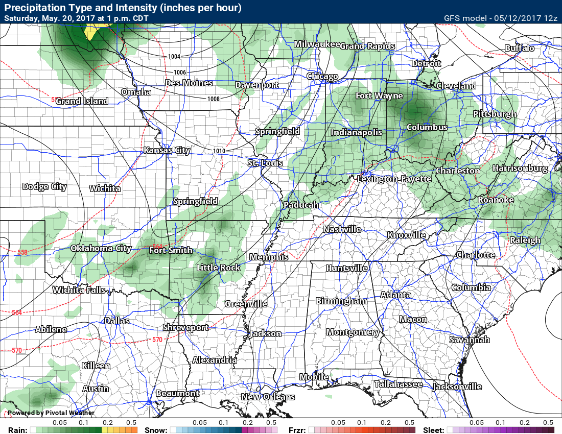
May 20, 2017: Saturday precipitation map from the GFS model.
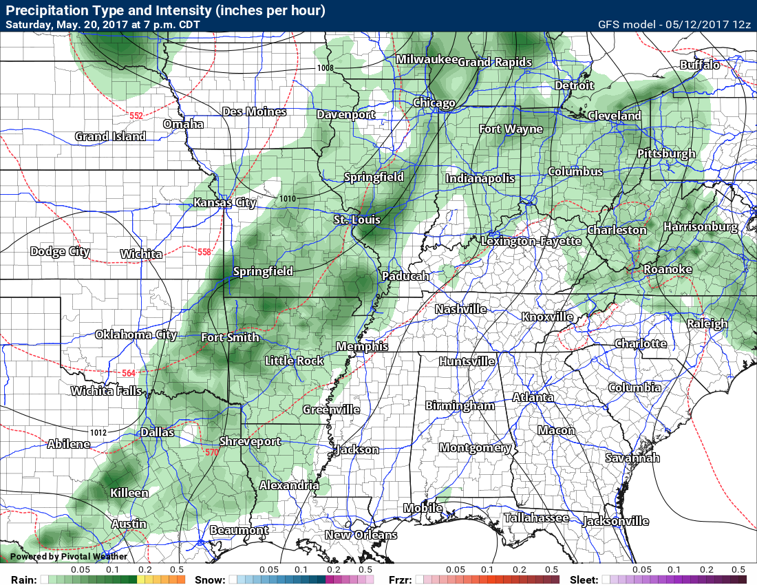
May 20, 2017: Saturday 7 pm future-cast precipitation potential
The jet stream winds next week indicates the potential for quite a bit of warm and moist air streaming northward from the Gulf of Mexico.
Notice how the lines move from the southwest U.S. into the central United States. Strong southwest flow. Divergence, as well.
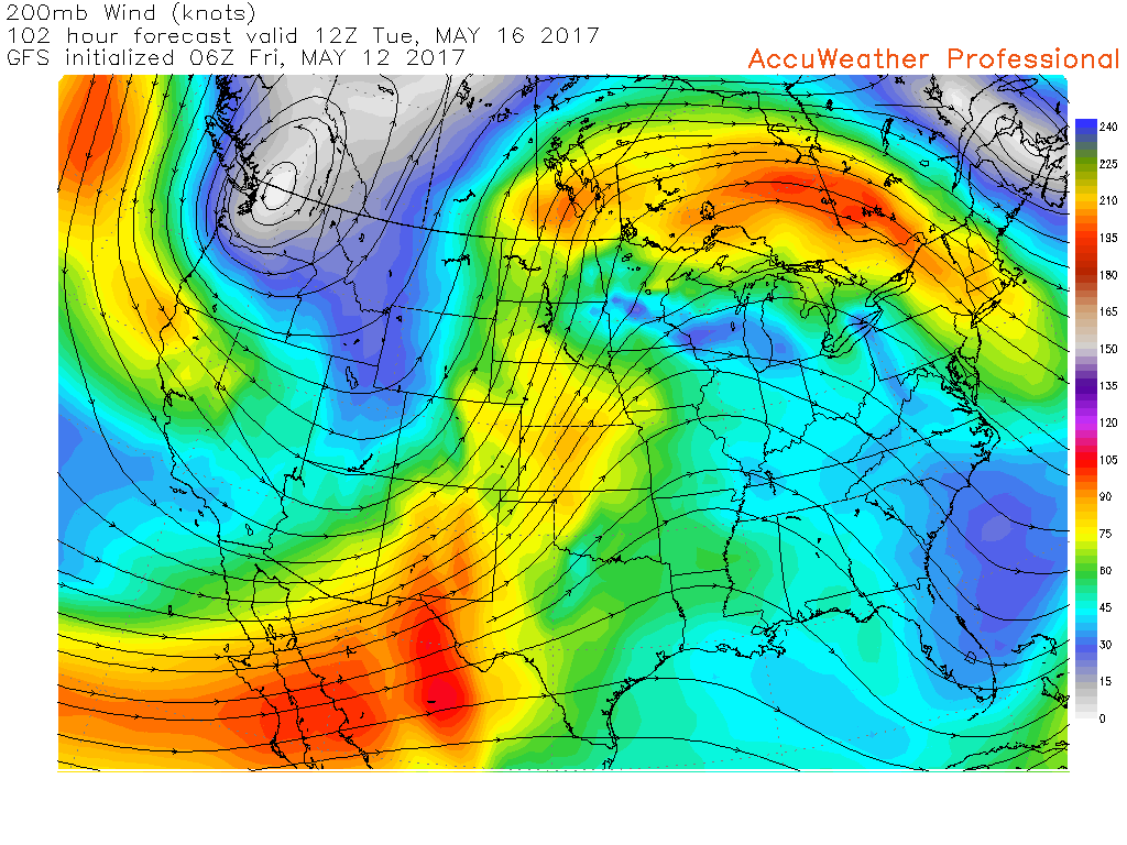
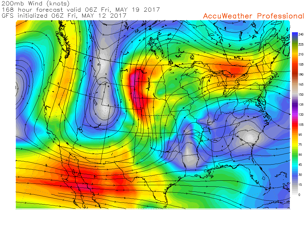
The Friday jet stream map indicates much of the same.
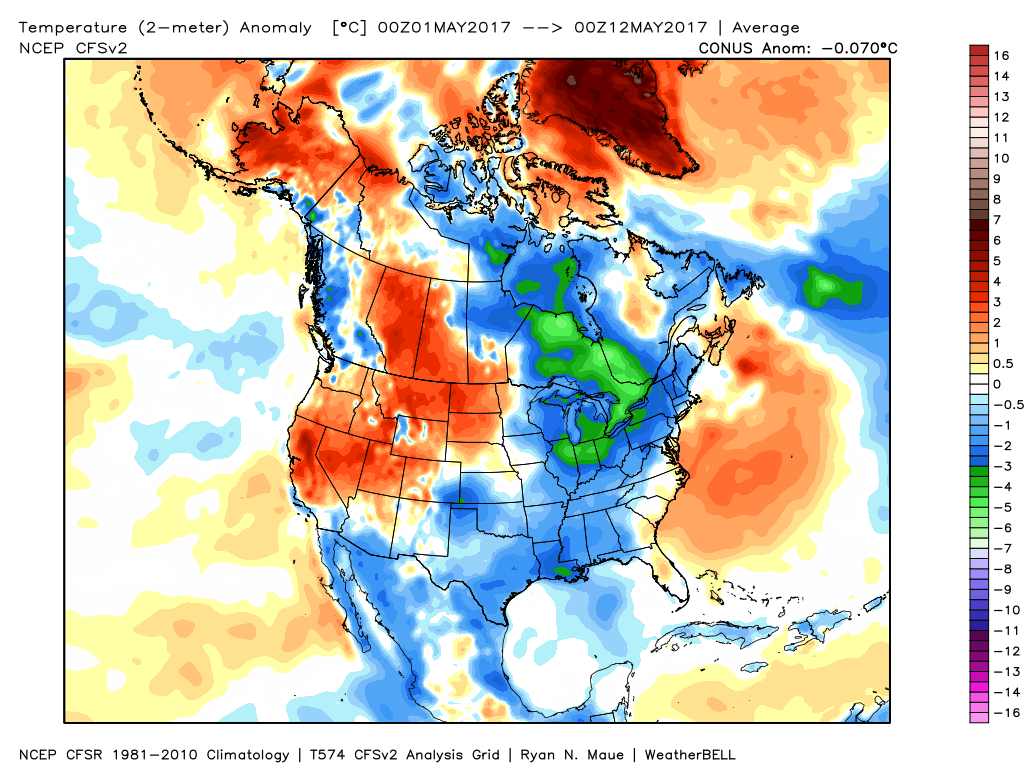
Temperatures so far this month have averaged below normal.
Here is the month to date temperature anomalies. Blue indicates below normal (averaged out).
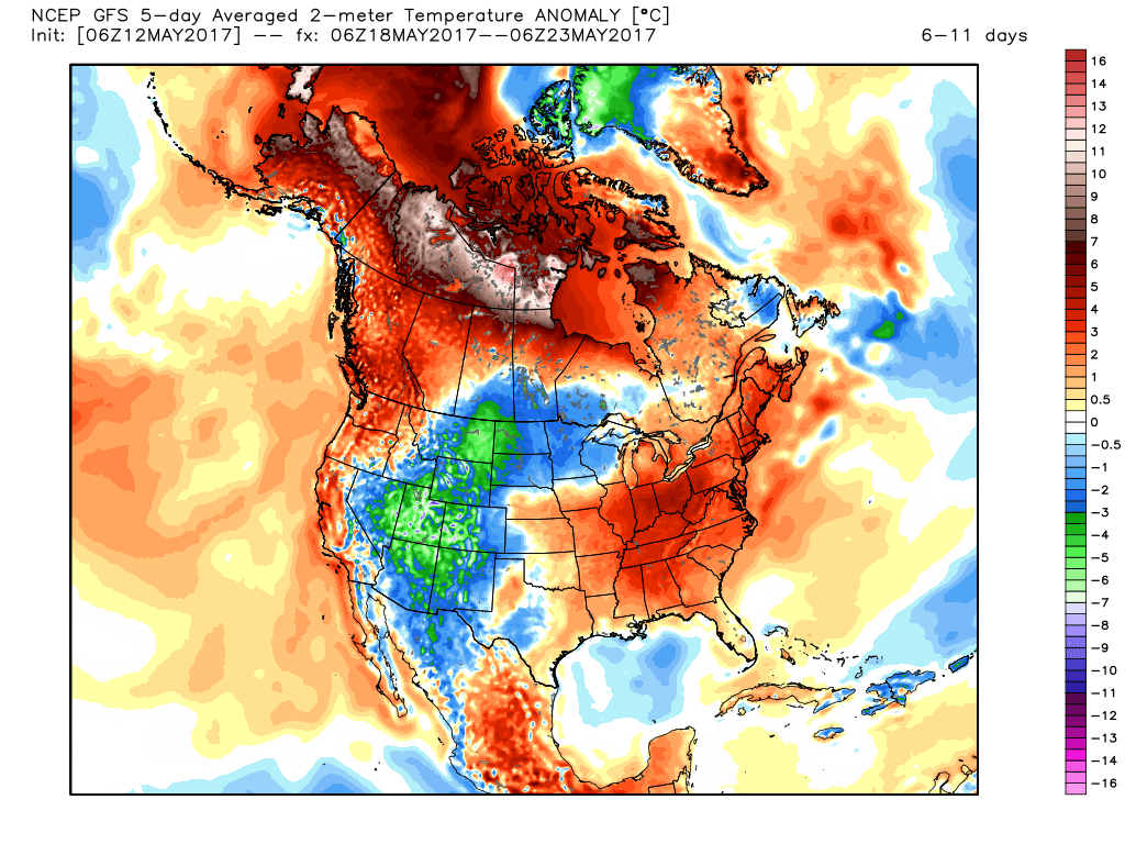
Look at the forecast five day temperature anomalies for next week. A flip? Appears that way (for temperatures, at least)
Long range may remain active into early June. The Missouri and Ohio Valley regions may become sick of rain. Not that they already aren’t.
Here is the 45 day rainfall forecast from one of the ensembles suites. Now, this isn’t going to verify exactly as you see it. We just take the general idea from the data. It is wet.
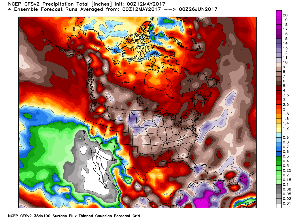
I do not like active weather at the end of May and June. It normally will mean severe weather and/or flash flooding. This is something we need to monitor. It is possible the bulls eyes for heaviest rains will end up somewhere in the Missouri Valley. Too soon to know.
Happy Mother’s Day to all of the mother’s among us!

Find me on Twitter

We have regional radars and local city radars – if a radar does not update then try another one. Occasional browsers need their cache cleared. You may also try restarting your browser. That usually fixes the problem. Occasionally we do have a radar go down. That is why I have duplicates. Thus, if one fails then try another one.
During the winter you can track snow and ice by clicking the winterize button on the local city view interactive radars.
If you have any problems then please send me an email beaudodson@usawx.com
Interactive Weather Radar Page. Choose the city nearest your location: Click this link—
National interactive radar: Click this link.
Local interactive city radars include St Louis, Mt Vernon, Evansville, Poplar Bluff, Cape Girardeau, Marion, Paducah, Hopkinsville, Memphis, Nashville, Dyersburg, and all of eastern Kentucky. These are interactive radars. Local city radars – click here
Regional Radar

The official 6-10 day and 8-14 day temperature and precipitation outlook. Check the date stamp at the top of each image (so you understand the time frame).
The forecast maps below are issued by the Weather Prediction Center (NOAA)


The latest 8-14 day temperature and precipitation outlook. Note the dates are at the top of the image. These maps DO NOT tell you how high or low temperatures or precipitation will be. They simply give you the probability as to whether temperatures or precipitation will be above or below normal.


The Beau Dodson Weather APP is ready for Apple and Android users. The purpose of this app is for me to deliver your text messages instantly. ATT and Verizon have not always been reliable when it comes to speed. The app allows instant delivery.
Some of you have asked if you can keep receiving the texts on your phone and the app. The answer to that is, yes. The Android app will automatically allow that to happen. On the Apple app, however, you will need to go into your app and click settings. Make sure the green tab is OFF. Off means you will still receive the texts to your phone and the app. If you have any questions, then email me at beaudodson@usawx.com
The app is for text subscribers.
The direct download, for the Apple app, can be viewed here
https://itunes.apple.com/us/app/id1190136514
If you have not signed up for the texting service then you may do so at www.beaudodsonweather.com

The Android app is also ready.
Remember, the app’s are for www.weathertalk.com subscribers. The app allows your to receive the text messages faster than ATT and Verizon.
Here is the download link for the Android version Click Here

——————————————————–
If you have not signed up for the texts messages, then please do. Link www.beaudodsonweather.com
Your support helps with the following:

and


Who do you trust for your weather information and who holds them accountable?
I have studied weather in our region since the late 1970’s. I have 39 years of experience in observing our regions weather patterns. My degree is in Broadcast Meteorology and a Bachelor’s of Science.
My resume includes:
Member of the American Meteorological Society.
NOAA Weather-Ready Nation Ambassador.
Meteorologist for McCracken County Emergency Management. I served from 2005 through 2015.
Meteorologist for McCracken County Rescue. 2015 through current
I own and operate the Southern Illinois Weather Observatory.
I am the chief meteorologist for Weather Talk LLC. I am the owner of Weather Talk LLC.
I am also a business owner in western Kentucky.
Recipient of the Mark Trail Award, WPSD Six Who Make A Difference Award, Kentucky Colonel, and the Caesar J. Fiamma” Award from the American Red Cross.
In 2005 I helped open the largest American Cross shelter in U.S. history in Houston, Texas. I was deployed to help after Hurricane Katrina and Hurricane Rita. I was a shelter manager of one of the Houston, Texas shelter divisions.
In 2009 I was presented with the Kentucky Office of Highway Safety Award.
Recognized by the Kentucky House of Representatives for my service to the State of Kentucky leading up to several winter storms and severe weather outbreaks.
If you click on the image below you can read the Kentucky House of Representatives Resolution.

I am also President of the Shadow Angel Foundation which serves portions of western Kentucky and southern Illinois.
There is a lot of noise on the internet. A lot of weather maps are posted without explanation. Over time you should learn who to trust for your weather information.
My forecast philosophy is simple and straight forward.
- Communicate in simple terms
- To be as accurate as possible within a reasonable time frame before an event
- Interact with you on Twitter, Facebook, email, texts, and this blog
- Minimize the “hype” that you might see on some television stations or through other weather sources
- Push you towards utilizing wall-to-wall LOCAL TV coverage during severe weather events
Many of the graphics on this page are from www.weatherbell.com
WeatherBell is a great resource for weather model guidance.


You can sign up for my AWARE email by clicking here I typically send out AWARE emails before severe weather, winter storms, or other active weather situations. I do not email watches or warnings. The emails are a basic “heads up” concerning incoming weather conditions