
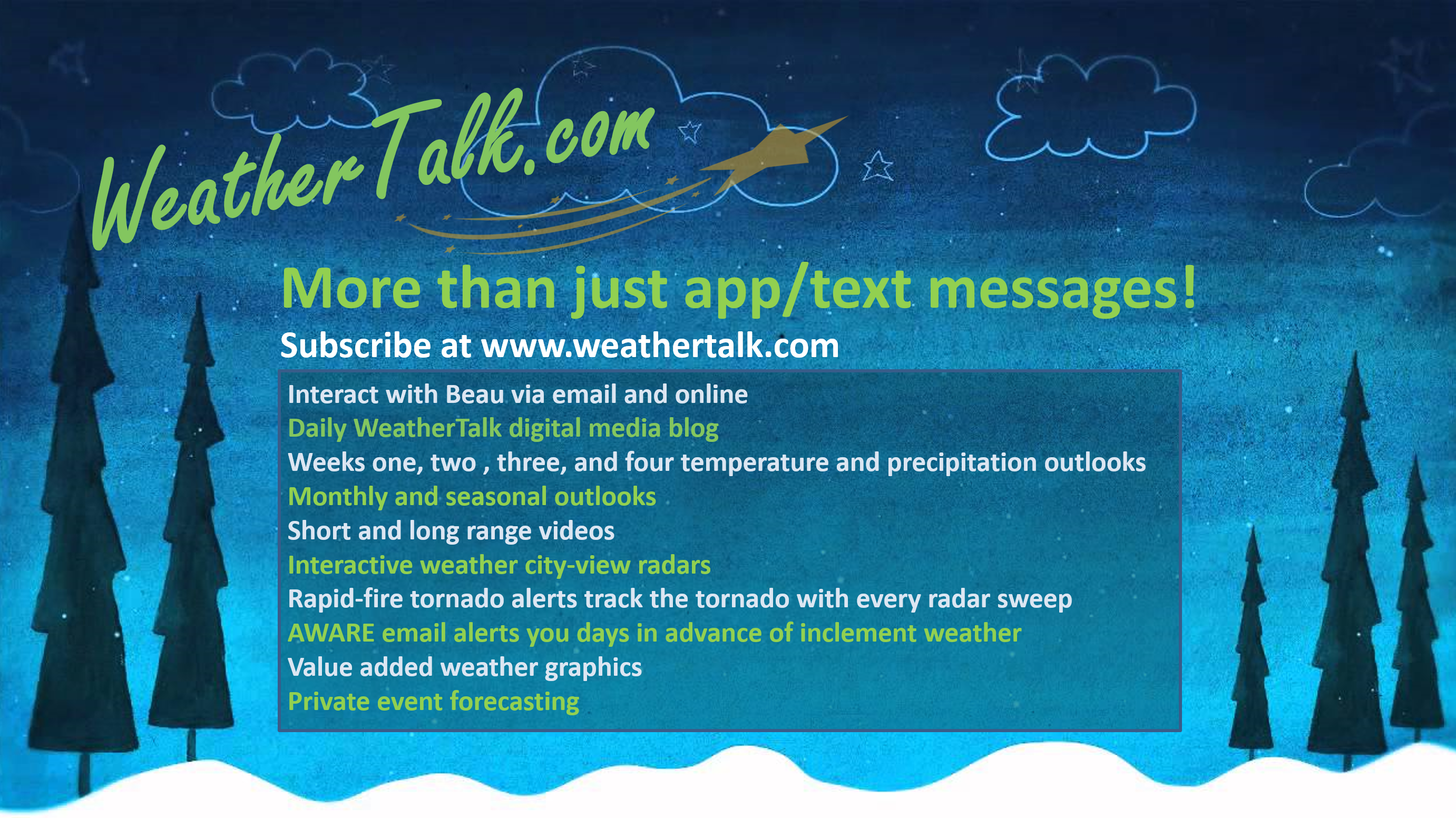
WeatherTalk monthly operating costs can top $2000.00. Your $5 subscription helps pay for those costs. I work for you.
The $5 will allow you to register up to seven phones!
For $5 a month you can receive the following. You may choose to receive these via your WeatherTalk app or regular text messaging.
Severe weather app/text alerts from my keyboard to your app/cell phone. These are hand typed messages from me to you. During tornado outbreaks, you will receive numerous app/text messages telling you exactly where the tornado is located.
- Daily forecast app/texts from my computer to your app/cell phone.
- Social media links sent directly to your app/cell phone. When I update the blog, videos, or Facebook you will receive the link.
- AWARE emails. These emails keep you well ahead of the storm. They give you several days of lead time before significant weather events.
- Direct access to Beau via text and email. Your very own personal meteorologist. I work for you!
- Missouri and Ohio Valley centered video updates
- Long-range weather videos
- Week one, two, three and four temperature and precipitation outlooks.
Monthly outlooks. - Your subscription also will help support several local charities.
Would you like to subscribe? Subscribe at www.beaudodsonweather.com
Typical progression on a severe weather day for subscribers.

.
Click one of the links below to take you directly to each section.
-
- Go to today’s forecast
- Go to the winter storm and severe weather outlook
- Go to the weather forecast discussion
- Go to the model future-cast radars
- Go to videos
- Go to weeks one, two, three, and four temperature and precipitation graphics
- Go to Weatherbrains
- View some of our charity work. Your subscription dollars help support these causes.
These are bonus videos and maps for subscribers. I bring these to you from the BAMwx team. I pay them to help with videos.
The Ohio and Missouri Valley videos cover most of our area. They do not have a specific Tennessee Valley forecast but may add one in the future.
The long-range video is technical. Over time, you can learn a lot about meteorology from the long range video. Just keep in mind, it is a bit more technical.


Subscribe at www.weathertalk.com
Click here if you would like to return to the top of the page
My regular detailed text forecast can be found below these graphics.
My text forecast below these graphics may vary a bit.
Missouri


Illinois


Kentucky


Tennessee


- Showers and thunderstorms will be the main weather story over the coming 48 hours.
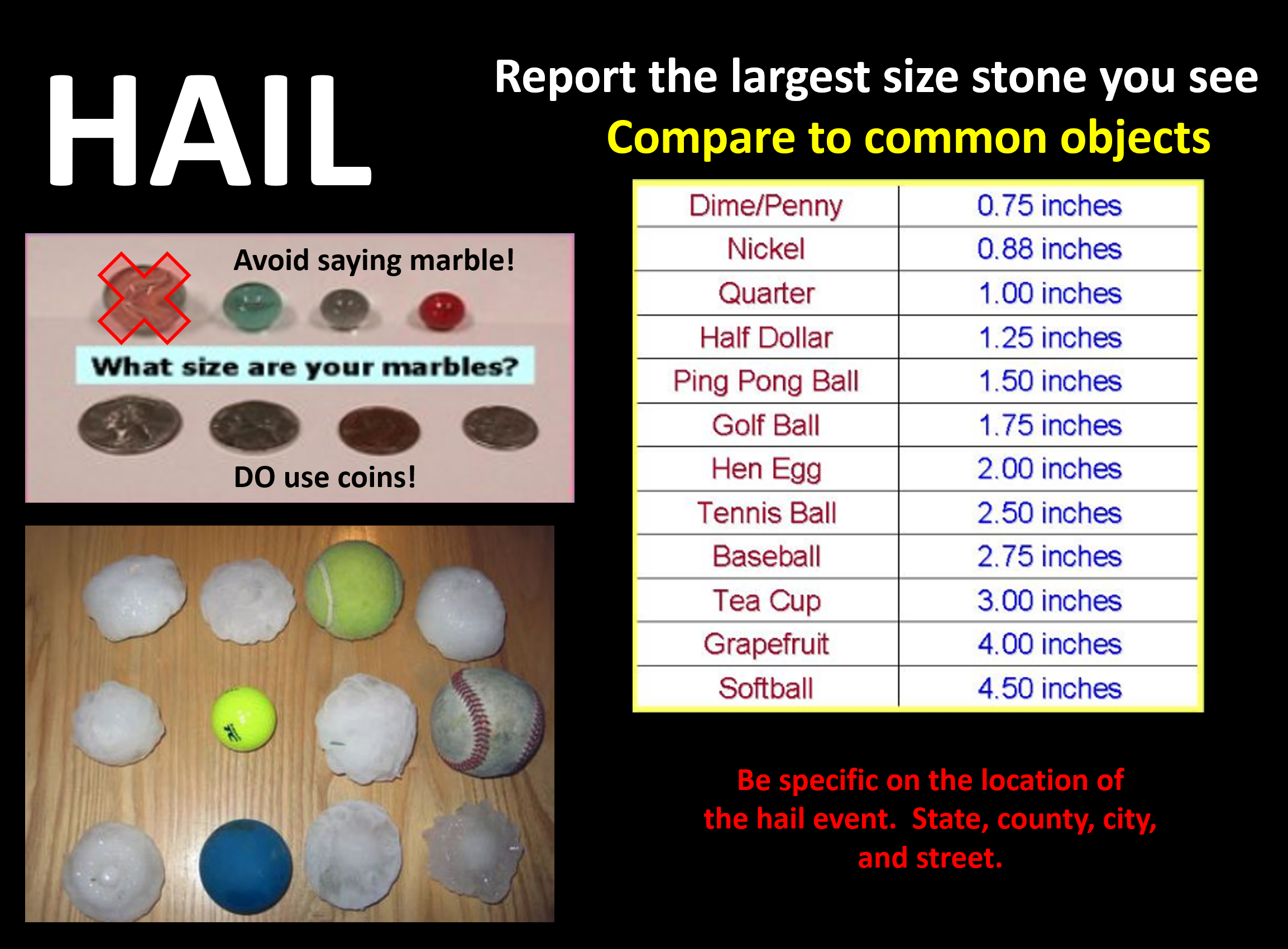
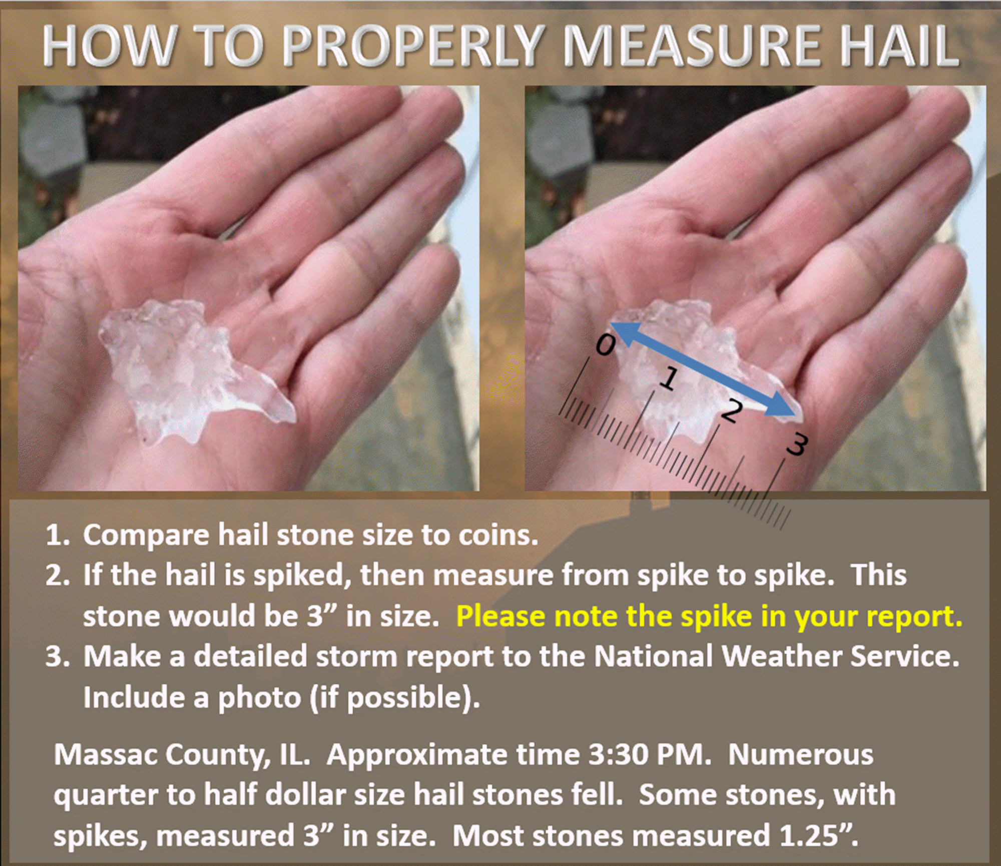
- Some hail reports are possible late tonight into Saturday.
- I am monitoring the conditional risk of severe storms Saturday.
- Dry Sunday and Monday
- Watching another system Tuesday night/Wednesday.

Today: No. Some lightning and nickel size hail will be possible late tonight/Saturday.
.
Tomorrow: Some thunderstorms could be severe on Saturday. Monitor updates. This is a conditional risk. That means if CAPE (energy for storms to tap into) does not develop then we will not have severe weather.

Confidence rating explained.
- High confidence is 70% to 100%. This means that the forecast is likely to verify.
- Medium confidence is 40% through 60%. This means that there could be adjustments in the forecast.
- Low confidence is 0% to 30%. This means that dramatic changes in the forecast are likely.
Click here if you would like to return to the top of the page

Today through Sunday night.
- Is accumulating snow or ice in the forecast? No. Some sleet is likely this morning over our far northern counties (near Mt. Vernon)
- Is lightning in the forecast? Yes. Lightning is possible Friday night and Saturday.
- Is severe weather in the forecast? Monitor. Hail is possible late tonight and on Saturday. Severe storms can’t be ruled out on Saturday.
* The NWS officially defines severe weather as 58 mph wind or great, 1″ hail or larger, and/or tornadoes - Is Flash flooding in the forecast? Monitor. Heavy rain is possible Saturday. General river flooding, however, will continue.

Monday through next Thursday the 14th
- Is accumulating snow or ice in the forecast? No.
- Is lightning in the forecast? Yes. Lightning is possible Tuesday night and Wednesday.
- Is severe weather in the forecast? Monitor. I am monitoring Wednesday and Thursday for strong storms.
* The NWS officially defines severe weather as 58 mph wind or great, 1″ hail or larger, and/or tornadoes - Is flash flooding in the forecast? Not at this time. I am monitoring next Wednesday. Locally heavy rain is possible. General river flooding will continue.
* The Missouri Bootheel includes Dunklin, New Madrid, and Pemiscot Counties
* Northwest Kentucky includes Daviess, Henderson, McLean Union, and Webster Counties
.
Today’s Facebook weather discussion link
Click here
PRELIMINARY FRIDAY UPDATE
The full update will be posted between 8 and 8:30 AM
March 8, 2019
Friday’s Forecast: Cloudy. Morning showers. A few afternoon showers.
My confidence in the forecast verifying: High (70% confidence in the forecast)
Temperature range: MO Bootheel 53° to 55° SE MO 48° to 54° South IL 46° to 50° Northwest KY (near Indiana border) 48° to 52° West KY 50° to 54° NW TN 53° to 55°
Wind direction and speed: Variable wind direction at 5 to 10 mph
Wind chill or heat index (feels like) temperature forecast: 45° to 55°
What is the chance/probability of precipitation? MO Bootheel 60% MO 50% IL 50% Northwest KY (near Indiana border) 60% Western KY 60% NW TN 70%
Note, what does the % chance actually mean? A 20% chance of rain does not mean it won’t rain. It simply means most areas will remain dry.
Coverage of precipitation: Scattered to perhaps numerous
What impacts are anticipated from the weather? Wet roadways.
Should I cancel my outdoor plans? Have a plan B. Monitor radars.
UV Index: 2 Low
Sunrise: 6:17 AM
.
Friday night Forecast: Cloudy. Scattered showers redeveloping, especially late at night. Thunderstorms possible after 3 AM. A few storms could produce hail.
My confidence in the forecast verifying: Medium (60% confidence in the forecast)
Temperature range: MO Bootheel 42° to 44° SE MO 36° to 40° South IL 36° to 42° Northwest KY (near Indiana border) 38° to 42° West KY 38° to 44° NW TN 44° to 46°
Wind direction and speed: East at 5 to 10 mph
Wind chill or heat index (feels like) temperature forecast: 32° to 40°
What is the chance/probability of precipitation? MO Bootheel 60% Southeast MO 50% Southern IL 40% Northwest KY (near Indiana border) 30% Western KY 50% NW TN 50%
Note, what does the % chance actually mean? A 20% chance of rain does not mean it won’t rain. It simply means most areas will remain dry
Coverage of precipitation: Scattered. Increasing coverage late tonight.
What impacts are anticipated from the weather? Wet roadways. Lighting. Hail possible late tonight/Saturday.
Should I cancel my outdoor plans? I would not cancel. I would monitor updates and radars.
Sunset: 5:56 PM
Moonrise: 7:35 AM
The phase of the moon: Waxing Crescent
Moonset: 7:55 PM
March 9, 2019
Saturday’s Forecast: Strong and gusty gradient winds will occur Saturday. Gusts above 40 mph are possible. Gradient winds develop when isobars (equal lines of barometric pressure) are tightly packed together. Showers and thunderstorms. Locally heavy downpours are possible. Monitor the risk of a few strong storms. Windy. A few storms could produce hail. Severe storms are possible if the atmosphere can recharge after the morning precipitation.
My confidence in the forecast verifying: High (70% confidence in the forecast)
Temperature range: MO Bootheel 63° to 66° SE MO 56° to 64° South IL 56° to 64° Northwest KY (near Indiana border) 56° to 62° West KY 62° to 65° NW TN 63° to 66°
Wind direction and speed: East and southeast 15 to 30 mph
Wind chill or heat index (feels like) temperature forecast: 54° to 58°
What is the chance/probability of precipitation? MO Bootheel 90% MO 90% IL 90% Northwest KY (near Indiana border) 90% Western KY 90% NW TN 90%
Note, what does the % chance actually mean? A 20% chance of rain does not mean it won’t rain. It simply means most areas will remain dry.
Coverage of precipitation: Widespread
What impacts are anticipated from the weather? Wet roadways. Lightning. Locally heavy rain. A few hail reports are possible. Monitor the risk of severe thunderstorms.
Should I cancel my outdoor plans? Have a plan B.
UV Index: 2 Low
Sunrise: 6:15 AM
.
Saturday night Forecast: Any remaining showers and storms will come to an end. Breezy. Becoming partly cloudy.
My confidence in the forecast verifying: High (70% confidence in the forecast)
Temperature range: MO Bootheel 38° to 44° SE MO 36° to 38° South IL 34° to 36° Northwest KY (near Indiana border) 38° to 42° West KY 38° to 44° NW TN 40° to 44°
Wind direction and speed: Southwest to west at 10 to 20 mph
Wind chill or heat index (feels like) temperature forecast: 28° to 34°
What is the chance/probability of precipitation? MO Bootheel 20% Southeast MO 20% Southern IL 30% Northwest KY (near Indiana border) 30% Western KY 30% NW TN 30%
Note, what does the % chance actually mean? A 20% chance of rain does not mean it won’t rain. It simply means most areas will remain dry
Coverage of precipitation: Ending.
What impacts are anticipated from the weather? Wet roadways early in the night.
Should I cancel my outdoor plans? I would not cancel. I would monitor updates and radars.
Sunset: 5:57 PM
Moonrise: 8:03 AM
The phase of the moon: Waxing Crescent
Moonset: 8:53 PM
March 10, 2019
Sunday’s Forecast: Mostly sunny. A few passing clouds.
My confidence in the forecast verifying: High (70% confidence in the forecast)
Temperature range: MO Bootheel 55° to 60° SE MO 53° to 56° South IL 53° to 56° Northwest KY (near Indiana border) 53° to 56° West KY 54° to 58° NW TN 56° to 66°
Wind direction and speed: West and northwest at 5 to 10 mph
Wind chill or heat index (feels like) temperature forecast: 50° to 55°
What is the chance/probability of precipitation? MO Bootheel 0% MO 0% IL 0% Northwest KY (near Indiana border) 0% Western KY 0% NW TN 0%
Note, what does the % chance actually mean? A 20% chance of rain does not mean it won’t rain. It simply means most areas will remain dry.
Coverage of precipitation: None
What impacts are anticipated from the weather? None
Should I cancel my outdoor plans? No
UV Index: 4 Medium
Sunrise: 7:15 AM
.
Sunday night Forecast: Some increase in clouds. Cool.
My confidence in the forecast verifying: Medium (60% confidence in the forecast)
Temperature range: MO Bootheel 36° to 40° SE MO 30° to 35° South IL 30° to 35° Northwest KY (near Indiana border) 32° to 34° West KY 34° to 38° NW TN 36° to 40°
Wind direction and speed: Southwest at 10 to 20 mph
Wind chill or heat index (feels like) temperature forecast: 25° to 35°
What is the chance/probability of precipitation? MO Bootheel 0% Southeast MO 0% Southern IL 0% Northwest KY (near Indiana border) 0% Western KY 0% NW TN 0%
Note, what does the % chance actually mean? A 20% chance of rain does not mean it won’t rain. It simply means most areas will remain dry
Coverage of precipitation: None
What impacts are anticipated from the weather? None
Should I cancel my outdoor plans? No
Sunset: 6:58 PM
Moonrise: 9:32 AM
The phase of the moon: Waxing Crescent
Moonset: 10:52 PM
Learn more about the UV index readings. Click here.
Monday: Partly cloudy. Increasing clouds Monday night. Highs in the mid 40’s to lower 50’s. Lows in the 30’s.
Tuesday: Mostly cloudy. Showers possible Tuesday night. Highs in the 50’s. Lows in the 40’s.
Wednesday: Showers and thunderstorms are possible. Highs in the 60’s. Lows in the 40’s.
Wind forecast


The National Weather Service defines a severe thunderstorm as one that produces quarter size hail or larger, 58 mph winds or greater, and/or a tornado.
Today and tomorrow: Some lightning will be possible late tonight. I can’t rule out some hail reports, as well. Thunderstorms are likely on Saturday. A few storms could be intense. Monitor updates.
Sunday through Friday: Lightning is possible Tuesday night. I am monitoring another chance of thunderstorms on Wednesday.
.
Be sure and have WeatherOne turned on in your WeatherTalk accounts. That is the one for winter storms, ice storms, and severe weather.
Log into your www.weathertalk.com Click the personal notification settings tab. Turn on WeatherOne. Green is on. Red is off.

.
.

Friday through next Wednesday: No accumulating snow or ice.

Here is the latest graphic from the WPC/NOAA.
This map shows you liquid and does not assume precipitation type. In other words, melted precipitation totals.
48-hour precipitation outlook.

Here is the seven-day precipitation forecast. This includes day one through seven.

Subscribers, do you need a forecast for an outdoor event?

Did you know that you can find me on Twitter? Click here to view my Twitter weather account.


Radar Link: Interactive local city-view radars & regional radars.
During winter weather be sure and click the winterize button above each city-view radar. This will show you the precipitation type.
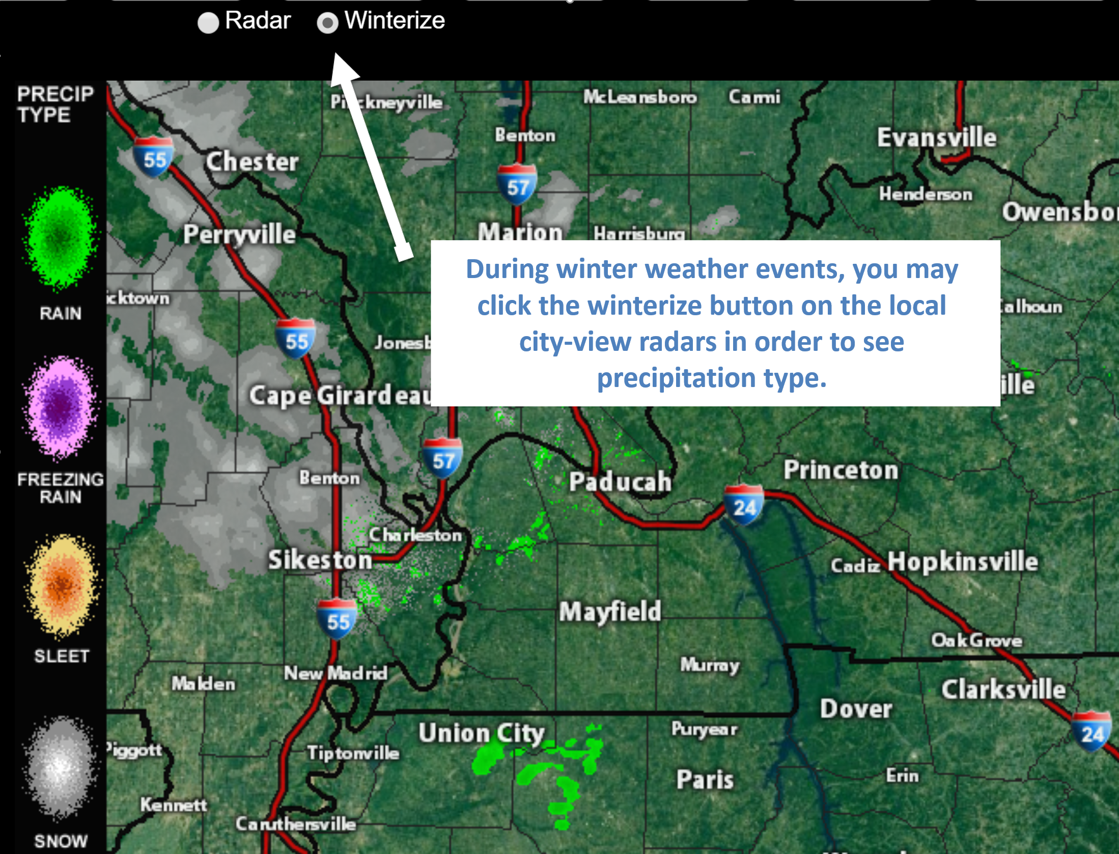
Click the image for an example of how to show winter precipitation type
You will also find clickable warning and advisory buttons on the local city-view radars.
If the radar is not updating then try another one. If a radar does not appear to be refreshing then hit Ctrl F5. You may also try restarting your browser.
Not working? Email me at beaudodson@usawx.com
National map of weather watches and warnings. Click here.
Weather Prediction Center. Click here..
.

Live lightning data: Click here.
.

Interactive GOES R satellite. Track clouds. Click here.
GOES 16 slider tool. Click here.
College of Dupage satellites. Click here
.

Here are the latest local river stage forecast numbers Click Here.
Here are the latest lake stage forecast numbers for Kentucky Lake and Lake Barkley Click Here.

- Rain showers today.
- Rain and storms likely late tonight. A few hail reports possible late tonight into Saturday.
- Thunderstorms are likely on Saturday. Some locally moderate to heavy downpours. I am monitoring the risk of intense storms Saturday afternoon.
Have there been any changes in the forecast over the last 24 hours?
No major adjustments. I did ramp up the wording concerning hail late tonight and Saturday.
Does the forecast require action?
Yes. Monitor Saturday’s forecast. Some locally heavy rain is possible. Hail is possible late tonight and on Saturday. I am monitoring the risk of a few severe storms, as well.
Yes. Avoid flooded roadways.
Widespread river flooding continues across the region.
Click here if you would like to return to the top of the page
Forecast discussion.
We have an active 48 hours of weather ahead of us.
Let’s break it down.
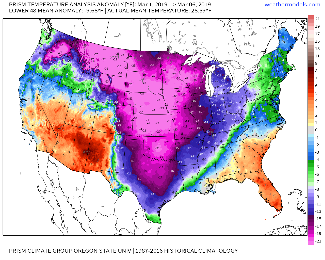
First, I wanted to show you the crazy temperature anomalies for the Month of March, thus far.
Talk about starting out on a cold note!
These numbers represent how many degrees below normal temperatures have been since March 1st.
Today into the weekend.
Today will deliver clouds with patchy drizzle and light rain. Sleet will continue to be possible across northern parts of southern Illinois. Watch those bridges because they freeze first.
We have a lull this afternoon and this evening. Any rain showers during this time-frame will be light.
Widespread showers and thunderstorms will develop late tonight into Saturday. They will develop to our south and west and spread east/northeast.
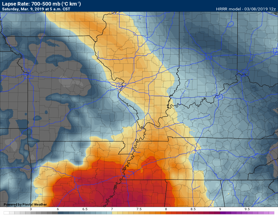
Some of the storms late tonight could produce locally heavy rain, gusty winds, lightning, and even some hail reports. The atmosphere will rapidly cool as you move upward. This will make conditions favorable for some hail reports.
We call this cooling with height lapse rates.
Here is the 5 AM lapse rate map. Those are decent numbers for the production of hail.
Seven and above are decent when it comes to forecasting hail.
All eyes then turn to what happens after the morning round of showers and thunderstorms.
The morning round of rain/storms will stabilize the atmosphere. That puts a cap on severe weather concerns.
We then have to monitor what happens after 11 AM.
IF the atmosphere can recharge then thunderstorms will redevelop along an incoming cold front and dry line.
Some of these storms could become severe.
This is a conditional severe weather risk. What does conditional mean? Same as two weeks ago. If CAPE (energy for storms to tap into) does not develop then we won’t have severe weather.
If, however, the atmosphere can destabilize then all modes of severe weather will be possible. That includes damaging wind, hail, and tornadoes. The risk is conditional.
We won’t know if this is going to happen until we see how widespread the clouds and rain are during the first half of Saturday.
Monitor updates this weekend. Remember, a watch means to monitor updates. A warning means to seek shelter. Warning trumps watch. Warning means severe weather may be imminent.
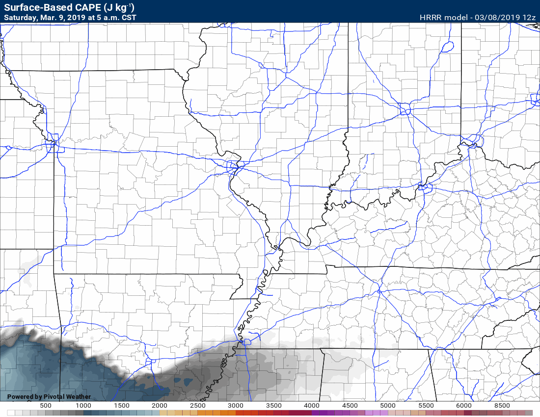
Here is the Hrrr model guidance CAPE forecast. It produces CAPE for storms to redevelop. Again, keep in mind, this is one model. Some models show no CAPE.
Watch Saturday late morning into the PM hours. CAPE builds in from the south and southwest. This is highly dependent on the morning clouds and precipitation leaving the area.
If clouds and rain linger then the atmosphere may not recharge.
This is a conditional severe weather risk.
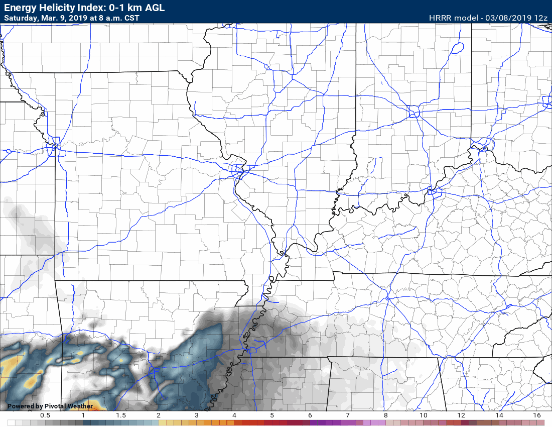
There will be plenty of spin in the atmosphere, as well.
Here are the EHI numbers. EHI basically means there is rotation in the atmosphere.
IF severe weather does develop then tornadoes will certainly be possible.
This could be another all or nothing event.
Strong and gusty gradient winds will occur Saturday. Gusts above 40 mph are possible. Gradient winds develop when isobars (equal lines of barometric pressure) are tightly packed together.
Click here if you would like to return to the top of the page
Model Future-cast Radars. What the models believe the radar may look like.
Let’s take a look at the high-resolution Hrrr model guidance future-cast radar.
Timestamp upper left.
Notice the AM storms? Some of those could produce hail.
The Hrrr model does redevelop storms tomorrow afternoon. It does show the potential of severe weather.
Not all models agree. There remain questions about whether redevelopment will occur.
The best advice is to monitor updates.
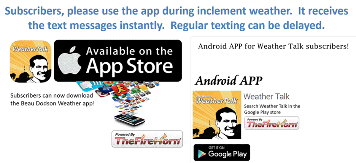
I will be sending out app/text (please use the app since Verizon and ATT are throttling texts) messages. The app receives the messages instantly.

River Flooding To Continue
River flooding is going to continue through the week. I know many of you are having flooding issues.
Speaking of flooding, here are some links to help you track the crest numbers.
Here are the latest local river stage forecast numbers Click Here.
Here are the latest lake stage forecast numbers for Kentucky Lake and Lake Barkley Click Here.
Current conditions.

Forty-eight-hour temperature outlook.


end
end
![]()
These are bonus videos and maps for subscribers. I bring these to you from the BAMwx team. I pay them to help with videos.
The Ohio and Missouri Valley videos cover most of our area. They do not have a specific Tennessee Valley forecast but they may add one in the future.
The long-range video is a bit technical. Over time, you can learn a lot about meteorology from the long range video.
NOTE: These are usually not updated on Saturday or Sunday unless there is active weather.
.
Click here if you would like to return to the top of the page
The Ohio Valley video
Long-range This video.
The Missouri Valley video (is usually updated during the late morning hours)
.![]()

Here is the latest WPC/NOAA 6 to 10 & 8 to 14-day temperature outlooks.
** NOTE: See our own more detailed in-house long-range forecast graphics below these. They may not always agree **
The cool colors indicate below normal temperatures. The darker the blue the greater the chance of below normal temperatures.
The warm colors represent the probability of above normal temperatures.
Days six through ten temperature outlook
Confidence % that it will be above or below normal?
Days six through ten precipitation outlook
Confidence % that it will be above or below normal?
The darker colors represent high confidence in above normal precipitation.
Days eight through fourteen temperature outlook
Confidence % that it will be above or below normal?
Days eight through fourteen precipitation outlook
Confidence % that it will be above or below normal?
The darker colors represent high confidence in above normal precipitation.
Remember, long-range outlooks are always going to be a lower confidence level than short-term forecasts.
Long-range forecasting is not an exact science. There are many variables that determine the eventual outcome of a long-range forecast.

.
Outlook definitions
EC = Equal chances of above or below normal
BN= Below normal
M/BN = Much below normal
AN = Above normal
M/AN = Much above normal
E/AN = Extremely above normal
Normal high temperatures for this time of the year are around 52 degrees.
Normal low temperatures for this time of the year are around 32 degrees.
Normal precipitation during this time period ranges from 0.75″ to 1.00″
This outlook covers March 4th through March 10th
The precipitation forecast is PERCENT OF NORMAL. For example, if your normal rainfall is 1.00″ and the graphic shows 25%, then that would mean 0.25″ of rain is anticipated.

Normal high temperatures for this time of the year are around 55 degrees
Normal low temperatures for this time of the year are around 35 degrees
Normal precipitation during this time period ranges from 0.75″ to 1.00″
This outlook covers March 11th through the 18th
The precipitation forecast is PERCENT OF NORMAL. For example, if your normal rainfall is 1.00″ and the graphic shows 25%, then that would mean 0.25″ of rain is anticipated.

.
Outlook definitions
EC = Equal chances of above or below normal
BN= Below normal
M/BN = Much below normal
AN = Above normal
M/AN = Much above normal
E/AN = Extremely above normal
Normal high temperatures for this time of the year are around 57 degrees
Normal low temperatures for this time of the year are around 38 degrees
Normal precipitation during this time period ranges from 1.50″ to 1.90″
This outlook covers March 15th through March 28th
The precipitation forecast is PERCENT OF NORMAL. For example, if your normal rainfall is 1.00″ and the graphic shows 10%, then that would mean 0.10″ of rain is anticipated.

.
Outlook definitions
EC= Equal chances of above or below normal
BN= Below normal
M/BN = Much below normal
AN = Above normal
M/AN = Much above normal
E/AN = Extremely above normal
.
March temperature and precipitation outlook
April temperature and precipitation outlook
May temperature and precipitation outlook
Here is the preliminary March, April, and May temperature and precipitation forecast.
Temperature outlook
Precipitation outlook


Tonight’s Guest WeatherBrain is Glenn “Hurricane” Schwartz, an on-air broadcast meteorologist at WCAU-TV in Philadelphia, PA. In addition, also joining us from WCAU-TV is on-air broadcast meteorologist Steven Sosna. Gentleman, welcome to WeatherBrains!
Also joining us is the Chief scientist/SOO at the National Weather Service in Birmingham, AL. Kevin Laws, welcome to the show!
Last but not least, Joel Housman is joining us this week to celebrate National Weather Podcast Month. Hailing from Washington DC, he runs Ice Station Housman and is a weather enthusiast. Welcome to the show, Joel!
Other discussions in this weekly podcast include topics like:
- 23 killed in EF4 Lee County, Alabama tornado on 3/3
- National Weather Podcast Month
- The Astronomy Report from Tony Rice
- National Weather round-up
- and more!
.
.
Previous episodes can be viewed by clicking here.
Find Beau on Facebook! Click the banner.

.
Find Beau on Twitter! Share your weather photos! @beaudodson

Click here to go to the top of the page
Did you know that a portion of your monthly subscription helps support local charity projects? Not a subscriber? Becoming one at www.weathertalk.com
You can learn more about those projects by visiting the Shadow Angel Foundation website and the Beau Dodson News website.
