
Are you in need of new eye glasses? New contacts? Perhaps you need an eye exam. Then be sure and visit the Eye Care Associates of western Kentucky (the Paducah location). For all of your families eye care needs.
Visit their web-site here. Or, you can also visit their Facebook page.

Best at Enabling Body Shop Profitability since 1996. Located In Paducah Kentucky and Evansville Indiana; serving all customers in between. They provide Customer Service, along with all the tools necessary for body shops to remain educated and competitive. Click the logo above for their main web-site.
You can find McClintock Preferred Finishes on Facebook, as well

Expressway Carwash and Express Lube are a locally owned and operated full-service Carwash and Lube established in 1987.
They have been proudly serving the community for 29 years now at their Park Avenue location and 20 years at their Southside location. They have been lucky enough to partner with Sidecar Deli in 2015, which allows them to provide their customers with not only quality service, but quality food as well.
If you haven’t already, be sure to make Expressway your one-stop shop, with their carwash, lube and deli. For hours of operation and pricing visit www.expresswashlube.com or Expressway Carwash on Facebook.

The quad states area source for Precision Ag Technology. Locally owned and operated, specializing in planting, harvesting, fertilizer application and drainage. Visit them on their website and on Facebook. You can also find them on Twitter. They are located in Almo, Kentucky. Phone 270-718-0245
.———————————————–
The Beau Dodson Weather APP is ready for Apple and Android users. The purpose of this APP is for me to deliver your text messages instantly. ATT and Verizon have not always been reliable when it comes to speed. The APP allows instant delivery.
Some of you have asked if you can keep receiving the texts on your phone and the app. The answer to that is, yes. The Android app will automatically allow that to happen. On the Apple app, however, you will need to go into your app and click settings. Make sure the green tab is OFF. Off means you will still receive the texts to your phone and the app. If you have any questions, then email me at beaudodson@usawx.com
The APP is for text subscribers.
The direct download, for the Apple app, can be viewed here
https://itunes.apple.com/us/app/id1190136514
If you have not signed up for the texting service then you may do so at www.beaudodsonweather.com

The Android APP is also ready.
Remember, the APP’s are for www.weathertalk.com subscribers. The app allows your to receive the text messages faster than ATT and Verizon.
Here is the download link for the Android version Click Here

——————————————————–
If you have not signed up for the texts messages, then please do. Link www.beaudodsonweather.com
Your support helps with the following:

and

.

This forecast update covers far southern Illinois, far southeast Missouri, and far western Kentucky. See the coverage map on the right side of the blog
Interactive Weather Radar Page. Choose the city nearest your location: Click this link—
Monday Night Forecast Details:
Forecast: High wind alert. Strong and gusty gradient winds of 30 to 55 mph are anticipated between 7 PM and 4 AM. These winds could cause some problems with power lines and tree branches. These are non-thunderstorm winds. Cloudy. Showers and thunderstorms developing. Late tonight a line of storms will push through the region from west to east. This line of storms could produce pockets of high winds and hail. Isolated tornado risk over southeast Missouri and southwest Illinois. The risk for severe weather lessens as you move further east in the region. See discussion below. Locally heavy rain possible. Some areas should top one inch of rain. It is dry.
What impacts are anticipated from the weather? Wet roadways. Lightning. Strong storms possible. Monitor watches and warnings.
Is severe weather expected? Yes. Some storms could be severe tonight into early Tuesday morning.
The NWS defines severe weather as 58 mph winds or great, 1″ hail or larger, and/or tornadoes
What is the chance of precipitation? MO ~ 100% IL ~ 100% KY ~ 100% TN ~ 100%
Coverage of precipitation: Numerous and widespread.
Should I cancel my outdoor plans? Have alternative plans.
My confidence in the forecast verifying: High. This forecast should verify.
Temperatures: MO ~ 55 to 60 IL ~ 55 to 60 KY ~ 55 to 60 TN ~ 55 to 60
Winds: South and southwest at 15 to 30 mph with gusts to 55
Wind Chill when applicable:
Will there be a chance for wintry precipitation? No
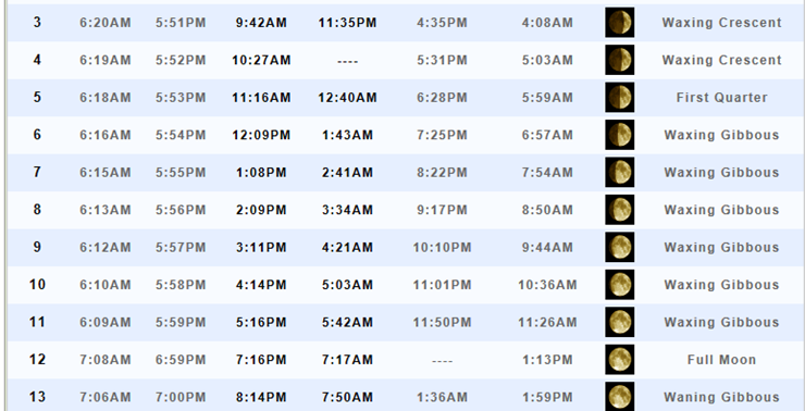
Moonrise will be at 12:09 p.m. and moonset will be at 1:43 a.m. Waxing Gibbous
.
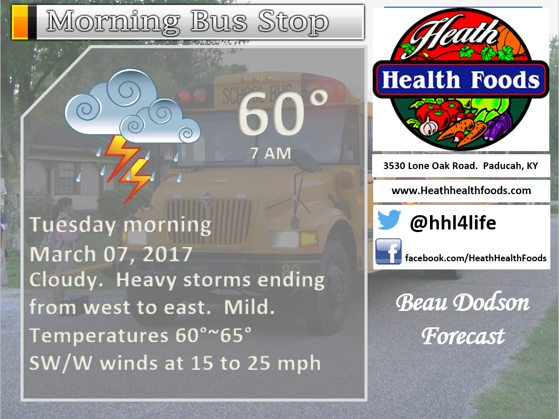
March 7, 2017
Tuesday Forecast Details
Forecast: Cloudy. Morning showers and thunderstorms. A few heavy downpours possible as the cold front moves through the region during the morning hours. Rain chances peak during the morning and the decrease through the day. Rain should completely exit southeast Missouri between 7 am and 10 am. Southern Illinois between 8 am and 11 am. Western Kentucky and western Tennessee between 10 am and 2 pm. Further east the rain lingers longer compared to west. Line moves from west to east through the region.
What impacts are anticipated from the weather? Wet roadways and lightning. Gusty winds along the line of storms. Pockets of damaging winds can’t be ruled out.
Is severe weather expected? Yes. Some storms between 12 am and 8 am could be severe. Damaging winds would be the main concern. A few reports of hail possible. Tornado risk is not zero, but is not great.
The NWS defines severe weather as 58 mph winds or great, 1″ hail or larger, and/or tornadoes
What is the chance of precipitation? MO ~ 100% (before 7 am) IL ~ 100% (before 10 am) KY ~ 100% during the morning hours TN ~ 100% during the morning hours.
Coverage of precipitation: Numerous before 10 am and then decreasing through the day.
Should I cancel my outdoor plans? Have an alternative plan during the morning hours.
My confidence in the forecast verifying: High. This forecast should verify.
Temperatures: MO ~ 60 to 65 IL ~ 60 to 65 KY ~ 60 to 65 TN ~ 60 to 65 (temps may fall a bit after frontal passage)
Winds: West and southwest winds becoming west and northeast at 6 to 12 mph with gusty winds.
Wind Chill when applicable:
Will there be a chance for wintry precipitation? No
Sunrise will be at 6:15 a.m. and sunset will be at 5:55 p.m.
UV Index: 0 to 2
Moonrise will be at 1:08 p.m. and moonset will be at 2:41 a.m. Waxing Gibbous
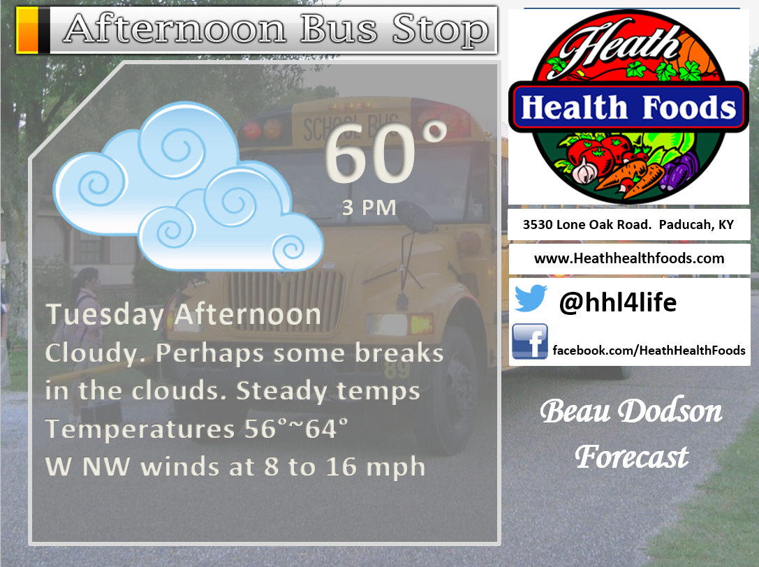
Tuesday Night Forecast Details:
Forecast: Mostly clear and cool.
What impacts are anticipated from the weather? None
Is severe weather expected? No
The NWS defines severe weather as 58 mph winds or great, 1″ hail or larger, and/or tornadoes
What is the chance of precipitation? MO ~ 0% IL ~ 0% KY ~ 0% TN ~ 10%
Coverage of precipitation: None
Should I cancel my outdoor plans? No.
My confidence in the forecast verifying: High. This forecast should verify.
Temperatures: MO ~ 36 to 42 IL ~ 36 to 42 KY ~ 38 to 44 TN ~ 40 to 45
Winds: West and southwest at 6 to 12 mph before midnight and then variable at less than 5 mph after midnight.
Wind Chill when applicable:
Will there be a chance for wintry precipitation? No
Moonrise will be at 1:08 p.m. and moonset will be at 2:41 a.m. Waxing Gibbous
.
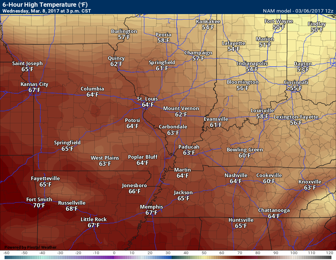
March 8, 2017
Wednesday Forecast Details
Forecast: Mostly sunny. Warm for early March.
What impacts are anticipated from the weather? None.
Is severe weather expected? No.
The NWS defines severe weather as 58 mph winds or great, 1″ hail or larger, and/or tornadoes
What is the chance of precipitation? MO ~ 0% IL ~ 0% KY ~ 0% TN ~ 0%
Coverage of precipitation: None
Should I cancel my outdoor plans? Have an alternative plan
My confidence in the forecast verifying: Medium. Some adjustments are possible.
Temperatures: MO ~ 62 to 66 IL ~ 62 to 66 KY ~ 62 to 66 TN ~ 62 to 66
Winds: Southwest at 5 to 10 mph with gusts to 15 mph
Wind Chill when applicable:
Will there be a chance for wintry precipitation? No
Sunrise will be at 6:13 a.m. and sunset will be at 5:56 p.m.
UV Index: 5 to 7
Moonrise will be at 2:09 p.m. and moonset will be at 3:34 a.m. Waxing Gibbous
Wednesday Night Forecast Details:
Forecast: Clear. Cool.
What impacts are anticipated from the weather? None.
Is severe weather expected? No
The NWS defines severe weather as 58 mph winds or great, 1″ hail or larger, and/or tornadoes
What is the chance of precipitation? MO ~ 0% IL ~ 0% KY ~ 0% TN ~ 0%
Coverage of precipitation: None
Should I cancel my outdoor plans? No.
My confidence in the forecast verifying: Medium. Some adjustments are possible.
Temperatures: MO ~ 38 to 44 IL ~ 38 to 44 KY ~ 38 to 44 TN ~ 40 to 45
Winds: West and southwest at 5 mph
Wind Chill when applicable:
Will there be a chance for wintry precipitation? No
Moonrise will be at 2:09 p.m. and moonset will be at 3:34 a.m. Waxing Gibbous
.
March 9, 2017
Thursday Forecast Details
Forecast: Mostly sunny. A few passing clouds during the morning. Then, becoming cloudy late in the day. A slight chance for showers after 2 pm. Warm for early March with well above normal temperatures.
What impacts are anticipated from the weather? Perhaps wet roadways late in the day.
Is severe weather expected? No.
The NWS defines severe weather as 58 mph winds or great, 1″ hail or larger, and/or tornadoes
What is the chance of precipitation? MO ~ 30% IL ~ 20% KY ~ 20% TN ~ 20%
Coverage of precipitation: Late in the day a few showers possible.
Should I cancel my outdoor plans? No
My confidence in the forecast verifying: Medium. Some adjustments are possible.
Temperatures: MO ~ 64 to 70 IL ~ 64 to 70 KY ~ 64 to 70 TN ~ 64 to 70
Winds: South at 10 mph with gusts to 20 mph
Wind Chill when applicable:
Will there be a chance for wintry precipitation? No
Sunrise will be at 6:12 a.m. and sunset will be at 5:57 p.m.
UV Index: 3 to 6
Moonrise will be at 3:11 p.m. and moonset will be at 4:21 a.m. Waxing Gibbous
Thursday Night Forecast Details:
Forecast: Mostly cloudy. Showers and some thunderstorms.
What impacts are anticipated from the weather? Wet roadways possible. Lightning.
Is severe weather expected? No
The NWS defines severe weather as 58 mph winds or great, 1″ hail or larger, and/or tornadoes
What is the chance of precipitation? MO ~ 60% IL ~ 60% KY ~ 60% TN ~ 60%
Coverage of precipitation: Scattered to perhaps numerous
Should I cancel my outdoor plans? No, but monitor updates.
My confidence in the forecast verifying: Medium. Some adjustments are possible.
Temperatures: MO ~ 45 to 50 IL ~ 45 to 50 KY ~ 45 to 50 TN ~ 45 to 50
Winds: South and southwest at 5 to 10 mph. Gusty at times
Wind Chill when applicable:
Will there be a chance for wintry precipitation? No
Moonrise will be at 3:11 p.m. and moonset will be at 4:21 a.m. Waxing Gibbous
I am carefully monitoring a storm system for Saturday and Sunday. Check back for updates.
More information on the UV index. Click here
The School Bus Stop Forecast is sponsored by Heath Health and Wellness.
Located next to Crowell Pools in Lone Oak, Kentucky.
Visit their website here. Visit Heath Health Foods on Facebook!

Heath Health Foods is a locally owned and operated retail health and wellness store. Since opening in February 2006; the store has continued to grow as a ministry with an expanding inventory which also offers wellness appointments and services along with educational opportunities.
Visit their web-site here. And. visit Heath Health Foods on Facebook!.


Don’t forget to check out the Southern Illinois Weather Observatory web-site for weather maps, tower cams, scanner feeds, radars, and much more! Click here

An explanation of what is happening in the atmosphere over the coming day
Analysis
Monday night into Tuesday afternoon
Confidence: High
The focus of today’s update is on the severe weather potential for tonight and Tuesday morning. Another system is possible this coming weekend.
Monitor updates, as always.
Interactive Weather Radar Page. Choose the city nearest your location: Click this link—
National interactive radar: Click this link..
Local interactive city radars include St Louis, Mt Vernon, Evansville, Poplar Bluff, Cape Girardeau, Marion, Paducah, Hopkinsville, Memphis, Nashville, Dyersburg, and all of eastern Kentucky. These are interactive radars. Local city radars – click here
Regional Radar

Forecast:
Tonight is NOT the same set-up as last weeks tornado outbreak.
Instability is weaker tonight, wind shear is weaker, the atmosphere is not nearly as unstable. Keep that in mind.
The main concern tonight will be a squall line. A squall line is a long line of thunderstorms that can stretch across several states. Squall lines typically produce gusty winds, some reports of dime to quarter size hail, and isolated QLCS tornadoes.
What is a QLCS tornado? There are typically two types of tornadoes (in our local area). The supercell tornadoes that can track for dozens of miles and produce winds of 150+ mph and the QLCS tornadoes. The QLCS tornadoes are usually embedded within the leading edge of a squall line. They are short lived. They can range from 10′ wide to a few hundred feet wide. They are typically rated EF0 to EF1. Low end of the tornado wind speed scale. An EF0 and EF1 tornado can produce winds of 80 to 110 mph. They can cause damage and should not be trivialized.
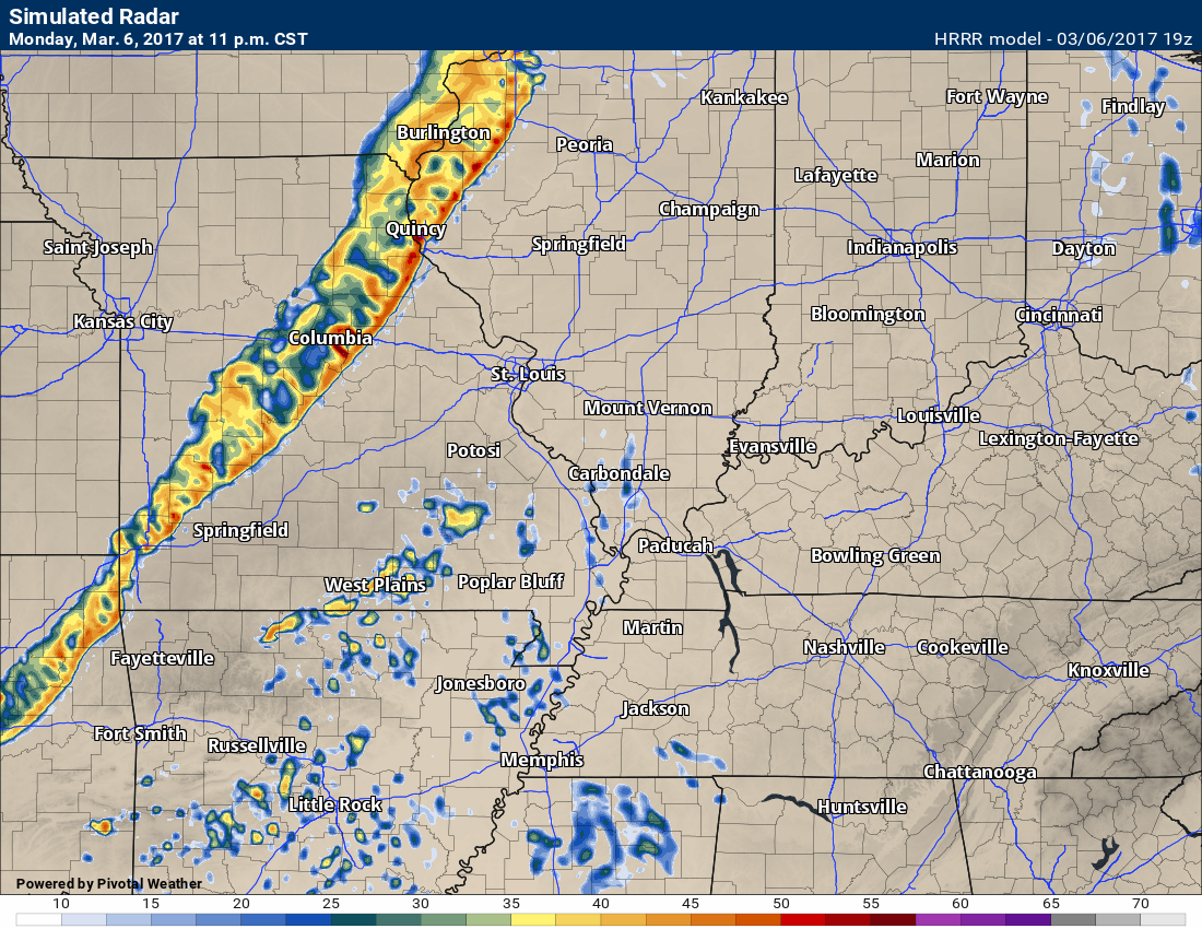
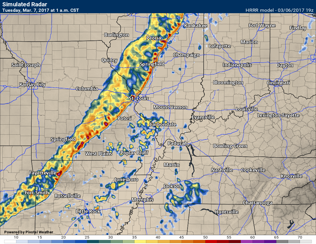
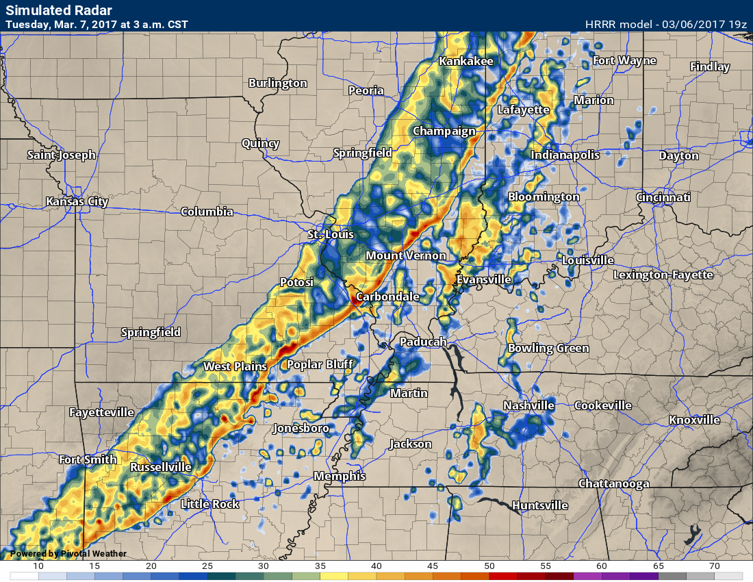
The setup tonight will be a line of storms advancing into southeast Missouri and southwest Illinois after 11 pm. The line will move west to east. The line will exit our region between 7 am and 10 am on Tuesday morning. It will linger the longest over the Pennyrile area of western Kentucky.
Moderate to heavy rains are possible tonight. Some areas should top one inch of rain.
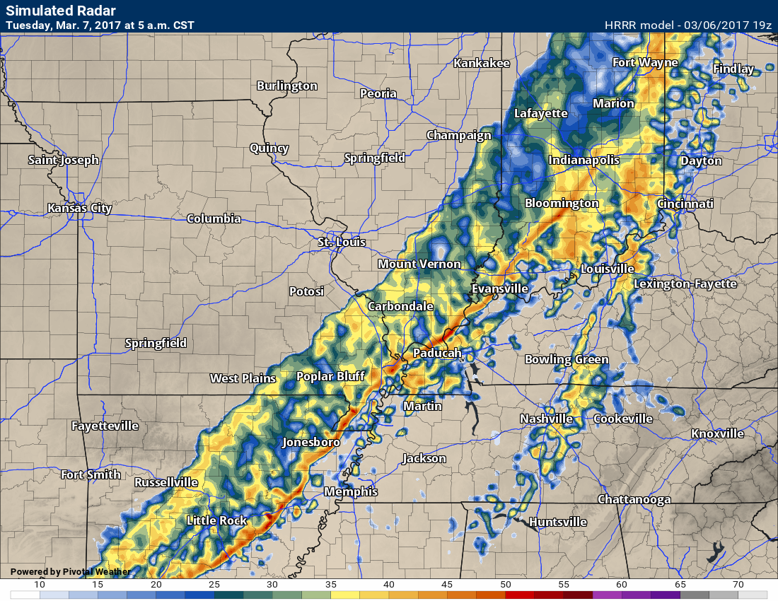
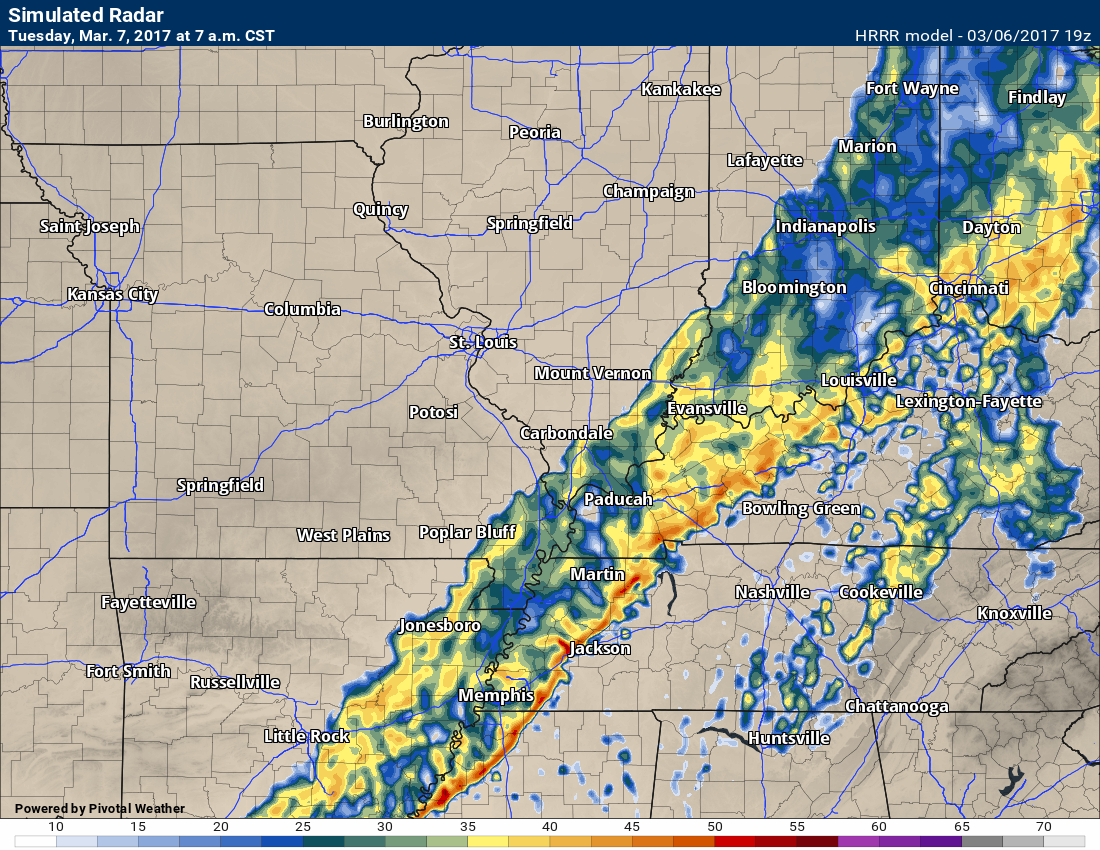
I will post some future-cast radar images.
Here is the future-cast radar
Remember, this is a MODEL. It is not gospel. Take the general idea from it and not the specifics.
This is what radar MIGHT look like late tonight into Tuesday morning.
11 PM Monday night radar
1 AM Tuesday morning radar
3 AM radar for Tuesday morning
5 AM radar for Tuesday morning
7 AM future-cast radar for Tuesday morning
The greatest risk zone will be over southeast Missouri and southwest Illinois. Here is the SPC severe weather outlook.
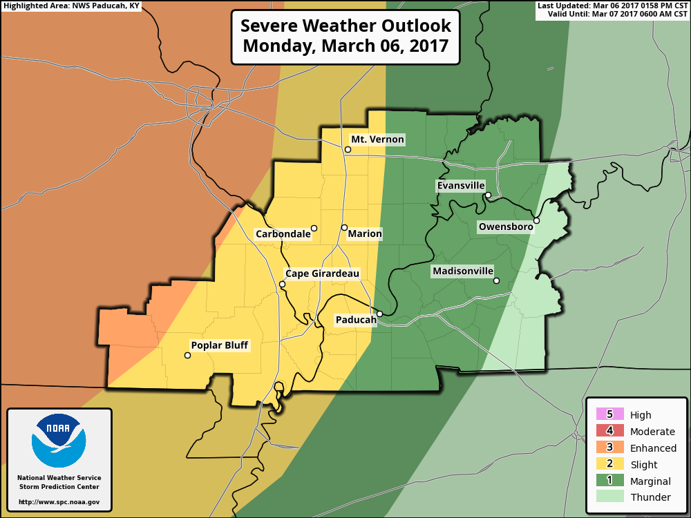
To check updated outlooks and watches – click here
The greatest risk is the orange zone. The risk below that is the yellow zone. The dark green is a marginal risk for severe storms. The light green is where thunderstorms may occur, but should not be severe.
The orange zone is an enhanced risk for severe thunderstorms. That means that severe storms will likely occur and quite a few reports of wind damage, hail, and even isolated tornadoes are anticipated. The yellow zone is a slight risk for severe thunderstorms. The Storm Prediction Center is the one who names the yellow zone. Slight risk might be confusing. It actually means that some severe storms are likely to occur, but that the number of reports should be limited.
Keep in mind, the SPC will update this graphic at least once or twice between now and late tonight.
It only takes one severe storm to ruin the day. Thus, monitor watches and warnings. A warning means to take action. A warning means to seek shelter.
The squall line will be moving into less unstable air as it approaches southeast Illinois and western Kentucky/Tennessee. With that said, I can’t completely rule out some reports of severe weather in those areas, as well.
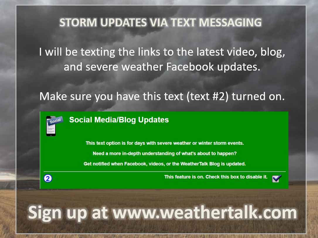
This will be a late night event. Monitor watches and warnings. I will have live feeds on the Beau Dodson Weather Facebook page. Keep your weather radios on. Make sure you have signed up for the text messages at www.weathertalk.com
Make sure you have TEXT OPTION ONE ON. That is the Weather Warn text. That is the one for tornado information, severe storm information.
Also, if you would like to receive the text messages for severe weather updates via videos, Facebook, and the blog, then make sure text option two is turned on.
Rain will end during the late morning and early afternoon hours.
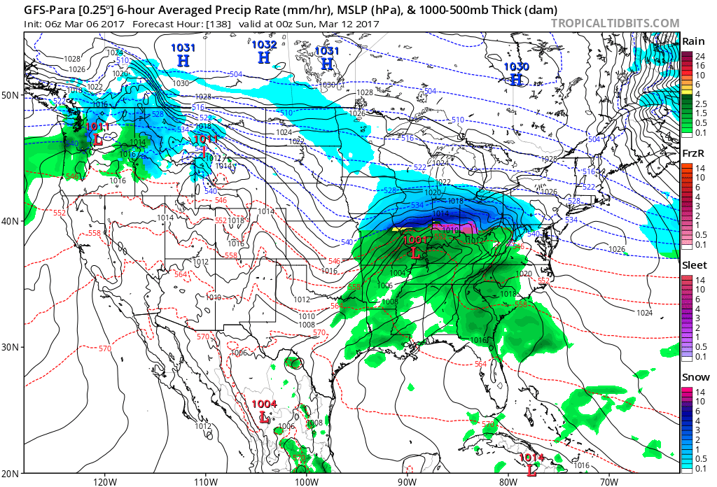
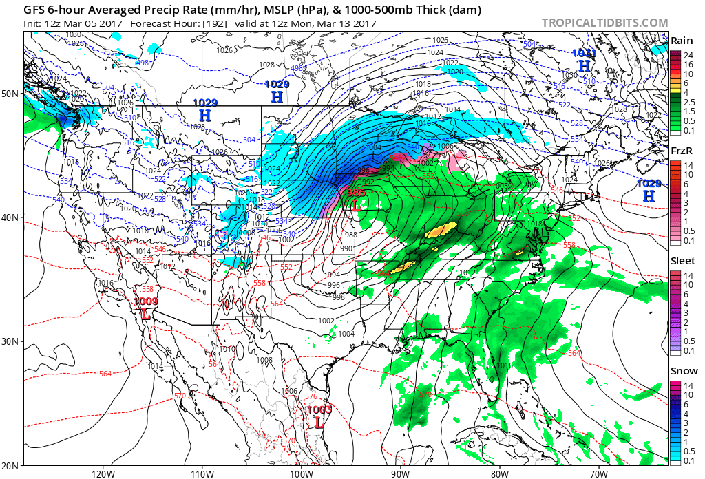
Weekend system:
Another storm system is poised to move into our region on Saturday and Sunday. This system has the potential to produce all types of weather in the Missouri and Ohio Valley’s. That would include snow.
The track of the system is key to our sensible weather conditions. If the low tracks to our north then storms will likely occur. Some of the storms could be intense. On the other hand, if the storm tracks far enough south then a wintry mix could occur over some of our local counties.
Monitor updated forecasts.
This is the GFS parallel run. Dark blue is heavy snow. Red is sleet and ice. Green would be rain and storms.
Let’s keep an eye on it.
.
Find me on Twitter

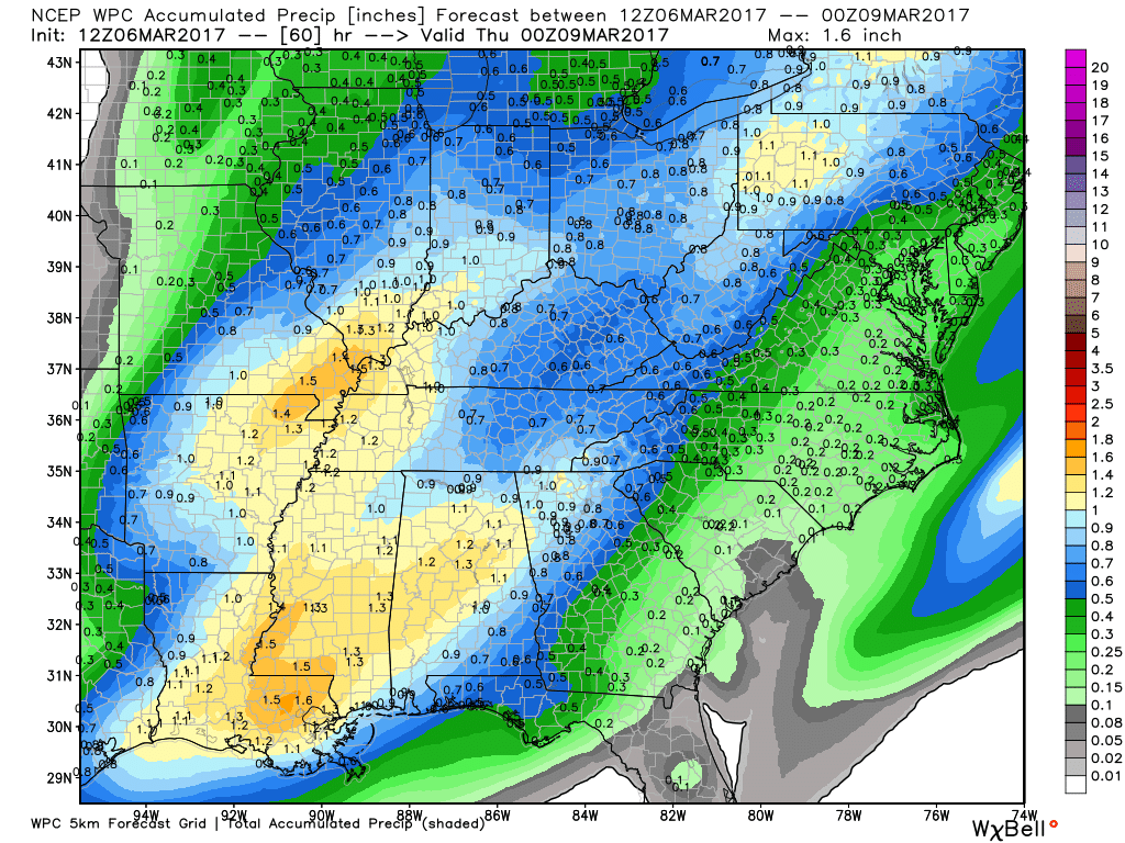
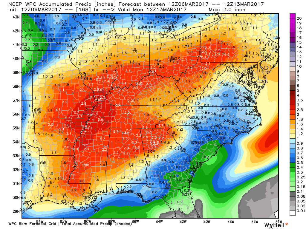
How much rain is expected over the coming days?
Here is the official NOAA rainfall prediction
Monday night into Tuesday
Click image to enlarge
This next graphic is the rainfall from Monday through next weekend. Another precipitation maker is likely later this week.
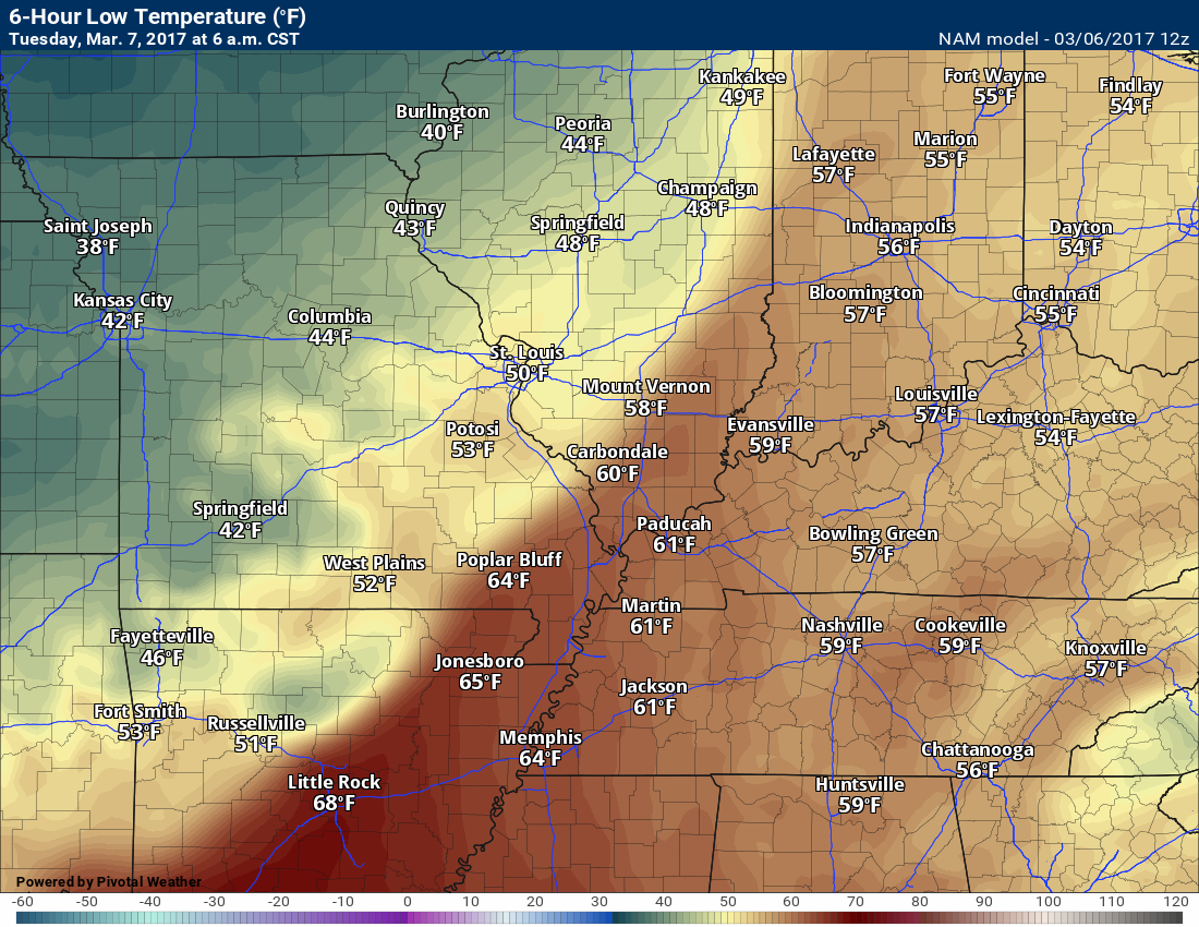
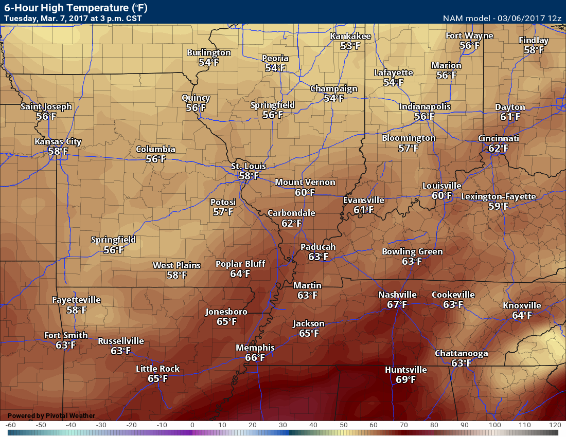
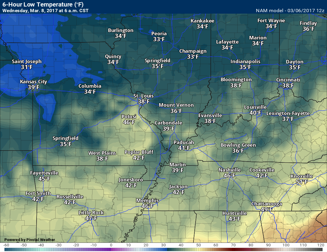
High and Low-Temperature Outlook
Tuesday low temperature forecast
Tuesday afternoon high temperature forecast
Wednesday low temperature forecast
Wednesday high temperature forecast

Strong to severe storms late Monday night into Tuesday morning. A few watches and warnings will likely be issued. Monitor updates
.

Severe thunderstorm outlook.
Remember that a severe thunderstorm is defined as a thunderstorm that produces 58 mph winds or higher, quarter size hail or larger, and/or a tornado.
Monday night and Tuesday morning: A line of thunderstorms (squall line) will push across the region late Monday night into the wee hours of Tuesday morning. The line of storms will be most intense over southeast Missouri and southwest Illinois. The line will weaken, somewhat, as it moves further and further east. Quarter size hail, 50 to 60 mph winds, heavy rain, and frequent lightning could accompany the line of storms. There is a small risk for short lived tornadoes. Monitor watches and warnings.
Tuesday afternoon through Friday: Severe weather is not anticipated.

We have regional radars and local city radars – if a radar does not update then try another one. Occasional browsers need their cache cleared. You may also try restarting your browser. That usually fixes the problem. Occasionally we do have a radar go down. That is why I have duplicates. Thus, if one fails then try another one.
During the winter you can track snow and ice by clicking the winterize button on the local city view interactive radars.
If you have any problems then please send me an email beaudodson@usawx.com
Interactive Weather Radar Page. Choose the city nearest your location: Click this link—
National interactive radar: Click this link.
Local interactive city radars include St Louis, Mt Vernon, Evansville, Poplar Bluff, Cape Girardeau, Marion, Paducah, Hopkinsville, Memphis, Nashville, Dyersburg, and all of eastern Kentucky. These are interactive radars. Local city radars – click here
Regional Radar

Here are the current river stage forecasts. You can click your state and then the dot for your location. It will bring up the full forecast and hydrograph.
..

The official 6-10 day and 8-14 day temperature and precipitation outlook. Check the date stamp at the top of each image (so you understand the time frame).
The forecast maps below are issued by the Weather Prediction Center (NOAA)


The latest 8-14 day temperature and precipitation outlook. Note the dates are at the top of the image. These maps DO NOT tell you how high or low temperatures or precipitation will be. They simply give you the probability as to whether temperatures or precipitation will be above or below normal.


Who do you trust for your weather information and who holds them accountable?
I have studied weather in our region since the late 1970’s. I have 39 years of experience in observing our regions weather patterns. My degree is in Broadcast Meteorology and a Bachelor’s of Science.
My resume includes:
Member of the American Meteorological Society.
NOAA Weather-Ready Nation Ambassador.
Meteorologist for McCracken County Emergency Management. I served from 2005 through 2015.
Meteorologist for McCracken County Rescue. 2015 through current
I own and operate the Southern Illinois Weather Observatory.
I am the chief meteorologist for Weather Talk LLC. I am the owner of Weather Talk LLC.
I am also a business owner in western Kentucky.
Recipient of the Mark Trail Award, WPSD Six Who Make A Difference Award, Kentucky Colonel, and the Caesar J. Fiamma” Award from the American Red Cross.
In 2005 I helped open the largest American Cross shelter in U.S. history in Houston, Texas. I was deployed to help after Hurricane Katrina and Hurricane Rita. I was a shelter manager of one of the Houston, Texas shelter divisions.
In 2009 I was presented with the Kentucky Office of Highway Safety Award.
Recognized by the Kentucky House of Representatives for my service to the State of Kentucky leading up to several winter storms and severe weather outbreaks.
If you click on the image below you can read the Kentucky House of Representatives Resolution.

I am also President of the Shadow Angel Foundation which serves portions of western Kentucky and southern Illinois.
There is a lot of noise on the internet. A lot of weather maps are posted without explanation. Over time you should learn who to trust for your weather information.
My forecast philosophy is simple and straight forward.
- Communicate in simple terms
- To be as accurate as possible within a reasonable time frame before an event
- Interact with you on Twitter, Facebook, email, texts, and this blog
- Minimize the “hype” that you might see on some television stations or through other weather sources
- Push you towards utilizing wall-to-wall LOCAL TV coverage during severe weather events
Many of the graphics on this page are from www.weatherbell.com
WeatherBell is a great resource for weather model guidance.


You can sign up for my AWARE email by clicking here I typically send out AWARE emails before severe weather, winter storms, or other active weather situations. I do not email watches or warnings. The emails are a basic “heads up” concerning incoming weather conditions