6 AM
Maps have been updated.
We have some great sponsors for the Weather Talk Blog. Please support them when you have the opportunity.
Milner and Orr Funeral Home and Cremation Services located in Paducah, Kentucky and three other western Kentucky towns – at Milner and Orr they believe in families helping families. You can find Milner and Orr on Facebook, as well.
![]()

This forecast update covers far southern Illinois, far southeast Missouri, and far western Kentucky. See the coverage map on the right side of the blog.
Remember that weather evolves. Check back frequently for updates, especially during active weather.
The forecast numbers below may vary quite a bit across the region. These are averages.
Tuesday – (cooler temperatures northern counties on Tuesday vs southern counties) A mix of sun and clouds. We will start out chilly for areas north of the warm front. Morning temperatures in the 30’s! A few showers and thunderstorms possible. Warm with highs into the upper 60s to lower 70’s. It will be a bit cooler over northern counties…north of the warm front (some places may stay in the 50’s near Mt Vernon) Southerly winds at 10-20 mph for areas south of the warm front. Variable winds along and north of the warm front. My confidence in this part of the forecast verifying is medium
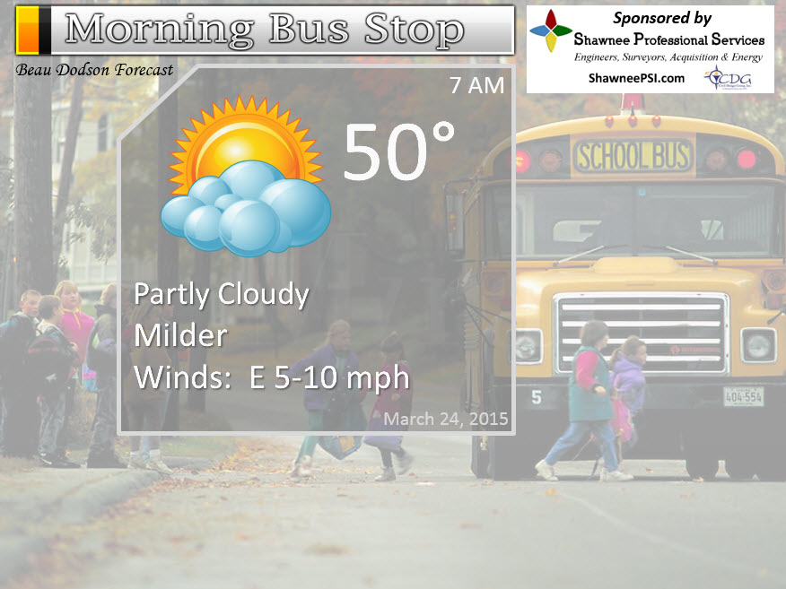
Morning School Bus Stop Weather – Partly sunny and mild. Temperatures mainly in the 50’s. Southerly winds at 10 mph.
—————————————————————————————-
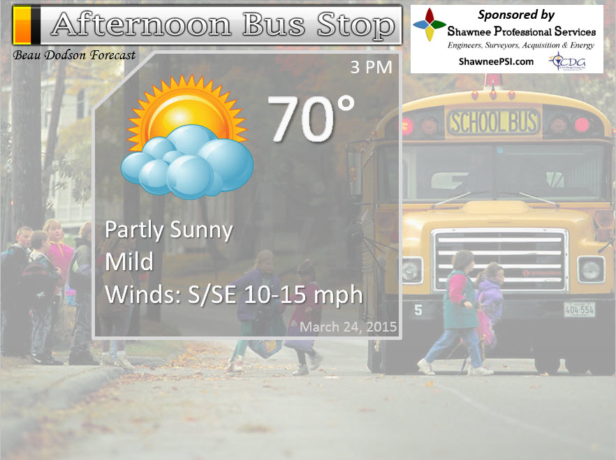
Afternoon School Bus Stop Weather – Partly sunny. A 30% chance for a shower or thunderstorm. Temperatures will be warm with highs in the upper 60’s to around 70 degrees. Cooler over northern counties.
Tuesday night – Partly cloudy. A chance for showers and thunderstorms. Dying line of storms should move in from the west. Weakening as they move further and further east. A few of the storms could produce strong and gusty winds over southeast Missouri and southern Illinois. Lows will be in the 50’s. Southerly winds at 10-15 mph. Gusty near a thunderstorm. My confidence in this part of the forecast verifying is medium
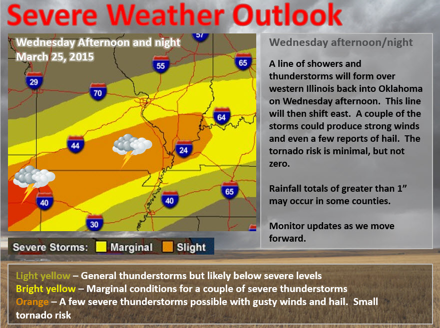
Wednesday – Partly sunny and warm. A few storms could develop during the day. Highs mostly in the upper 60’s to middle 70’s. Southerly winds at 10-20 mph. My confidence in this part of the forecast verifying is high
Wednesday night – Showers and thunderstorms likely. A few storms could produce gusty winds and even a couple of reports of hail. Tornado risk is small, but not zero. Locally heavy rain possible. Storms moving in from the west. My confidence in this part of the forecast verifying is high
Thursday – Cloudy with some morning showers and thunderstorms. Ending from west to east. Otherwise, cloudy. Cooler. Highs in the 50’s. My confidence in this part of the forecast verifying is medium

The School Bus Stop Forecast is brought to your by Shawnee Professional Services. For more information click here
Current Temperatures Around The Local Area


Don’t forget to check out the Southern Illinois Weather Observatory web-site for weather maps, tower cams, scanner feeds, radars, and much more! Click here

An explanation of what is happening in the atmosphere over the coming days…
Highlights
1. Warm/mild Tuesday (for some of us). Cooler north of the warm front vs south of the warm front. Some scattered showers and thunderstorms are possible today and this afternoon along and north of the warm front. This would mainly be along the Ohio River northward. Perhaps even better chances near I64.
2. A few showers and storms possible Tuesday night (dying line coming in from the west). The storms could hold together enough to produce strong winds, frequent lightning, and heavy downpours. Best chance for high winds with storms would be over parts of southeast Missouri and southern Illinois.
3. Some storms may form during the day on Wednesday afternoon. This will be well ahead of our main storm system.
4. Widespread thunderstorms Wednesday night into Thursday morning. Heavy storms possible (isolated severe risk).
5. Cold with temperatures into the 20’s by the weekend.
Radars
WEATHER RADAR PAGE – Click here —
I also set up a storm tracking page with additional links (use during active weather for quick reference)
Storm Tracking Tool Page
We have some active weather over the coming days.
Did you enjoy the nice temperatures today? Barb Waller posted this photograph from Murray, Kentucky. Looks nice!

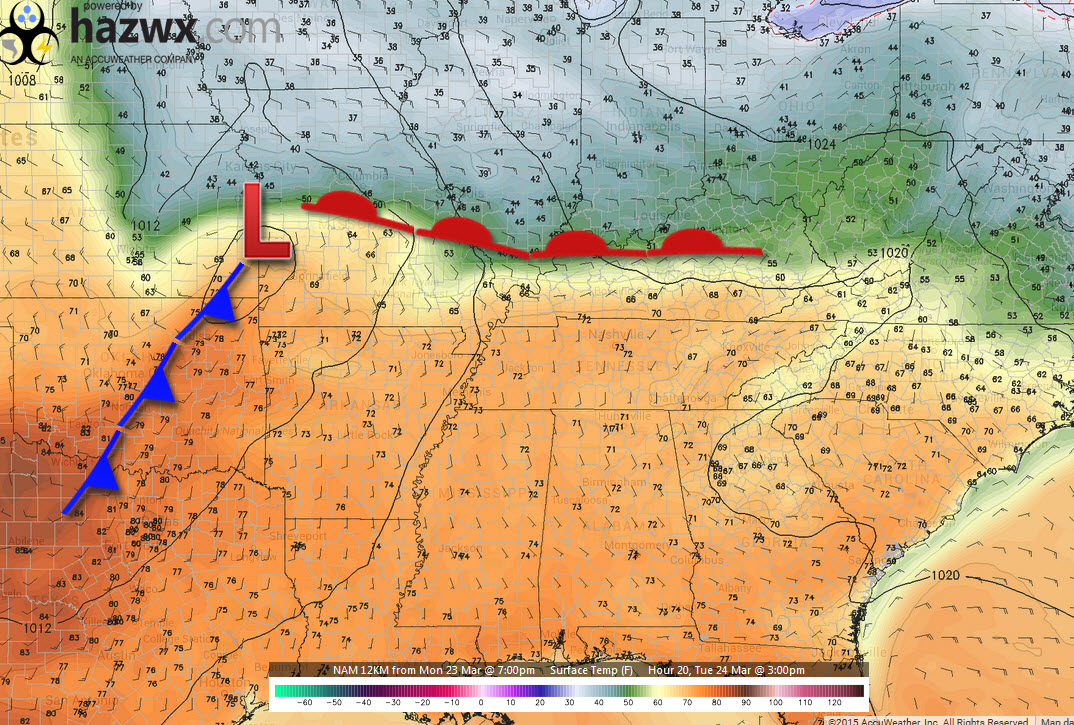
Today will bring more mild temperatures for the southern half of the region. Northern half will be a bit cooler. Warm front through the area. Cool to the north and warm to the south.
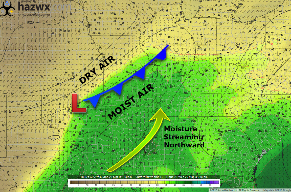
This is what that front looks like around 3 pm this afternoon. Note the cool air to the north? Warm air to the south. Map is from www.hazwx.com
Tuesday and Tuesday night…
We have a weak front that will approach our region tonight (Tuesday night). There will be widespread shower and thunderstorm development well to our west today. This area will shift east tonight and weaken as it moves away from the better instability and wind fields aloft (ingredients for thunderstorms).
Some showers and thunderstorms will move into southeast Missouri and southern Illinois this morning and this afternoon. Chances have increased a bit. I will put them at 30%-60% for those areas. Lesser chances south of the Ohio River. Better chances north of the Ohio River. Best chances will be near Randolph County, IL towards Mt Vernon, IL.
As mentioned above, a dying line of showers and storms will move into our area late tonight into Wednesday morning. By the time it reaches southeast Illinois and western Kentucky there might not be much left.
Best chances for showers and storms tonight will be over our western counties – from Poplar Bluff, MO towards Mt Vernon, Illinois. Along that line and west of that line. The time frame would likely be after 8 pm tonight. Some of these storms could produce strong and gusty winds, before they weaken.
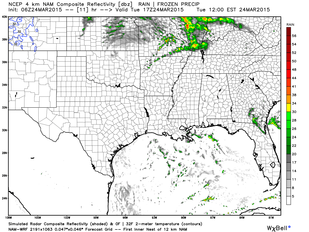
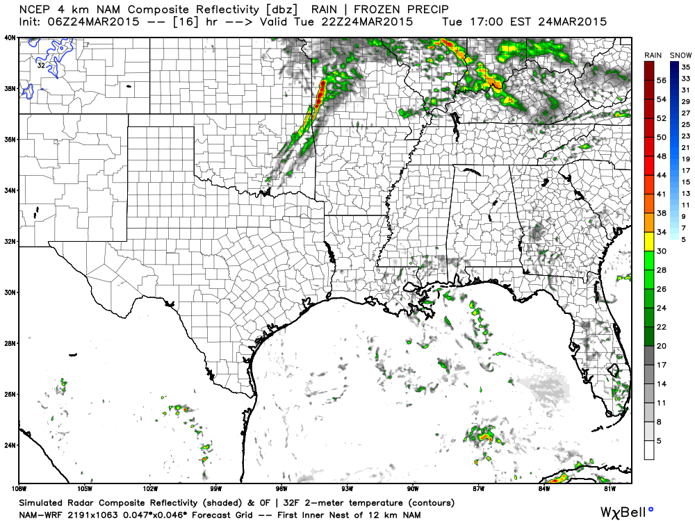
Here is the high resolution WRF model’s idea for today’s showers and thunderstorms. You can see it holds some together for our region (these will move in from the west). Images are from www.weatherbell.com
This first image is around 11 am this morning. The model is showing quite a few showers in our region. We will have to see how much of this activity holds together as it moves out of Missouri into Illinois. At the very least, there is a chance for some precipitation today in the area.
The NAM could be a little too far south with the activity. Just keep an eye on radar if you have concerns. Better chances the further north you travel in the region.
This is for around 4 pm this afternoon. Still some showers on the future-cast radar. You can also start to see a line of storms forming over western Missouri back into Oklahoma and Arkansas.
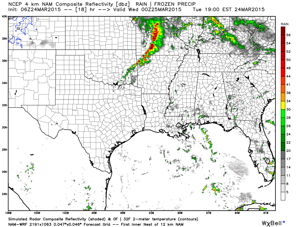
This next image (below) is for around 5 pm to 7 pm tonight (Tuesday night). You can see a few patchy showers remaining in our area. But, a line of heavy storms (some severe) forming well to our west. This is the line that will push into our region tonight. It will weaken, but could still produce some high winds. The best chance for some strong thunderstorms (with high winds) would be over southern Illinois and southeast Missouri. The further west you go…the better chance for a severe thunderstorm. Tonight’s risk is marginal, but not zero.
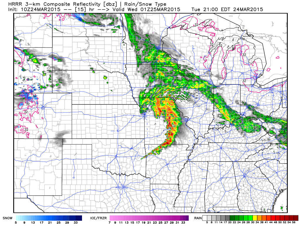
This is the future-cast radar for around 7 pm to 9 pm tonight (below). You can see that line of storms over Missouri. It is moving east at 25-35 mph.
As we push into the 1 am to 3 am time frame…you can see the dying line of storms over our area. It has weakened quite a bit by this point.
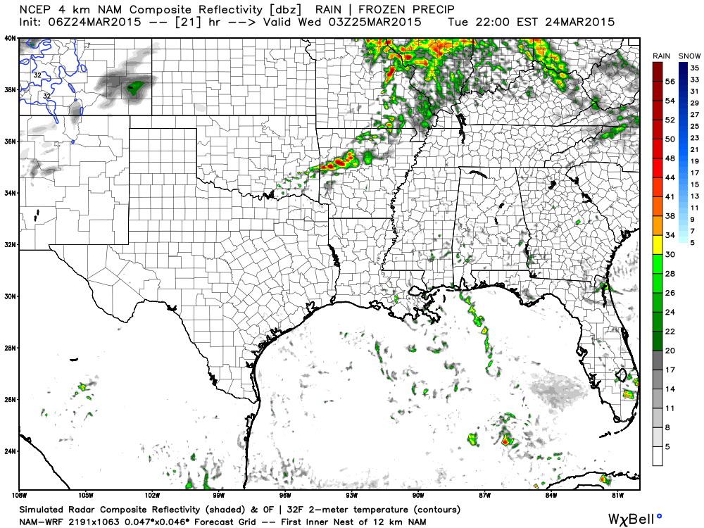
Bottom line…the shower and thunderstorm chances on Tuesday night don’t look overly impressive for most of the area. More so for our far western/northwestern counties. The line will be dying/weakening as it moves eastward. There could be a few reports of high winds with thunderstorms over southeast Missouri and maybe southern Illinois. Risk is marginal, but not zero.
Wednesday’s event…
A stronger system will move into our region late Wednesday and Wednesday night.
I want you to keep two things in mind
1. Timing of the event is important in determining whether the severe weather risk will go up a little bit or go down. Earlier the storms form the better chance for a couple of severe storms. If the storms form late then the risk goes down a bit.
2. Forecasting severe weather can be tricky. Like winter storms, severe thunderstorms can occasionally provide a few surprises. Always monitor the most up to date forecast information.
A line of showers and thunderstorms will develop, along a strong cold front, across parts of western Illinois into southwest Missouri and Oklahoma on Wednesday afternoon. The line will move east during the afternoon and evening hours. The line will intensify and could produce some severe weather during its early stages.
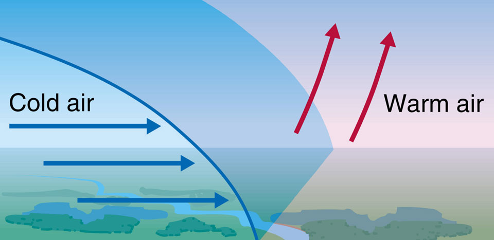
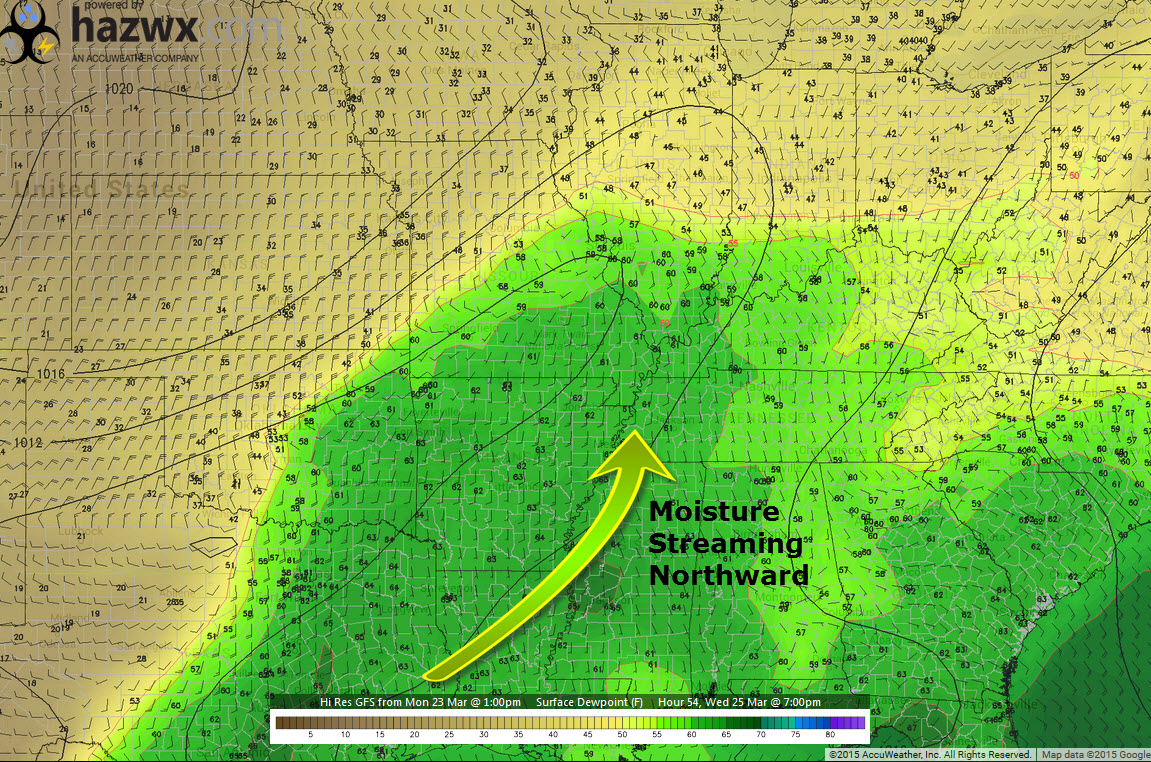
This is what that would look like on the dewpoint map. Dry air behind the front. Moist air ahead of the front. Cold front provides the lift. Boom – thunderstorms form.
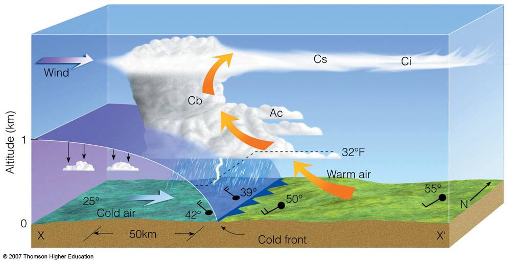
And a diagram of an advancing cold front. Bumps into the warm/moist air. This causes lift. Lift causes the clouds and storms to form.
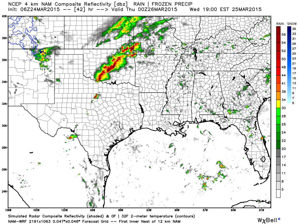
Here is what the high resolution WRF model is showing for Wednesday evening. You can see the squall line (line of heavy thunderstorms) forming in Missouri. It will move east.
This is the 6 pm to 8 pm future-cast radar view. Also note that there are a few showers and thunderstorms in our area…well ahead of the main line.
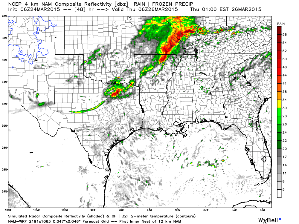
This future-cast radar (what radar might look like – remember, this is a model forecast) is for around 11 pm to 2 am time frame Wednesday night into Thursday morning. Images are from www.weatherbell.com
Those are some pretty heavy thunderstorms in our region. A few severe storms possible. The later we push into the night, the less the risk.
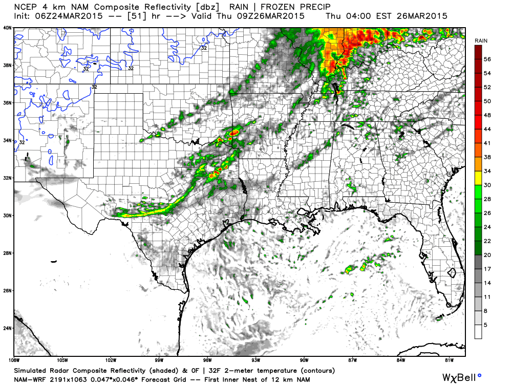
This is the future-cast radar view for around 2 am to 4 am Thursday morning. You can see showers and thunderstorms in our region. Locally heavy rainfall.
A severe weather watch may need to be issued for parts of our area on Wednesday afternoon and night. Severe thunderstorm and/or a tornado watch. Monitor updates.
A few warnings are possible. The main concern I have is for large hail and gusty winds. Small tornado risk.
The severe weather threat should diminish late Wednesday night. The later we move into the night…the less the chance for severe storms.
With that said, every severe weather event is unique. We will need to monitor the line of storms as it develops and moves eastward. The Storm Prediction Center could shift their severe weather outlook around a little bit, as we move forward. Check back often for updates here on the blog and on my Facebook page.
As storms push further and further east I suspect the severe weather risk will diminish. We would then transition to more of a heavy rain threat. Monitor updates as we move forward.
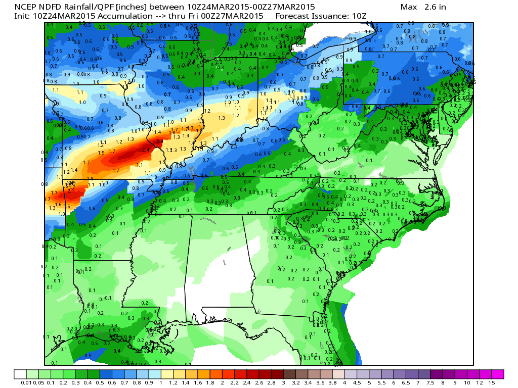
Locally heavy rain will be possible on Wednesday night into Thursday morning. Some spots will pick up more than an inch of rain.
Moisture will be streaming northward ahead of this system. Dew points will be on the rise rise rise over the coming 24-36 hours. For heavy rain and storms I like to see dew points of 58 to 60 or above. We should achieve those numbers with this particular system.
Showers and thunderstorms will diminish from west to east on Thursday morning and afternoon.
Much colder weather by Friday into the weekend.
Let’s look at a couple of more maps for the Wednesday afternoon and night event
One thing to keep in mind is the timing of the event. Some data brings thunderstorms into parts of southern Illinois and southeast Missouri by Wednesday afternoon. If this were to happen then the severe weather risk would go up a little bit. If the storms hold off (for my forecast counties) until later in the evening and overnight then the severe weather risk should be rather small, at any given location.
Let’s monitor the timing. I will update with the latest data as we draw closer to the event.
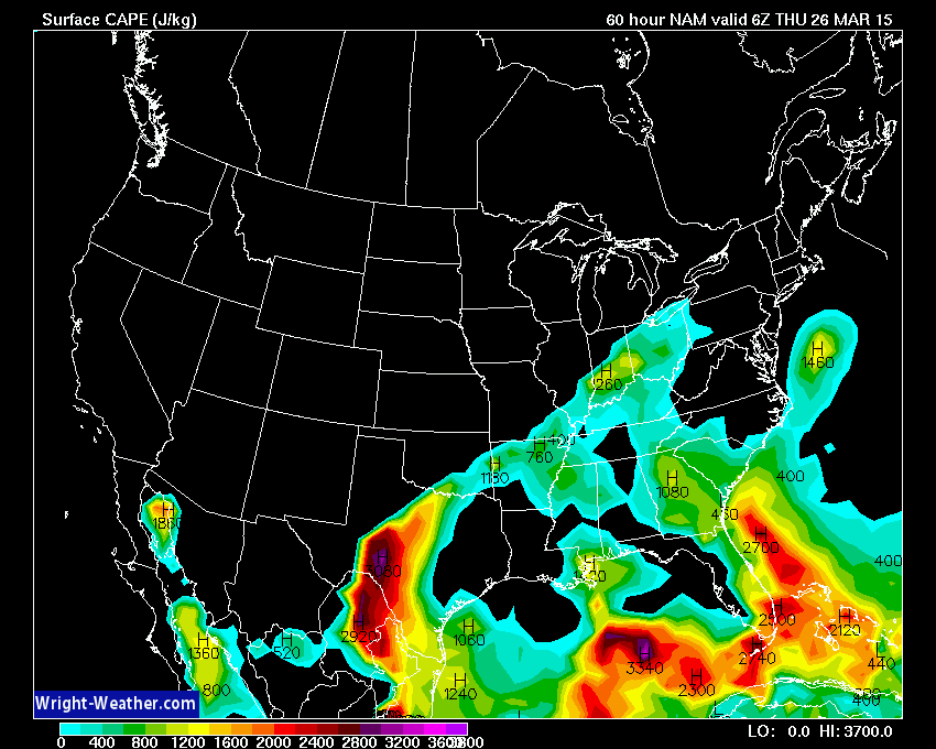
CAPE values – CAPE is basically available energy in the atmosphere. More information on CAPE can be viewed here – click here
You can see we have quite a bit of CAPE on Wednesday afternoon. The best lift doesn’t arrive until Wednesday evening or Wednesday night. This CAPE should be diminishing by the time the best lift arrives.
This is for the 2 pm through 5 pm time frame. CAPE values.
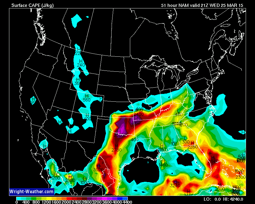
Now, look what happens late on Wednesday night. CAPE diminishes. CAPE (energy available for storms) goes down…severe weather risk goes down. Again, timing is everything with an event like this. Storms move in sooner and the risk goes up. Storms move in later then the risk goes down, a bit.
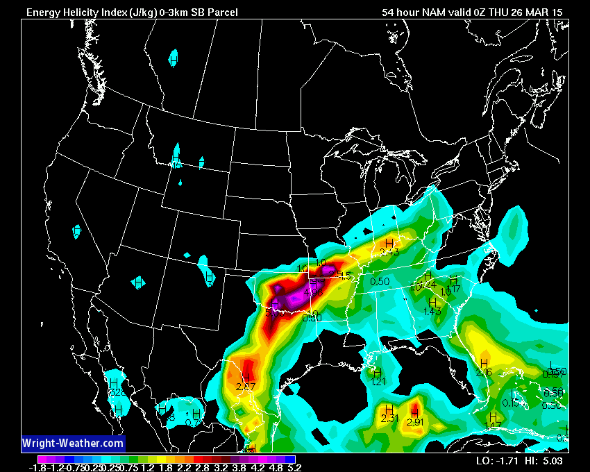
Let’s look at EHI values. I like to use EHI values for determining where the best risk for tornadoes or severe thunderstorms might occur. One more ingredient. You can’t use just one ingredient to make a severe weather forecast. There are a lot of factors that go into severe thunderstorm development.
More information (for you true to heart weather enthusiasts) about EHI values. Click here.
These are the Wednesday late afternoon values. You can see they spike over Missouri and Arkansas/Oklahoma.
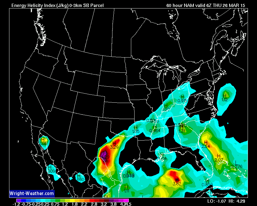
Now, let’s move ahead to the Wednesday night values. Again, what happens? They decrease. What does that mean? It means the risk for severe weather is on the decrease. Image is from wright-weather.com
Bottom line…
If storms move in quicker than forecast, on Wednesday afternoon, then I will be more concerned about a few storms producing high winds and large hail over southern Illinois and southeast Missouri. Perhaps even a little further east. If storms hold off until Wednesday night then perhaps a couple of storms will produce gusty winds and quarter size hail (again mostly over IL/MO).
As the night wears on we will see a transition from a severe weather concern to a heavy rain concern. Locally heavy rain will be possible over the region. Some places could experience rainfall totals over 1″. Some data is showing 2″ in spots.
Don’t forget to support our sponsors!

The severe weather outlook graphics have been updated. Typically the outlook area shifts around a bit from day to day. Keep this in mind. Check back often for the most up to date information.

Some thunderstorms tonight. Believe they will be in a weakening stage by the time them move into southern IL and western KY. Could be a few high wind reports over southeast MO and western IL.
Latest severe weather outlook for today
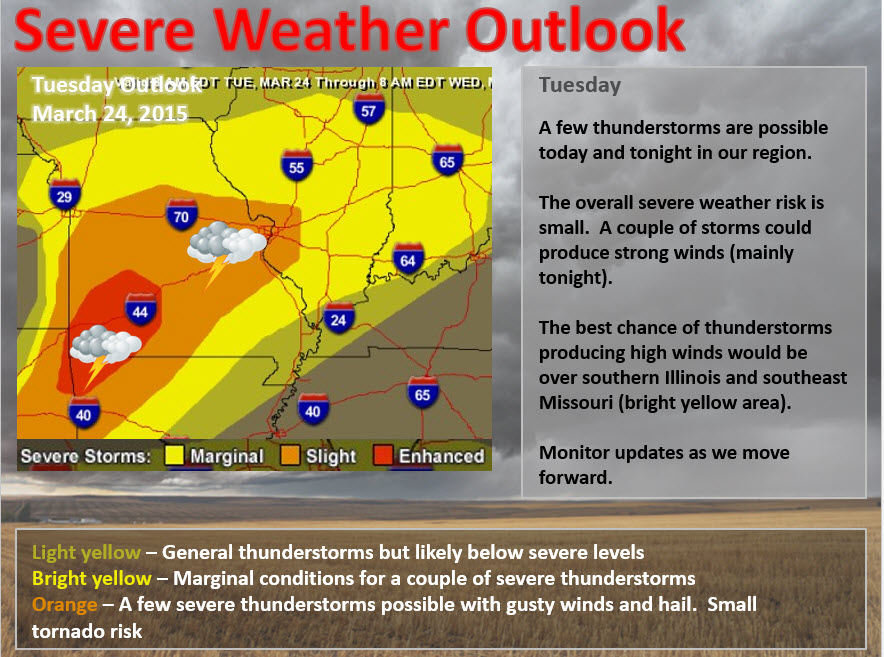
The main concern will arrive on Wednesday evening and night. A line of thunderstorms will approach our region from the west. This line of storms should produce locally heavy rain, lightning, gusty winds, and perhaps a few reports of hail. The overall severe weather risk at any given location is very small. A couple of severe storms may develop in the area. The greatest chance would be over southern Illinois and southeast Missouri. Monitor updates as we move forward.
Check out our sponsors! There are more on the right side bar of the page, as well. Be sure and let them know that you appreciate their sponsorship of the WeatherTalk daily weather bulletin.
How about a $5 meal deal? The DQ Grill and Chill (located across from Noble Park in Paducah, Kentucky) is the newest WeatherTalk Blog sponsor! A local business helping to sponsor the weather information that you have come to love so much.
Check out their Facebook page for specials, as well DQ Grill and Chill on Facebook


Premier Portable Buildings proudly serving our region. For more information click the above ad or here
They can also be found on this Facebook page
G&C Multi-Services out of Paducah, Kentucky. G & C Multi-Services is a service provider in Western Kentucky that provides industrial and commercial equipment fabrication, machine troubleshooting, repair and maintenance, and installation. They can custom fabricate steel, stainless, and aluminum products per customer specifications.
Visit their web-site here. Or click the ad below! Facebook page.


Wortham Dental Care located in Paducah, Kentucky. The gentle dentist. Mercury free dentistry. They also do safe Mercury removal. You can find Wortham Dental Care on Facebook, as well

Trover’s Equipment and Lawn Care – Family owned and operated! They are a dealer for Snapper, Simplicity, Snapper Pro, Bad Boy Mowers, and Intimidator Utility Vehicles. They are a Stihl and Dolmar power products dealer. They also are a dealer for Briggs & Stratton, Kohler gas & diesel engines, and Kawasaki engines. They service and repair just about any brand. You can find them on Facebook, as well
The School Bus Stop Forecast is brought to your by Shawnee Professional Services. For more information click here

Shawnee Professional Services & Civil Design Group have been providing Land Surveying, Engineering, Grant Administration and Acquisition services for the past 20 years. Currently Licensed in Illinois, Kentucky, Missouri, Indiana, and Tennessee; please contact Shawnee for any Land Surveying or Engineering needs. Shawnee’s company size allows them to devote individual attention to each client and to approach each project with the required thoroughness to successfully complete the project, large or small. Visit Shawnee’s website at shawneepsi.com for more information. Shawnee has offices in Paducah, KY, Vienna, IL and Benton, IL.
.

Here are the current river stage forecasts. You can click your state and then the dot for your location. It will bring up the full forecast and hydrograph.
Click Here For River Stage Forecasts…
Here are some current forecast hydrographs. These will be updated each day with new information.


Smithland Lock and Dam

Paducah, Kentucky Forecast Stage

Cairo, Illinois

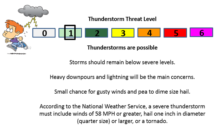
Can we expect severe thunderstorms over the next 24 to 48 hours? Remember that a severe thunderstorm is defined as a thunderstorm that produces 58 mph winds or higher, quarter size hail or larger, and/or a tornado.
Thunderstorm threat level is ONE through Tuesday night. A few storms possible. Locally heavy rain, gusty winds, lightning, and perhaps pea size hail with the most intense storms. The most intense storms would probably be over our western counties in southeast Missouri and perhaps western parts of southern Illinois – more towards Randolph County, Illinois down towards Carter County, Missouri.
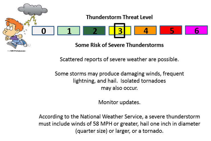
Wednesday Severe Weather Outlook – A few severe storms Wednesday evening and night. Monitor updates. Hail and gusty winds are the main concern. Main area of concern would be over southern Illinois and southeast Missouri. The further west you go in those areas…the greater the risk for a severe thunderstorms.
Thursday Severe Weather Outlook – Some strong storms possible early Thursday morning. Monitor updates
Friday Severe Weather Outlook – No severe storms
Saturday Severe Weather Outlook – No severe storms
Sunday Severe Weather Outlook – No severe storms
Wednesday’s Severe Weather Outlook. There will be a risk for a few severe thunderstorms. The main risk time would be on Wednesday night.

Will I need to take action?
Monitor updates concerning the potential for severe storms on Wednesday evening and night. Especially true for parts of Illinois and Missouri.

How much precipitation should we expect over the next few days?
I can’t rule out some stray showers and storms before Tuesday night, but a better chance of a dying line of showers and thunderstorms will arrive on Tuesday night.
The bulk of the precipitation, however, will arrive Wednesday evening into Thursday morning. This is when widespread showers and thunderstorms will occur.
As always when you have thunderstorms you can have a wide variance of precipitation totals. Keep that in mind. If a couple of thunderstorms move over the same areas then you can pick up a quick 1/2″ of rain (or more).
Overall, I think most people will have 0.50″-1.25″ of rain. Pockets of greater than 1.25″ will occur.

Some of the data indicates flurries possible late this week and weekend. For now, let’s focus on the fact that it is going to turn cold. Again. 🙂
Twenties likely for Saturday morning lows. Brrr

This section of the blog is speculative forecast information. Because it is past the range of what meteorologists can forecast accurately, it should be considered speculation. Anything past day 5 is considered a long range forecast.
Cold weather isn’t finished. Hope you kept the coats out!
A cold air mass, of arctic origins, will move into the region on Friday and Saturday. Thankfully it is now late March and now January. Otherwise, we would be dealing with temperatures into the single digits. But, since it is late March we can up those temperatures quite a bit.
Expect lows by Saturday morning to fall into the 20’s. Our roller-coaster ride in the temperature department will continue! Spring will be slow to start.

We have regional radars and local city radars – if a radar does not seem to be updating then try another one. Occasional browsers need their cache cleared. You may also try restarting your browser. That usually fixes the problem. Occasionally we do have a radar go down. That is why I have duplicates. Thus, if one fails then try another one.
If you have any problems then please send me an email beaudodson@usawx.com
WEATHER RADAR PAGE – Click here —
We also have a new national interactive radar – you can view that radar by clicking here.
Local interactive city radars include St Louis, Mt Vernon, Evansville, Poplar Bluff, Cape Girardeau, Marion, Paducah, Hopkinsville, Memphis, Nashville, Dyersburg, and all of eastern Kentucky – these are interactive radars. Local city radars – click here
NOTE: Occasionally you will see ground clutter on the radar (these are false echoes). Normally they show up close to the radar sites – including Paducah.

Regional Radar – Click on radar to take you our full radar page.


Regional Radar

Live Lightning Data – zoom and pan: Click here
Live Lightning Data with sound (click the sound button on the left side of the page): Click here

Day 1 Severe Weather Outlook from the Storm Prediction Center – Storm Prediction Center
What does thunderstorms, marginal, slight, enhanced, medium, and high risk mean? Click here

Current Severe thunderstorm and tornado watches from the Storm Prediction Center. The Storm Prediction Center is in charge of issuing watches. Our local National Weather Service Office in Paducah, Kentucky is in charge of issuing warnings.
Remember that a watch means that conditions are favorable for severe weather. Severe weather MIGHT develop over the coming hours. Watches normally last 4 to 8 hours. Monitor updates for possible warnings. A watch is a step below a warning.
A warning means to take immediate action to protect you and your family. Warnings usually last from 15 to 45 minutes. A warning means that a storm is moving into your area.
For additional watch information click here

![]()
Current WARNINGS (a warning means take action now). Click on your county to drill down to the latest warning information. Keep in mind that there can be a 2-3 minute delay in the updated warning information.
I strongly encourage you to use a NOAA Weather Radio or warning cell phone app for the most up to date warning information. Nothing is faster than a NOAA weather radio.


Color shaded counties are under some type of watch, warning, advisory, or special weather statement. Click your county to view the latest information.

Missouri Warnings

Illinois Warnings

Kentucky Warnings

Please visit your local National Weather Service Office by clicking here. The National Weather Service Office, for our region, is located in Paducah, Kentucky. They have a lot of maps and information on their site. Local people…local forecasters who care about our region.


Here is the official 6-10 day and 8-14 day temperature and precipitation outlook. Check the date stamp at the top of each image (so you understand the time frame).
The forecast maps below are issued by the Weather Prediction Center (NOAA).


The latest 8-14 day temperature and precipitation outlook. Note the dates are at the top of the image. These maps DO NOT tell you how high or low temperatures or precipitation will be. They simply give you the probability as to whether temperatures or precipitation will be above or below normal.


Who do you trust for your weather information and who holds them accountable?
I have studied weather in our region since the late 1970’s. I have 37 years of experience in observing our regions weather patterns. My degree is in Broadcast Meteorology from Mississippi State University and an Associate of Science (AS). I am currently working on my Bachelor’s Degree in Geoscience. Just need to finish two Spanish classes!
I am a member of the American Meteorological Society. I am a NOAA Weather-Ready Nation Ambassador. And, I am the Meteorologist for McCracken County Emergency Management.
I own and operate the Southern Illinois Weather Observatory.
There is a lot of noise on the internet. A lot of weather maps are posted without explanation. Over time you should learn who to trust for your weather information.
My forecast philosophy is simple and straight forward.
- Communicate in simple terms
- To be as accurate as possible within a reasonable time frame before an event
- Interact with you on Twitter, Facebook, and the blog
- Minimize the “hype” that you might see on television or through other weather sources
- Push you towards utilizing wall-to-wall LOCAL TV coverage during severe weather events
I am a recipient of the Mark Trail Award, WPSD Six Who Make A Difference Award, Kentucky Colonel, and the Caesar J. Fiamma” Award from the American Red Cross. In 2009 I was presented with the Kentucky Office of Highway Safety Award. I was recognized by the Kentucky House of Representatives for my service to the State of Kentucky leading up to several winter storms and severe weather outbreaks.
If you click on the image below you can read the Kentucky House of Representatives Resolution.

I am also President of the Shadow Angel Foundation which serves portions of western Kentucky and southern Illinois.
Many of my graphics are from www.weatherbell.com – a great resource for weather data, model data, and more


This blog was inspired by ABC 33/40’s Alabama Weather Blog – view their blog
Current tower cam view from the Weather Observatory- Click here for all cameras.

Southern Illinois Weather Observatory

The Weather Observatory

Southern Illinois Weather Observatory
WSIL TV 3 has a number of tower cameras. Click here for their tower camera page & Illinois Road Conditions

Marion, Illinois
WPSD TV 6 has a number of tower cameras. Click here for their tower camera page & Kentucky Road Conditions & Kentucky Highway and Interstate Cameras

Downtown Paducah, Kentucky
Benton, Kentucky Tower Camera – Click here for full view

Benton, Kentucky

I24 Paducah, Kentucky

I24 Mile Point 9 – Paducah, KY

I24 – Mile Point 3 Paducah, Kentucky

You can sign up for my AWARE email by clicking here I typically send out AWARE emails before severe weather, winter storms, or other active weather situations. I do not email watches or warnings. The emails are a basic “heads up” concerning incoming weather conditions.