
9 AM Updated the day 3 severe thunderstorm outlook map
We have some great sponsors for the Weather Talk Blog. Please support them when you have the opportunity.
Milner and Orr Funeral Home and Cremation Services located in Paducah, Kentucky and three other western Kentucky towns – at Milner and Orr they believe in families helping families. You can find Milner and Orr on Facebook, as well.
![]()

This forecast update covers far southern Illinois, far southeast Missouri, and far western Kentucky. See the coverage map on the right side of the blog.
Remember that weather evolves. Check back frequently for updates, especially during active weather.
The forecast numbers below may vary quite a bit across the region. These are averages.
Monday – Mix of sun and clouds. Quite a few clouds over the coming days. Chance for a light shower over northern and northeastern counties. Mild temperatures. Morning temperatures will start in the 30’s and near 40 but rise into the 50’s and 60’s during the afternoon. Warmest temperatures will be over far southern Illinois, southeast Missouri, and west KY/TN. A bit cooler (the 50’s) for far northern counties in the area. Winds from the east at 10 mph with gusts to 15 mph. Winds shifting more southerly late in the day. My confidence in this part of the forecast verifying is high
Morning School Bus Stop Weather – Partly cloudy and cool. Temperatures around 40 degrees. Chances of schools being delayed because of the weather, zero.
—————————————————————————————-
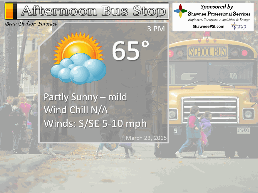
Afternoon School Bus Stop Weather – Partly cloudy and mild. Temperatures mostly in the 60’s.
Monday night – Some clouds. Small chance for a shower. Mild with lows mostly in the 40’s. South/southwest winds at 10 mph. My confidence in this part of the forecast verifying is medium
Tuesday – Partly sunny and mild/warm and more humid. A chance for a shower or thunderstorm far northern and northwestern counties – more towards St Louis area vs our local area. But, a few showers/storms could stray south and east a bit. Another chance for a shower/storm over northeastern counties – closer to IL/IN border, as well. Small chances overall. Will monitor trends on the data. Overall, most of the area should be dry. Highs well into the upper 60’s to middle 70’s. Southerly/southwesterly winds will pick up at 10-20 mph. Gusty at times. My confidence in this part of the forecast verifying is medium
Tuesday night – Becoming cloudy. Mild. A chance for scattered showers and thunderstorms. Broken line of storms after midnight, should be weakening as they move eastward. Lows in the 50’s with southerly winds at 10-20 mph. Gusty near any thunderstorms. My confidence in this part of the forecast verifying is medium
Wednesday – Partly sunny. A slight chance for thunderstorms redeveloping late in the day. Highs well into the 60’s and perhaps lower 70’s. Winds becoming south/southwest at 10-20 mph. My confidence in this part of the forecast verifying is medium
Wednesday night – Cloudy with showers and thunderstorms becoming likely. Heavy rain, gusty winds, and small hail possible with the most intense storms. Mild with lows in the 50’s. My confidence in this part of the forecast verifying is medium
Thursday – Showers and thunderstorms likely during the morning. Ending from west to east.


The School Bus Stop Forecast is brought to your by Shawnee Professional Services. For more information click here
Current Temperatures Around The Local Area


Don’t forget to check out the Southern Illinois Weather Observatory web-site for weather maps, tower cams, scanner feeds, radars, and much more! Click here

An explanation of what is happening in the atmosphere over the coming days…
Highlights
1. Unsettled weather over the coming days
2. Best chance for widespread showers and thunderstorms will be Wednesday afternoon and especially Wednesday night into Thursday morning. Locally heavy rain and thunderstorms. Monitor updates.
3. Much colder by the weekend with well below normal temperatures (20’s are possible for overnight lows). I know some of you have been itching to plant some seeds. But, we may not be finished with below freezing temperatures. I keep saying that 🙂
Radars
WEATHER RADAR PAGE – Click here —
I also set up a storm tracking page with additional links
Storm Tracking Tool Page
Warm air will be the rule over the coming days. We will have a few fronts to monitor. A warm front today and tonight (Monday) will slowly move northward through our region. Along and north of the front there could be some showers and thunderstorms. Does not appear to be widespread in our local counties.
The warm front will be the focus for some additional thunderstorms on Tuesday. Then a cold front will also move east out of Missouri on Tuesday evening/night. Showers and thunderstorms will be possible along this front, as well. Best chances will be over our western and northwestern counties. Overall the showers and storms will be weakening as they push east.
The front will shift eastward on Tuesday night and move through our entire area by Wednesday morning. Showers and some thunderstorms may accompany the front. Again, it appears the thunderstorms will be weakening as they push into our local area. A few severe thunderstorms will be possible to our west in Missouri (see detailed discussion below). This will likely be outside of my forecast counties. But, I will monitor for any changes.
Another cold front will approach the area on Wednesday afternoon and Wednesday night. This front will have the best chances for widespread showers and thunderstorms for our region. Locally heavy rain will be possible. Rainfall totals generally will be in the 0.50″-1.25″ range. Pockets of 1.25″-2.00″ not impossible.
There will be a chance of a few strong to severe thunderstorms near our area on Wednesday evening and night. Perhaps the best chances will be southern Missouri into Arkansas/Oklahoma. This might include the Poplar Bluff area and then into the Missouri Bootheel and northwest Tennessee. Monitor updates as we move forward. Severe weather is like winter weather…usually forecasters don’t have a handle on it until the day of the event.
Much colder air returns by Friday into the weekend. Some freezing temperatures can’t be ruled out. Keep the coats out just a bit longer.
Let’s take a look at the future-cast weather maps for the coming days. I will walk you through how I suspect everything will unfold. There are some timing differences in the data as far as the arrival time for showers and storms on Wednesday night into Thursday morning. There is currently a 3-6 hour time difference in the data. Some of the models bring precipitation in faster than other models. Plenty of time to fine tune the forecast as we move forward.
This is the GFS model (below). It does okay in the 3-5 day range. Not so great in the shorter range.
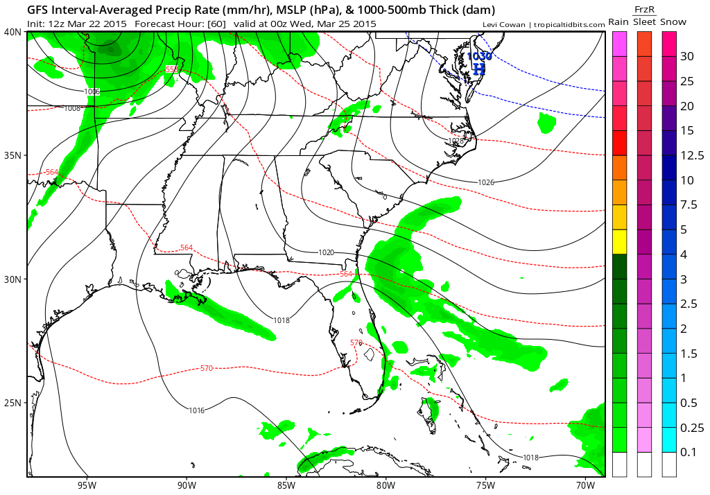
This first map is the 11 am to 1 pm time frame on Tuesday. You can see some showers and thunderstorms (green) over our far northwest counties and northeast counties. This would be along a warm front. Usually along and north of a warm front you can expect showers and thunderstorms to develop. You can also see the trailing precipitation back into Oklahoma. That would be the cold front. Precipitation usually occur along and ahead of cold fronts (sometimes behind them, as well).
Here is an example of a warm front. Warm air rises up and over the front. As the warm air rides over the cooler air at the surface you end up with clouds and some precipitation. Areas south of the warm front normally remain dry (until another lifting mechanism arrives, such as a cold front)
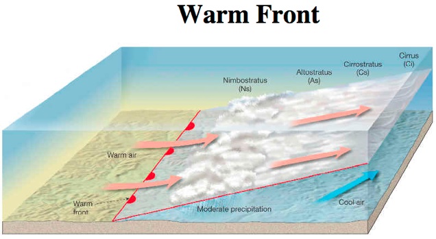
On the image below, the warm front would be located from central Missouri into southern Indiana. The green to the north of the front would be the clouds and rain/storms. Again, this is around 11 am to 1 pm on Tuesday (below)
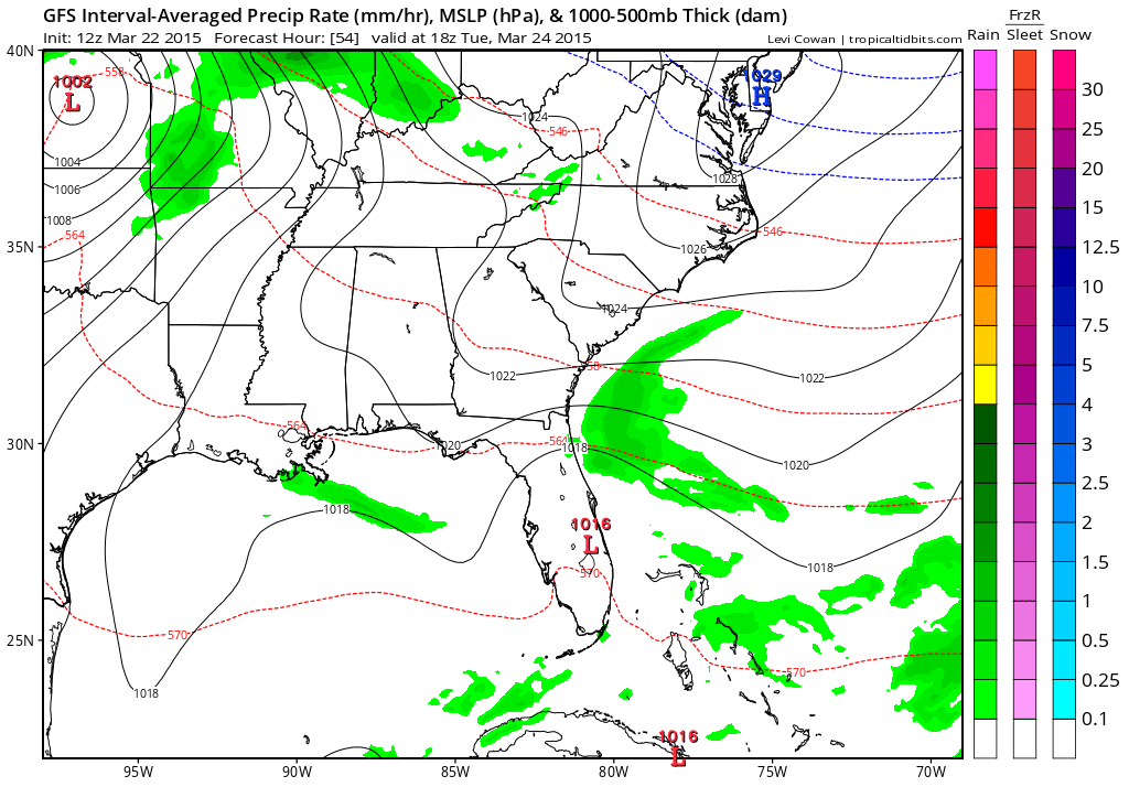
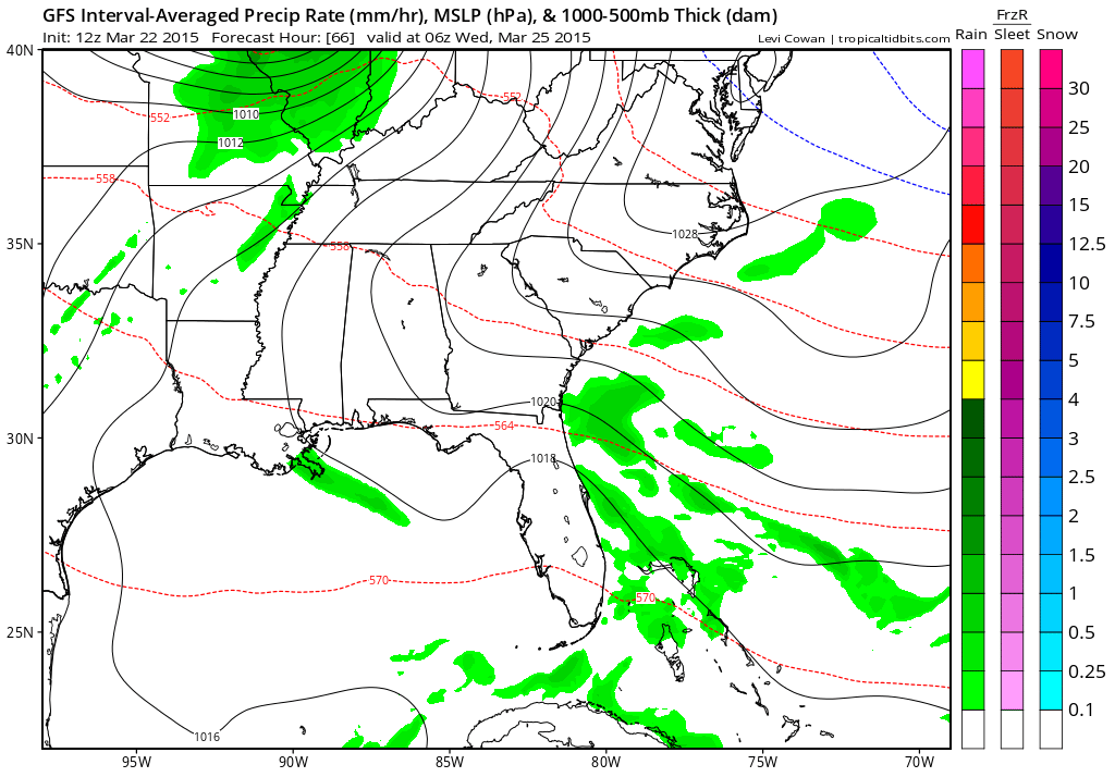
Tuesday evening weather map (below). Low pressure just off the map in northern Missouri and Iowa (see the circle of isobars?). Trailing cold front with showers and possibly some severe thunderstorms in western and central Missouri. This front will move east on Tuesday night. Thankfully the line of storms will weaken as it approaches our local counties. Will need to watch the far western and northwestern half of the region for a few strong storms. Will have to see how much of that line holds together. The line should be weakening as it moves east.
Example of a cold front – see the green trailing back over western Missouri into Oklahoma?
Tuesday night around 11 pm to 1 am Wednesday morning (below). Some of the showers and thunderstorms may track into our local area. The storms should remain below severe levels on Tuesday night and Wednesday morning. Lightning and a heavy downpours possible.
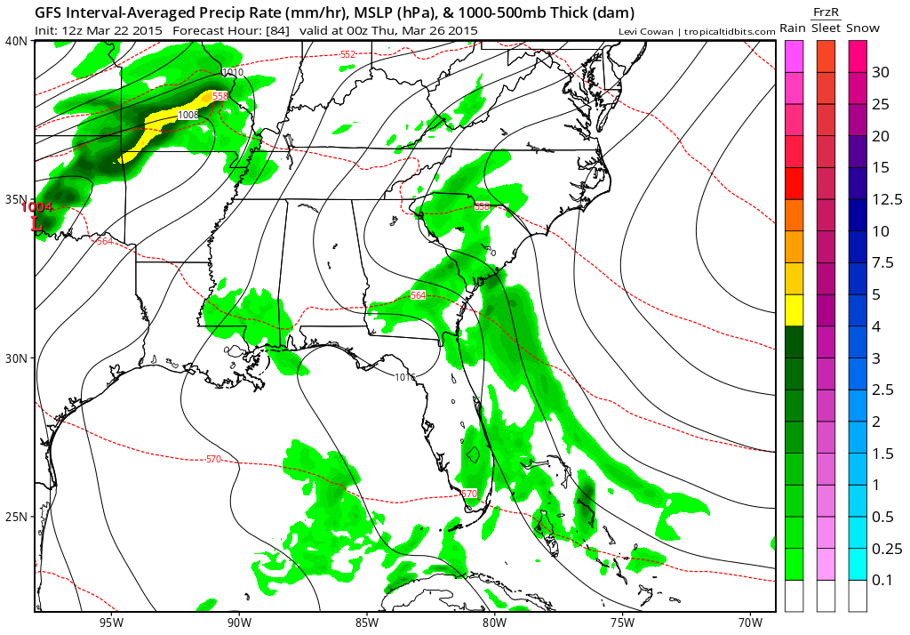
Then another cold front approaches on Wednesday evening (below). Showers and thunderstorms should rapidly develop across parts of western Illinois down into Missouri and Arkansas. This area of precipitation will shift east overnight. This is when our region could experience some heavy rain and possibly even strong thunderstorms. I believe the severe weather risk will be minimal, not zero – but minimal. Perhaps the best chance for some severe storms would be over southern Missouri into Arkansas/Oklahoma. Monitor updates.
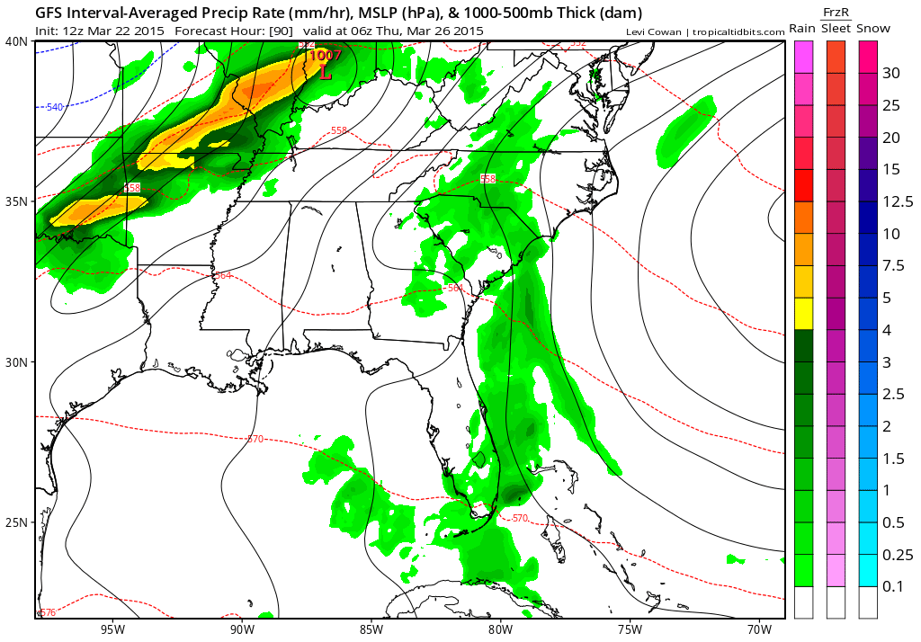
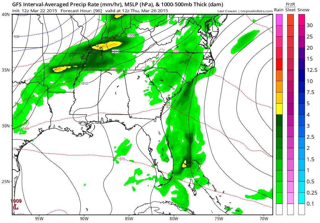
Wednesday night 11 pm to 1 am Thursday morning (below). Weather map shows widespread showers and thunderstorms in our area. The orange and yellow represents some heavy downpours.
This is the Thursday morning weather map (below). Showers and thunderstorms may still be in our area at that time. Will need to see just how fast the front moves out. It might stall over our area. If that occurs then lingering rain chances will be in the forecast into Thursday afternoon and maybe Friday (esp eastern and southern counties)
Let’s look at some of the severe weather parameters for this event
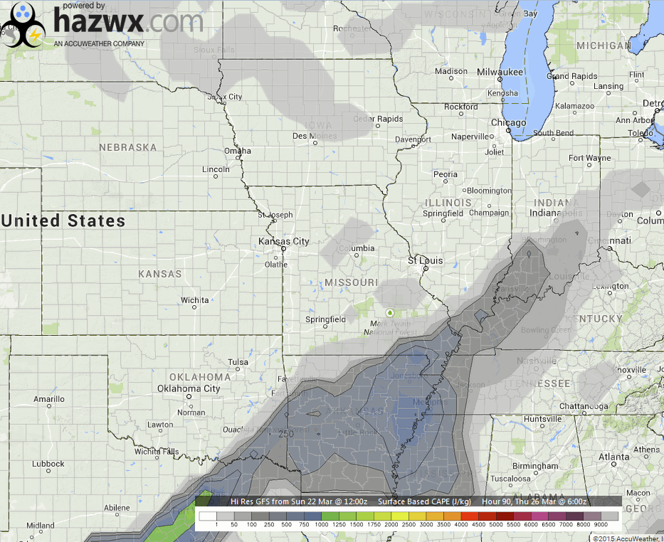
Let’s look at CAPE values on Wednesday. CAPE is basically available energy in the atmosphere. More information on CAPE can be viewed here – click here
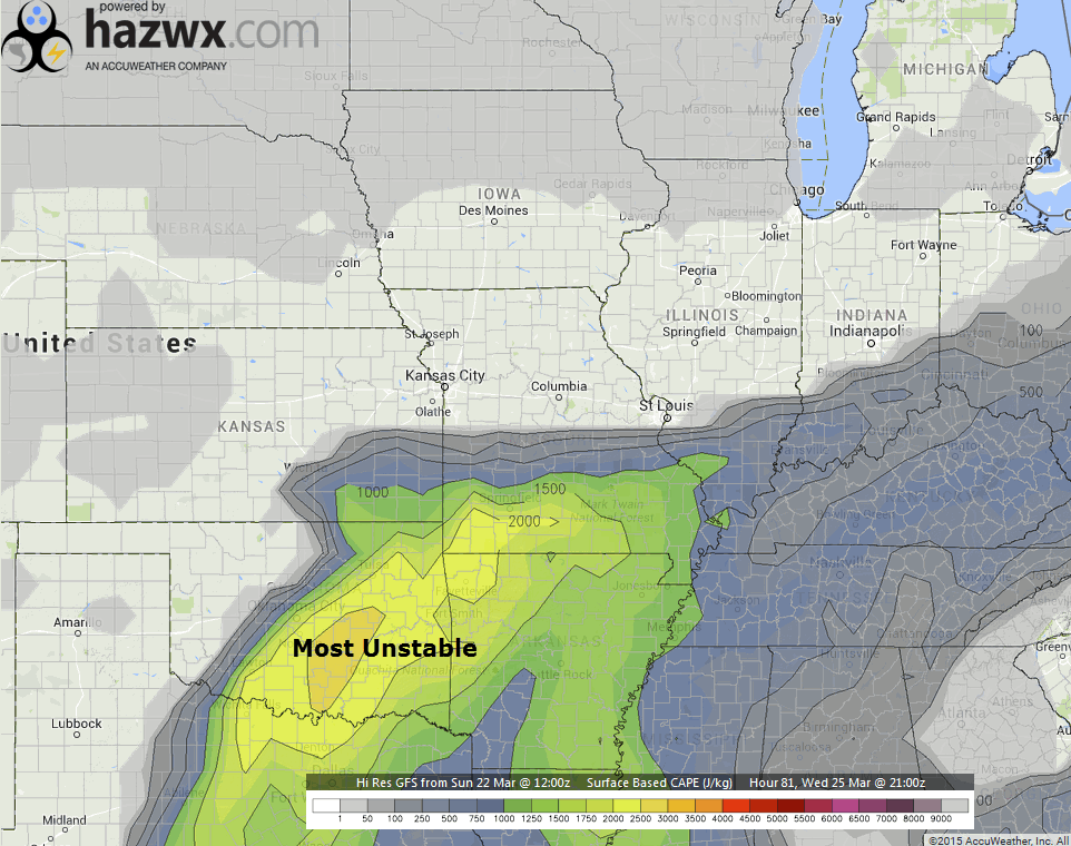
For severe weather (during late March) I look for CAPE values of 800+. The highest CAPE numbers are located over southern Missouri and Arkansas on Wednesday afternoon and evening. As the evening wears on the CAPE values will drop.
These are the CAPE values around 3 pm on Wednesday afternoon. Some decent numbers over southern Missouri into Arkansas. A severe thunderstorm or tornado watch may need to be issued for the areas with the highest CAPE numbers. Likely that would end up over southern Missouri into Arkansas and parts of Oklahoma.
These images are from hazwx.com
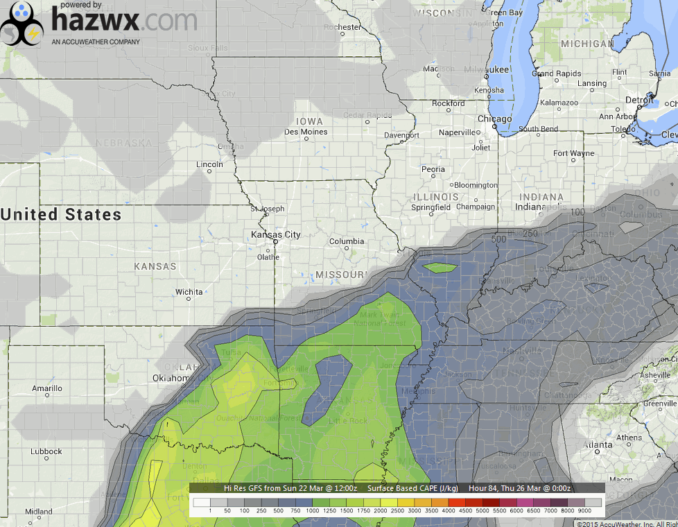
As we move forward into the evening hours…this is around 7 pm on Wednesday evening (below). Notice the brighter colors/higher values are waning.
Later in the evening…this is around midnight (below). See how the CAPE values are decreasing? This is partly because we are losing the heating of the day. Part of the CAPE formula depends on surface temperatures. Normally CAPE values drop at night (not always, but usually). The less CAPE means the less energy available for thunderstorms to feed on.

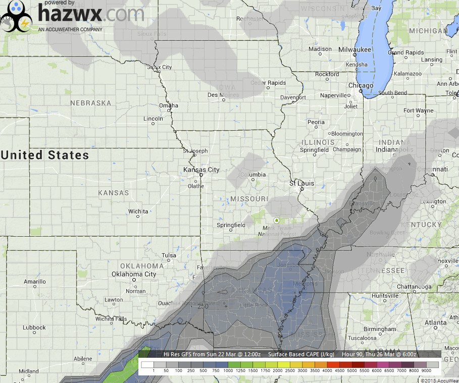
Now let’s move ahead to around 3 am on Thursday morning. You can still see some CAPE in our area, but it isn’t much. This leads me to believe the severe weather threat will be minimal. Heavy rain will, however, be possible.
And finally, around 7 am on Thursday morning. The front has slowed down. Some CAPE values in the 100 to 400 range over our local counties. Not much. Again, if this was showing 800-1500 CAPE then I would be more concerned.
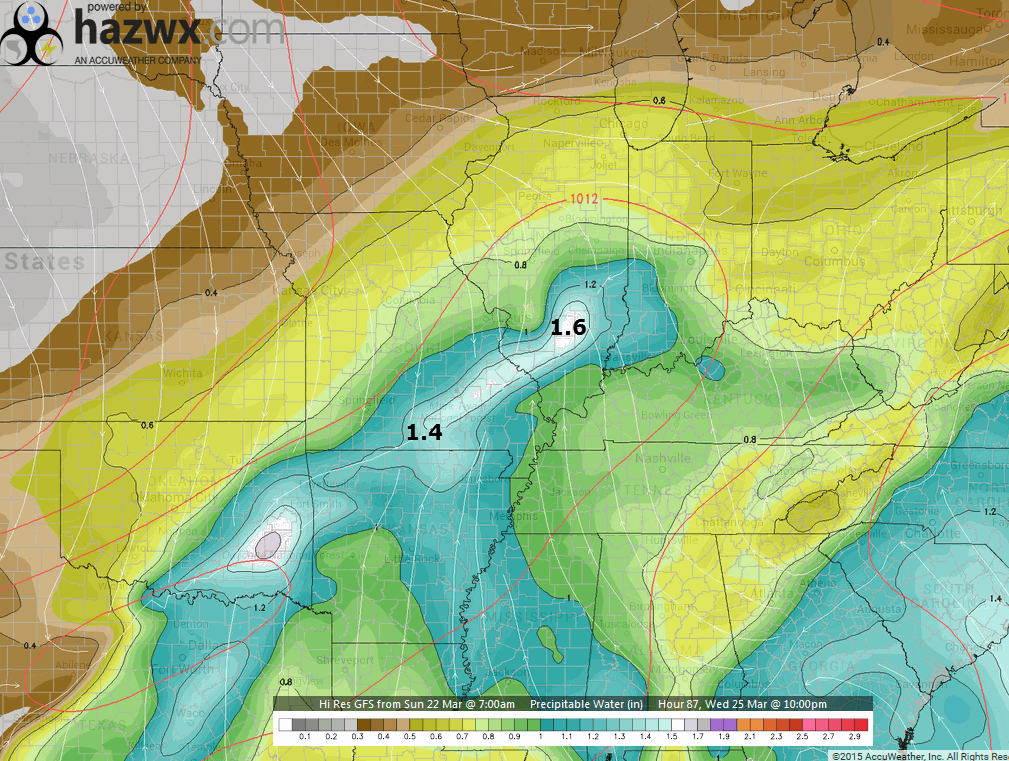
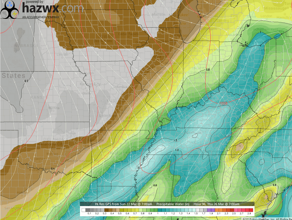
Let’s look at PWAT values. Some of you who have been with me for awhile will know what that word means. PWAT is precipitable water values. How much moisture is in the entire atmospheric column. If you were to wring all the moisture out in the column how much would you have. Maps are showing 1″-1.4″. Those are decent numbers for the middle of March (not extreme). Some locally heavy downpours are possible along the front. Most likely this would occur during Wednesday late afternoon and especially Wednesday night into Thursday morning.
Let’s track the highest PWAT numbers as they move west to east.
This is the Wednesday evening map (8 pm to 10 pm). See the higher numbers pooling along the cold front? That tongue of blue represents higher PWAT values. The highest numbers will correlate with the heavier rain.
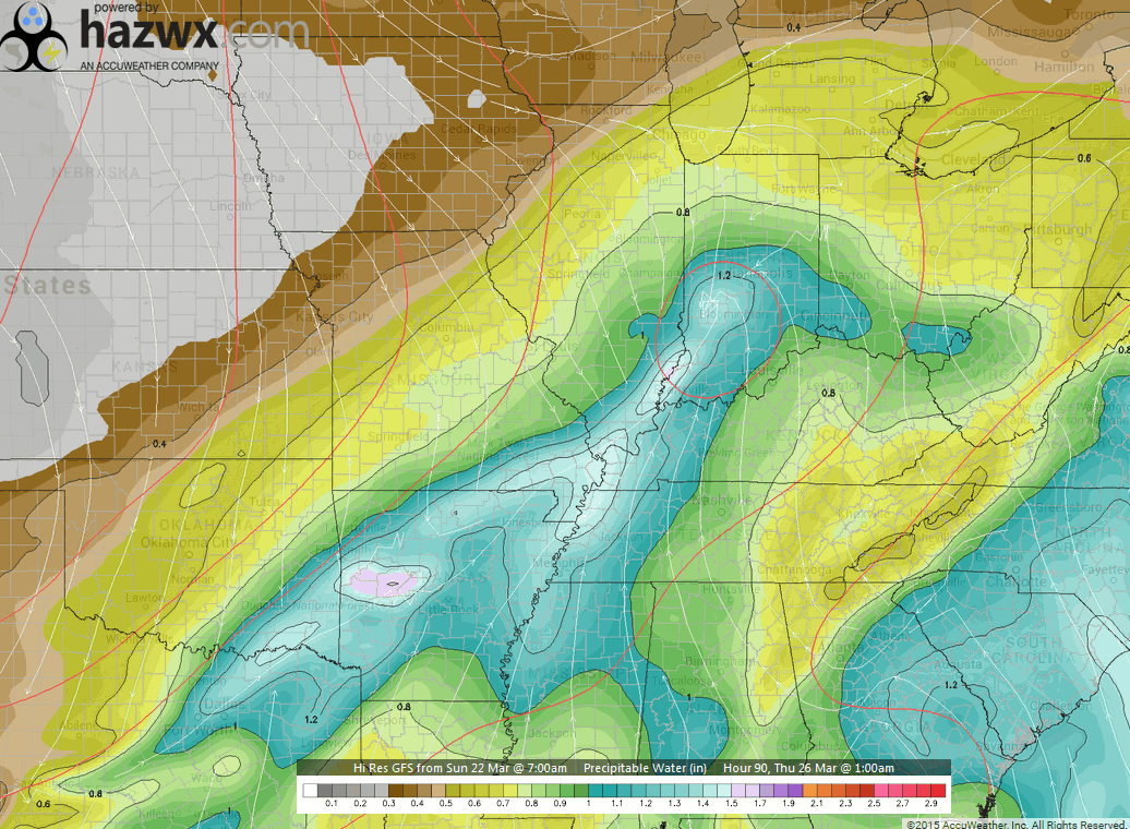
Let’s move forward into the overnight hours. The higher PWAT values will track east. This is the 11 pm to 2 am map. If the GFS model is correct then some moderate to heavy rain will likely occur over our region on Wednesday night.
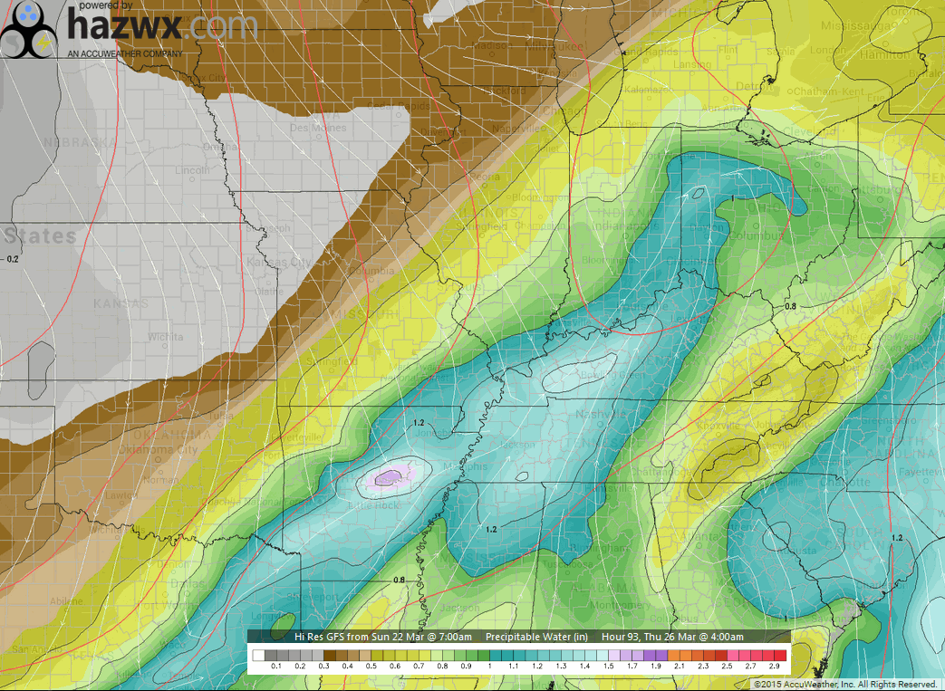
By 2 am to 4 am you can see the highest PWAT values are moving into Indiana, Kentucky, and Tennessee.
By 7 am you can see the higher PWAT values tracking even further east. The front may stall out somewhere near our region. If the front does stall then rain may linger longer into the day on Thursday.
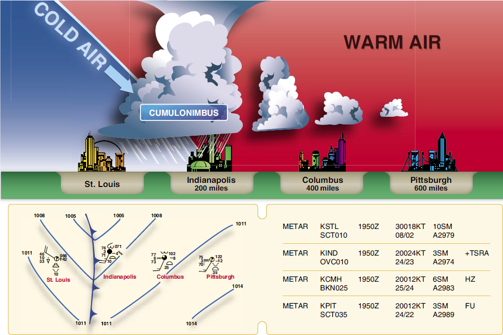
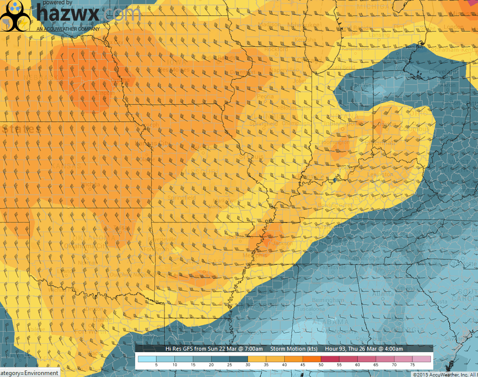
Let’s take quick look at storm motion. Storms should be moving from the west to the east at speeds of 40-55 mph. See how the wind barbs are pointing from the west? That means storms are moving from west to east. Each line is 10 knots. If the wind barb has 3 lines on it then that means 30 knots.
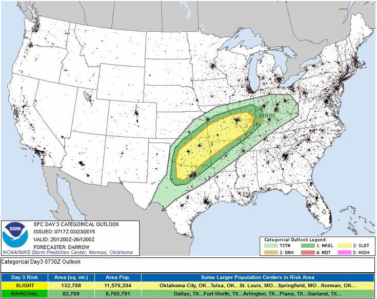
Let’s take a look at the latest Storm Prediction Center’s severe weather outlooks. The Storm Prediction Center, located in Oklahoma, are the forecasters who issue severe weather outlooks, severe thunderstorm watches, and tornado watches. Get used to seeing these maps. I am sure there will be many of them over the coming months.
This is the Tuesday severe weather outlook. The light green is where a few sub-severe thunderstorms are possible. General thunderstorms, in other words. The dark green and yellow zone is where a few severe storms will be possible.
The orange area is the greatest risk zone for a few severe thunderstorms. The bright yellow area will experience a marginal risk. Maybe a few storms with high winds and hail. The lightest yellow color represents general thunderstorms. General thunderstorms are thunderstorms that should remain below severe levels. Lightning, heavy rain, and gusty winds can occur with general thunderstorms, of course.
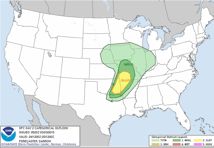
Wednesday’s severe weather outlook has been updated. The SPC nudged the risk zone a bit further north and east, as expected.
This means that some of our counties are now in a risk zone (the yellow zone). I believe the risk is small, overall…for our area. A few storms could produce gusty winds and hail.
The dark green zone is where conditions will be marginal for a severe thunderstorm or two. Small risk, overall. The lighter green around the darker olive green would be where general thunderstorms are possible (below severe levels).
Don’t forget to support our sponsors!

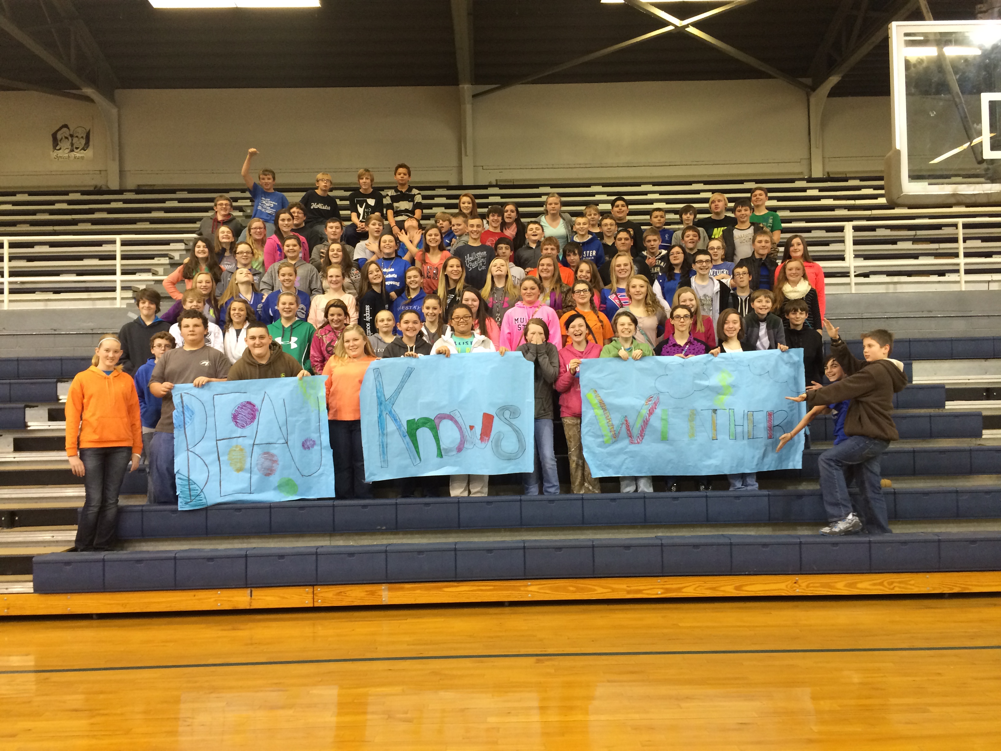
This question is from Clowey Jones from Crittenden County Middle School in Marion, KY (Home of the Rockets)!
What college did you go to? For how long? What classes did you have to take?
Great question, Clowey.
I attended Jefferson Grade School in Massac County, Illinois. It was at Jefferson Grade School that my interest in weather began to flourish. My fourth grade teacher, Millege Bremer, was a real inspiration for me. I used to draw weather maps on my school papers. He pulled me aside one day and asked me what in the world all of the drawings were supposed to be. I told him that they were supercell thunderstorms! From that day on he told me that I would grow up to be a weatherman. And, so I did.
I then attended Massac County High School. While at MCHS my interest in weather continued to grow. The school principal would let me watch The Weather Channel in the office (over my lunch break). Everyone would ask me for the weather forecast. Forecasting snowstorms was the most fun. Although, if I didn’t get the forecast right there were quite a few unhappy students. lol I guess they didn’t do their homework…in anticipation of snow – oops.
From there I attended Shawnee Community College in Ullin, Illinois. I took a variety of classes. Quite a bit of math and science, of course.
Once I finished at Shawnee Community College I took a few years off from school. I don’t recommend doing that! But, my life journey took me down some other paths (at least for awhile).
I went back to school in the early 2000’s. I attended Mississippi State University and signed up for their broadcast meteorology program. That program took about 2 years to complete. The program consisted of a lot of math and science classes. I am currently working on my Bachelor’s in Geo-Science degree. I need to finish two Spanish classes. Once I finish those 2 classes then I will complete another degree.
If you are thinking about going into the meteorological field then I suggest you study a lot of math and science. Heavy on the math. Do not skimp on the math. Science, as well! Did I mention that you should take a lot of math classes? 🙂
You can read more of my credentials towards the bottom of the blog.
I hope that answers your question!
Stay in school. Study hard. Follow your passion.
Here is the school photo that was sent to me by Tiffany Blazina and this is the 7th grade class.
Mattea Meadows, Language Arts teacher, led this project (of questions).

Main concern is going to be thunderstorm chances on Wednesday afternoon and Wednesday night. A strong cold front will approach our region during this time period. Showers and thunderstorms will break out along the front (and even behind this particular front). Some of the thunderstorms could approach severe levels or reach severe levels in or near our region. Best dynamics and parameters for severe weather will be over our southwest counties. That would include areas like Poplar Bluff, MO into the Missouri Bootheel and perhaps northwest Tennessee.
Locally heavy rain will be possible over our region, as well.
Monitor updates, as we move forward and more data becomes available.
Check out our sponsors! There are more on the right side bar of the page, as well. Be sure and let them know that you appreciate their sponsorship of the WeatherTalk daily weather bulletin.
How about a $5 meal deal? The DQ Grill and Chill (located across from Noble Park in Paducah, Kentucky) is the newest WeatherTalk Blog sponsor! A local business helping to sponsor the weather information that you have come to love so much.
Check out their Facebook page for specials, as well DQ Grill and Chill on Facebook


Premier Portable Buildings proudly serving our region. For more information click the above ad or here
They can also be found on this Facebook page
G&C Multi-Services out of Paducah, Kentucky. G & C Multi-Services is a service provider in Western Kentucky that provides industrial and commercial equipment fabrication, machine troubleshooting, repair and maintenance, and installation. They can custom fabricate steel, stainless, and aluminum products per customer specifications.
Visit their web-site here. Or click the ad below! Facebook page.


Wortham Dental Care located in Paducah, Kentucky. The gentle dentist. Mercury free dentistry. They also do safe Mercury removal. You can find Wortham Dental Care on Facebook, as well

Trover’s Equipment and Lawn Care – Family owned and operated! They are a dealer for Snapper, Simplicity, Snapper Pro, Bad Boy Mowers, and Intimidator Utility Vehicles. They are a Stihl and Dolmar power products dealer. They also are a dealer for Briggs & Stratton, Kohler gas & diesel engines, and Kawasaki engines. They service and repair just about any brand. You can find them on Facebook, as well
The School Bus Stop Forecast is brought to your by Shawnee Professional Services. For more information click here

Shawnee Professional Services & Civil Design Group have been providing Land Surveying, Engineering, Grant Administration and Acquisition services for the past 20 years. Currently Licensed in Illinois, Kentucky, Missouri, Indiana, and Tennessee; please contact Shawnee for any Land Surveying or Engineering needs. Shawnee’s company size allows them to devote individual attention to each client and to approach each project with the required thoroughness to successfully complete the project, large or small. Visit Shawnee’s website at shawneepsi.com for more information. Shawnee has offices in Paducah, KY, Vienna, IL and Benton, Illinois.
.

Here are the current river stage forecasts. You can click your state and then the dot for your location. It will bring up the full forecast and hydrograph.
Click Here For River Stage Forecasts…
Here are some current forecast hydrographs. These will be updated each day with new information.


Smithland Lock and Dam

Paducah, Kentucky Forecast Stage

Cairo, Illinois

The wild card tells you where the uncertainties are in the forecast
Wild card in this forecast – Rain chances on Monday and Monday night. A warm front near the region could help trigger a few showers and thunderstorms. Believe they would be isolated for most of us. Best chances will be northern counties – let’s say from Farmington, MO towards Mt Vernon, IL towards White County, Illinois. Near those areas. South of there it would be more isolated, if they occur at all.

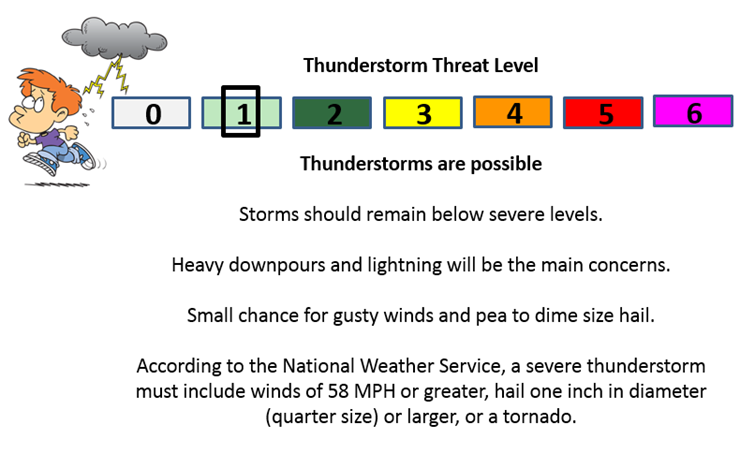
Can we expect severe thunderstorms over the next 24 hours? Remember that a severe thunderstorm is defined as a thunderstorm that produces 58 mph winds or higher, quarter size hail or larger, and/or a tornado.
Thunderstorm threat level is ONE. Some thunderstorms are possible on Monday night in the region. Most likely this would be western and northern counties. These storms should remain below severe levels.
Tuesday Severe Weather Outlook – Monitor updates for our far western/northwestern counties in Missouri. Some thunderstorms could reach severe levels. This is likely going to be closer to I44, but monitor updates.
Wednesday Severe Weather Outlook – Severe thunderstorms can’t be ruled out on Wednesday afternoon and night. The main concern would be strong winds and hail. Right now it appears southeast Missouri and the Missouri Bootheel would have the greatest risk of a few storms becoming severe. Monitor updates for the latest information.
Thursday Severe Weather Outlook – No severe weather
Friday Severe Weather Outlook – No severe weather
Saturday Severe Weather Outlook – No severe weather
Sunday Severe Weather Outlook – No severe weather

Will I need to take action?
Monitor updates on Wednesday afternoon and evening’s weather conditions. Thunderstorms possible.

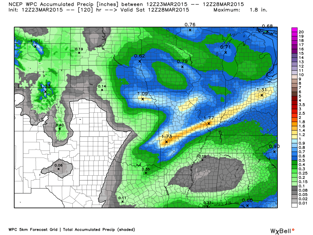
How much precipitation should we expect over the next few days?
We will have some light showers on/off over the coming days. Heavier rains will arrive on Wednesday afternoon and Wednesday night along a strong cold front. Thunderstorms will be possible.
Before that time, perhaps some showers and thunderstorms along a weaker front on Tuesday night, as well.
Image is from weatherbell.com

No snow or ice through Thursday. If you are traveling to northern Illinois and Indiana then monitor road conditions. Snow and sleet are likely over the next 24 hours in those areas.

This section of the blog is speculative forecast information. Because it is past the range of what meteorologists can forecast accurately, it should be considered speculation. Anything past day 5 is considered a long range forecast.
Colder weather for Friday into the weekend. Some data indicates 20’s possible in the region. But, the data has been running too cold lately. So, we will have to see just how cold it ends up being. Well below normal temperatures Friday into Sunday.

We have regional radars and local city radars – if a radar does not seem to be updating then try another one. Occasional browsers need their cache cleared. You may also try restarting your browser. That usually fixes the problem. Occasionally we do have a radar go down. That is why I have duplicates. Thus, if one fails then try another one.
If you have any problems then please send me an email beaudodson@usawx.com
WEATHER RADAR PAGE – Click here —
We also have a new national interactive radar – you can view that radar by clicking here.
Local interactive city radars include St Louis, Mt Vernon, Evansville, Poplar Bluff, Cape Girardeau, Marion, Paducah, Hopkinsville, Memphis, Nashville, Dyersburg, and all of eastern Kentucky – these are interactive radars. Local city radars – click here
NOTE: Occasionally you will see ground clutter on the radar (these are false echoes). Normally they show up close to the radar sites – including Paducah.

Regional Radar – Click on radar to take you our full radar page.


Regional Radar

Live Lightning Data – zoom and pan: Click here
Live Lightning Data with sound (click the sound button on the left side of the page): Click here

For the most up to date maps – click here
Day 1 Severe Weather Outlook from the Storm Prediction Center – Storm Prediction Center
What does thunderstorms, marginal, slight, enhanced, medium, and high risk mean? Click here

Current Severe thunderstorm and tornado watches from the Storm Prediction Center. The Storm Prediction Center is in charge of issuing watches. Our local National Weather Service Office in Paducah, Kentucky is in charge of issuing warnings.
Remember that a watch means that conditions are favorable for severe weather. Severe weather MIGHT develop over the coming hours. Watches normally last 4 to 8 hours. Monitor updates for possible warnings. A watch is a step below a warning.
A warning means to take immediate action to protect you and your family. Warnings usually last from 15 to 45 minutes. A warning means that a storm is moving into your area.
For additional watch information click here

![]()
Current WARNINGS (a warning means take action now). Click on your county to drill down to the latest warning information. Keep in mind that there can be a 2-3 minute delay in the updated warning information.
I strongly encourage you to use a NOAA Weather Radio or warning cell phone app for the most up to date warning information. Nothing is faster than a NOAA weather radio.


Color shaded counties are under some type of watch, warning, advisory, or special weather statement. Click your county to view the latest information.

Please visit your local National Weather Service Office by clicking here. The National Weather Service Office, for our region, is located in Paducah, Kentucky. They have a lot of maps and information on their site. Local people…local forecasters who care about our region.


Here is the official 6-10 day and 8-14 day temperature and precipitation outlook. Check the date stamp at the top of each image (so you understand the time frame).
The forecast maps below are issued by the Weather Prediction Center (NOAA).


The latest 8-14 day temperature and precipitation outlook. Note the dates are at the top of the image. These maps DO NOT tell you how high or low temperatures or precipitation will be. They simply give you the probability as to whether temperatures or precipitation will be above or below normal.


Who do you trust for your weather information and who holds them accountable?
I have studied weather in our region since the late 1970’s. I have 37 years of experience in observing our regions weather patterns. My degree is in Broadcast Meteorology from Mississippi State University and an Associate of Science (AS). I am currently working on my Bachelor’s Degree in Geoscience. Just need to finish two Spanish classes!
I am a member of the American Meteorological Society. I am a NOAA Weather-Ready Nation Ambassador. And, I am the Meteorologist for McCracken County Emergency Management.
I own and operate the Southern Illinois Weather Observatory.
There is a lot of noise on the internet. A lot of weather maps are posted without explanation. Over time you should learn who to trust for your weather information.
My forecast philosophy is simple and straight forward.
- Communicate in simple terms
- To be as accurate as possible within a reasonable time frame before an event
- Interact with you on Twitter, Facebook, and the blog
- Minimize the “hype” that you might see on television or through other weather sources
- Push you towards utilizing wall-to-wall LOCAL TV coverage during severe weather events
I am a recipient of the Mark Trail Award, WPSD Six Who Make A Difference Award, Kentucky Colonel, and the Caesar J. Fiamma” Award from the American Red Cross. In 2009 I was presented with the Kentucky Office of Highway Safety Award. I was recognized by the Kentucky House of Representatives for my service to the State of Kentucky leading up to several winter storms and severe weather outbreaks.
If you click on the image below you can read the Kentucky House of Representatives Resolution.

I am also President of the Shadow Angel Foundation which serves portions of western Kentucky and southern Illinois.
Many of my graphics are from www.weatherbell.com – a great resource for weather data, model data, and more


This blog was inspired by ABC 33/40’s Alabama Weather Blog – view their blog
Current tower cam view from the Weather Observatory- Click here for all cameras.

Southern Illinois Weather Observatory

The Weather Observatory

Southern Illinois Weather Observatory
WSIL TV 3 has a number of tower cameras. Click here for their tower camera page & Illinois Road Conditions

Marion, Illinois
WPSD TV 6 has a number of tower cameras. Click here for their tower camera page & Kentucky Road Conditions & Kentucky Highway and Interstate Cameras

Downtown Paducah, Kentucky
Benton, Kentucky Tower Camera – Click here for full view

Benton, Kentucky

I24 Paducah, Kentucky

I24 Mile Point 9 – Paducah, KY

I24 – Mile Point 3 Paducah, Kentucky

You can sign up for my AWARE email by clicking here I typically send out AWARE emails before severe weather, winter storms, or other active weather situations. I do not email watches or warnings. The emails are a basic “heads up” concerning incoming weather conditions.