We have some great sponsors for the Weather Talk Blog. Please support them when you have the opportunity.
Milner and Orr Funeral Home and Cremation Services located in Paducah, Kentucky and three other western Kentucky towns – at Milner and Orr they believe in families helping families. You can find Milner and Orr on Facebook, as well.
![]()

This forecast update covers far southern Illinois, far southeast Missouri, and far western Kentucky. See the coverage map on the right side of the blog.
Remember that weather evolves. Check back frequently for updates, especially during active weather.
The forecast numbers below may vary quite a bit across the region. These are averages.
Saturday – Spring like. A mix of sun and clouds. Really hoping the sun wins out on Saturday. Data does show some clouds in the region. Keep that in mind. Temperatures will rise well into the 60’s across the region. Winds from the west/southwest at 10-15 mph becoming northerly behind the cold front at 10-15 mph. My confidence in this part of the forecast verifying is high
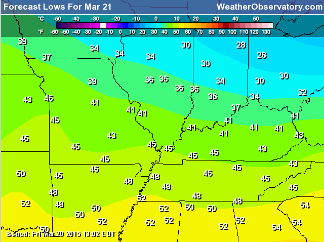
Saturday night – An increase in clouds. Cool temperatures. Lows in the 30’s far northeast counties and 40’s elsewhere. Winds from the east/northeast at 5-10 mph. My confidence in this part of the forecast verifying is high
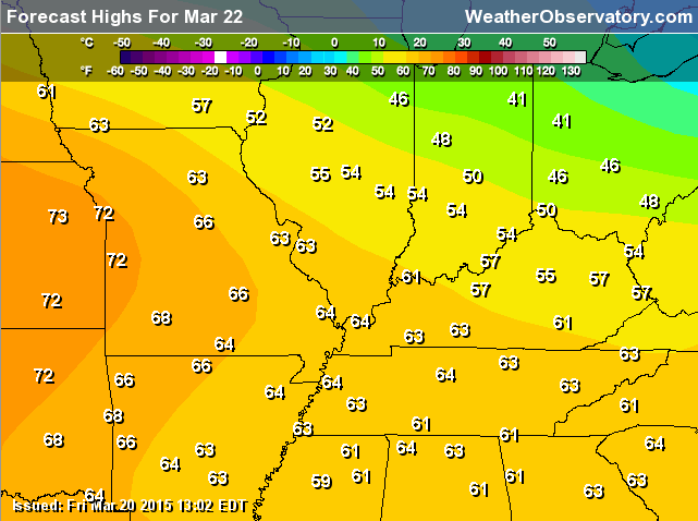
Sunday – Some clouds. Mild. Highs in the 50’s far northeast counties and 60’s elsewhere. Winds mostly out of the east/northeast and east at 10-15 mph. My confidence in this part of the forecast verifying is high
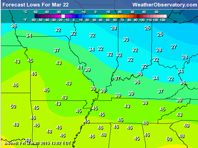
Sunday night – Clearing and cool. Low temperatures in the 30’s over northeast counties and 40’s elsewhere. Winds from the northeast at 10-15 mph. My confidence in this part of the forecast verifying is high
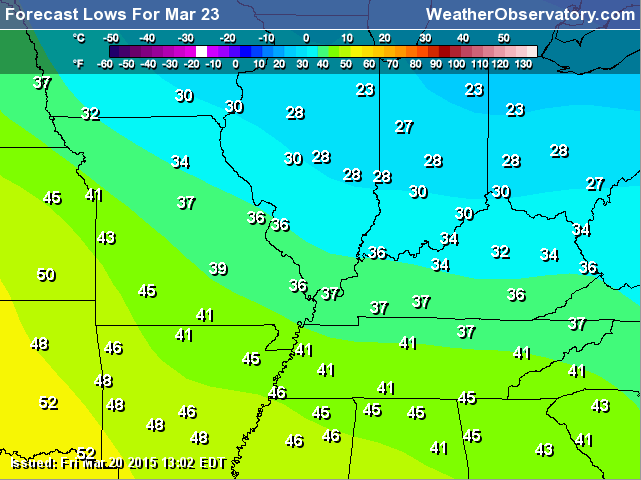
Monday – Partly sunny and cool. Highs in the 50’s northeast counties and upper 50’s to lower 60’s elsewhere. Winds variable but becoming southwest at 5-10 mph. My confidence in this part of the forecast verifying is high
Rain chances increase mid-week. See extended discussion. Perhaps some thunderstorms, as well.

Current Temperatures Around The Local Area


Don’t forget to check out the Southern Illinois Weather Observatory web-site for weather maps, tower cams, scanner feeds, radars, and much more! Click here

An explanation of what is happening in the atmosphere over the coming days…
Highlights
1. Saturday weather will be quite nice. Spring like.
2. Cold front moves through the area Saturday night. Slightly cooler on Sunday for parts of the area. Still nice.
3. Showers and thunderstorms, locally heavy rain, by the middle of the week. See the extended discussion for details.
4. Backed off the coldest temperatures for Sunday night into Tuesday. All signs point to cooler air, but not the colder air shown in the charts a few days ago. Instead of upper 20’s to lower 30’s it should be upper 30’s to around 40 on Monday morning.
5. Roller-coaster temperature ride over the coming weeks. Several chances for showers and storms. Active pattern with the potential for multiple rounds of rain/heavy rain over coming 2-3 weeks.
Saturday will remind everyone that spring has arrived. I guess that is fitting since it is the first full day of spring!
Friday was chilly over the region with temperatures more like February than March. Many areas remained in the 40’s for most of the day. Once the sun finally showed up then we popped up into the lower 50’s.
I checked the average highs for the first few weeks of February and they matched Friday’s temperatures. If you thought it was a bit chilly then you were correct.
A cold front will pass through the region Saturday afternoon and night. This front will bring slightly cooler weather for Sunday. The coolest temperatures will be over our northeast counties. Still, Sunday will be nice. Most areas should reach 60 degrees or above.
A bit cooler on Monday, as well. But, still not too bad. I had to back off the colder temperatures for Sunday night into Monday night. I am sure you won’t complain about that.
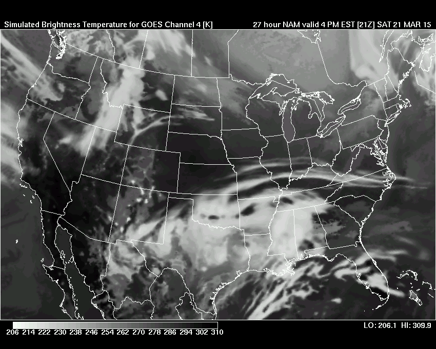
Let’s take a look at the future-cast satellite view for Saturday. Some clouds in the area. I am hoping the clouds won’t be much of an issue. Future-cast satellite images are from wright-weather.com
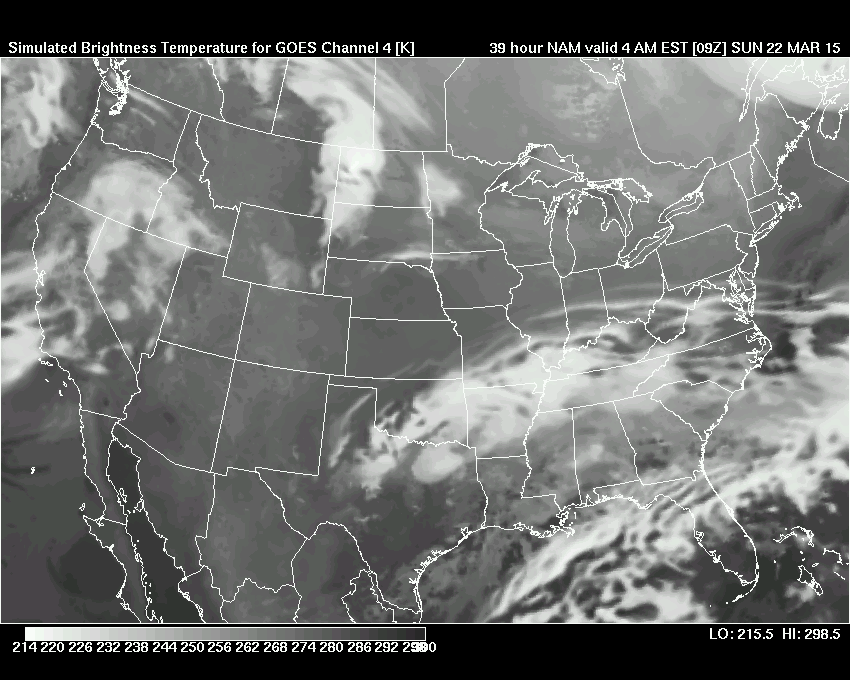
Sunday. This is the Sunday morning future-cast satellite view (below). You can see quite a few clouds in the region.
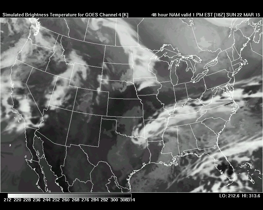
Sunday afternoon future-cast satellite view. Still quite a few clouds in the region. If we end up mostly cloudy on Sunday then that could stunt the temperature rise. Something to keep in mind.
An active weather pattern develops on Tuesday through at least Thursday. Rain and thunderstorms enter the picture. See the extended discussion for details.
Let’s take a look at some maps.
First, you might notice the area that I cover has expanded a bit. The map on the right side of the page. I had been touching on the counties I added, but figured I would go ahead and add them to the map. The counties in orange are the ones I usually forecast for or discuss in my analysis.
Saturday morning lows
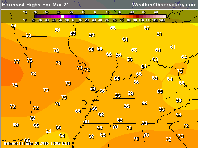
Saturday’s high temperature map – looking great!

Sunday morning low temperatures
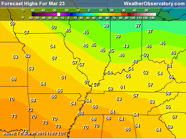
Sunday’s high temperature map
Monday morning low temperatures
Monday’s high temperature map (notice the cooler air trying to make some headway back into the area). The cooler air is centered more over our northeastern counties vs southwest.
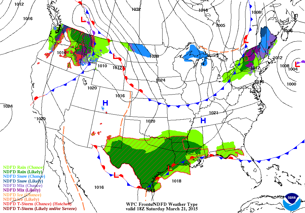
On the weather map below, you can see the cold front that will push through our region on Saturday afternoon into Sunday morning. It will make its way from north to south. This is the 12 noon weather map for Saturday. Cold front near St Louis. Front will be accompanied by some clouds. But, temperatures are not going to be impacted on Saturday by this front. We should all experience above normal temperatures. Normal highs for this time of the year are around 60-62 degrees.
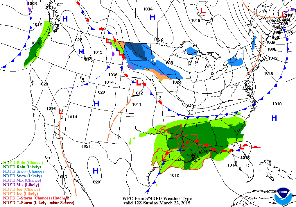
By Sunday at 7 am the front has moved through the area. You might notice a difference in temperatures on Sunday vs Saturday. But, not much. I suspect our northeast counties might remain mostly in the upper 50’s. That would be closer to the IL/IN border. Otherwise, most of us should see temperatures rise into the 60’s again on Sunday.
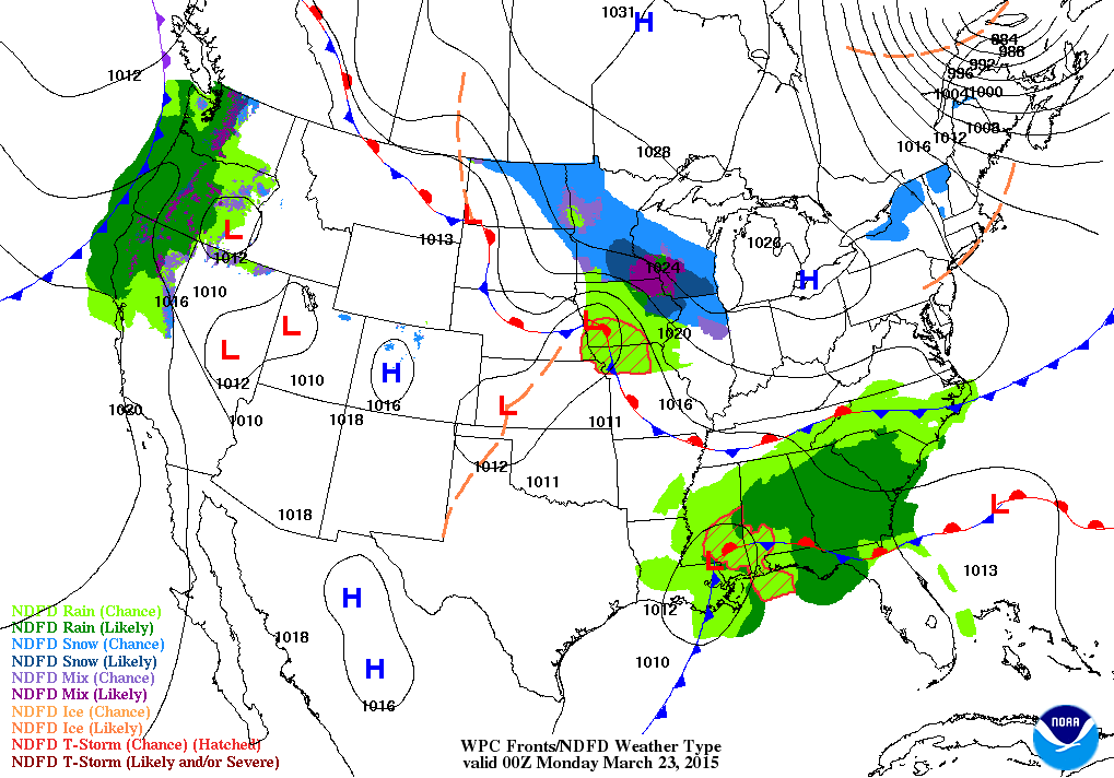
At one time it appeared we might have some light rain or light rain/snow mix on Monday. That system is going to be too far north to bring precipitation in our area. You can see it, on the weather map below, in Iowa and Wisconsin. Heavy snow across part of those states. Chicago may see some snow on Sunday night and Monday. Ack!
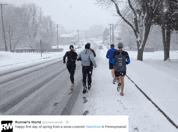
Speaking of snow. Did you see the pictures from Washington D.C. and the northeast? Snow fell on Friday. These photos are from Twitter. The first one is from Pennsylvania. Wet snow! No doubt everyone was just thrilled to see snowflakes for the opening of spring.
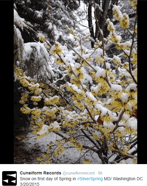
This second photograph (below) was taken in Silver Springs, Maryland. Thankfully spring snow normally does not last very long.
That was part of the system that brought sleet to our region on Wednesday.
Don’t forget to support our sponsors! You can view their ad’s below and on the right side bar of the page.

Updated temperatures and wind speed/direction for Sunday and Monday. Cloud cover is one concern I have for Saturday and Sunday. Hoping that Saturday ends up mostly sunny with just a few clouds.

No real concerns in the short term forecast. Thunderstorms may appear in the forecast Tuesday-Thursday. Some uncertainty on the exact timing of precipitation. Monitor updates. Severe weather threat is not zero, but it does appear to be small. Perhaps higher chances for severe weather to our west.
Check out our sponsors! There are more on the right side bar of the page, as well. Be sure and let them know that you appreciate their sponsorship of the WeatherTalk daily weather bulletin.
How about a $5 meal deal? The DQ Grill and Chill (located across from Noble Park in Paducah, Kentucky) is the newest WeatherTalk Blog sponsor! A local business helping to sponsor the weather information that you have come to love so much.
Check out their Facebook page for specials, as well DQ Grill and Chill on Facebook


Premier Portable Buildings proudly serving our region. For more information click the above ad or here
They can also be found on this Facebook page
G&C Multi-Services out of Paducah, Kentucky. G & C Multi-Services is a service provider in Western Kentucky that provides industrial and commercial equipment fabrication, machine troubleshooting, repair and maintenance, and installation. They can custom fabricate steel, stainless, and aluminum products per customer specifications.
Visit their web-site here. Or click the ad below! Facebook page.


Wortham Dental Care located in Paducah, Kentucky. The gentle dentist. Mercury free dentistry. They also do safe Mercury removal. You can find Wortham Dental Care on Facebook, as well

Trover’s Equipment and Lawn Care – Family owned and operated! They are a dealer for Snapper, Simplicity, Snapper Pro, Bad Boy Mowers, and Intimidator Utility Vehicles. They are a Stihl and Dolmar power products dealer. They also are a dealer for Briggs & Stratton, Kohler gas & diesel engines, and Kawasaki engines. They service and repair just about any brand. You can find them on Facebook, as well
The School Bus Stop Forecast is brought to your by Shawnee Professional Services. For more information click here

Shawnee Professional Services & Civil Design Group have been providing Land Surveying, Engineering, Grant Administration and Acquisition services for the past 20 years. Currently Licensed in Illinois, Kentucky, Missouri, Indiana, and Tennessee; please contact Shawnee for any Land Surveying or Engineering needs. Shawnee’s company size allows them to devote individual attention to each client and to approach each project with the required thoroughness to successfully complete the project, large or small. Visit Shawnee’s website at shawneepsi.com for more information. Shawnee has offices in Paducah, KY, Vienna, IL and Benton, IL.

Here are the current river stage forecasts. You can click your state and then the dot for your location. It will bring up the full forecast and hydrograph.
Click Here For River Stage Forecasts…
Here are some current forecast hydrographs. These will be updated each day with new information.


Smithland Lock and Dam

Paducah, Kentucky Forecast Stage

Cairo, Illinois

The wild card tells you where the uncertainties are in the forecast
Wild card in this forecast – The wild card in this forecast will be cloud cover on Saturday. Some clouds from time to time are possible.

Can we expect severe thunderstorms over the next 24 to 48 hours? Remember that a severe thunderstorm is defined as a thunderstorm that produces 58 mph winds or higher, quarter size hail or larger, and/or a tornado.
Thunderstorm threat level is ZERO for today and tomorrow.
Monday Severe Weather Outlook – No severe weather concerns
Tuesday Severe Weather Outlook – Monitor updates – thunderstorm chances could be on the rise.
Wednesday Severe Weather Outlook – Monitor updates
Thursday Severe Weather Outlook – Monitor updates


How much precipitation should we expect over the next few days?
We have quite a bit of rain expected as we push into the middle part of the new work week. The first round of precipitation on Tuesday could be our northern and northwestern counties. Then widespread rain on Wednesday/Wednesday night along a cold front. Some data continues rain into Thursday and Friday. Not ready to bank on that, just yet. But, keep it in mind.
Currently this is how things should unfold on the precipitation chances and totals.
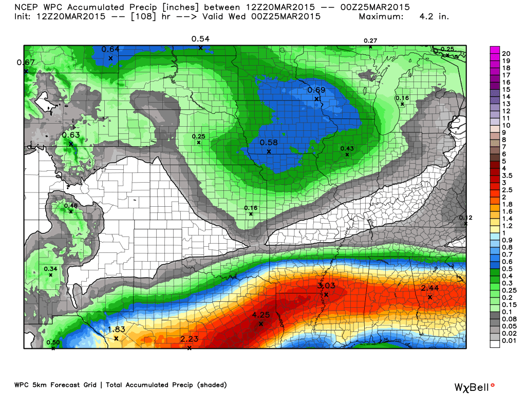
Precipitation will move into parts of Missouri and Illinois on Tuesday. Showers and some thunderstorms. Right now it appears our northwest and northern counties would have at least chances for rain. This map is the rainfall through Tuesday evening. See how the shaded area is more to the north? This is going to depend on the exact track of a disturbances/vort max that moves into the region. But, right now it appears northern areas for any precipitation on Tuesday. Map is from weatherbell.com
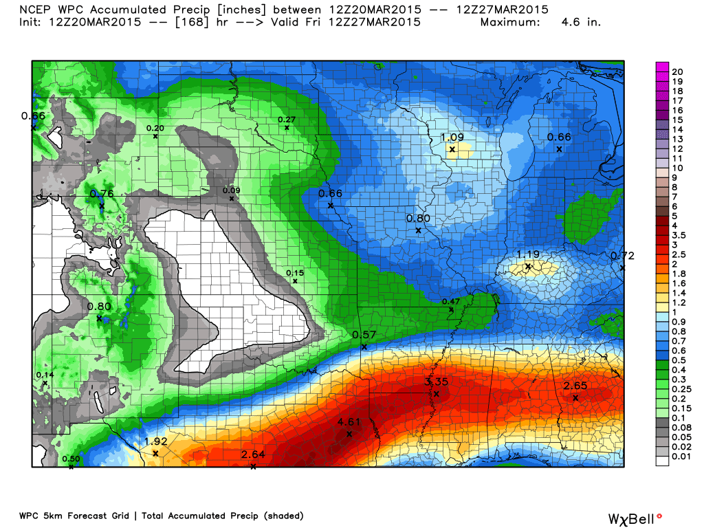
Now, let’s move ahead to the rest of the system. You can see the rain on Tuesday night into Thursday should add up to around 0.50″-1.00″ across the region. There are questions on those amounts. The reason there are question is because some of the models continue to spread rain into the region on Thursday into Friday morning. Primarily this is the GFS model that indicates addition disturbances moving along the frontal system.
I think the rain totals will need some adjusting as we move forward. But, for now…this gives you a general idea of what to expect.

No winter weather through Thursday. We are not finished with cold weather. I keep repeating that. I think we will deal with some decent cold shots into April. Several well below normal temperature days are likely to occur. Overall we may actually see more below normal temperatures days than above normal over the next couple of weeks.

This section of the blog is speculative forecast information. Because it is past the range of what meteorologists can forecast accurately, it should be considered speculation. Anything past day 5 is considered a long range forecast.
Highlights…
1. Active weather likely over the next 2-3 weeks.
2. Several storm systems will bring precipitation chances to the region.
3. We aren’t finished with the cold shots of air. Some much below normal temperatures are likely over the next 2 weeks. There will be warm periods of time, as well. Spring! Roller-coaster ride of weather.
Rain chances next week…
Best rain chances in our region will probably be on Wednesday and Wednesday night. A strong cold front will approach our region on Wednesday. Ahead of the front we will experience a surge of warm/moist air from the Gulf of Mexico. Dew points will be on the rise. Wind fields aloft will increase in strength. We should see some instability (CAPE). That all equals a chance for thunderstorms.
The threat for severe thunderstorms is not zero. But, the threat does not appear to be great.
The Storm Prediction Center will likely outline parts of the Missouri Valley in a risk for a few severe storms with this cold front. Monitor updates as we move forward. The greatest chances for severe weather may remain just to our west. But, again – monitor updates.
Let me step you through some of the weather maps for this next rain event
This is the GFS model
This first map is for Tuesday afternoon. You can see showers and thunderstorms over parts of Missouri and Illinois (the green colored area). Mostly northern parts of our area. Perhaps even north of our area all together.
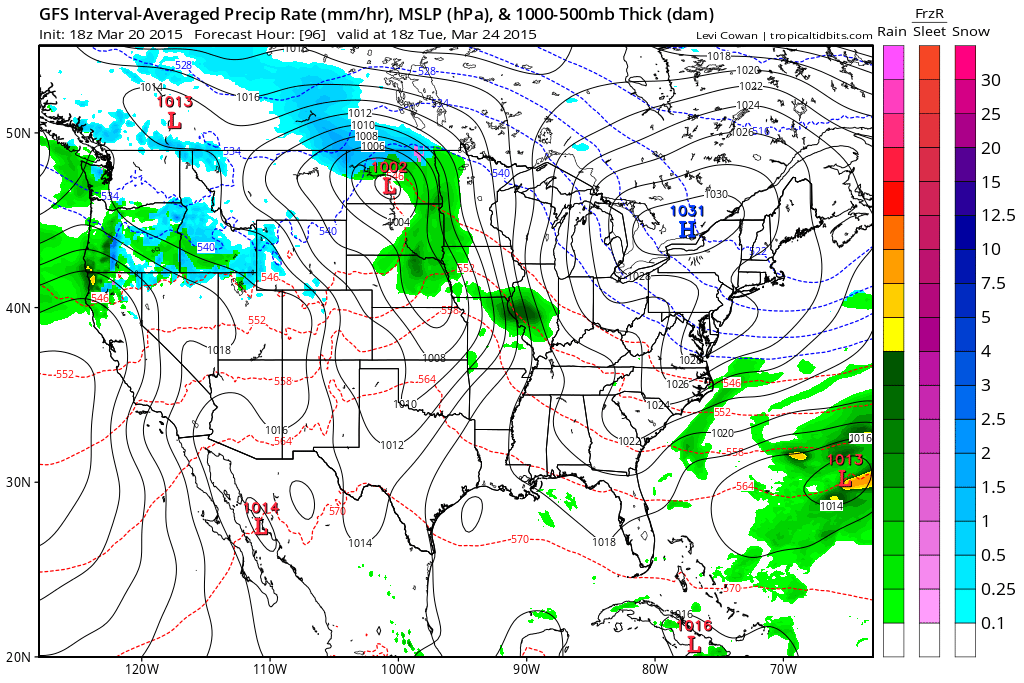
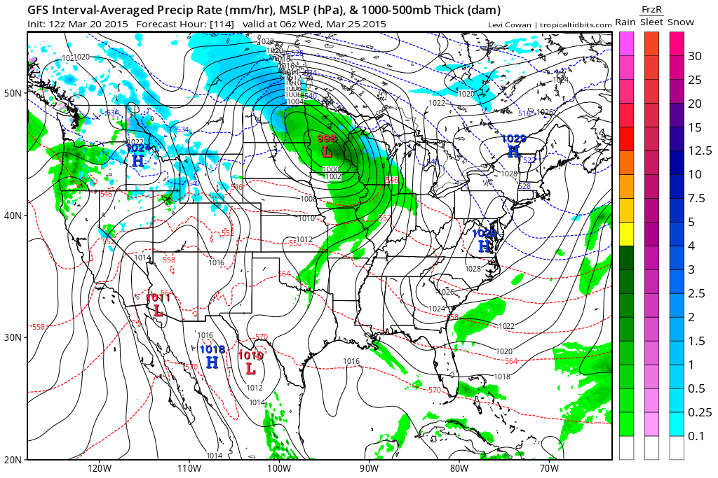
Then on Tuesday night into Wednesday morning. Showers and storms still mostly to our north and west. You can see the area of low pressure over Minnesota. Wound up nicely. That likely means gusty winds for our region on Tuesday into Thursday.
We pull ahead to Wednesday. This is when shower and thunderstorm chances should increase in our region. This will be along a strong cold front. The green and yellow area represents showers and thunderstorms.
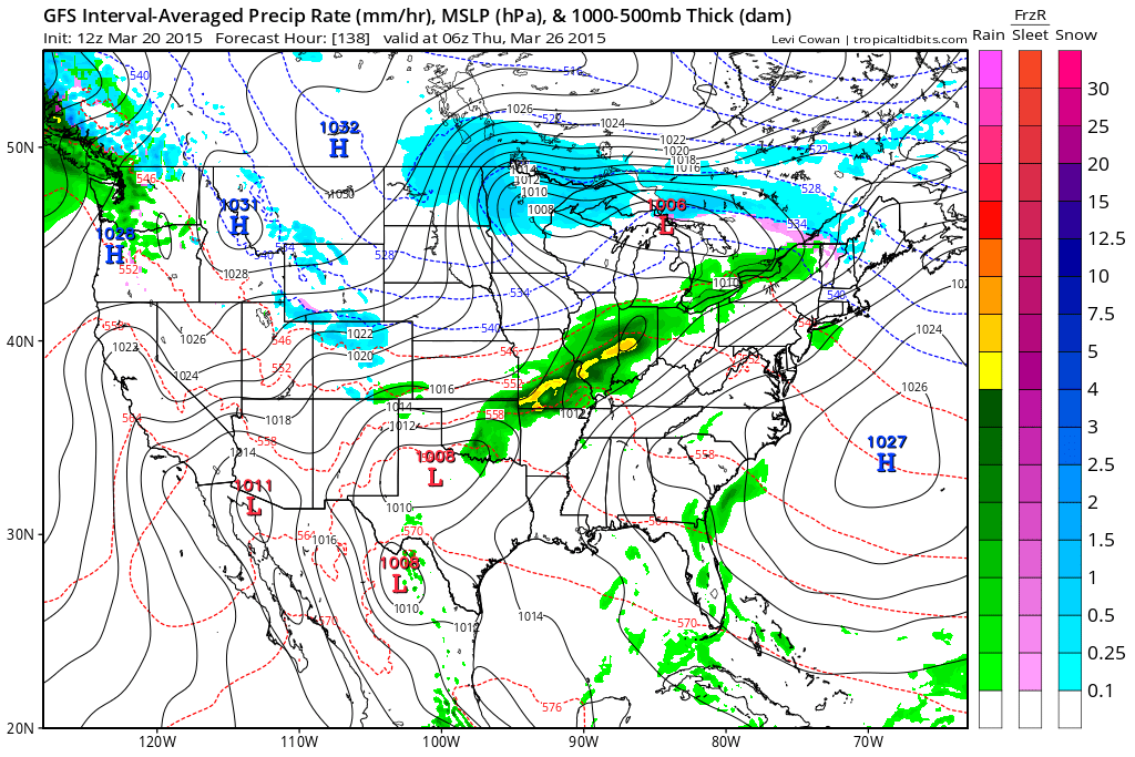
The GFS develops another area of low pressure along the front on Thursday. This enhances rainfall totals and keeps it going a bit longer. Not all the data agrees with this. I will monitor and update as we move forward.
This is the Thursday morning weather map according to the GFS model. You can see rain in our region. The green area is rain. The yellow area would be heavier rain showers/thunderstorms.
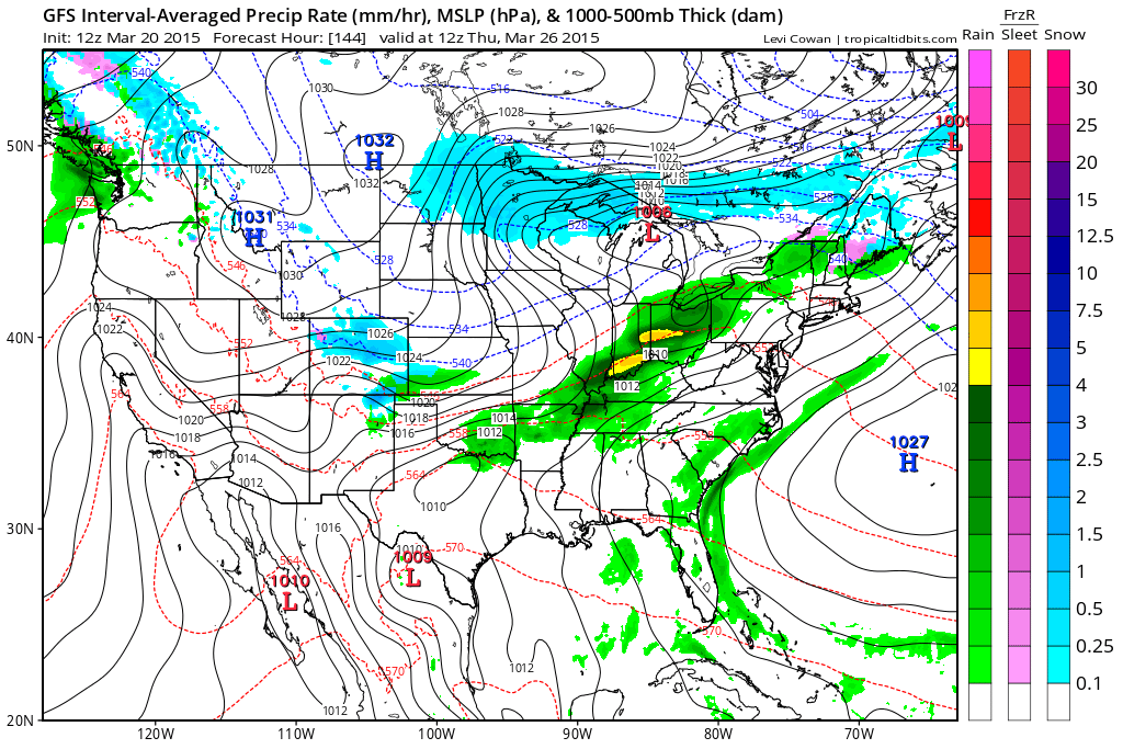
Beyond Thursday the models show additional chances for precipitation. Colder air, as well.
We are going to have to start talking about severe weather risks over the coming weeks. I recommend you have a nice weather radio. The Midland 300 model is my choice. There are several models by Midland.

Here is the official 6-10 day and 8-14 day temperature and precipitation outlook. Check the date stamp at the top of each image (so you understand the time frame).
The forecast maps below are issued by the Weather Prediction Center (NOAA).


The latest 8-14 day temperature and precipitation outlook. Note the dates are at the top of the image. These maps DO NOT tell you how high or low temperatures or precipitation will be. They simply give you the probability as to whether temperatures or precipitation will be above or below normal.


Who do you trust for your weather information and who holds them accountable?
I have studied weather in our region since the late 1970’s. I have 37 years of experience in observing our regions weather patterns. My degree is in Broadcast Meteorology from Mississippi State University and an Associate of Science (AS). I am currently working on my Bachelor’s Degree in Geoscience. Just need to finish two Spanish classes!
I am a member of the American Meteorological Society. I am a NOAA Weather-Ready Nation Ambassador. And, I am the Meteorologist for McCracken County Emergency Management.
I own and operate the Southern Illinois Weather Observatory.
There is a lot of noise on the internet. A lot of weather maps are posted without explanation. Over time you should learn who to trust for your weather information.
My forecast philosophy is simple and straight forward.
- Communicate in simple terms
- To be as accurate as possible within a reasonable time frame before an event
- Interact with you on Twitter, Facebook, and the blog
- Minimize the “hype” that you might see on television or through other weather sources
- Push you towards utilizing wall-to-wall LOCAL TV coverage during severe weather events
I am a recipient of the Mark Trail Award, WPSD Six Who Make A Difference Award, Kentucky Colonel, and the Caesar J. Fiamma” Award from the American Red Cross. In 2009 I was presented with the Kentucky Office of Highway Safety Award. I was recognized by the Kentucky House of Representatives for my service to the State of Kentucky leading up to several winter storms and severe weather outbreaks.
If you click on the image below you can read the Kentucky House of Representatives Resolution.

I am also President of the Shadow Angel Foundation which serves portions of western Kentucky and southern Illinois.
Many of my graphics are from www.weatherbell.com – a great resource for weather data, model data, and more


This blog was inspired by ABC 33/40’s Alabama Weather Blog – view their blog
Current tower cam view from the Weather Observatory- Click here for all cameras.

Southern Illinois Weather Observatory

The Weather Observatory

Southern Illinois Weather Observatory
WSIL TV 3 has a number of tower cameras. Click here for their tower camera page & Illinois Road Conditions

Marion, Illinois
WPSD TV 6 has a number of tower cameras. Click here for their tower camera page & Kentucky Road Conditions & Kentucky Highway and Interstate Cameras

Downtown Paducah, Kentucky
Benton, Kentucky Tower Camera – Click here for full view

Benton, Kentucky

I24 Paducah, Kentucky

I24 Mile Point 9 – Paducah, KY

I24 – Mile Point 3 Paducah, Kentucky

You can sign up for my AWARE email by clicking here I typically send out AWARE emails before severe weather, winter storms, or other active weather situations. I do not email watches or warnings. The emails are a basic “heads up” concerning incoming weather conditions.