We have some great sponsors for the Weather Talk Blog. Please support them when you have the opportunity.
Milner and Orr Funeral Home and Cremation Services located in Paducah, Kentucky and three other western Kentucky towns – at Milner and Orr they believe in families helping families. You can find Milner and Orr on Facebook, as well.
![]()

This forecast update covers far southern Illinois, far southeast Missouri, and far western Kentucky. See the coverage map on the right side of the blog.
Remember that weather evolves. Check back frequently for updates, especially during active weather.
The forecast numbers below may vary quite a bit across the region. These are averages.
Thursday – Cloudy with some light rain showers remaining in the area. Below normal temperatures. Highs only in the upper 40’s to lower 50’s. East winds at 5-10 mph. My confidence in this part of the forecast verifying is high
WEATHER RADAR PAGE – Click here —
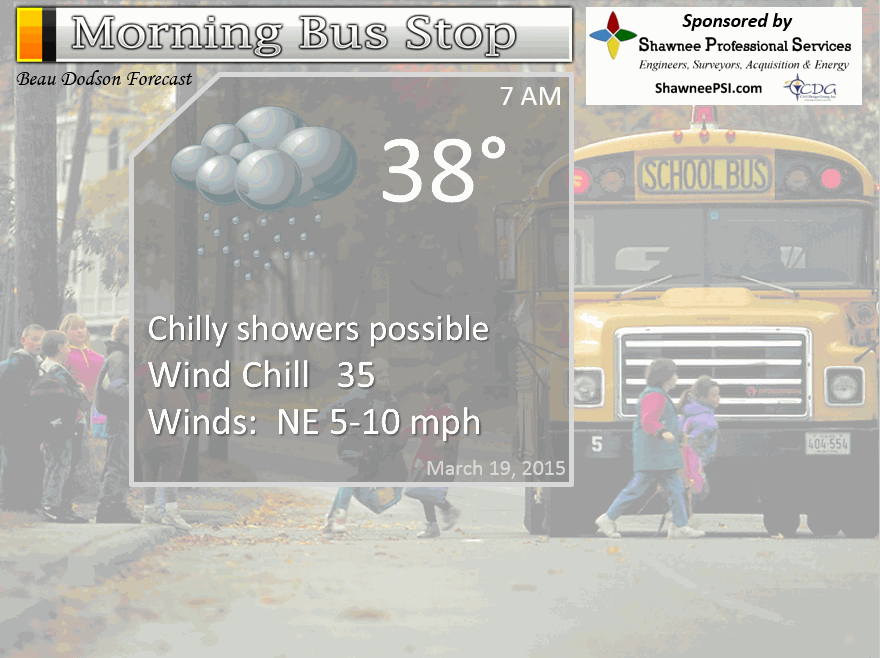
Morning School Bus Stop Weather – Chance for chilly rain showers. Cold morning with temperatures in the upper 30’s to lower 40’s. Light winds. Chances of schools being delayed because of the weather
—————————————————————————————-
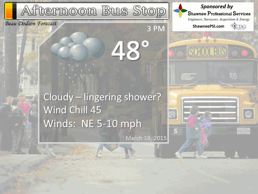
Afternoon School Bus Stop Weather – Cloudy with a light shower possible. Temperatures mainly in the 40’s. Light winds.
Thursday night – Cloudy. Perhaps a light rain shower. Otherwise, cool with clouds. Light winds. Lows in the 40’s. Light winds – Westerly at 5 mph. My confidence in this part of the forecast verifying is high
Friday – Mostly cloudy. Small chance for a shower. Cool. Highs in the 50’s. Northwest winds at 5-10 mph. My confidence in this part of the forecast verifying is low
Friday night – Clearing and cool. Lows in the 40’s. West winds at 5-10 mph. My confidence in this part of the forecast verifying is medium
Saturday – Partly sunny and mild. Highs into the 60’s! Pick day of the next 5 days. My confidence in this part of the forecast verifying is high
Sunday should be dry with highs in the 60’s.

The School Bus Stop Forecast is brought to your by Shawnee Professional Services. For more information click here
Current Temperatures Around The Local Area


An explanation of what is happening in the atmosphere over the coming days…
Highlights
1. Some light showers on Thursday/Chilly temperatures
2. Pick day of the upcoming 5 days will be Saturday (spring like again)
3. Cold front Sunday with cooling temperatures Sunday night into Monday night. Back into the 30’s for lows.
4. Small chance for precipitation on Monday/Monday night. If it occurs then prob light rain or light rain/snow mix. Does not look to be anything of significant and the system is very weak. That means it may not precipitate at all.
5. Long range discussion – thunderstorms possible late next week (heavy rain…perhaps)
Sleet fell over the area on Wednesday. This was because dew points were in the teens and lower twenties. Precipitation fell through this cold layer and was not able to melt. Surface temperatures were in the forties at the time of the sleet. A bit unusual, but not unheard of. The sleet only lasted a short period of time. Just a reminder that winter isn’t quite over.
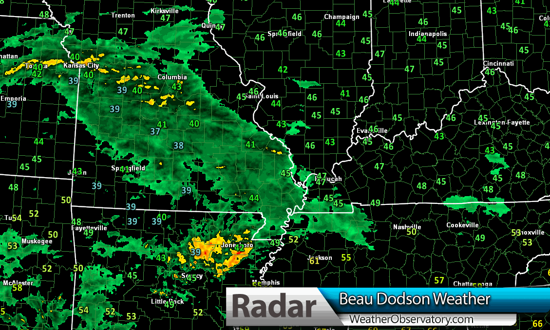
Our precipitation maker has been producing light rain over the region. It moved in from the west on Wednesday afternoon and evening.
Here was a radar shot from 2 pm on Wednesday. You can see the rain moving east.
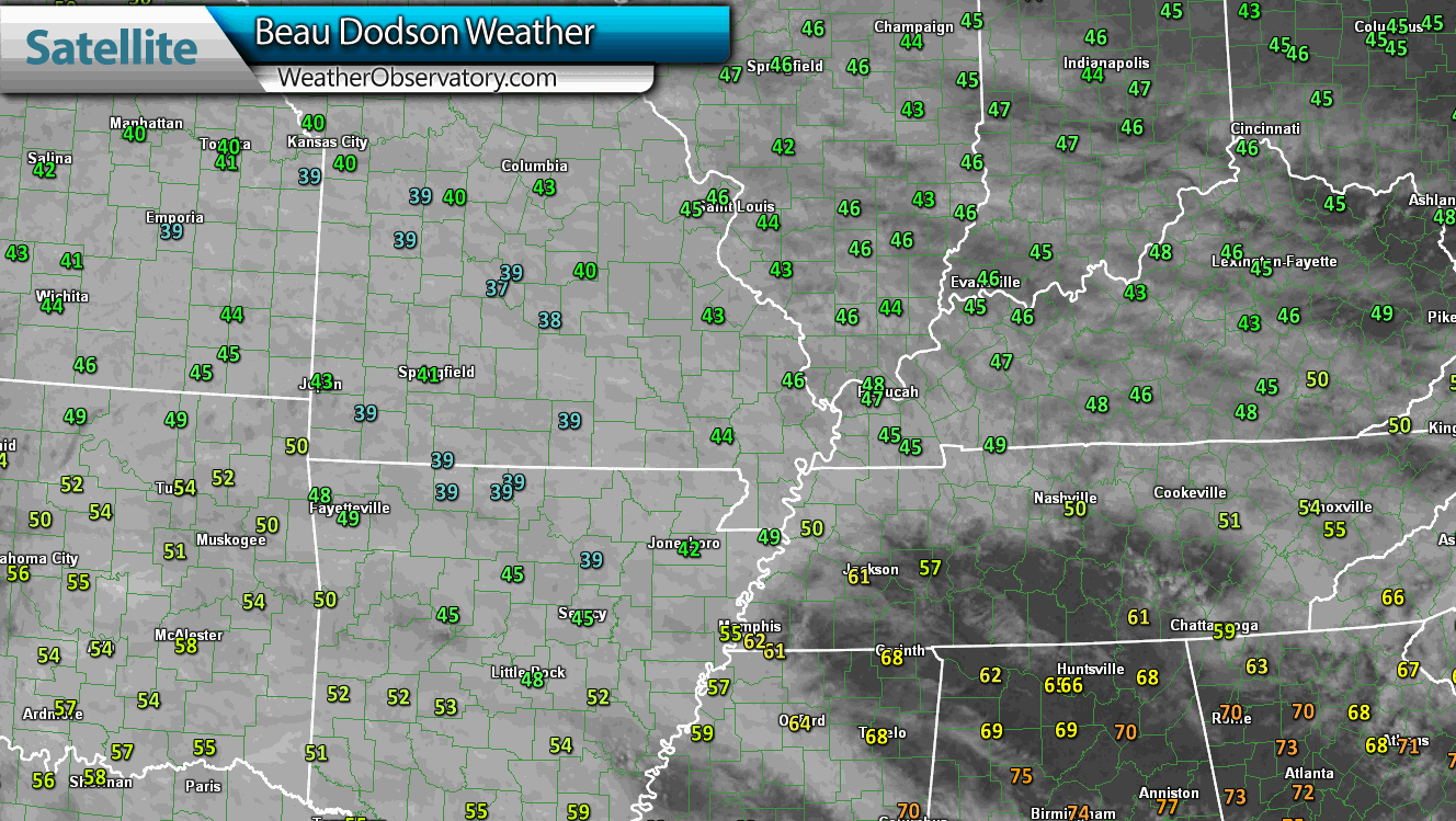
Satellite view on Wednesday afternoon of the messy system. Check out those temperatures! At 2 pm on March 18th. Temperatures were in the 30’s over Missouri and parts of Arkansas. Click images for larger views.
Rainfall totals, once all is said and done, should be on the light side. I am forecasting totals of 0.10″-0.30″. Been bouncing back and forth between going a little bit less than 0.30″ and keeping it at that. Either way, not a huge rain maker. Thank goodness. We do not need any additional heavy rain for the river basins (speaking of rivers…check out the latest crest forecast in the river flood section further down in the blog).
Another weak system rolls along the front on Friday. I have been struggling with whether or not to put rain in the forecast Friday. I continue to struggle with that subject. Small rain chances. I will post an update on this later today.
Temperatures on Friday will be warmer. Highs into the 50’s again. Not bad not bad. BUT, Saturday is going to be stellar. I am forecasting highs into the 60’s. Spring like conditions!
Somewhat cooler air returns on Sunday and Monday. Although the new data indicates Sunday might rebound into the 60’s, as well. Temperatures on Monday may actually fall during the day. Sort of like what happened on Tuesday. Warmer for our southern counties and cooler over northern counties in Illinois.
Monday could bring 50’s to the southern half of the area and 40’s north. Keep that in mind. Then temperatures may fall through the day as colder air filters back in. Always a bit tricky forecasting falling temperatures during the day in March. The other day temperatures fell 10 degrees behind the cold front…but it stalled out along the Ohio River. Western Kentucky ended up in the 50’s and did not see much in the way of falling temperatures until the evening hours.
Expect a real roller-coaster of temperatures over the next 14 days. Spring? That is hot spring likes it. Back and forth in the temperature department. Always makes for fun forecasting.
I am watching a stronger storm system next week. Thunderstorms? Perhaps. See the extended discussion on that subject (further down in the blog update).
Don’t forget to support our sponsors!

Updated temperatures and rain chances for Friday. No major changes to the ongoing forecast.

No major concerns in the current forecast. No severe weather and no significant wintry weather.
Check out our sponsors! There are more on the right side bar of the page, as well. Be sure and let them know that you appreciate their sponsorship of the WeatherTalk daily weather bulletin.
How about a $5 meal deal? The DQ Grill and Chill (located across from Noble Park in Paducah, Kentucky) is the newest WeatherTalk Blog sponsor! A local business helping to sponsor the weather information that you have come to love so much.
Check out their Facebook page for specials, as well DQ Grill and Chill on Facebook


Premier Portable Buildings proudly serving our region. For more information click the above ad or here
They can also be found on this Facebook page
G&C Multi-Services out of Paducah, Kentucky. G & C Multi-Services is a service provider in Western Kentucky that provides industrial and commercial equipment fabrication, machine troubleshooting, repair and maintenance, and installation. They can custom fabricate steel, stainless, and aluminum products per customer specifications.
Visit their web-site here. Or click the ad below! Facebook page.


Wortham Dental Care located in Paducah, Kentucky. The gentle dentist. Mercury free dentistry. They also do safe Mercury removal. You can find Wortham Dental Care on Facebook, as well

Trover’s Equipment and Lawn Care – Family owned and operated! They are a dealer for Snapper, Simplicity, Snapper Pro, Bad Boy Mowers, and Intimidator Utility Vehicles. They are a Stihl and Dolmar power products dealer. They also are a dealer for Briggs & Stratton, Kohler gas & diesel engines, and Kawasaki engines. They service and repair just about any brand. You can find them on Facebook, as well
The School Bus Stop Forecast is brought to your by Shawnee Professional Services. For more information click here

Shawnee Professional Services & Civil Design Group have been providing Land Surveying, Engineering, Grant Administration and Acquisition services for the past 20 years. Currently Licensed in Illinois, Kentucky, Missouri, Indiana, and Tennessee; please contact Shawnee for any Land Surveying or Engineering needs. Shawnee’s company size allows them to devote individual attention to each client and to approach each project with the required thoroughness to successfully complete the project, large or small. Visit Shawnee’s website at shawneepsi.com for more information. Shawnee has offices in Paducah, KY, Vienna, IL and Benton, IL.
.

Here are the current river stage forecasts. You can click your state and then the dot for your location. It will bring up the full forecast and hydrograph.
Click Here For River Stage Forecasts…
Here are some current forecast hydrographs. These will be updated each day with new information.

Shawneetown, Illinois

Smithland Lock and Dam

Paducah, Kentucky Forecast Stage

Cairo, Illinois

The wild card tells you where the uncertainties are in the forecast
Wild card in this forecast – how much rain will fall on Thursday. Current rain forecast appears on track. Could there be some pockets of greater than 0.30″? That is the question mark. I think most of us end up with 0.15″-0.30″ in total. Some questions on Friday’s rain chances. Will continue to update as we move forward (I will update the top part of the page later today)

Can we expect severe thunderstorms over the next few days? Remember that a severe thunderstorm is defined as a thunderstorm that produces 58 mph winds or higher, quarter size hail or larger, and/or a tornado.
Thunderstorm threat level is ZERO
Thursday Severe Weather Outlook – No severe weather threats
Friday Severe Weather Outlook – No severe weather threats
Saturday Severe Weather Outlook – No severe weather threats
Sunday Severe Weather Outlook – No severe weather threats
Monday Severe Weather Outlook – No severe weather threats
Tuesday Severe Weather Outlook – No severe weather threats
Wednesday into Friday Severe Weather Outlook – monitoring


How much precipitation should we expect over the next few days?
Light totals. Expecting less than 1/2″ across the region and more likely in the 0.10-0.30″ range.

Snow is not in the forecast through Sunday.
Removed rain/snow mix on Monday as temperatures should be warmer than expected and the system is so weak that is my not even produce precipitation.

This section of the blog is speculative forecast information. Because it is past the range of what meteorologists can forecast accurately, it should be considered speculation. Anything past day 5 is considered a long range forecast.
Other than the cooler air returning (after a mild Saturday) the big story will be the roller-coaster ride of temperatures as we push into April. Cold shots continue to show up in the charts. Cold, warm, cold, warm, cold, warm. That will be the forecast for the coming weeks.
The good news is that we will have more and more milder air to work with. With each passing week our average temperatures goes up. That means that cold shots eventually become cool shots. I am sure everyone will welcome the day when I can stop putting 30’s in the forecast. We aren’t there yet.
Normal highs for this time of the year are around 60 degrees and normal lows are in the 40’s.
We may have to deal with some pockets of 20’s for lows early next week. We had some lower 30’s this morning over our far northern counties and northeast counties. We had some 20’s just north of there. Most of us remained above freezing.
I know some of you want to plant gardens. The charts still show chances for sub-freezing weather in the cards. Patience is a virtue, I suppose.
A stronger cold front is showing up in the long range charts. That front should arrive next Thursday/Friday. Timing will need to be fine tuned. Perhaps a band of showers and thunderstorms with the front. Not sure on the severe weather threat. I will be closely monitoring it.
We have not had any severe weather in our region since I believe last October. That is just amazing. But, that is also what cold air will do for you. We have had a lot of cold snaps over the winter months. That has saved us from the threat of severe thunderstorms and tornadoes. At some point the cold snaps will stop and of course we will deal with severe storms. Happens every year.
Just a reminder…once severe weather arrives I will be posting live severe weather threads on the Facebook page and I will post them on here, as well.
The Facebook page updates will allow you to ask questions. I usually break it down into 3 hour threads as an event unfolds.
Let’s take a look at a few GFS model charts. This is the chart for Monday. You can see the light snow (blue colors) over parts of Illinois and Missouri. Again, this is a weak system and likely won’t produce much in our region. I did mention it. But, again – not a big deal.
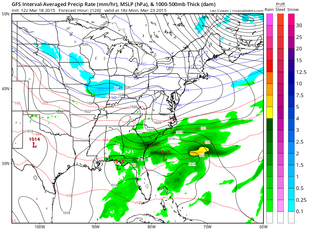
Moving ahead to the stronger system. These are the maps for Wednesday and Thursday. Quite a bit of rain along the front. Some thunderstorms possible.
The latest GFS model data shows the system coming in on Thursday and Friday vs Wednesday and Thursday.
Again, not sure on the timing, but I want you to have the general idea that we may have some showers and storms later next week.
Wednesday afternoon map – the area of low pressure is over NE Missouri into Iowa and Minnesota. Trying to get itself organized.
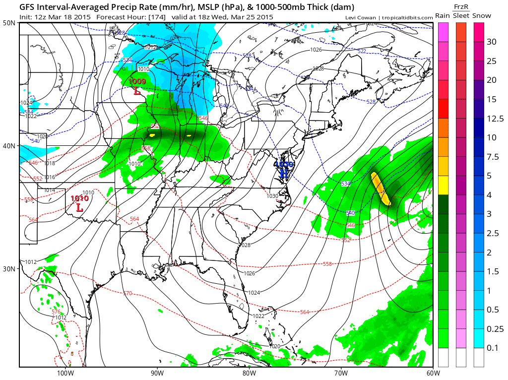
This is the Wednesday night map – rain moving into our area with some thunderstorms possible
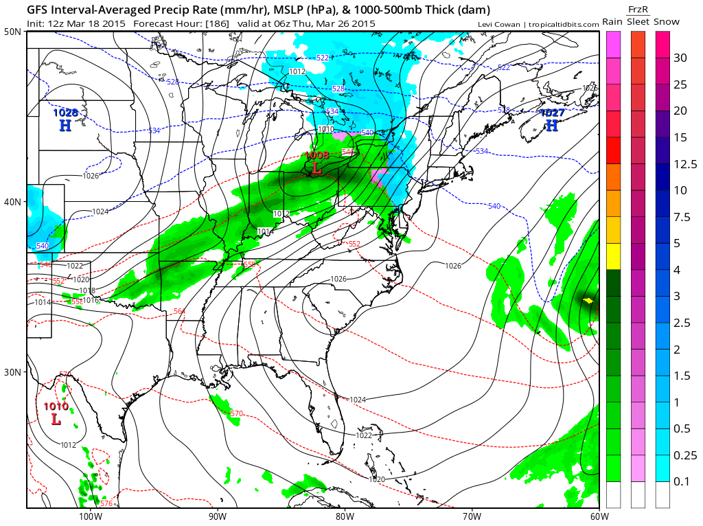
By Thursday morning we still have rain in the area. Front slows down as it crossed our counties. Thus, the rain lingers. We will see if that happens. Still one week away. Long time for models.
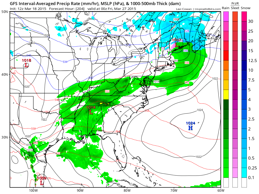
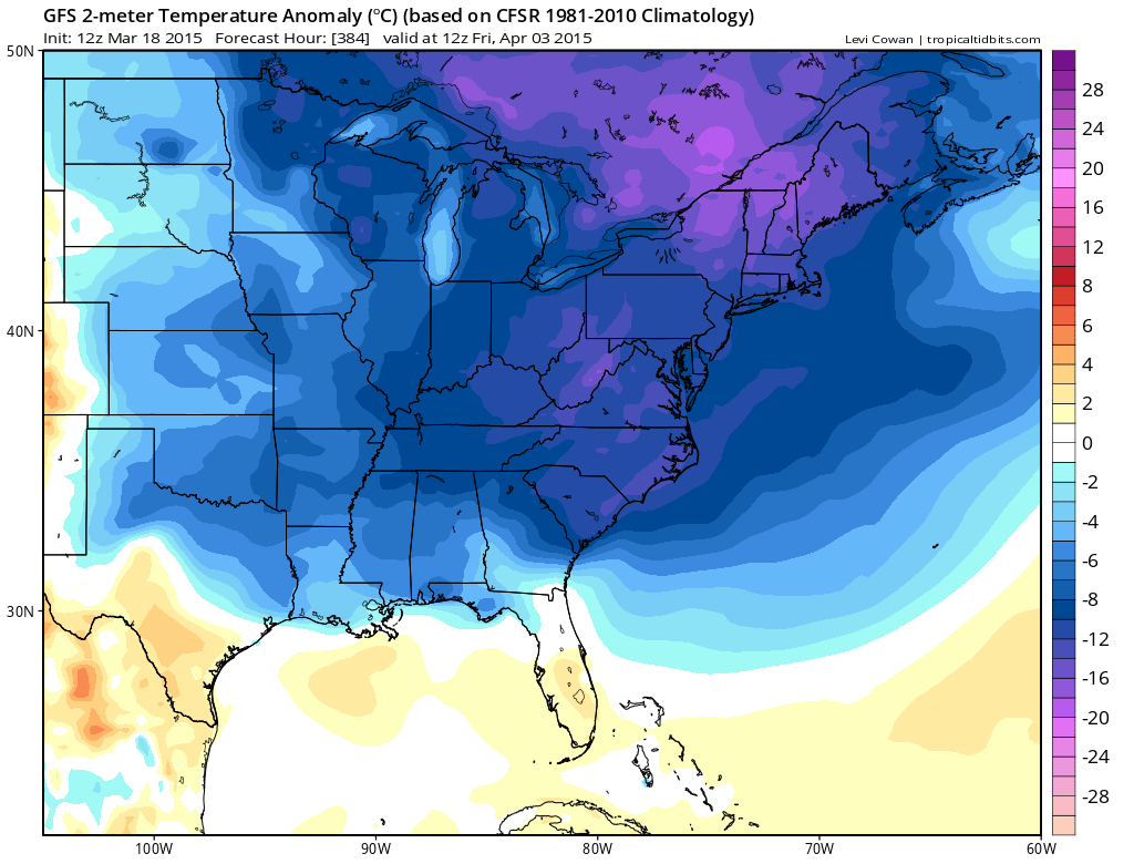
And for good measure. Here is the beginning of April. Temperatures anomaly forecast. Well below normal temperatures? Well, that is what the GFS is thinking. Long way off. But, the general idea that cold shots are going to continue for awhile is definitely still on the table. Roller-coaster for temperatures over the coming weeks.

We have regional radars and local city radars – if a radar does not seem to be updating then try another one. Occasional browsers need their cache cleared. You may also try restarting your browser. That usually fixes the problem. Occasionally we do have a radar go down. That is why I have duplicates. Thus, if one fails then try another one.
If you have any problems then please send me an email beaudodson@usawx.com
WEATHER RADAR PAGE – Click here —
We also have a new national interactive radar – you can view that radar by clicking here.
Local interactive city radars include St Louis, Mt Vernon, Evansville, Poplar Bluff, Cape Girardeau, Marion, Paducah, Hopkinsville, Memphis, Nashville, Dyersburg, and all of eastern Kentucky – these are interactive radars. Local city radars – click here
NOTE: Occasionally you will see ground clutter on the radar (these are false echoes). Normally they show up close to the radar sites – including Paducah.

Regional Radar – Click on radar to take you our full radar page.


Regional Radar
![]()
Current WARNINGS (a warning means take action now). Click on your county to drill down to the latest warning information. Keep in mind that there can be a 2-3 minute delay in the updated warning information.
I strongly encourage you to use a NOAA Weather Radio or warning cell phone app for the most up to date warning information. Nothing is faster than a NOAA weather radio.
Color shaded counties are under some type of watch, warning, advisory, or special weather statement. Click your county to view the latest information.


Please visit your local National Weather Service Office by clicking here. The National Weather Service Office, for our region, is located in Paducah, Kentucky. They have a lot of maps and information on their site. Local people…local forecasters who care about our region.


Here is the official 6-10 day and 8-14 day temperature and precipitation outlook. Check the date stamp at the top of each image (so you understand the time frame).
The forecast maps below are issued by the Weather Prediction Center (NOAA).


The latest 8-14 day temperature and precipitation outlook. Note the dates are at the top of the image. These maps DO NOT tell you how high or low temperatures or precipitation will be. They simply give you the probability as to whether temperatures or precipitation will be above or below normal.


Who do you trust for your weather information and who holds them accountable?
I have studied weather in our region since the late 1970’s. I have 37 years of experience in observing our regions weather patterns. My degree is in Broadcast Meteorology from Mississippi State University and an Associate of Science (AS). I am currently working on my Bachelor’s Degree in Geoscience. Just need to finish two Spanish classes!
I am a member of the American Meteorological Society. I am a NOAA Weather-Ready Nation Ambassador. And, I am the Meteorologist for McCracken County Emergency Management.
I own and operate the Southern Illinois Weather Observatory.
There is a lot of noise on the internet. A lot of weather maps are posted without explanation. Over time you should learn who to trust for your weather information.
My forecast philosophy is simple and straight forward.
- Communicate in simple terms
- To be as accurate as possible within a reasonable time frame before an event
- Interact with you on Twitter, Facebook, and the blog
- Minimize the “hype” that you might see on television or through other weather sources
- Push you towards utilizing wall-to-wall LOCAL TV coverage during severe weather events
I am a recipient of the Mark Trail Award, WPSD Six Who Make A Difference Award, Kentucky Colonel, and the Caesar J. Fiamma” Award from the American Red Cross. In 2009 I was presented with the Kentucky Office of Highway Safety Award. I was recognized by the Kentucky House of Representatives for my service to the State of Kentucky leading up to several winter storms and severe weather outbreaks.
If you click on the image below you can read the Kentucky House of Representatives Resolution.

I am also President of the Shadow Angel Foundation which serves portions of western Kentucky and southern Illinois.
Many of my graphics are from www.weatherbell.com – a great resource for weather data, model data, and more


This blog was inspired by ABC 33/40’s Alabama Weather Blog – view their blog
Current tower cam view from the Weather Observatory- Click here for all cameras.

Southern Illinois Weather Observatory

The Weather Observatory

Southern Illinois Weather Observatory
WSIL TV 3 has a number of tower cameras. Click here for their tower camera page & Illinois Road Conditions

Marion, Illinois
WPSD TV 6 has a number of tower cameras. Click here for their tower camera page & Kentucky Road Conditions & Kentucky Highway and Interstate Cameras

Downtown Paducah, Kentucky
Benton, Kentucky Tower Camera – Click here for full view

Benton, Kentucky

I24 Paducah, Kentucky

I24 Mile Point 9 – Paducah, KY

I24 – Mile Point 3 Paducah, Kentucky

You can sign up for my AWARE email by clicking here I typically send out AWARE emails before severe weather, winter storms, or other active weather situations. I do not email watches or warnings. The emails are a basic “heads up” concerning incoming weather conditions.