We have some great sponsors for the Weather Talk Blog. Please support them when you have the opportunity.
Milner and Orr Funeral Home and Cremation Services located in Paducah, Kentucky and three other western Kentucky towns – at Milner and Orr they believe in families helping families. You can find Milner and Orr on Facebook, as well.
![]()

This forecast update covers far southern Illinois, far southeast Missouri, and far western Kentucky. See the coverage map on the right side of the blog.
Remember that weather evolves. Check back frequently for updates, especially during active weather.
The forecast numbers below may vary quite a bit across the region. These are averages.
Friday – Quite a few clouds…especially during the morning hours. Small chance for a light shower. Otherwise, a mix of sun and clouds the rest of the day. Milder with highs in the 50’s. Light winds – mostly from the northwest. My confidence in this part of the forecast verifying is high
If you noticed the interactive city local radars were down the last 48 hours, sorry about that. There was a glitch in the matrix! But, the glitch has been repaired.
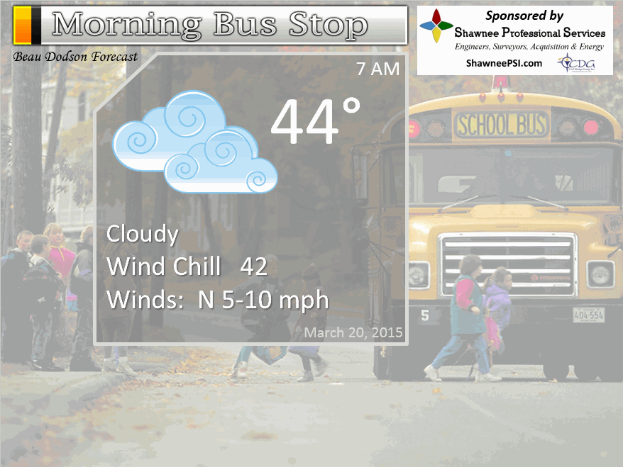
Morning School Bus Stop Weather – Some clouds and cool. Very small chance of a shower (10%-20%) Northwest winds at 5-10 mph. Temperatures Chances of schools being delayed because of the weather zero.
—————————————————————————————-
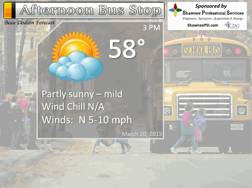
Afternoon School Bus Stop Weather – Mix of sun and clouds. Temperatures in the 50’s to near 60. Light winds.
Friday night – Some clouds and cool. Temperatures in the 40’s by sunrise Saturday morning. Winds from the northwest at 5 mph. My confidence in this part of the forecast verifying is high
Saturday – Pick day of the weekend! Partly sunny and mild! Highs into the 60’s. Variable winds/light. My confidence in this part of the forecast verifying is high
Saturday night – A few clouds and cool. Lows into the 40’s. Winds from the northeast at 5-10 mph. My confidence in this part of the forecast verifying is high
Sunday – Partly sunny and mild. Highs into the 60’s for most areas…perhaps 50’s far northeast counties. Winds from the northeast at 5-10 mph. My confidence in this part of the forecast verifying is high

The School Bus Stop Forecast is brought to your by Shawnee Professional Services. For more information click here
Current Temperatures Around The Local Area


An explanation of what is happening in the atmosphere over the coming days…
Highlights
Welcome to Spring 2015
1. Let’s skip to the good parts (Saturday and Sunday are looking mild). Stellar days?
2. Cooler by Monday, but data has backed off the coldest of air. More good news
3. Maybe some thunderstorms towards the middle and end of next week
Friday is going to bring some clouds during the morning hours. A weak weather system passes through the area with just a small chance for a few showers. Nothing major and most will remain dry. By the afternoon hours we should have a mix of sun and clouds with temperatures rising into the 50’s. If we can get the sun to show up then it won’t feel too bad outside. The late March sun feels great.
I have some great news! Saturday and Sunday now look to be nice. At one time Sunday was going to be quite a bit cooler. But, the latest data points to Sunday bringing 60’s for high temperatures. There could be a nose of 50’s over our northeast counties. There is going to be a cold front in the area.
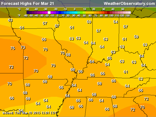
Here are the high temperature forecasts for the weekend!
Saturday – with quite a bit of sun!
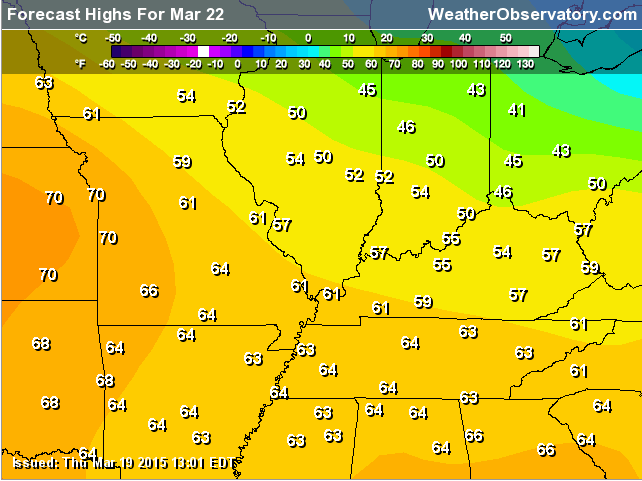
Sunday (below) – a few more clouds on Sunday.
Cooler air for Monday, but the data has backed off the upper 20’s. Now it looks like 30’s will be the rule (for lows on Monday night). Chilly, but bearable. The weak weather system, that was forecast to bring some rain or rain/snow mix to the area, continues to look very weak on the charts. Maybe an isolated shower. Less than 20% chance, at this time.
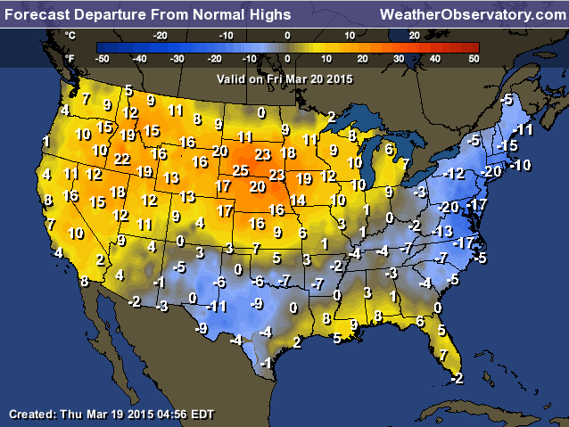
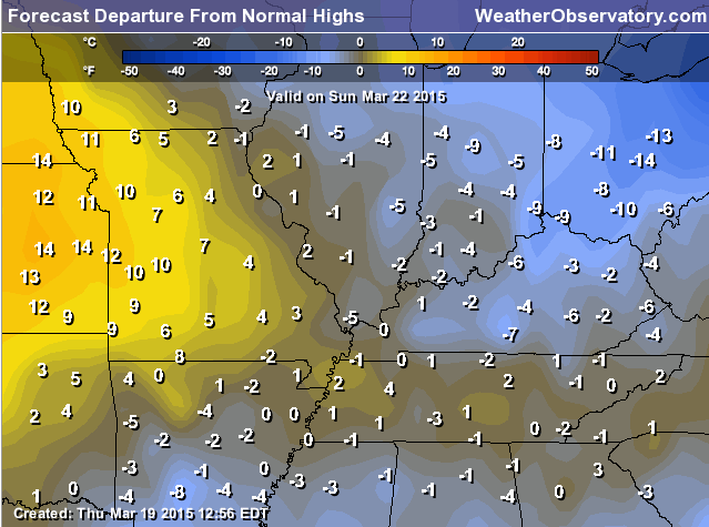
Let’s look at high temperature departures. How much above or below normal with high temperatures be today into Monday?
For today – we are still flirting with below normal readings. But, better than the sleet on Wednesday and the cool temperatures on Thursday.
Today (Friday). The map shows we are close to normal. Within a few degrees of normal, at least.
Saturday (below) – awwww warmer!
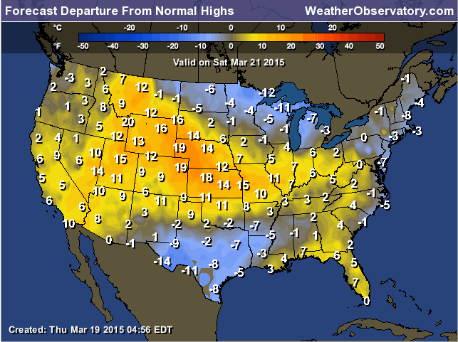
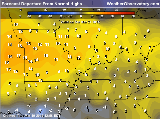
Zoom in a bit for Saturday (just because it looks so great)
Sunday – still above normal (a bit). Perhaps not as impressive as Saturday.
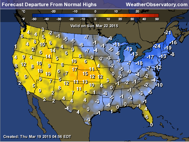
Zoom in a bit on Sunday (below)
And finally Monday – behind that cold front I mentioned.
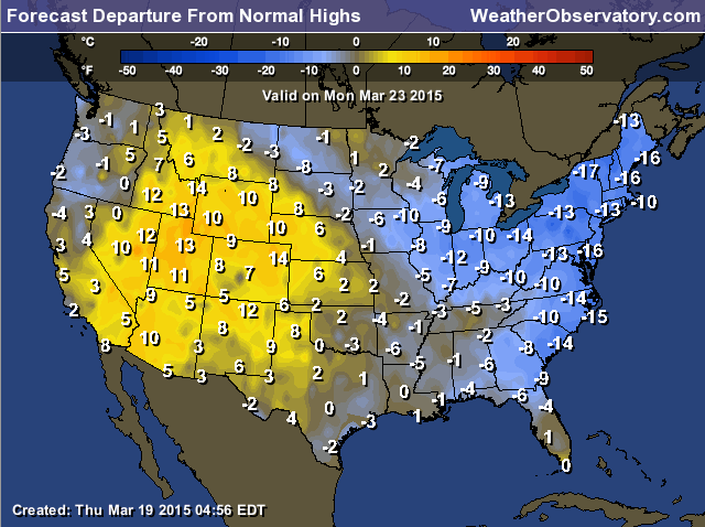
And for good measure, let’s zoom in on Monday (not as great, I know)
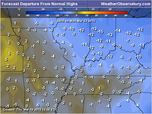
Normal high temperatures for this time of the year are around 60-62 degrees.
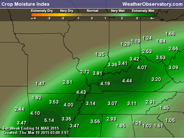
Guessing it would not surprise you that our crop moisture index is extremely wet. Well above the norms.
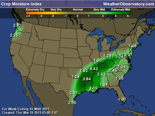
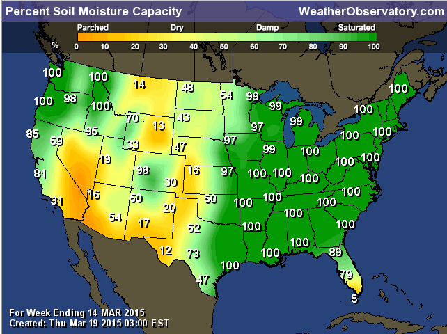
Field moisture capacity (below)
Our next weather maker arrives towards the middle of next week. Showers and thunderstorms appear likely with a cold front.
See the extended discussion below for more information on that part of the forecast.
Don’t forget to support our sponsors!

I increased high temperatures for Sunday. Also raised overnight lows a little bit for the Sunday night into Tuesday morning time frame. Spring is creeping more and more into the forecast. Not finished with cold shots, but hopefully they will become less and less of a problem. Still, not sure we are out of the woods for sub-freezing weather.

No major concerns.
Check out our sponsors! There are more on the right side bar of the page, as well. Be sure and let them know that you appreciate their sponsorship of the WeatherTalk daily weather bulletin.
How about a $5 meal deal? The DQ Grill and Chill (located across from Noble Park in Paducah, Kentucky) is the newest WeatherTalk Blog sponsor! A local business helping to sponsor the weather information that you have come to love so much.
Check out their Facebook page for specials, as well DQ Grill and Chill on Facebook


Premier Portable Buildings proudly serving our region. For more information click the above ad or here
They can also be found on this Facebook page
G&C Multi-Services out of Paducah, Kentucky. G & C Multi-Services is a service provider in Western Kentucky that provides industrial and commercial equipment fabrication, machine troubleshooting, repair and maintenance, and installation. They can custom fabricate steel, stainless, and aluminum products per customer specifications.
Visit their web-site here. Or click the ad below! Facebook page.


Wortham Dental Care located in Paducah, Kentucky. The gentle dentist. Mercury free dentistry. They also do safe Mercury removal. You can find Wortham Dental Care on Facebook, as well

Trover’s Equipment and Lawn Care – Family owned and operated! They are a dealer for Snapper, Simplicity, Snapper Pro, Bad Boy Mowers, and Intimidator Utility Vehicles. They are a Stihl and Dolmar power products dealer. They also are a dealer for Briggs & Stratton, Kohler gas & diesel engines, and Kawasaki engines. They service and repair just about any brand. You can find them on Facebook, as well
The School Bus Stop Forecast is brought to your by Shawnee Professional Services. For more information click here

Shawnee Professional Services & Civil Design Group have been providing Land Surveying, Engineering, Grant Administration and Acquisition services for the past 20 years. Currently Licensed in Illinois, Kentucky, Missouri, Indiana, and Tennessee; please contact Shawnee for any Land Surveying or Engineering needs. Shawnee’s company size allows them to devote individual attention to each client and to approach each project with the required thoroughness to successfully complete the project, large or small. Visit Shawnee’s website at shawneepsi.com for more information. Shawnee has offices in Paducah, KY, Vienna, IL and Benton, IL.

Here are the current river stage forecasts. You can click your state and then the dot for your location. It will bring up the full forecast and hydrograph.
Click Here For River Stage Forecasts…
Here are some current forecast hydrographs. These will be updated each day with new information.


Smithland Lock and Dam

Paducah, Kentucky Forecast Stage

Cairo, Illinois

The wild card tells you where the uncertainties are in the forecast
Wild card in this forecast – high temperatures on Sunday will be the wild card. Appears 60’s will be possible. Saturday remains the pick day of the week. The latest numbers for Sunday, however, don’t look too bad either.

Can we expect severe thunderstorms over the next 24 to 48 hours? Remember that a severe thunderstorm is defined as a thunderstorm that produces 58 mph winds or higher, quarter size hail or larger, and/or a tornado.
Thunderstorm threat level is ZERO (an amazing stretch of time with no severe weather warnings in our region – believe it has been since last October). Very very quiet on the severe weather front.
Friday Severe Weather Outlook – No severe weather expected
Saturday Severe Weather Outlook – No severe weather expected
Sunday Severe Weather Outlook – No severe weather expected
Monday Severe Weather Outlook – No severe weather expected
Tuesday Severe Weather Outlook – No severe weather expected
Wednesday – Friday Severe Weather Outlook – monitoring for at least a chance for thunderstorms (right now the severe weather risk appears minimal)


How much precipitation should we expect over the next few days?
No rain of significance is forecast today through Sunday. Small chance for a light shower Friday morning. If a light shower occurs then it would drop less than 0.10″ of rain.

No winter weather! Removed wording for Monday for light rain/snow mix. Temperatures should be warm enough that if precipitation does occur it would be light rain. Overall the precipitation chances appear small.

This section of the blog is speculative forecast information. Because it is past the range of what meteorologists can forecast accurately, it should be considered speculation. Anything past day 5 is considered a long range forecast.
The big story in the extended forecast will be a cold front that approaches our region on Wednesday-Friday of next week. Some timing issues on the exact placement of the front each day. It does appear to be a slow mover.
Showers and thunderstorms appear almost certain with the front. The overall severe weather risk appears minimal, at this time. However, I would keep checking back on that topic. This time of the year the forecast can change considerably based on how much instability we have. That is something I won’t know until we are closer to the event.
Longer range data continues to show some impressive cold snaps as we move into late March and April. Hard to say just how cold it will be with each cold push. The good news is that the later we push into March and April the higher the normal high and low temperatures are. Each cold shot becomes less impressive and eventually they become cool shots of air vs cold.
Normal highs right now are around 61 degrees and normal lows are around 42 degrees. They keep going up!
Not sure we are finished with sub-freezing weather, yet. I keep watching for a signal that the cold air will return north until next fall. Just not seeing it, yet.

We have regional radars and local city radars – if a radar does not seem to be updating then try another one. Occasional browsers need their cache cleared. You may also try restarting your browser. That usually fixes the problem. Occasionally we do have a radar go down. That is why I have duplicates. Thus, if one fails then try another one.
If you have any problems then please send me an email beaudodson@usawx.com
WEATHER RADAR PAGE – Click here —
We also have a new national interactive radar – you can view that radar by clicking here.
Local interactive city radars include St Louis, Mt Vernon, Evansville, Poplar Bluff, Cape Girardeau, Marion, Paducah, Hopkinsville, Memphis, Nashville, Dyersburg, and all of eastern Kentucky – these are interactive radars. Local city radars – click here
NOTE: Occasionally you will see ground clutter on the radar (these are false echoes). Normally they show up close to the radar sites – including Paducah.

Regional Radar – Click on radar to take you our full radar page.


Regional Radar
![]()
Current WARNINGS (a warning means take action now). Click on your county to drill down to the latest warning information. Keep in mind that there can be a 2-3 minute delay in the updated warning information.
I strongly encourage you to use a NOAA Weather Radio or warning cell phone app for the most up to date warning information. Nothing is faster than a NOAA weather radio.


Color shaded counties are under some type of watch, warning, advisory, or special weather statement. Click your county to view the latest information.

Please visit your local National Weather Service Office by clicking here. The National Weather Service Office, for our region, is located in Paducah, Kentucky. They have a lot of maps and information on their site. Local people…local forecasters who care about our region.


Here is the official 6-10 day and 8-14 day temperature and precipitation outlook. Check the date stamp at the top of each image (so you understand the time frame).
The forecast maps below are issued by the Weather Prediction Center (NOAA).


The latest 8-14 day temperature and precipitation outlook. Note the dates are at the top of the image. These maps DO NOT tell you how high or low temperatures or precipitation will be. They simply give you the probability as to whether temperatures or precipitation will be above or below normal.


Who do you trust for your weather information and who holds them accountable?
I have studied weather in our region since the late 1970’s. I have 37 years of experience in observing our regions weather patterns. My degree is in Broadcast Meteorology from Mississippi State University and an Associate of Science (AS). I am currently working on my Bachelor’s Degree in Geoscience. Just need to finish two Spanish classes!
I am a member of the American Meteorological Society. I am a NOAA Weather-Ready Nation Ambassador. And, I am the Meteorologist for McCracken County Emergency Management.
I own and operate the Southern Illinois Weather Observatory.
There is a lot of noise on the internet. A lot of weather maps are posted without explanation. Over time you should learn who to trust for your weather information.
My forecast philosophy is simple and straight forward.
- Communicate in simple terms
- To be as accurate as possible within a reasonable time frame before an event
- Interact with you on Twitter, Facebook, and the blog
- Minimize the “hype” that you might see on television or through other weather sources
- Push you towards utilizing wall-to-wall LOCAL TV coverage during severe weather events
I am a recipient of the Mark Trail Award, WPSD Six Who Make A Difference Award, Kentucky Colonel, and the Caesar J. Fiamma” Award from the American Red Cross. In 2009 I was presented with the Kentucky Office of Highway Safety Award. I was recognized by the Kentucky House of Representatives for my service to the State of Kentucky leading up to several winter storms and severe weather outbreaks.
If you click on the image below you can read the Kentucky House of Representatives Resolution.

I am also President of the Shadow Angel Foundation which serves portions of western Kentucky and southern Illinois.
Many of my graphics are from www.weatherbell.com – a great resource for weather data, model data, and more


This blog was inspired by ABC 33/40’s Alabama Weather Blog – view their blog
Current tower cam view from the Weather Observatory- Click here for all cameras.

Southern Illinois Weather Observatory

The Weather Observatory

Southern Illinois Weather Observatory
WSIL TV 3 has a number of tower cameras. Click here for their tower camera page & Illinois Road Conditions

Marion, Illinois
WPSD TV 6 has a number of tower cameras. Click here for their tower camera page & Kentucky Road Conditions & Kentucky Highway and Interstate Cameras

Downtown Paducah, Kentucky
Benton, Kentucky Tower Camera – Click here for full view

Benton, Kentucky

I24 Paducah, Kentucky

I24 Mile Point 9 – Paducah, KY

I24 – Mile Point 3 Paducah, Kentucky

You can sign up for my AWARE email by clicking here I typically send out AWARE emails before severe weather, winter storms, or other active weather situations. I do not email watches or warnings. The emails are a basic “heads up” concerning incoming weather conditions.