WeatherTalk monthly operating costs can top $2000.00. Your $3 subscription helps pay for those costs. I work for you.
For $3 a month you can receive the following. You may choose to receive these via your WeatherTalk app or regular text messaging.
- Severe weather app/text alerts from my keyboard to your app/cell phone. These are hand typed by Beau. During tornado outbreaks, you will receive numerous app/text messages telling you exactly where the tornado is located.
- Daily forecast app/texts from my computer to your app/cell phone.
- Social media links sent directly to your app/cell phone. When I update the blog, videos, or Facebook you will receive the link.
- AWARE emails. These emails keep you well ahead of the storm. They give you several days of lead time before significant weather events.
- Direct access to Beau via text and email. Your very own personal meteorologist. I work for you!
- Missouri and Ohio Valley centered video updates
- Long-range weather videos
- Week one, two, three and four temperature and precipitation outlooks.
- Monthly outlooks.
- Your subscription also will help support several local charities.
Haven’t you subscribed? Subscribe at www.beaudodsonweather.com

Example of a recent severe weather alert. I issued this well before the official tornado warning. You would have had plenty of time for you and your family to seek shelter.


Your $3 per month also helps support these local charity projects.

I encourage subscribers to use the app vs regular text messaging. We have found text messaging to be delayed during severe weather. The app typically will receive the messages instantly. I recommend people have three to four methods of receiving their severe weather information.
Remember, my app and text alerts are hand typed and not computer generated. You are being given personal attention during significant weather events.


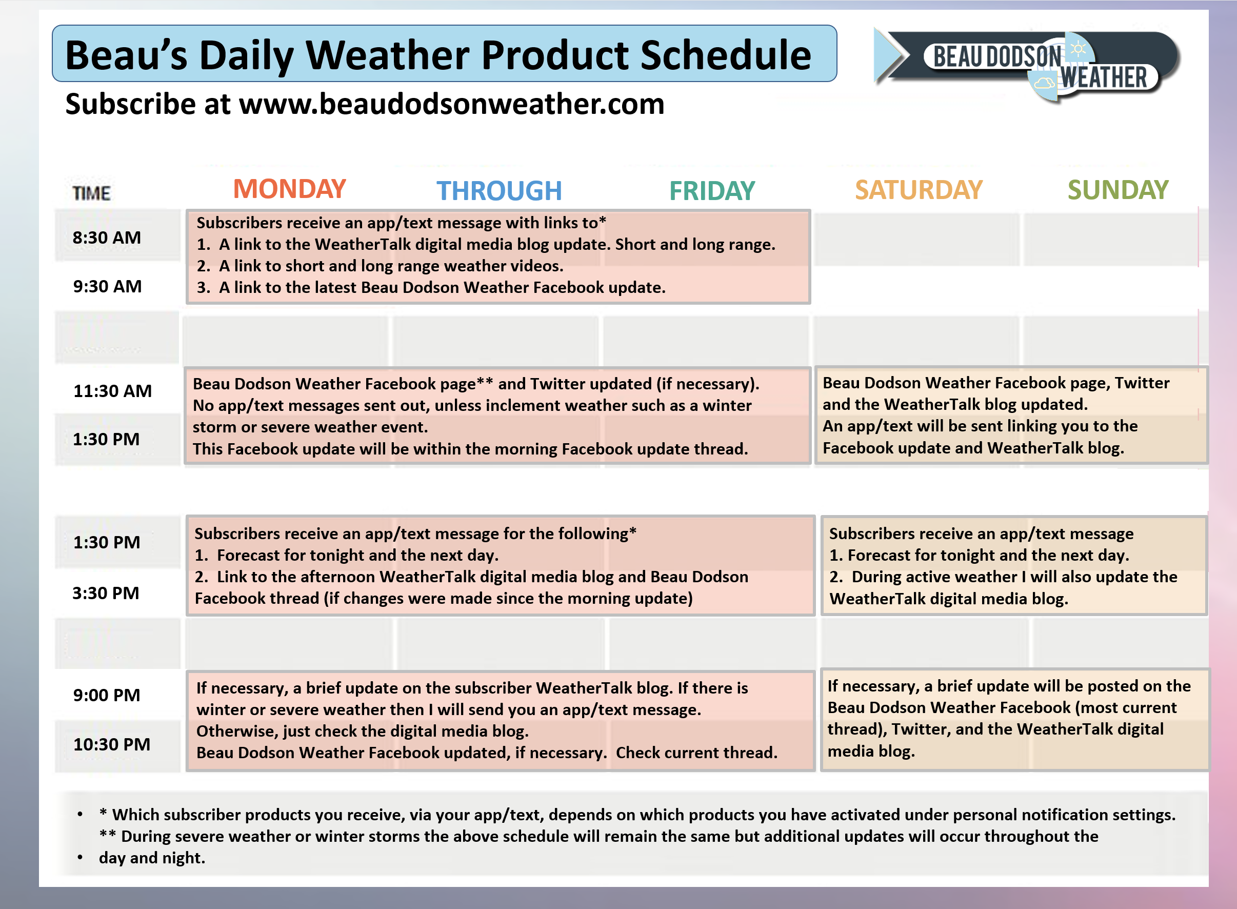
WWW.WEATHERTALK.COM subscribers, here is my day to day schedule for your weather products.

March 18, 2018
Sunday Forecast Details
Forecast: Much cooler. Intervals of clouds. A few showers possible over southeast Missouri late in the day.
Temperatures: 45 to 52 IL ~ 46 to 54 KY ~ 48 to 54 TN ~ 50 to 55
What is the chance of precipitation? MO ~ 30% IL ~ 10% KY ~ 20% TN ~ 10%
Coverage of precipitation: Isolated late in the day and evening.
Winds: East and northeast winds at 5 to 10 mph
What impacts are anticipated from the weather? Perhaps a few wet roads.
My confidence in the forecast verifying: High
Is severe weather expected? No
The NWS defines severe weather as 58 mph wind or great, 1″ hail or larger, and/or tornadoes
Should I cancel my outdoor plans? No
Sunrise 7:00 AM
Sunday Night Forecast Details:
Forecast: Cloudy. Showers and thunderstorms developing. A few strong storms possible in southeast Missouri.
Temperatures: MO ~ 42 to 46 IL ~ 40 to 45 KY ~ 43 to 46 TN ~ 44 to 48
What is the chance of precipitation? MO ~ 70% IL ~ 60% KY ~ 70% TN ~ 70%
Coverage of precipitation: Becoming numerous.
Winds: East and northeast at 6 to 12 mph
What impacts are anticipated from the weather? Wet roadways. Lightning. A small chance of pea to dize size hail with thunderstorms.
My confidence in the forecast verifying: High
Is severe weather expected? Unlikely. I can’t rule out a strong storm over southeast Missouri.
The NWS defines severe weather as 58 mph wind or great, 1″ hail or larger, and/or tornadoes
Should I cancel my outdoor plans? No, early on. As we move through the night the rain chances increase. Monitor radars.
Sunset 7:04 PM
March 19, 2018
Monday Forecast Details
Forecast: Mostly cloudy. Cool north and warmer south. Showers and thunderstorms likely. Some locally heavy downpours possible. Monitor updates concerning severe thunderstorms (mainly southern counties of the region).
Temperatures: MO ~ 54 to 64 IL ~ 52 to 62 Cooler Mt Vernon vs Metropolis KY ~ 55 to 66 (coolest near Owensboro) TN ~ 62 to 68
What is the chance of precipitation? MO ~ 70% IL ~ 70% KY ~ 70% TN ~ 70%
Coverage of precipitation: Perhaps numerous
Winds: East at 10 to 20 mph. Winds may become southeast. Winds variable with fronts in the region. During the afternoon and evening, the winds will become more westerly.
What impacts are anticipated from the weather? Wet roadways. Lightning. Monitor the potential of a few severe thunderstorms.
My confidence in the forecast verifying: High
Is severe weather expected? Yes. Some severe thunderstorms will be possible from the Missouri Bootheel into western Kentucky and Tennessee. The greatest risk will be along and south of the Kentucky and Tennessee State line.
The NWS defines severe weather as 58 mph wind or great, 1″ hail or larger, and/or tornadoes
Should I cancel my outdoor plans? Have a plan B
Sunrise 6:59 AM
Monday Night Forecast Details:
Forecast: Cloudy. Showers and thunderstorms likely early. Light rain or rain/snow mix late at night (no travel issues if it happens). Turning colder. Breezy. Rain chances will be highest early in the night and lesser chances as we move through the night. Monitor updates concerning the potential of severe thunderstorms during the evening in Kentucky and Tennessee.
Temperatures: MO ~ 32 to 36 IL ~ 32 to 38 KY ~ 34 to 40 TN ~ 38 to 44
What is the chance of precipitation? MO ~ 40% before 7 PM and then 20% IL ~ 40% before 7 PM and then 20% KY ~ 60% before 8 PM and then 30% TN ~ 60% before 8 PM and then 30%
Coverage of precipitation: Scattered to numerous early. Becoming widely scattered late.
Winds: North and northwest at 6 to 12 mph with gusts to 20 mph
What impacts are anticipated from the weather? Wet roadways. Lightning. Monitor updates concerning severe storms along the Kentucky and Tennessee border early in the evening.
My confidence in the forecast verifying: Medium
Is severe weather expected? Yes. There is the potential of a few severe thunderstorms near the Kentucky and Tennessee State line.
The NWS defines severe weather as 58 mph wind or great, 1″ hail or larger, and/or tornadoes
Should I cancel my outdoor plans? Have a plan B.
Sunset 7:05 PM
March 20, 2018
Tuesday Forecast Details
Forecast: Quite a few clouds. Breezy. Patchy light rain possible. I can’t rule out a stray wet snowflake, but no accumulation.
Temperatures: MO ~ 44 to 50 IL ~ 43 to 46 KY ~ 44 to 48 TN ~ 45 to 50
What is the chance of precipitation? MO ~ 30% IL ~ 30% KY ~ 30% TN ~ 30%
Coverage of precipitation: Isolated to scattered. Low confidence.
Winds: North at 10 to 20 mph with higher gusts likely.
What impacts are anticipated from the weather? Most likely none.
My confidence in the forecast verifying: Medium
Is severe weather expected? No
The NWS defines severe weather as 58 mph wind or great, 1″ hail or larger, and/or tornadoes
Should I cancel my outdoor plans? No
Sunrise 6:57 AM
Tuesday Night Forecast Details:
Forecast: Some clouds. A chance of patchy light rain or flurries. Cold. Frost and/or freeze possible.
Temperatures: MO ~ 28 to 34 IL ~ 28 to 34 KY ~ 28 to 34 TN ~ 30 to 35
What is the chance of precipitation? MO ~ 10% IL ~ 30% KY ~ 30% TN ~ 20%
Coverage of precipitation: Scattered
Winds: North and northwest at 6 to 12 mph with gusts to 18 mph
What impacts are anticipated from the weather? Frost or freeze possible. Wet roadways possible.
My confidence in the forecast verifying: Medium
Is severe weather expected? No
The NWS defines severe weather as 58 mph wind or great, 1″ hail or larger, and/or tornadoes
Should I cancel my outdoor plans? Nom, but monitor radars and updates.
Sunset 7:06 PM
March 21, 2018
Wednesday Forecast Details
Forecast: Partly sunny. Cool.
Temperatures: MO ~ 50 to 55 IL ~ 46 to 52 KY ~ 48 to 54 TN ~ 50 to 54
What is the chance of precipitation? MO ~ 0% IL ~ 0% KY ~ 0% TN ~ 0%
Coverage of precipitation: Most likely none
Winds: Northwest 6 to 12 mph with gusts to 18 mph
What impacts are anticipated from the weather? Most likely none
My confidence in the forecast verifying: Medium
Is severe weather expected? No
The NWS defines severe weather as 58 mph wind or great, 1″ hail or larger, and/or tornadoes
Should I cancel my outdoor plans? No
Sunrise 6:56 AM
Wednesday Night Forecast Details:
Forecast: Mostly clear. Cold. Frost and/or freeze possible. Some increase in clouds late.
Temperatures: MO ~ 28 to 34 IL ~ 28 to 34 KY ~ 30 to 34 TN ~ 32 to 36
What is the chance of precipitation? MO ~ 10% IL ~ 10% KY ~ 0% TN ~ 0%
Coverage of precipitation: None
Winds: North and northeast at 4 to 8 mph
What impacts are anticipated from the weather? Frost or freeze possible
My confidence in the forecast verifying: Medium
Is severe weather expected? No
The NWS defines severe weather as 58 mph wind or great, 1″ hail or larger, and/or tornadoes
Should I cancel my outdoor plans? No
Sunset 7:07 PM
March 22, 2018
Thursday Forecast Details
Forecast: Partly sunny.
Temperatures: MO ~ 52 to 56 IL ~ 50 to 55 KY ~ 50 to 55 TN ~ 52 to 56
What is the chance of precipitation? MO ~ 0% IL ~ 0% KY ~ 0% TN ~ 0%
Coverage of precipitation: None
Winds: East and northeast at 5 to 10 mph
What impacts are anticipated from the weather? None
My confidence in the forecast verifying: Medium
Is severe weather expected? No
The NWS defines severe weather as 58 mph wind or great, 1″ hail or larger, and/or tornadoes
Should I cancel my outdoor plans? No
Sunrise 6:54 AM
Thursday Night Forecast Details:
Forecast: Increasing clouds. I will monitor precipitation chances late at night.
Temperatures: MO ~ 35 to 40 IL ~ 32 to 38 KY ~ 34 to 38 TN ~ 34 to 38
What is the chance of precipitation? MO ~ 20% IL ~ 20% KY ~ 10% TN ~ 10%
Coverage of precipitation: Isolated
Winds: Variable at 4 to 8 mph
What impacts are anticipated from the weather? Wet roadways.
My confidence in the forecast verifying: LOW
Is severe weather expected? No
The NWS defines severe weather as 58 mph wind or great, 1″ hail or larger, and/or tornadoes
Should I cancel my outdoor plans? No
Sunset 7:08 PM
March 23, 2018
Friday Forecast Details
Forecast: Cloudy. Scattered showers and possibly a thunderstorm. Low confidence in rain chances.
Temperatures: MO ~ 54 to 58 IL ~ 54 to 58 KY ~ 54 to 58 TN ~ 55 to 60
What is the chance of precipitation? MO ~ 40% IL ~ 40% KY ~ 40% TN ~ 40%
Coverage of precipitation:
Winds: Southeast at 7 to 14 mph and gusty
What impacts are anticipated from the weather? Wet roadways. Lightning.
My confidence in the forecast verifying: LOW
Is severe weather expected? Unlikely
The NWS defines severe weather as 58 mph wind or great, 1″ hail or larger, and/or tornadoes
Should I cancel my outdoor plans? No, but I would monitor updates.
Sunrise 6:53 AM
Friday Night Forecast Details:
Forecast: Cloudy. A chance of showers and thunderstorms.
Temperatures: MO ~ 42 to 48 IL ~ 40 to 45 KY ~ 42 to 46 TN ~ 42 to 46
What is the chance of precipitation? MO ~ 40% IL ~ 40% KY ~ 40% TN ~ 40%
Coverage of precipitation: Scattered.
Winds: South and southeast at 7 to 14 mph
What impacts are anticipated from the weather? Wet roadways. Lightning.
My confidence in the forecast verifying: LOW
Is severe weather expected? Monitor updates
The NWS defines severe weather as 58 mph wind or great, 1″ hail or larger, and/or tornadoes
Should I cancel my outdoor plans? Monitor updates
Sunset 7:08 PM
March 24, 2018
Saturday Forecast Details
Forecast: Cloudy. Showers and thunderstorms possible. I will be monitoring the timing of a cold front. The front will be key to rain chances.
Temperatures: MO ~ 62 to 66 IL ~ 60 to 65 KY ~ 60 to 65 TN ~ 60 to 65
What is the chance of precipitation? MO ~ 40% IL ~ 40% KY ~ 40% TN ~ 40%
Coverage of precipitation: Scattered to perhaps numerous depending on the timing of the frontal passage.
Winds: South and southwest at 8 to 16 mph. Becoming west at 7 to 14 mph and gusty.
What impacts are anticipated from the weather? Wet roadways. Lightning.
My confidence in the forecast verifying: LOW
Is severe weather expected? Monitor updates
The NWS defines severe weather as 58 mph wind or great, 1″ hail or larger, and/or tornadoes
Should I cancel my outdoor plans? Monitor updates.
Sunrise 6:51 AM
Saturday Night Forecast Details:
Forecast: Cloudy. Rain ending. Turning cooler.
Temperatures: MO ~ 40 to 45 IL ~ 40 to 45 KY ~ 40 to 45 TN ~ 40 to 45
What is the chance of precipitation? MO ~ 20% IL ~ 30% KY ~ 30% TN ~ 30%
Coverage of precipitation:
Winds:
What impacts are anticipated from the weather?
My confidence in the forecast verifying: LOW
Is severe weather expected?
The NWS defines severe weather as 58 mph wind or great, 1″ hail or larger, and/or tornadoes
Should I cancel my outdoor plans?
Sunset 7:09 PM

Questions? Broken links? Other?
You may email me at beaudodson@usawx.com

The National Weather Service defines a severe thunderstorm as one that produces quarter size hail or larger, 58 mph winds or greater, and/or a tornado.
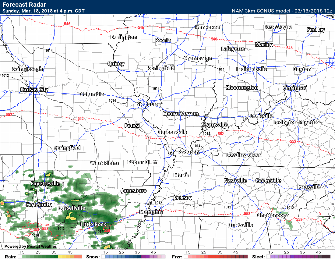
Today and tonight: Severe weather is unlikely. There will be a chance for a few thunderstorms late tonight. I can’t completely rule out a couple of reports of small hail, but organized severe weather appears unlikely. The best chance of a heavier thunderstorm would be over southeast Missouri.

Monday and Monday evening: A storm system will pass through our region with showers and thunderstorms. The greater risk of severe weather will likely remain to our south and southeast.
The main warm front should drape itself through northern and central Arkansas and then into central Tennessee.
It is along and south of this front where the large hail and tornado risk is higher.
There will be a boundary across our region, as well. Some thunderstorms will be possible. A few reports of high winds and hail are a possibility. The main concern will be the Missouri Bootheel into western Kentucky and northwest Tennessee.
Monitor updates on Monday.
Monday night through Friday: Severe weather is not anticipated.
![]()
Interactive live weather radar page. Choose the city nearest your location. If one of the cities does not work then try a nearby one. Click here.
National map of weather watches and warnings. Click here.
Storm Prediction Center. Click here.
Weather Prediction Center. Click here.

Live lightning data: Click here.

Interactive GOES R satellite. Track clouds. Click here.

Here are the latest local river stage forecast numbers Click Here.
Here are the latest lake stage forecast numbers for Kentucky Lake and Lake Barkley Click Here.

The spring and preliminary summer outlooks have been posted for subscribers. Scroll down to see the outlook.
Not a subscriber? Learn more at this link.

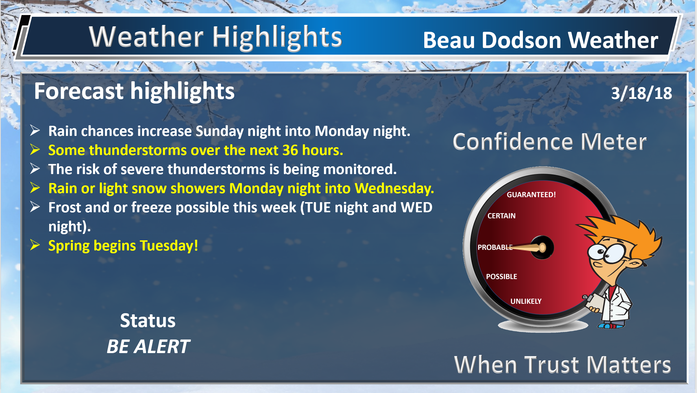
WEATHER HIGHLIGHTS
- Clouds today. Cooler.
- Shower chances ramp up tonight into Monday night.
- Colder weather returns.
- In case you missed it! Here is the Facebook thread with some exciting new announcements concerning Weather Talk. Click here to read that.
Highlights
What has changed over the last 24 hours?
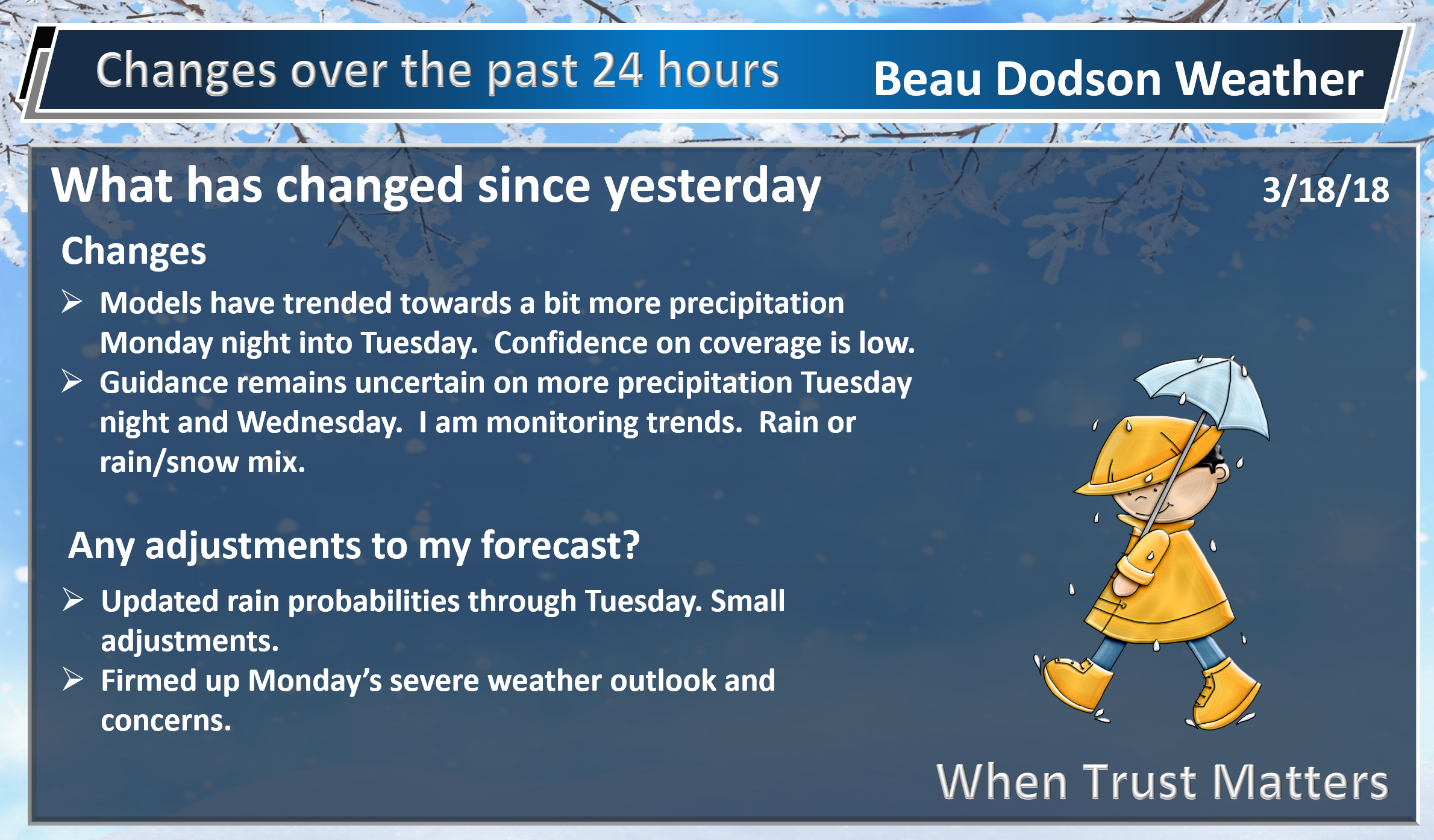
Weather Hazards.
Certainties and uncertainties
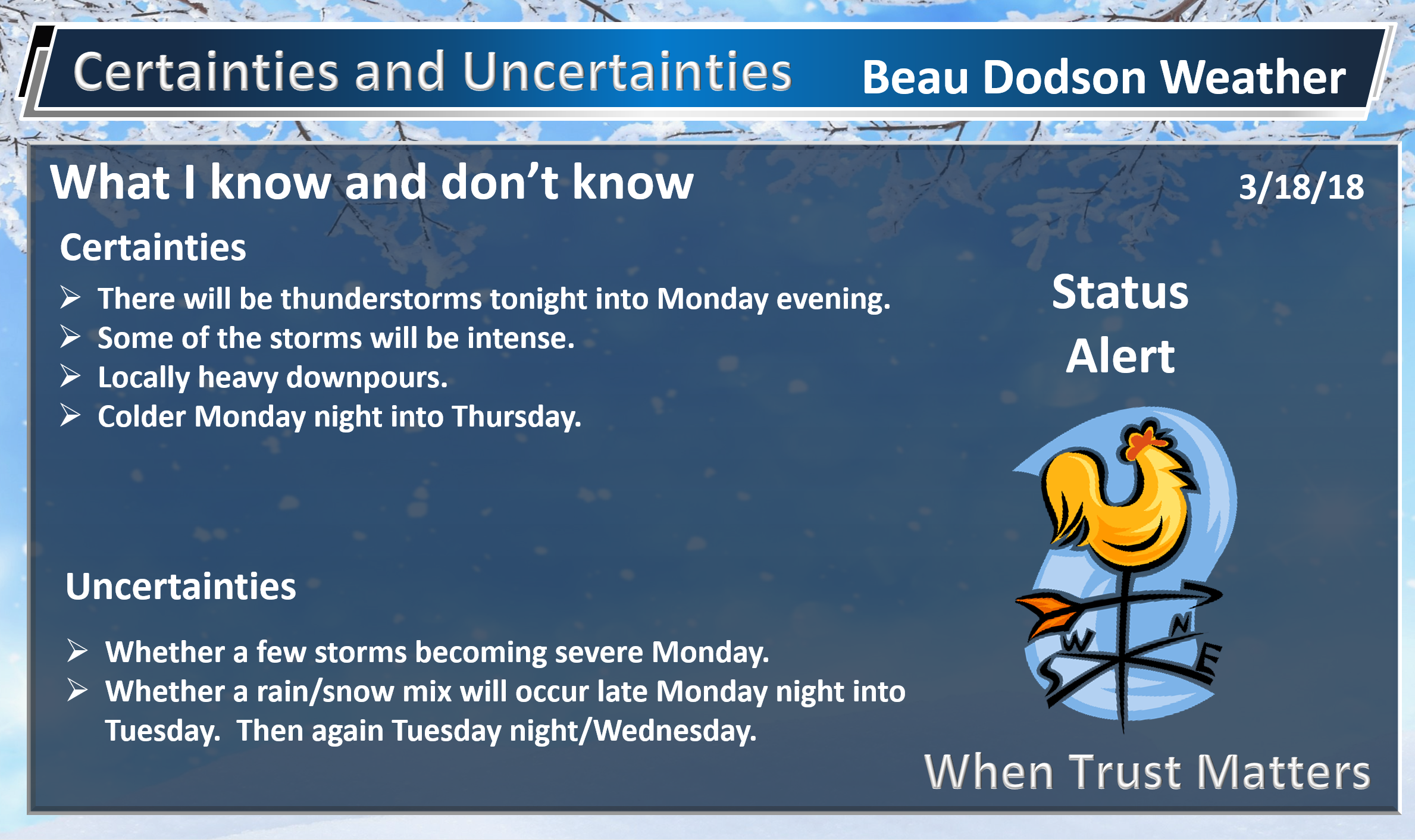
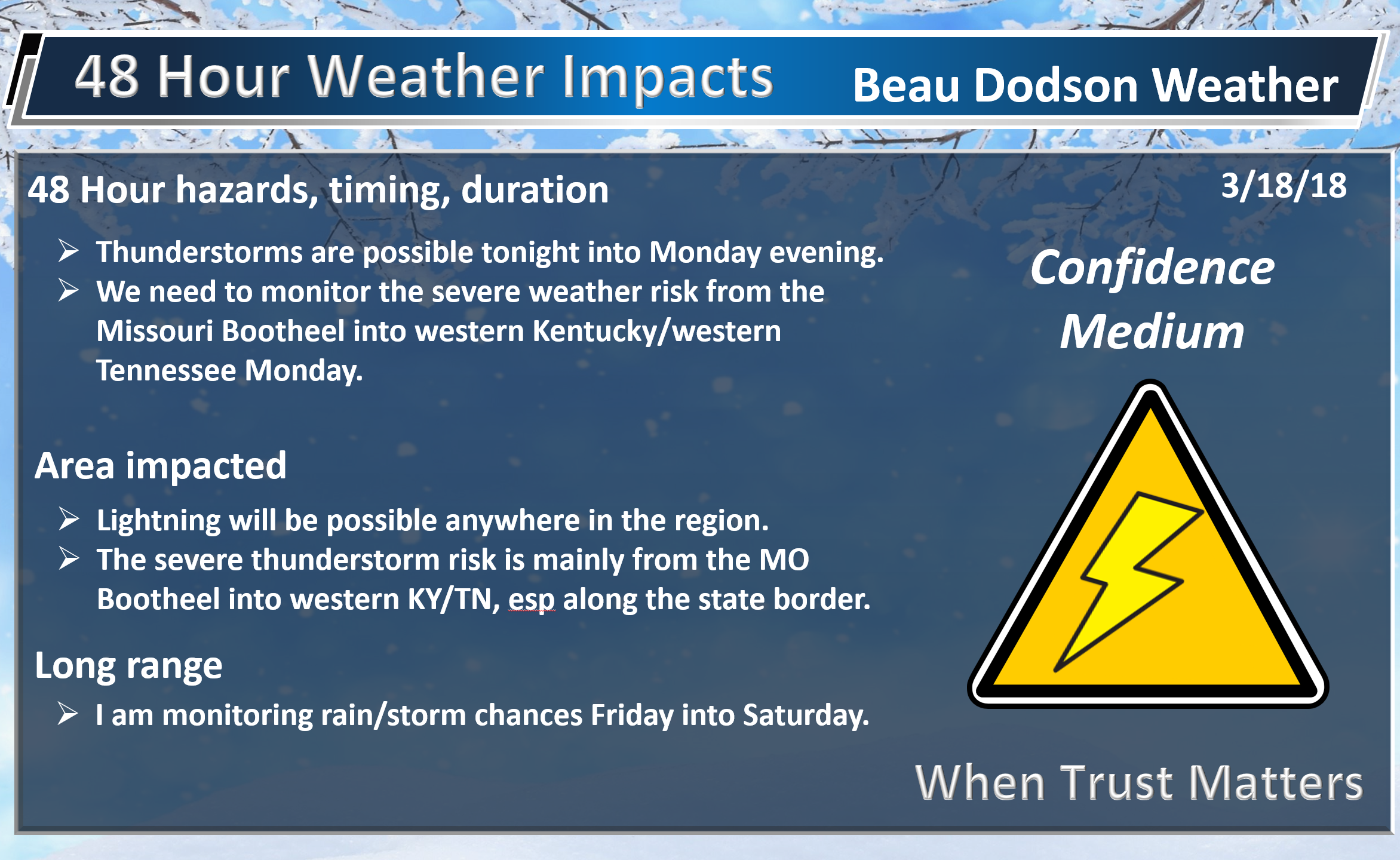
The big weather story over the next 48 hours will be an incoming storm system from Oklahoma and Texas.
An area of low pressure will move from the Missouri, Oklahoma, and Arkansas border eastward late Sunday night into Monday afternoon.
A cold front will trail from the area of low pressure and a warm front will be draped ahead of it.
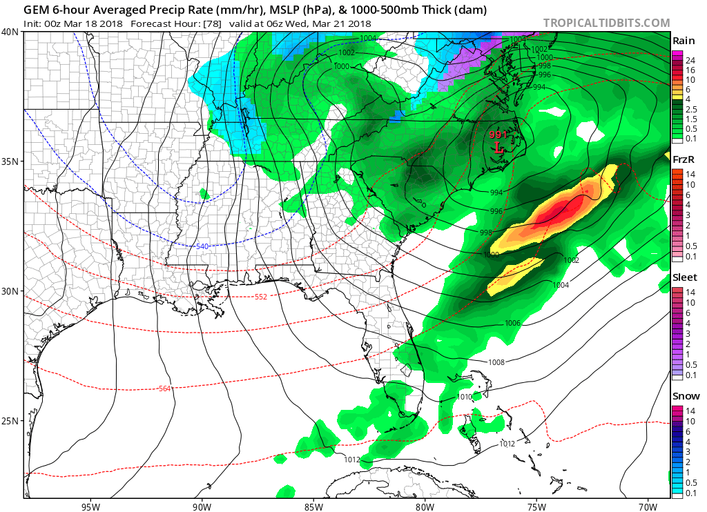
Here is the latest NOAA weather map. This is 7 AM Monday. The low is situated over northeast Oklahoma. It is moving east.
The warm front is well to our south (red half circles). The warm front will lift northward during the day. It will reach Tennessee during the late morning and afternoon hours. It is currently forecast to remain south of the Kentucky border (but it might be close).
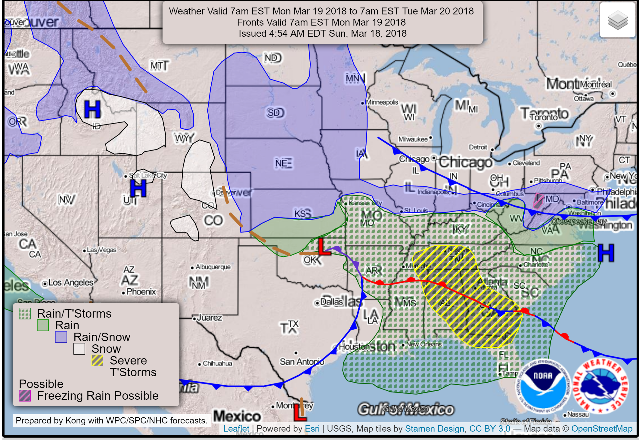
If the low remains to our south then so will the bulk of the severe weather concerns. The low is forecast to track into or near the Missouri Bootheel and the Kentucky/Tennessee border. This places us in or close to the severe weather threat zone.
Typically, severe weather is situated along and south of the warm front. That means east/southeast of the area of low pressure.
Severe Weather Potential:
This will be a close call for our local area.
As it stands, there is some risk of severe thunderstorms from the Missouri Bootheel into western Kentucky and western Tennessee.
The greatest instability Monday will be located to our south. There will be some instability in our region, as well.
Will it be enough for a few severe thunderstorms? It is possible. I would encourage you to monitor updates. Remember, it only takes one severe thunderstorm to cause problems.
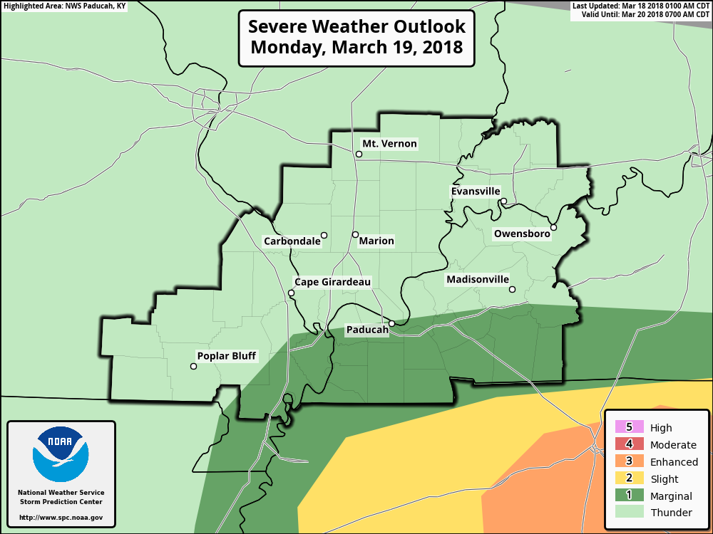
Here is the latest Storm Prediction Center severe weather outlook (see their latest outlook at this link click here)
** These outlooks often shift around a bit as new data becomes available **
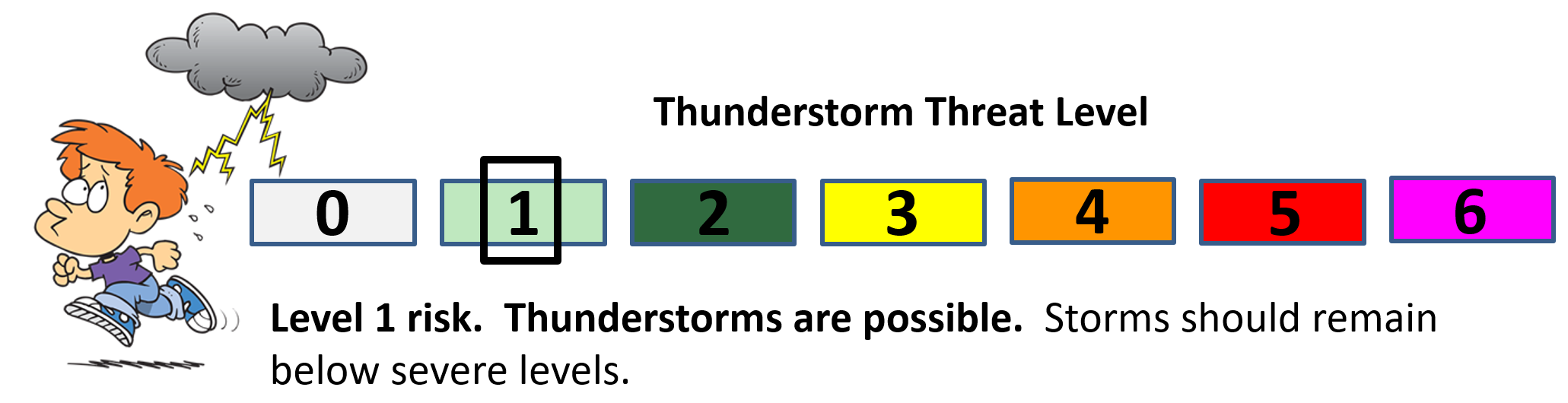
What do the colors mean on this next map?
This is the official severe weather outlook from the SPC (they are in charge of these outlooks and watches). Local NWS offices are in charge of the warnings. SPC is national. NWS is local.
The light green zone is where general thunderstorms are anticipated. Storms in this region should remain below severe levels.
The dark green zone is the level one out of five risk area. One being the lowest risk. Five being the highest risk.
The yellow is the level two out of five risk zone.
The orange is the level three out of five risk zone.
This map will be updated several times between now and Monday. Monitor updates.
Let’s take a look at some more maps.
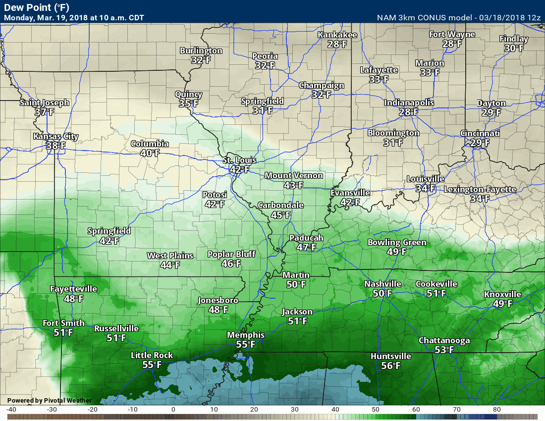
This is the dew point animation. Dew points are a measure of moisture in the lower levels of the atmosphere. Higher dew points mean a greater risk of severe weather.
When considering severe weather, I normally watch for 58-degree dew points and above.
Notice the spike in dew points across the Missouri Bootheel and then along and south of the Kentucky border.
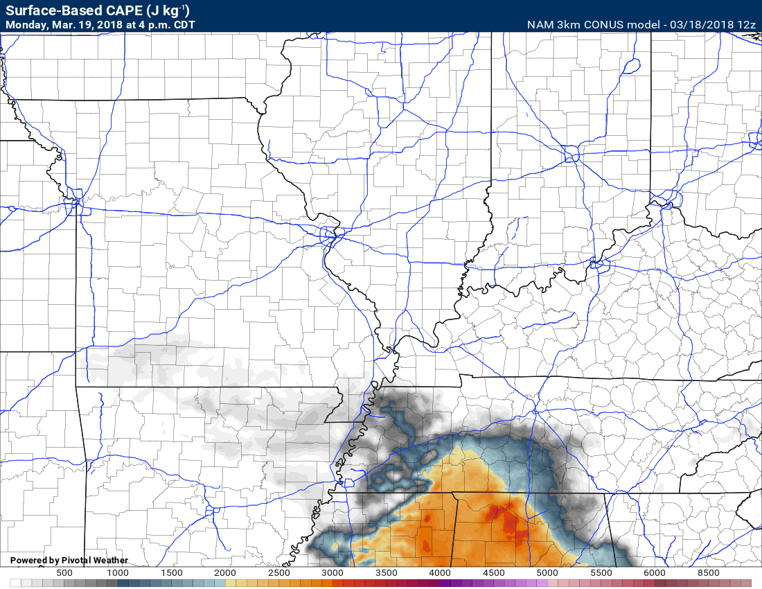
Let’s take a look at CAPE.
What is CAPE? CAPE is a measure of instability in the atmosphere. Higher CAPE would mean an increased risk of severe thunderstorms. CAPE is basically energy for thunderstorms to tap into.
CAPE is a measure of potential thunderstorm energy that uses actual and calculated temperatures and humidity at all altitudes up to more than 40,000 feet. In other words, CAPE estimates the “fuel” available to accelerate air upward.
The faster and farther the air goes up, the stronger thunderstorms can be.
CAPE doesn’t say whether that day’s thunderstorms will even form, much less tap all of the potential energy, but it’s a good measure of the potential danger if thunderstorms form
Multiply CAPE by two and take the square root of the answer for updraft speed in meters per second. This is a rough guess of possible updraft speeds, but it gives you an idea of how fierce thunderstorms could be on a particular day.
For example, if the CAPE is 1,000, you could expect updrafts of approximately 100 mph.
Another rule of thumb is that a thunderstorm’s downdrafts will be about half as fast as the updrafts. Thanks to Capital Weather Gang for that explanation.
Here is the 4 PM CAPE forecast map. Notice the higher CAPE well to our south. A small amount of CAPE locally.
There may be just enough CAPE to warrant our attention.
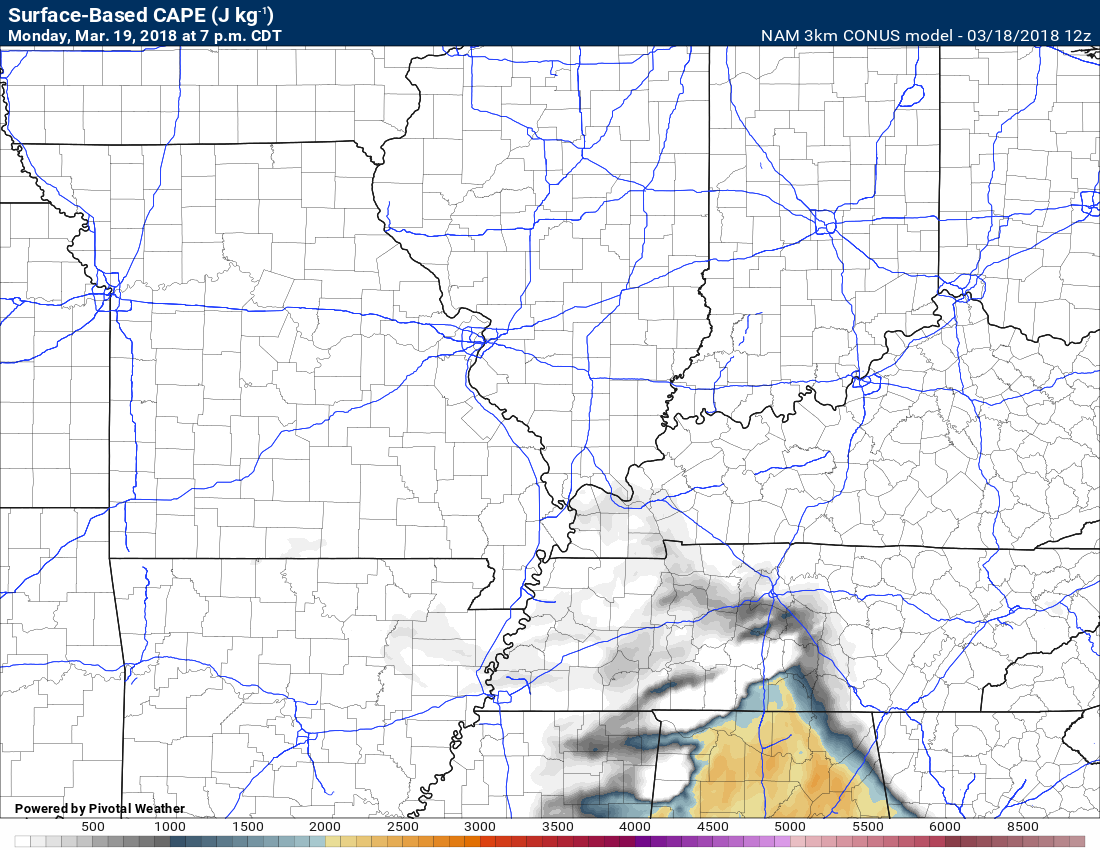
7 PM CAPE (the system will be moving away from our region Monday evening).
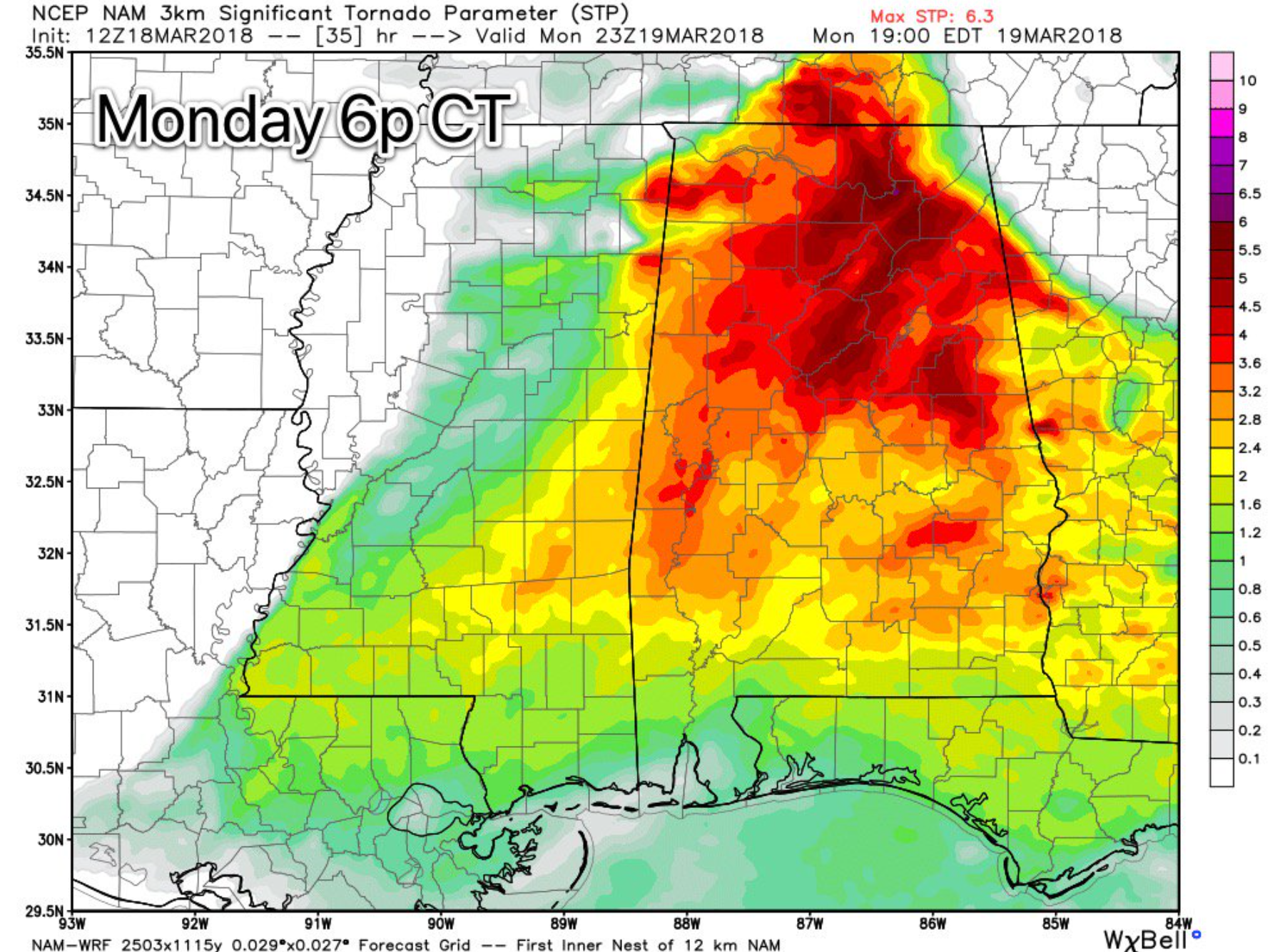
Let’s look at the significant tornado parameter. Another map that meteorologists can use to consider the potential of the atmosphere.
There are some pretty big numbers well to our south. There are certainly concerns that a few tornadoes could occur Monday. This is especially true as you move further south into Tennessee, Mississippi, and Alabama.
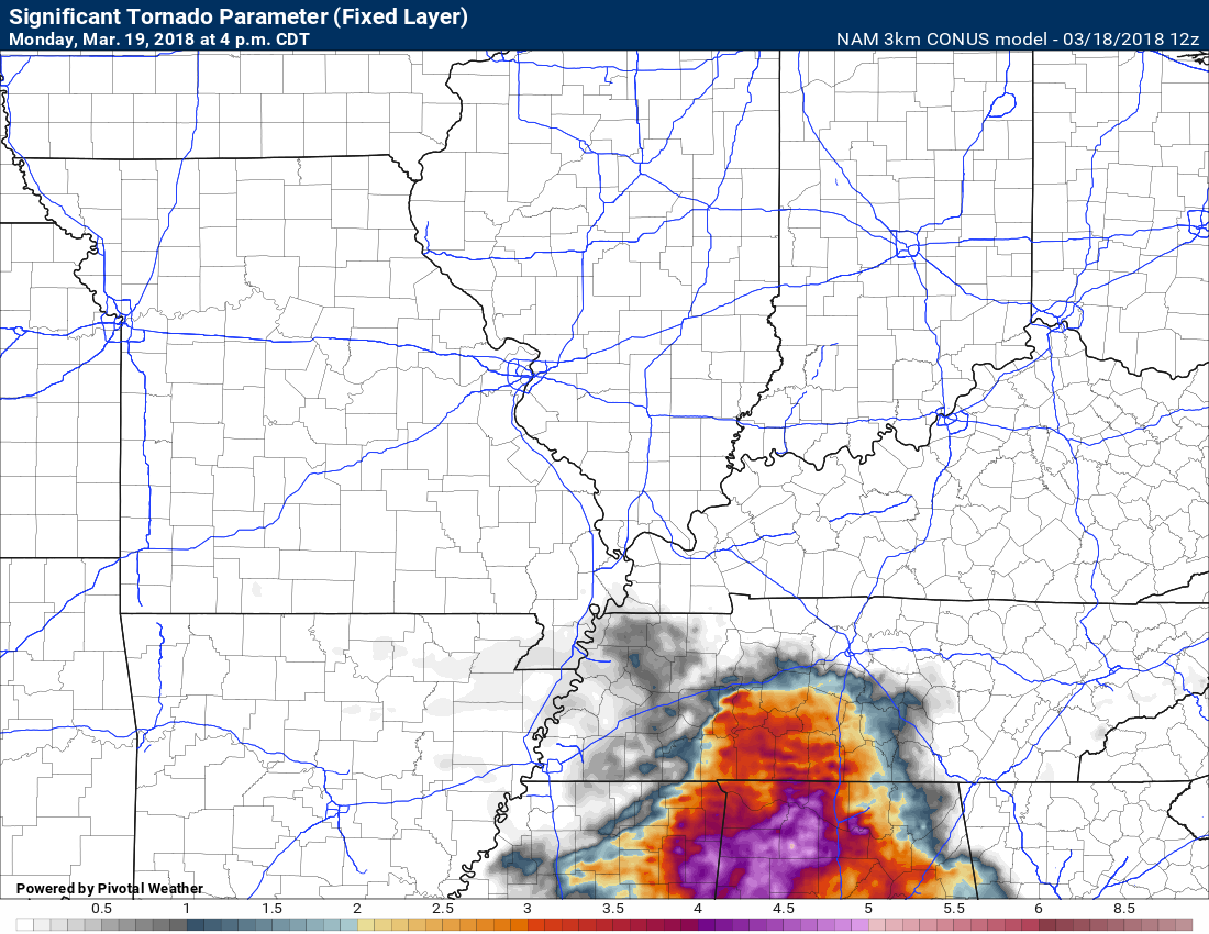
James Spann posted this significant tornado parameter amp. Big numbers down south.
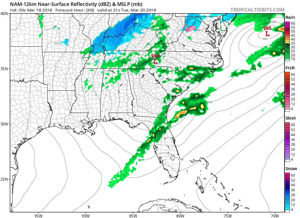
Here is the future-cast radar from the NAM guidance.
Notice the NAM wraps cold air in behind our area of low pressure. It even has rain and snow showers late Monday night and Tuesday morning.
Green is rain. Dark green is moderate rain, Yellow and orange are heavier rain showers and thunderstorms. Blue is snow. Red is a wintry mix.
One band of rain moves through our region during the overnight hours (Sunday night). Then a lull.
Another band of showers and thunderstorms will form ahead of the cold front. That will most likely occur during the late morning and afternoon.
Then, as the system pulls away, some wrap-around rain and snow showers will be possible Monday night into Tuesday.
The timestamp is located in the upper left portion of this animation.
Here is another model that I like to use during active weather. This is from the NSSL. It does well with convection. Again, the timestamp is located in the upper left portion of the graphic.
I noticed that this model is showing several potential supercell thunderstorms across the Tennessee Valley.

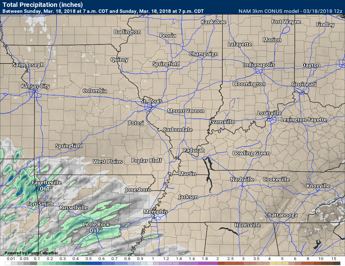
Here is the NAM guidance rain totals animation. Generally, rain totals in our region should range from 0.40″ to 0.80″. There will be bands of greater than 0.80″.
Remember, thunderstorms can easily double a rainfall forecast. Especially if a few thunderstorms track over the same area.
It is that time of the year.
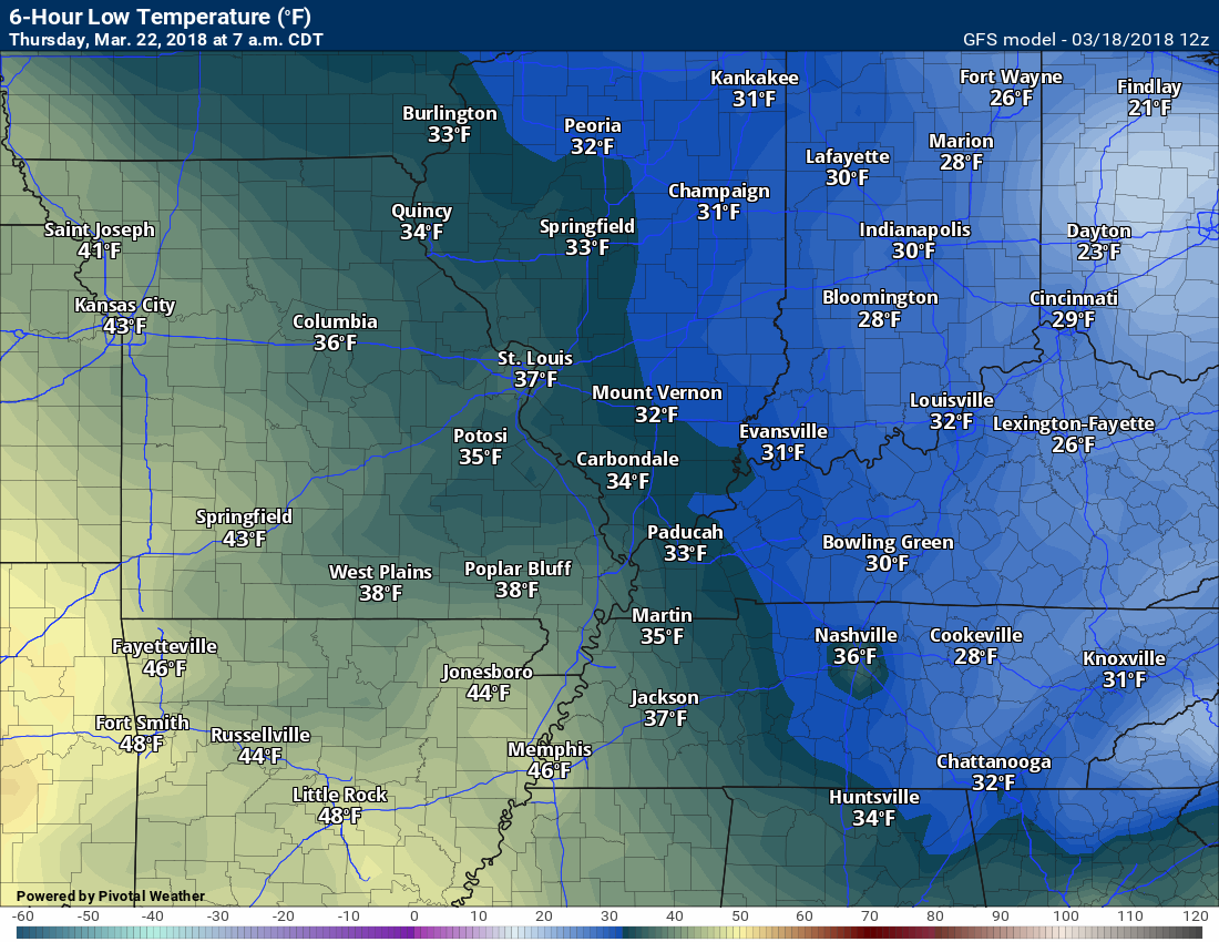
Colder weather arrives Tuesday into Thursday.
A frost/freeze is possible Tuesday and Wednesday night. Part of this will depend on cloud cover and winds. Either way, it will still be cold.
This is not unusual. We typically have frost and freeze conditions until late March. It becomes more of an issue during April.
Some of the guidance is showing another system moving through our region Tuesday night and Wednesday. Confidence on this system is low.
It might be cold enough for snow to mix in with the rain. No accumulation. Just a reminder it is going to be cold.
Here is the NAM model guidance for Tuesday afternoon. You can see some snow locally.
I am not sold on this happening. I am just showing you what the model is spitting out.
Here is the GEM model guidance Tuesday night. Some rain or rain/snow mix showing up in the charts.
Again, confidence in this happening is low.
Let’s learn a bit more about cold fronts, warm fronts, low pressure centers, and dew points.
Here is an example (remember all rules have exceptions).
This is NOT tomorrow’s weather map. This is just an example.
The big red L is the area of low pressure. Low pressure usually means unsettled weather.
Remember, an area of low pressure rotates counter-clockwise. That means if you are to the right of the area of low pressure the wind will be southerly. This draws moisture northward from the Gulf of Mexico. That is why it is normally more unstable to the east/southeast of an area of low pressure.
The backside of the low is usually the cold/cooler region. That is because the winds switch to a northerly direction.
During winter you will have heavy snow to the north, northwest, and west of the area of low pressure.
Here is an example. The L is the low-pressure center. The red half circles would be the warm front. The blue triangles would be the cold front. The arrows represent wind flow around the low-pressure center.
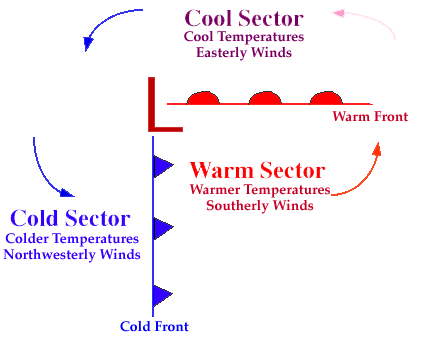
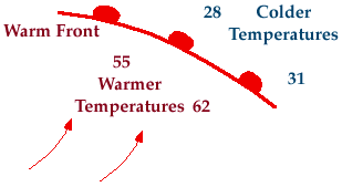
Typically a warm front is located to the east and southeast of the low-pressure center. Sometimes the warm front will budge northward like an upside down U.
Warm and moist air (higher temperatures and higher dew points) are located to the south of the warm front. That is where the severe weather risk is higher.
Can you find the warm front on this dew point map?
This is the dew point map for tomorrow (Monday). The richer moisture is south of the warm front.
The main warm front (sometimes you can have two) should drape itself somewhere from central and northeast Arkansas into central Tennessee.
Dew points are a better measure of moisture than relative humidity.
Those 60’s in west Tennessee represent quite a bit of moisture.

Learn more about dew points.
Occasionally, you can have outbreaks of tornadoes northwest of the area of low pressure, but those are exceptions. We call those cold core tornado events. Save that for another day.
What is the triple point?
Meteorologist call the meeting point of the warm front, low-pressure center, and cold front as the triple point. Often times, severe weather can occur in this area.
If the warm front remains south of you then your risk of severe weather typically diminishes. Especially the wind damage and tornado potential.
You can have elevated instability (CAPE or energy for thunderstorms to tap into) north of the warm front. This often times can lead to hail storms (if all other conditions are favorable).
If a storm rides along the warm front then it can become tornadic or severe, as well.

The information below was posted Saturday, but in case you missed it.
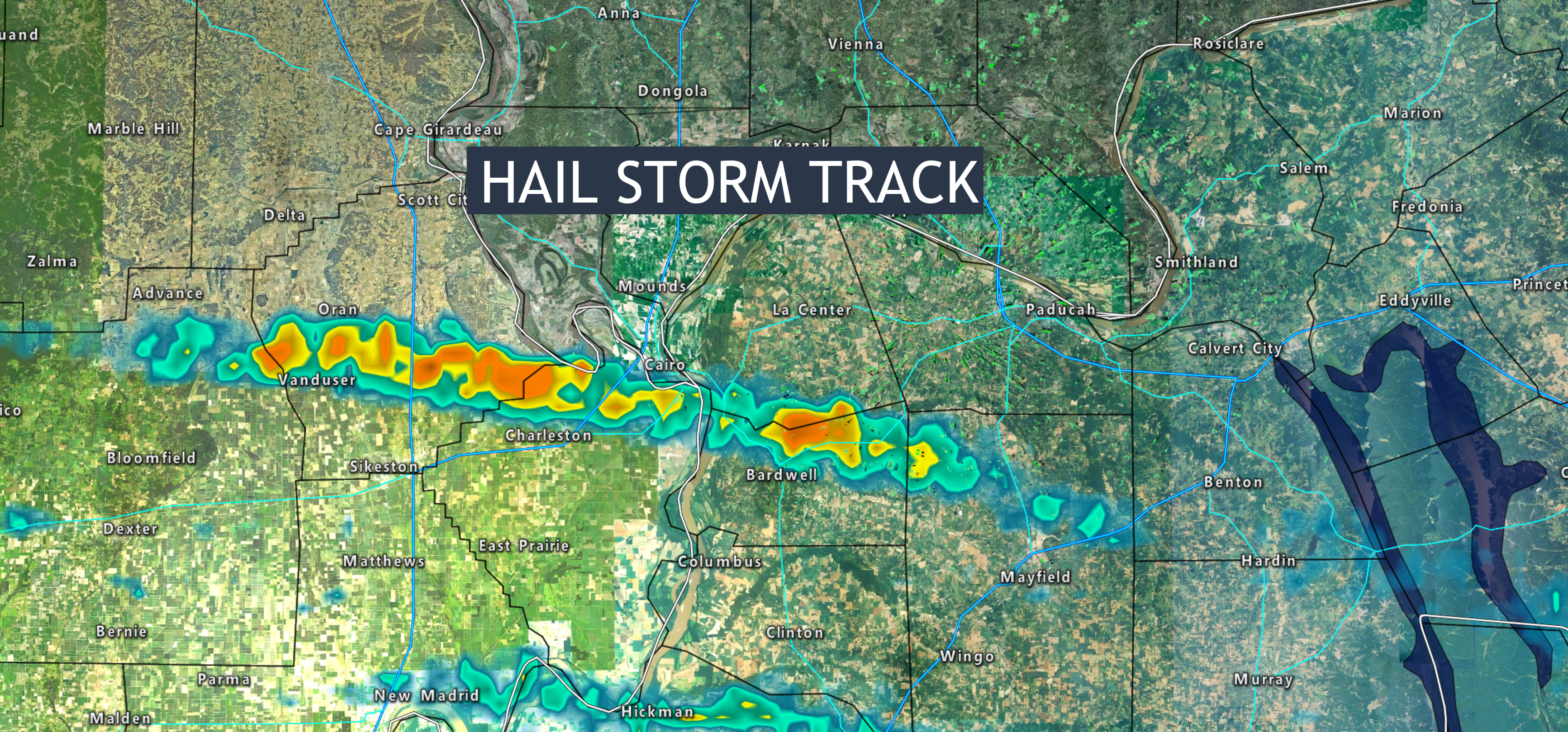
Friday Night Hailstorm.
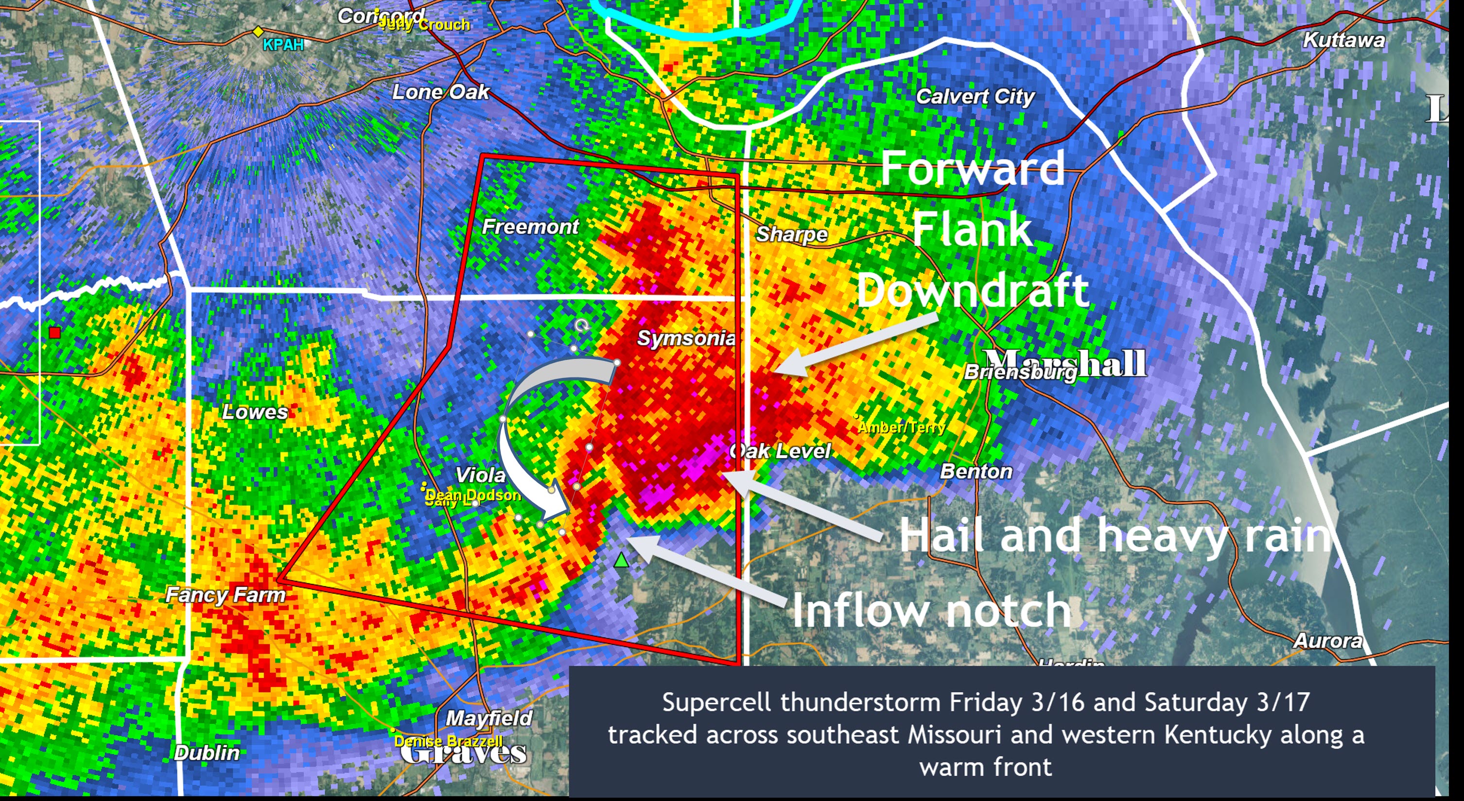
A supercell thunderstorm tracked across southeast Missouri and western Kentucky. Hail was reported in at least nine counties.
The largest hail fell over northern Graves County, Kentucky. Golf ball size hail was reported.
Here is a photograph from northern Graves County, Kentucky.

Here was the path of the hail storm.
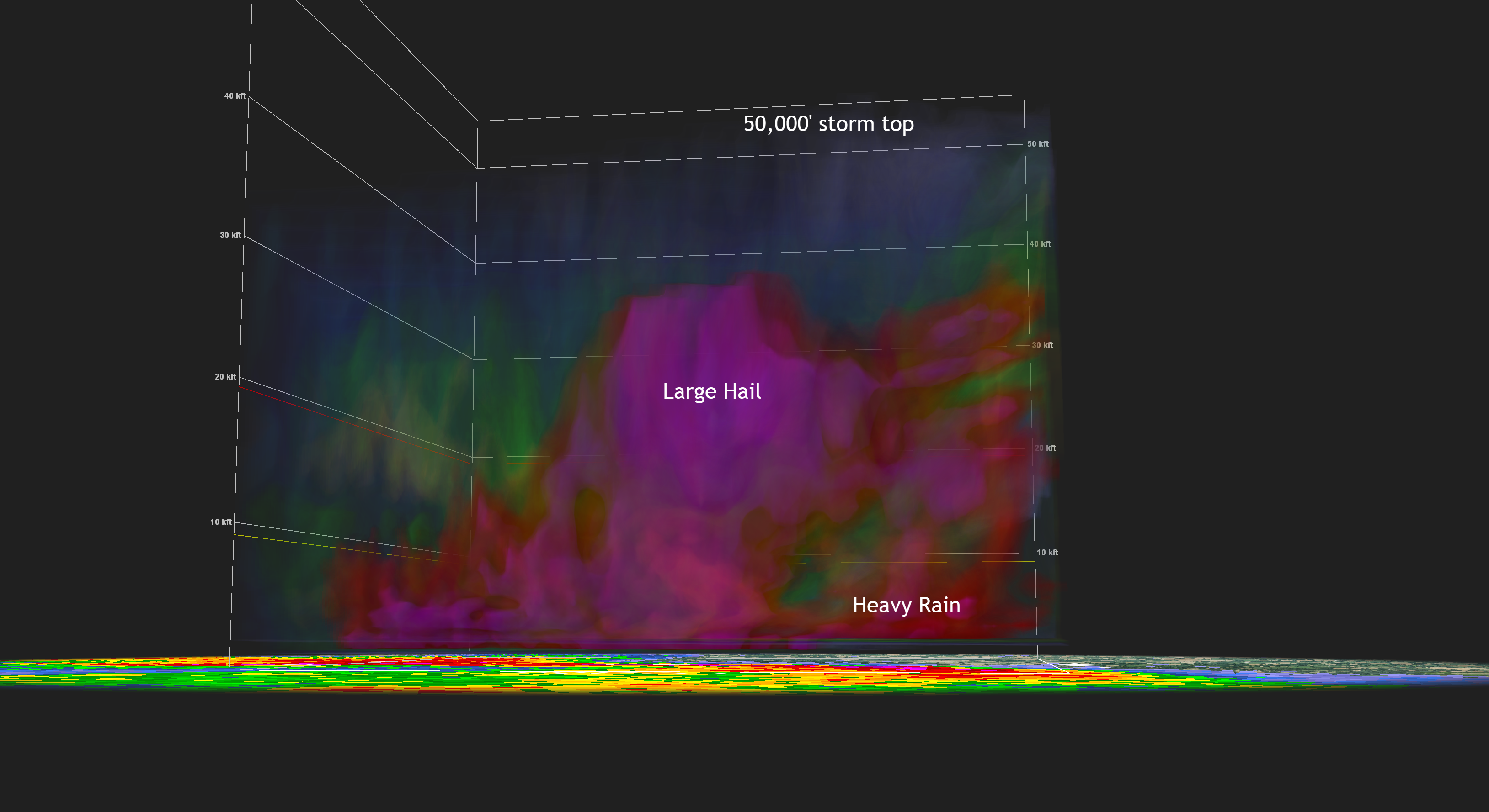
Here is a 3D view of the storm when it was producing golf ball size hail.
Here is a radar screen grab of the storm. I added some notes.
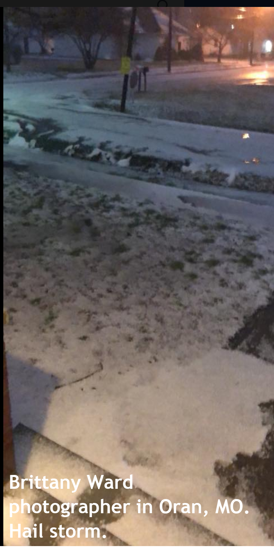
The hail accumulated 2 to 4 inches in Oran, Missouri.
You can view the radar animation and additional storm photographs by watching this video that I put together.
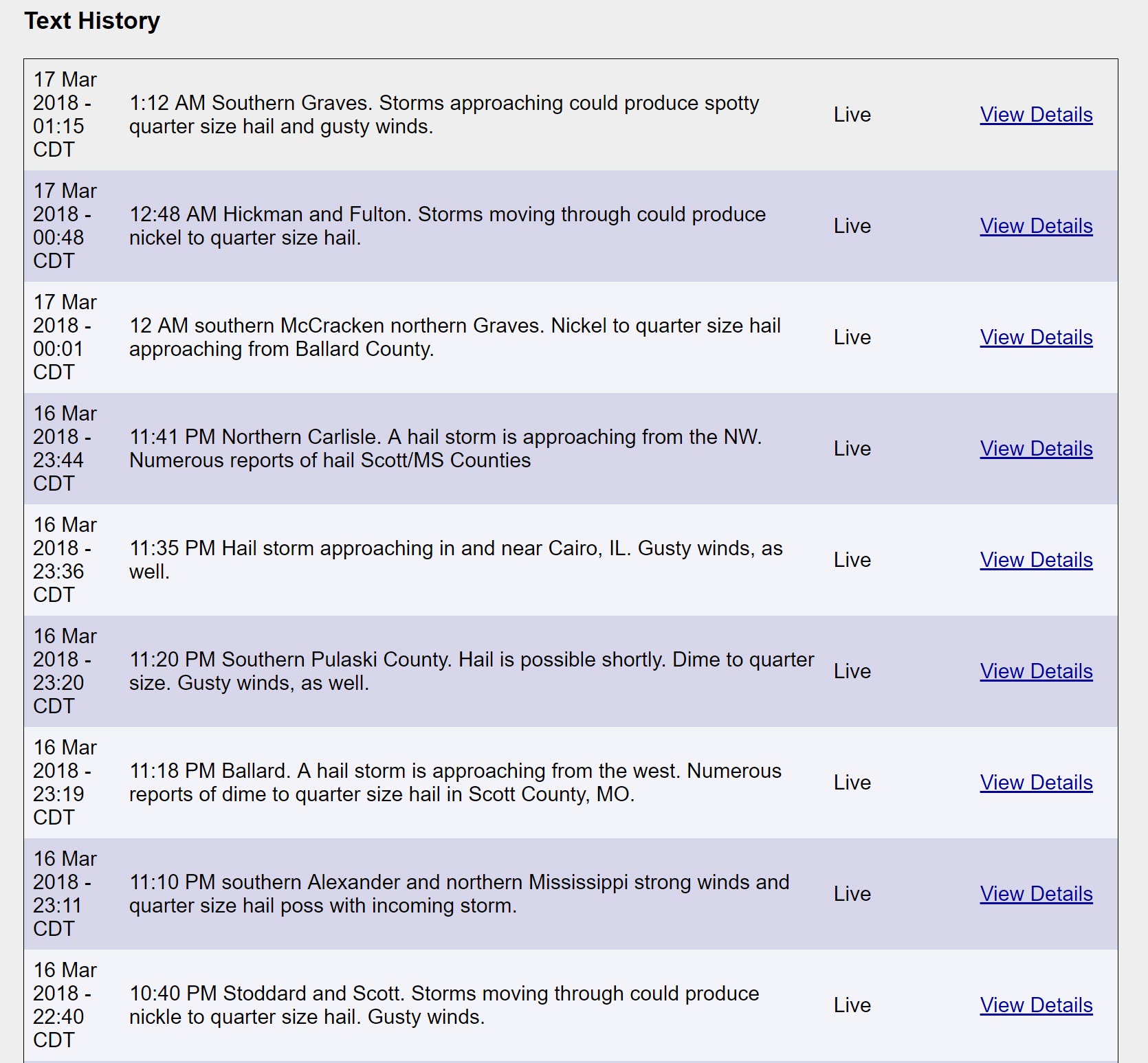
Here are some of the text messages that I sent out.
I made an error with
Marshll
County. I typed the message and apparently did not hit send. I am putting in safeguards to make sure that does not happen again.

Weather Brains is a weekly podcast/video for those who love weather and want more!
Weather Brains episode number 633
Previous episodes can be viewed by clicking here.
t’s a full house for this episode of WeatherBrains with representatives from a number of weather-related podcasts. Joining us are Becky DePodwin, Ice Station Housman, Scotty Powell from Carolina Weather Gang, Castle Williams,
WeatherHype
, Mark Jelinek, What is it About the Weather, and Phil Johnson of Storm Front Freaks Podcast. This show marks National Weather Podcast Month.
Other discussions in this weekly podcast include topics like:
- Extremes: 98 at Rio Grande Village, TX, and -7 at Cut Bank, MT
- The creative outlet that is podcasts and how they have changed over time
- The importance of providing good content in podcasting
- 25th Anniversary of Blizzard of 1993
- Astronomy Outlook with Tony Rice
- and more
.
ANNOUNCEMENT!
I am working on a few new items for us.
As always, I am grateful for all of you and the support you bring to my passion.
There was never a plan.
All of this started with a severe weather email list of ten or twenty people after the killer 2003 tornadoes. That grew to what you see today.
From that tornado, the Shadow Angel Foundation was born. We delivered hundreds of teddy bears to Pulaski, Massac, and Pope Counties. The “storm” bears went to Head Start, Kindergarten, and first graders. Included with the bears was a package of information for parents on how to talk to their child about tornadoes and severe weather.
We then worked with the Metropolis Planet on producing the Terror in the Night tornado book. The book was filled with personal accounts of that horrible night. Many people said the book helped bring closure.
Since then we have delivered thousands of teddy bears to Child Watch and Pasac. The counselors use the teddy bears to help the children feel safe.
Soon after that, the late Kent King (radio DJ and emergency manager) asked me to cover weather for McCracken County OEM/DES. I was COM 10 on the scanner feeds.
Ed Duff, with McCracken County Rescue, now utilizes my services during severe weather events along with two other local counties. They receive one on one attention during events.
That led me to Sue Henry with the American Red Cross where I was able to help during Hurricane Katrina and Rita. An experience that changed my life.
Around that time social media exploded onto the scene. My personal Facebook page quickly filled up with 5000 people. The limit Facebook allows for personal pages.
Facebook then started pages. I was able to make a page just for weather.
It was soon after that that I bought a portion of my family farm back. We built my house and the Weather Observatory.
Jason Darnall helped put together an amazing weather center. Many hours of work.
Then the Paducah Sun then asked me to do weather for them.
That led to the amazing team at Innovations Branding House. They produced my Weather Observatory website.
About four years ago there was a falling out with some local meteorologists. It bothered me so much that I almost quit weather.
The Paducah Sun even ran a story that I was taking a break from weather. I was taking a year off.
Several other local meteorologists then came to me and told me to brush it off. They encouraged me to start a weather business. They explained what I could bring to the local weather table.
Soon after that, as fate would have it, Preston Ursini and the Fire Horn team asked me to think about producing text messages during severe weather. That led to Weather Talk. That then led to the Weather Talk app.
Had it not been for that low point, I don’t think Weather Talk would have ever come to be. Life is funny like that. Something bad turned into something good.
I often times tell people that I have the best Facebook friends, enthusiasts, and followers. It is rare that someone complains on the weather page.
Some of you have basically become like family to me. When severe weather strikes it becomes personal to both you and me.
Here is what we are going to bring you.
1. We are coming out with a major app update for subscribers. We plan on having radar in the app, as well as your usual app/text messages to the daily blog, video, and Facebook updates.
2. We are completely revamping the WeatherTalk website. Preston Ursini, from The Fire Horn, is working alongside Innovations Branding House to complete this task. The Fire Horn is who I partner with to make all of this work.
3. I am going to try and stick to a daily schedule. That way everyone knows when to expect an update. See the comment section.
4. Many of you have asked me to do Facebook Live video updates during winter storms and severe weather outbreaks. I have spent the last week learning how to use OBS studio software. This software will allow me to deliver you Facebook Live events. You will get your wish.
5. We are moving towards a flat subscription fee of $5 a month. Everyone that is paying $3 a month will be grandfathered in. If you want to voluntarily upgrade to the $5 plan then that would be great. We will roll this out when the new website is finished.
Right now we have a $3, $5, and $10 plan. The only difference is how many cell phone numbers you can add.
With the $5 a month plan we will let everyone have up to seven phone numbers. That should cover your family members. Sound good?
6. I have streamlined the digital media blog. That would be the talk.weathertalk.com site. You will find that is has been organized.
Remember, I work for you. I don’t work for television or radio. I am your employee.
You have a personal meteorologist. And, as everyone knows, I put my heart and soul into this.
Subscribers will receive the following:
You may subscribe at www.beaudodsonweather.com
1. The app/text updates during tornado outbreaks and all other weather events.
2. Rapid-fire tornado app/text messages. I send out numerous updates as I track the tornado. Some of you can testify to these rapid-fire tornado messages.
3. Daily weather forecast sent to your app/text.
4. Link sent to the app/text to the daily blog and Facebook updates on non-severe weather days. Instead of waiting around for me to post a new Facebook thread you can receive it in your app/text.
5. Link sent to the app/text to the daily blog and Facebook updates on severe weather or winter storm days.
6. We are updating the weather map page on the website. That page will have thousands of daily weather maps for you to access.
7. I answer every email you send. I try to answer every private message you send to me.
8. We run three hour live feeds during severe weather where we attempt to answer as many questions as possible. Same for winter storms.
9. You receive access to special short and long-range video updates from the Bamwx team (who help me with daily videos).
10. You receive access to special short, long-range, and seasonal temperature and precipitation outlooks.
11. Your subscription fee helps six local charities (see comment section for more information).
Normal monthly out of pocket operating costs (see comment section) are around $2000.00.
The service I provide is unique. I don’t believe there is anything else like it in the country. Not for this price and not for the volume of information you receive.
We hope to have the new app and website finished soon. Watch for announcements.
New schedule
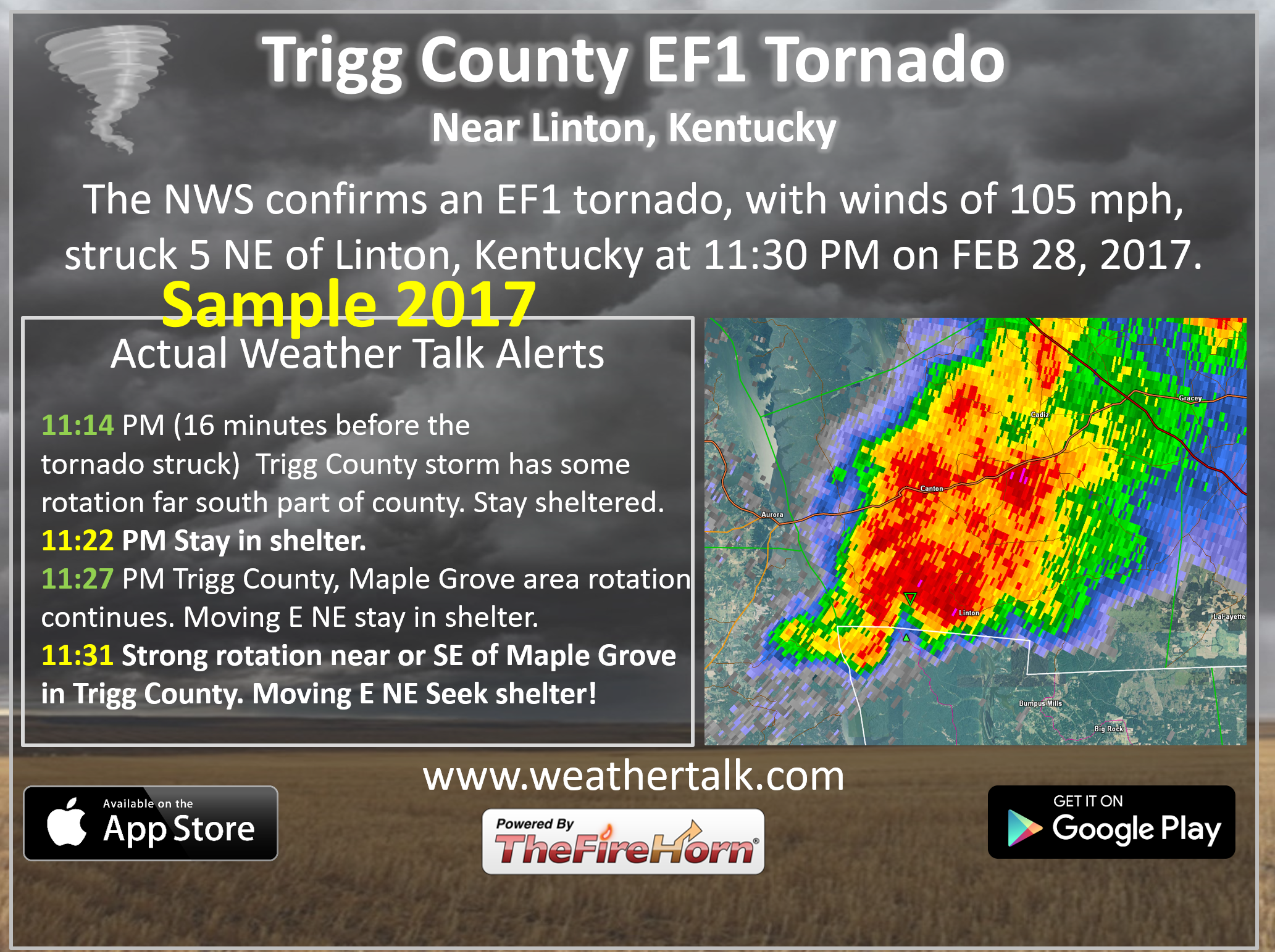
Example of some of my rapid-fire tornado app/text messages.
Make sure you have app/text notification ONE turned on. This one is called WeatherOne. You can make sure that is on by signing into your www.weathertalk.com account and clicking the personal notification settings tab. Make sure WeatherOne is on (green). Green is on. Red is off.

We offer interactive local city live radars and regional radars. If a radar does not update then try another one. If a radar does not appear to be refreshing then hit Ctrl F5. You may also try restarting your browser.
The local city view radars also have clickable warnings.
During the winter months, you can track snow and ice by clicking the winterize button on the local city view interactive radars.
You may email me at beaudodson@usawx.com
Find me on Facebook!

Find me on Twitter!

Did you know that a portion of your monthly subscription helps support local charity projects?
You can learn more about those projects by visiting the Shadow Angel Foundation website and the Beau Dodson News website.

I encourage subscribers to use the app vs regular text messaging. We have found text messaging to be delayed during severe weather. The app typically will receive the messages instantly. I recommend people have three to four methods of receiving their severe weather information.
Remember, my app and text alerts are hand typed and not computer generated. You are being given personal attention during significant weather events.
