We have some great sponsors for the Weather Talk Blog. Please support them when you have the opportunity.
Milner and Orr Funeral Home and Cremation Services located in Paducah, Kentucky and three other western Kentucky towns – at Milner and Orr they believe in families helping families. You can find Milner and Orr on Facebook, as well.
![]()

This forecast update covers far southern Illinois, far southeast Missouri, and far western Kentucky. See the coverage map on the right side of the blog.
Remember that weather evolves. Check back frequently for updates, especially during active weather.
The forecast numbers below may vary quite a bit across the region. These are averages.
Wednesday – Clouds on the increase through today with perhaps a few light showers (sleet possible) late in the day (more likely Wednesday night). Highs will mainly be in the 40’s. Well below normal temperatures. Winds will be from the northeast/east at 10 mph. My confidence in this part of the forecast verifying is high
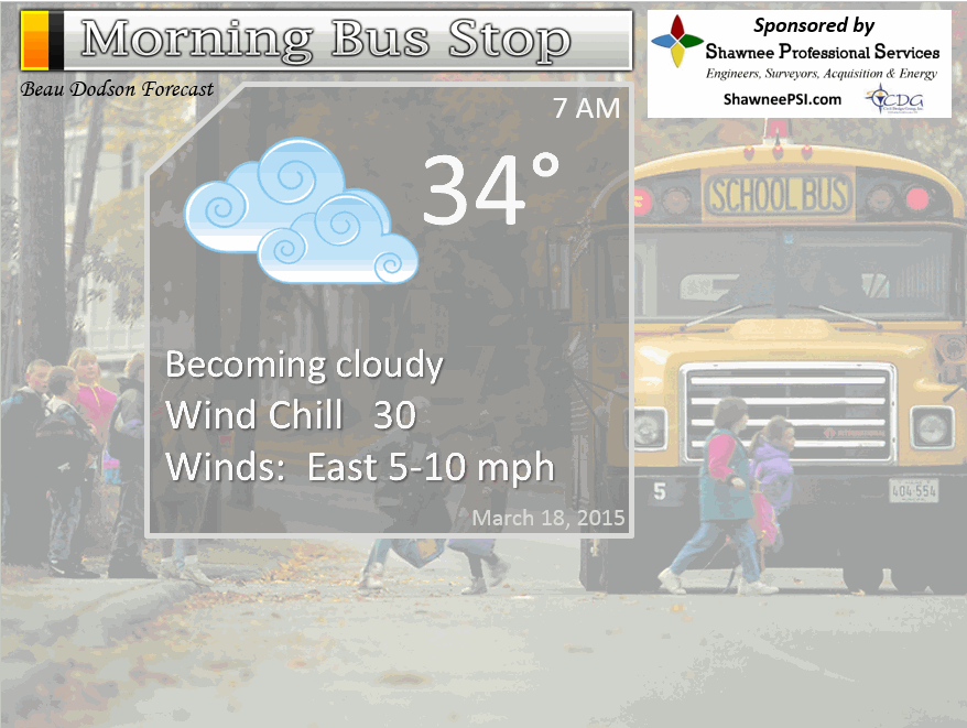
Morning School Bus Stop Weather – Chilly/coat weather. Temperatures in the 30’s! Chances of schools being delayed because of the weather = zero.
—————————————————————————————-
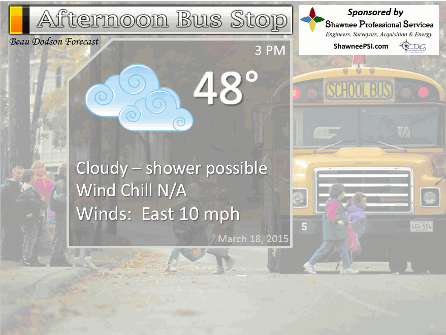
Afternoon School Bus Stop Weather – Clouds. Small chance for light showers (10% chance). Chilly with temperatures only in the 40’s for most areas and perhaps a few spots around 50 degrees.
Wednesday night – Cloudy. Chilly. Light showers. Temperatures in the upper 30’s to lower 40’s. Winds from the east/northeast at 10 mph. My confidence in this part of the forecast verifying is high
Thursday – Cloudy with a good chance for light rain showers. Chilly. Highs may not get out of the 40’s over most areas. East winds at 10 mph. My confidence in this part of the forecast verifying is high
Thursday night – Cloudy with perhaps a few lingering rain showers. Chilly. Lows in the 30’s. North winds at 10 mph. My confidence in this part of the forecast verifying is medium
Friday – Some clouds and milder. Small chance for a shower (some uncertainty on Friday’s shower chances – check back). Highs in the 50’s. Northwest winds at 10 mph. My confidence in this part of the forecast verifying is medium

The School Bus Stop Forecast is brought to your by Shawnee Professional Services. For more information click here
Current Temperatures Around The Local Area


An explanation of what is happening in the atmosphere over the coming days…
Highlights
1. Cold start for your Wednesday. Some places at or below freezing – northeast counties.
2. Rain chances increase late today into Thursday (becoming more spotty on Thursday)
3. Rainfall totals of 0.15″-0.30″
4. Saturday we briefly warm back up and then even colder air arrives (20’s back in the forecast?)
5. Light precipitation with the cold air Monday or Tuesday? See extended discussion.
Well, we said goodbye to the amazing 70’s from Monday and traded them for falling temperatures on Tuesday. Temperatures fell more than 10 degrees behind the cold front during the late morning hours over southern Illinois. The front drifted southward into Kentucky and Tennessee during the afternoon hours. Gusty winds accompanied the front. Dry. Which, I guess that was the good news!
We will have a cold start to your Wednesday morning. Temperatures will fall below freezing in some of our northeast counties. Hope you kept the coats out. Jacket weather for much of this week.
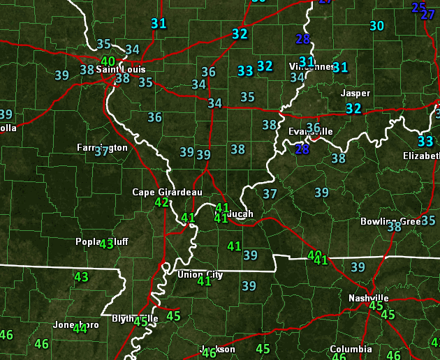
Here were the early morning temperature observations
A light rain maker will move into the region from the southwest on Wednesday afternoon and evening. We have a lot of dry air at the surface. That means virga could fall for awhile. Virga is rain or snow that falls from clouds and evaporates because of dry air at the surface. Sometimes it takes time to moisten up the entire atmospheric column. Imagine the air above you as a column.
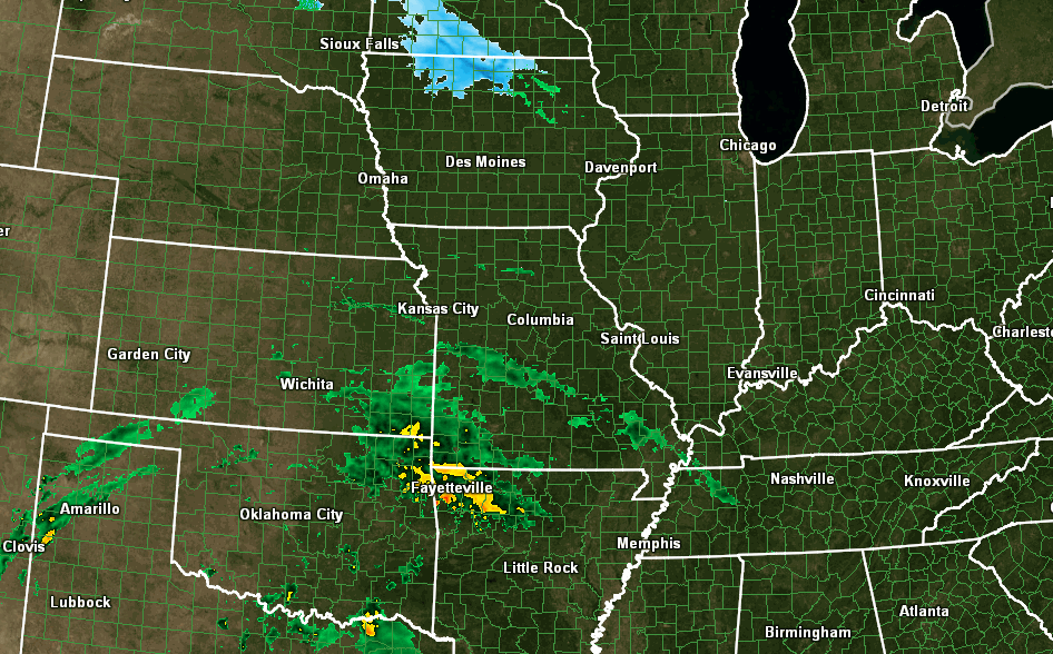
Here is the 8 am radar view – that precipitation over southeast Missouri isn’t reaching the ground. Too much dry air. Some snow up to the north in Iowa and southern Minnesota. No worries about snow here in our region.
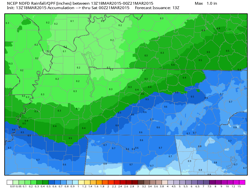
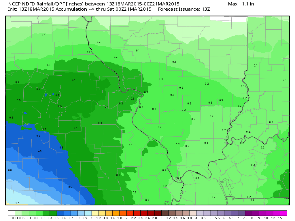
But, eventually the rain drops will make it to the ground – perhaps towards evening. More likely Wednesday night into Thursday. Right now I am thinking rainfall amounts will be light. I am forecasting 0.15″-0.25″ for most locations. Not sure we get above the 0.25″ mark.
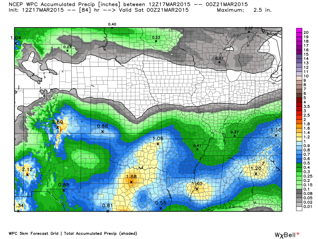
Rainfall forecast totals
Showers should become more spotty on Thursday.

We have regional radars and local city radars – if a radar does not seem to be updating then try another one. Occasional browsers need their cache cleared. You may also try restarting your browser. That usually fixes the problem. Occasionally we do have a radar go down. That is why I have duplicates. Thus, if one fails then try another one.
WEATHER RADAR PAGE – Click here —
Another weak wave moves along the front on Friday. That means some clouds and perhaps a few more showers. Some uncertainties around Friday’s rain chances. Check back for updates.
Temperatures will be well below normal on Wednesday and Thursday. Most locations will not get out of the 40’s. Chilly weather. Our cold weather is not over.
The good news is that Friday should bring a return to 50’s and Saturday might even bring some 60’s. But, don’t get used to that, either. A strong cold front arrives on Sunday with even colder air. I still think 20’s are possible in the area behind that front.
See the extended discussion below for more details.
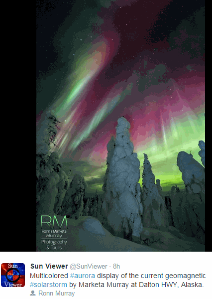
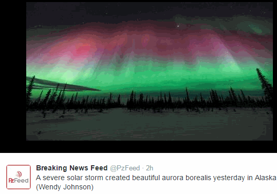
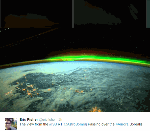
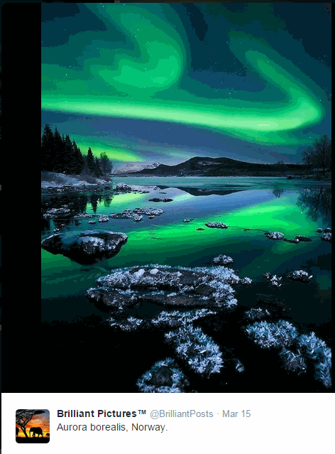
Some amazing northern lights last night. Here are some photos from social media.
Don’t forget to support our sponsors!

Updated wording on Friday’s rain chances. Updated temperatures.

Some near or below freezing readings this morning. Sensitive plants might need to be brought indoors. We may experience sub-freezing weather again later this weekend into next week. Strong cold front pushes through on Sunday. Appears even colder air arrives behind it.
Check out our sponsors! There are more on the right side bar of the page, as well. Be sure and let them know that you appreciate their sponsorship of the WeatherTalk daily weather bulletin.
How about a $5 meal deal? The DQ Grill and Chill (located across from Noble Park in Paducah, Kentucky) is the newest WeatherTalk Blog sponsor! A local business helping to sponsor the weather information that you have come to love so much.
Check out their Facebook page for specials, as well DQ Grill and Chill on Facebook


Premier Portable Buildings proudly serving our region. For more information click the above ad or here
They can also be found on this Facebook page
G&C Multi-Services out of Paducah, Kentucky. G & C Multi-Services is a service provider in Western Kentucky that provides industrial and commercial equipment fabrication, machine troubleshooting, repair and maintenance, and installation. They can custom fabricate steel, stainless, and aluminum products per customer specifications.
Visit their web-site here. Or click the ad below! Facebook page.


Wortham Dental Care located in Paducah, Kentucky. The gentle dentist. Mercury free dentistry. They also do safe Mercury removal. You can find Wortham Dental Care on Facebook, as well

Trover’s Equipment and Lawn Care – Family owned and operated! They are a dealer for Snapper, Simplicity, Snapper Pro, Bad Boy Mowers, and Intimidator Utility Vehicles. They are a Stihl and Dolmar power products dealer. They also are a dealer for Briggs & Stratton, Kohler gas & diesel engines, and Kawasaki engines. They service and repair just about any brand. You can find them on Facebook, as well
The School Bus Stop Forecast is brought to your by Shawnee Professional Services. For more information click here

Shawnee Professional Services & Civil Design Group have been providing Land Surveying, Engineering, Grant Administration and Acquisition services for the past 20 years. Currently Licensed in Illinois, Kentucky, Missouri, Indiana, and Tennessee; please contact Shawnee for any Land Surveying or Engineering needs. Shawnee’s company size allows them to devote individual attention to each client and to approach each project with the required thoroughness to successfully complete the project, large or small. Visit Shawnee’s website at shawneepsi.com for more information. Shawnee has offices in Paducah, KY, Vienna, IL and Benton, IL.

Here are the current river stage forecasts. You can click your state and then the dot for your location. It will bring up the full forecast and hydrograph.
Click Here For River Stage Forecasts…
Here are some current forecast hydrographs. These will be updated each day with new information.

Shawneetown, Illinois

Paducah, Kentucky Forecast Stage

Cairo, Illinois

The wild card tells you where the uncertainties are in the forecast
Wild card in this forecast – How much rain will fall over the coming 48 hours. I am thinking 0.15″-0.30″ for most areas. Whether we can get above that 0.30″ mark, a bit uncertain.

Can we expect severe thunderstorms over the next 24 to 48 hours? Remember that a severe thunderstorm is defined as a thunderstorm that produces 58 mph winds or higher, quarter size hail or larger, and/or a tornado.
Thunderstorm threat level is ZERO
Wednesday Severe Weather Outlook – No threats
Thursday Severe Weather Outlook – No threats
Friday Severe Weather Outlook – No threats
Saturday Severe Weather Outlook – No threats
Sunday Severe Weather Outlook – No threats


How much precipitation should we expect over the next few days?
Most areas will end up with some light rain totals. I am thinking 0.15″-0.30″. Not much, but more than we need.

Snow chances for the coming days? Zero. No risk for snow.
Jim Rasor has a new blog. Check it out when you have time http://mylocalweather.net/forum/home

This section of the blog is speculative forecast information. Because it is past the range of what meteorologists can forecast accurately, it should be considered speculation. Anything past day 5 is considered a long range forecast.
If you are looking for the pick day of the week…Saturday might be hit. We should see a brief return to warm temperatures. Thank goodness we get a nice weekend day!
A strong cold front arrives on Sunday. Much colder air behind this front. Remember that I told you we were not finished with these cold shots (and this won’t be the last one).
We may not get out of the 40’s on Sunday. Well below normal temperatures. The normal high this time of the year is around 60 degrees.
I am thinking some of our counties will dip into the 20’s by Monday morning! Keep the coats handy.
A weak weather system passes through the area on Monday and Tuesday. This could bring some light rain or snow. No accumulation expected. Flakes in the air for some? Not entirely impossible. Bottom line – cold weather isn’t finished.
Another weather system may bring precipitation into the region around Wednesday or Thursday. Too soon to know if thunderstorms will be an issue with that particular system.
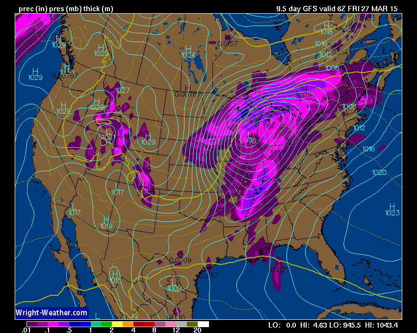
Some of the data is showing strong wind fields aloft. One ingredient for thunderstorms. Here is the 850 mb wind field forecast for next Thursday afternoon. The red colors represent some strong winds aloft.
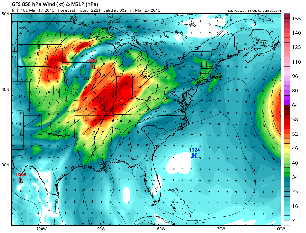
Here is the surface map per the GFS model for next Thursday. You can see a deep area of low pressure passing to our north. That would place us in the warm sector of the storm system. If this were to happen then a band of showers and locally heavy thunderstorms would accompany the front. Too far out for certainties, but I am watching the trends.
We have regional radars and local city radars – if a radar does not seem to be updating then try another one. Occasional browsers need their cache cleared. You may also try restarting your browser. That usually fixes the problem. Occasionally we do have a radar go down. That is why I have duplicates. Thus, if one fails then try another one.
If you have any problems then please send me an email beaudodson@usawx.com
WEATHER RADAR PAGE – Click here —
We also have a new national interactive radar – you can view that radar by clicking here.
Local interactive city radars include St Louis, Mt Vernon, Evansville, Poplar Bluff, Cape Girardeau, Marion, Paducah, Hopkinsville, Memphis, Nashville, Dyersburg, and all of eastern Kentucky – these are interactive radars. Local city radars – click here
NOTE: Occasionally you will see ground clutter on the radar (these are false echoes). Normally they show up close to the radar sites – including Paducah.

Regional Radar – Click on radar to take you our full radar page.


Regional Radar
![]()
Current WARNINGS (a warning means take action now). Click on your county to drill down to the latest warning information. Keep in mind that there can be a 2-3 minute delay in the updated warning information.
I strongly encourage you to use a NOAA Weather Radio or warning cell phone app for the most up to date warning information. Nothing is faster than a NOAA weather radio.


Please visit your local National Weather Service Office by clicking here. The National Weather Service Office, for our region, is located in Paducah, Kentucky. They have a lot of maps and information on their site. Local people…local forecasters who care about our region.


Here is the official 6-10 day and 8-14 day temperature and precipitation outlook. Check the date stamp at the top of each image (so you understand the time frame).
The forecast maps below are issued by the Weather Prediction Center (NOAA).


The latest 8-14 day temperature and precipitation outlook. Note the dates are at the top of the image. These maps DO NOT tell you how high or low temperatures or precipitation will be. They simply give you the probability as to whether temperatures or precipitation will be above or below normal.


Who do you trust for your weather information and who holds them accountable?
I have studied weather in our region since the late 1970’s. I have 37 years of experience in observing our regions weather patterns. My degree is in Broadcast Meteorology from Mississippi State University and an Associate of Science (AS). I am currently working on my Bachelor’s Degree in Geoscience. Just need to finish two Spanish classes!
I am a member of the American Meteorological Society. I am a NOAA Weather-Ready Nation Ambassador. And, I am the Meteorologist for McCracken County Emergency Management.
I own and operate the Southern Illinois Weather Observatory.
There is a lot of noise on the internet. A lot of weather maps are posted without explanation. Over time you should learn who to trust for your weather information.
My forecast philosophy is simple and straight forward.
- Communicate in simple terms
- To be as accurate as possible within a reasonable time frame before an event
- Interact with you on Twitter, Facebook, and the blog
- Minimize the “hype” that you might see on television or through other weather sources
- Push you towards utilizing wall-to-wall LOCAL TV coverage during severe weather events
I am a recipient of the Mark Trail Award, WPSD Six Who Make A Difference Award, Kentucky Colonel, and the Caesar J. Fiamma” Award from the American Red Cross. In 2009 I was presented with the Kentucky Office of Highway Safety Award. I was recognized by the Kentucky House of Representatives for my service to the State of Kentucky leading up to several winter storms and severe weather outbreaks.
If you click on the image below you can read the Kentucky House of Representatives Resolution.

I am also President of the Shadow Angel Foundation which serves portions of western Kentucky and southern Illinois.
Many of my graphics are from www.weatherbell.com – a great resource for weather data, model data, and more


This blog was inspired by ABC 33/40’s Alabama Weather Blog – view their blog
Current tower cam view from the Weather Observatory- Click here for all cameras.

Southern Illinois Weather Observatory

The Weather Observatory

Southern Illinois Weather Observatory
WSIL TV 3 has a number of tower cameras. Click here for their tower camera page & Illinois Road Conditions

Marion, Illinois
WPSD TV 6 has a number of tower cameras. Click here for their tower camera page & Kentucky Road Conditions & Kentucky Highway and Interstate Cameras

Downtown Paducah, Kentucky
Benton, Kentucky Tower Camera – Click here for full view

Benton, Kentucky

I24 Paducah, Kentucky

I24 Mile Point 9 – Paducah, KY

I24 – Mile Point 3 Paducah, Kentucky

You can sign up for my AWARE email by clicking here I typically send out AWARE emails before severe weather, winter storms, or other active weather situations. I do not email watches or warnings. The emails are a basic “heads up” concerning incoming weather conditions.