We have our first sponsor for the blog. Milner and Orr Funeral Home and Cremation Services located in Paducah, Kentucky and three other western Kentucky towns – at Milner and Orr they believe in families helping families. You can find Milner and Orr on Facebook, as well.
![]()

This forecast update covers far southern Illinois, far southeast Missouri, and far western Kentucky. See the coverage map on the right side of the blog.
Remember that weather evolves. Check back frequently for updates, especially during active weather.
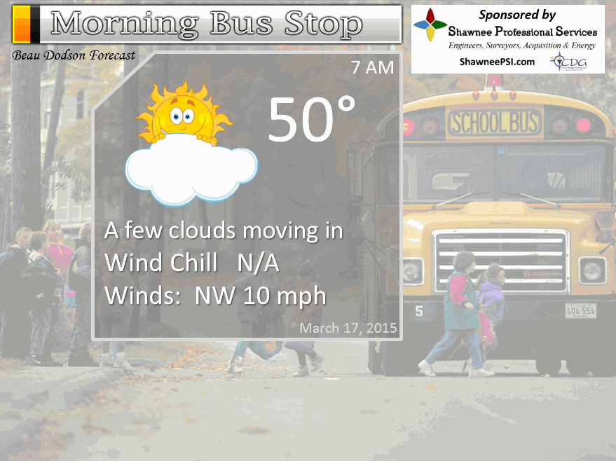
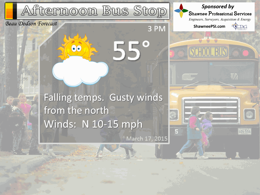
Tuesday – Some clouds and turning colder. High temperatures may occur early in the day with perhaps some lower 60’s over western KY and far southern IL, but falling into the 40’s and 50’s during the afternoon hours (from north to south). Winds becoming northwest and north at 10-20 mph and gusty. Below normal temperatures. My confidence in this part of the forecast verifying is high
Tuesday night – Increasing clouds. Colder. Lows in the 30’s. Below normal temperatures. Winds from the north/northeast at 10-15 mph. My confidence in this part of the forecast verifying is high
Wednesday – Cloudy and cold. Perhaps a few showers pushing in from the southwest and west – mostly late in the day. Highs may not get out of the 40’s over much of the area. Perhaps some 50-52 degree readings south and southwest counties. Winds becoming easterly at 5-10 mph with gusts to 15 mph. Well below normal temperatures. My confidence in this part of the forecast verifying is medium.
Wednesday night – Cloudy with some showers possible. Cool. Lows in the upper 30’s north to lower 40’s south. East winds at 10-15 mph. My confidence in this part of the forecast verifying is high
Thursday – Cloudy with some showers possible. Chilly for mid-March. High temperatures in the upper 40’s north to lower 50’s south. Winds becoming variable to northerly at 5-10 mph. Well below normal temperatures. My confidence in this part of the forecast verifying is medium.
The School Bus Stop Forecast is brought to your by Shawnee Professional Services. For more information click here

Current Temperatures Around The Local Area


An explanation of what is happening in the atmosphere over the coming days…
Hopefully you enjoyed Monday’s A M A Z I N G weather. No doubt spring fever is now in full force. Of course if you have lived in our region long enough then you know it was too good to be true.
I posted this on Facebook – I will post it here, as well
Gardeners…
We are not finished with sub-freezing temperatures. We may even have to deal with 20’s through the end of March. On and off cold shots. Each cold shot will vary in intensity. But, do not be surprised if I have to put 20’s back into the forecast.
I can’t completely promise you we won’t see snowflakes in the air…but the odds of accumulating snow become less and less with each passing day.
Ground temperatures are warm
Strong late March sun
Temperatures will always quickly warm up after a system moves through
Could it still snow over the next two weeks?
The pattern is not anti-snow. I will say that. We have quite a bit of cold weather to go. Although I can’t promise you there won’t be snow in the region, the odds of something significant are fairly low.
What is a bigger concern will be cold temperatures. I have told you over the last 2 or 3 weeks that winter is not over. By that I mean the cold temperatures.
My forecast has been for the last half of March to feature frequent cold shots. That appears to be exactly what is going to happen.
We are going to see numerous nights where temperatures drop into the 30’s and we will very likely still experience lows in the 20’s. I think the chances for teens is very low, at this point.
Not saying it won’t be warm, at times. It will be.
A roller-coaster of temperatures are forecast for the coming weeks.
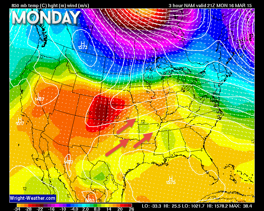
Let’s look at what is going on today (Tuesday). Cooler weather arriving. Let’s look at the upper level wind maps.
Let’s look at the 850 mb winds (winds aloft). This is the Monday map. See how the winds are from the southwest? Warm air!
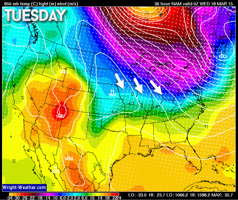
Now let’s look at Tuesday’s 850 mb wind map (winds a bit above the surface). The winds have switched and are now coming out of the north and northwest. Cooler air returns.
A strong dry cold front arrives on Tuesday and with it will arrive cooler air. Say goodbye to the 70’s and hello to the 40’s and 50’s.
The good news is that at least part of Tuesday might feel warm. That would be the morning hours and perhaps early afternoon hours. But, cooler air will already be filtering into our northern counties by mid-morning. Temperatures may actually fall over the region on Tuesday afternoon.
Some clouds will accompany the front. It will feel fallish once the front pushes through…especially if a cloud deck develops. Gusty northerly winds, as well.
How low will temperatures on on Tuesday night? Good question. Some of the high resolution data is showing lower 30’s for southern Illinois and parts of western Kentucky.
We will have to see if winds are gusty on Tuesday night. This will have an impact on temperatures. Here is the high resolution WRF model’s opinion on Wednesday morning temperatures. Either way, cold.
Not sure we go this low, but I suspect some areas will go below freezing.
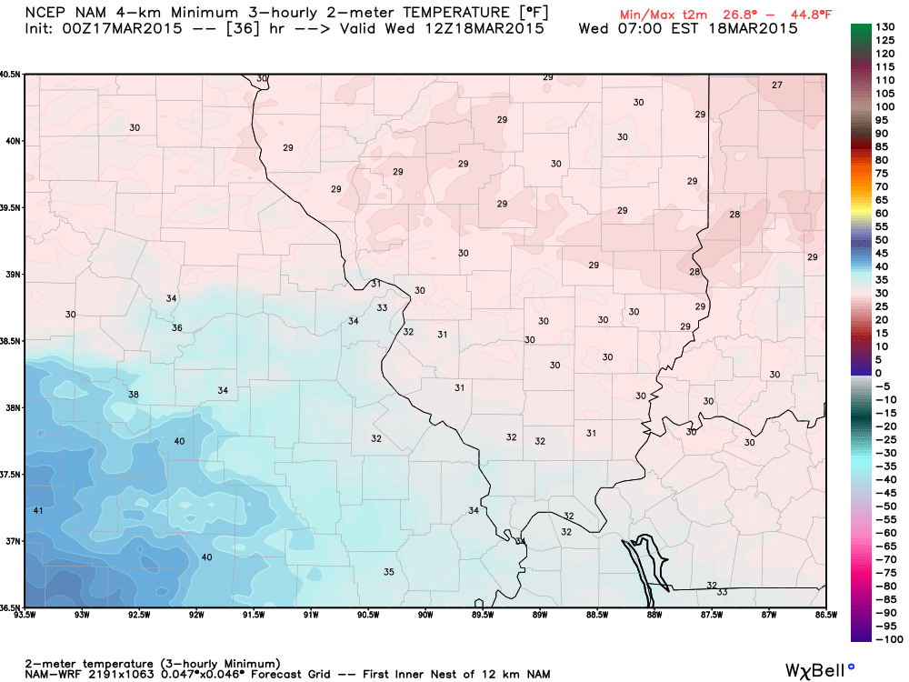
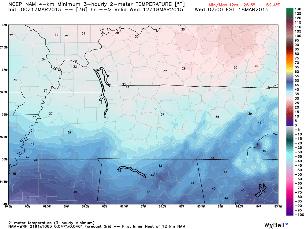
Wednesday morning lows? Let’s see if they actually do go this low. I feel confident in saying middle 30’s with some lower 30’s. Not sure how widespread the lower 30’s will be. We shall see.
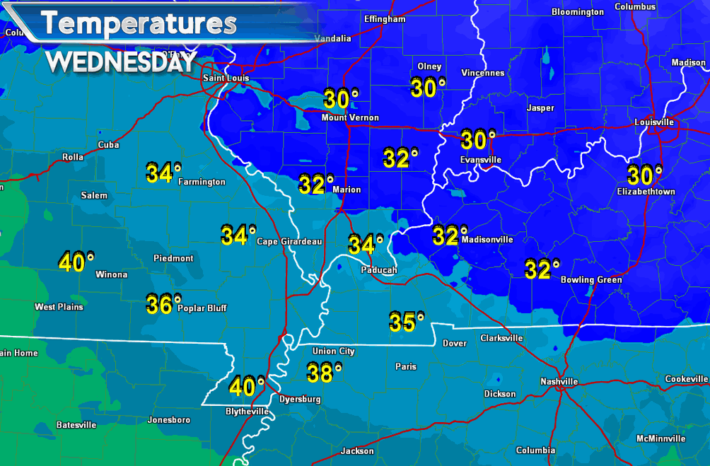
Highs on Wednesday and Thursday may not get out of the 40’s across parts of the area. Those lucky ones will struggle a few degrees above 50. Below normal temperatures overall, as expected!
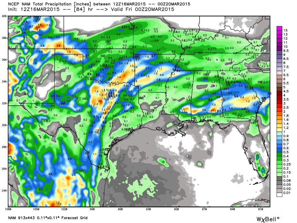
A precipitation maker will approach our region from the southwest on Wednesday into Thursday. Mixed signals on the data as to how much rain will fall. Right now it appears less than 0.25″. If the system tracks a bit further to the north then rainfall totals will have to be increased. I will continue to keep an eye on it.
Bottom line for the coming days is that it will be cooler and perhaps a little damp at times. No heavy rain is in the forecast. No severe thunderstorms, either.
See the long range discussion for details on even colder temperatures down the road.
Don’t forget to support our sponsors – see them listed below!

No major changes to the on-going forecast.
Check out our sponsors! There are more on the right side bar of the page, as well. Be sure and let them know that you appreciate their sponsorship of the WeatherTalk daily weather bulletin.
How about a $5 meal deal? The DQ Grill and Chill (located across from Noble Park in Paducah, Kentucky) is the newest WeatherTalk Blog sponsor! A local business helping to sponsor the weather information that you have come to love so much.
Check out their Facebook page for specials, as well DQ Grill and Chill on Facebook


Premier Portable Buildings proudly serving our region. For more information click the above ad or here
They can also be found on this Facebook page
G&C Multi-Services out of Paducah, Kentucky. G & C Multi-Services is a service provider in Western Kentucky that provides industrial and commercial equipment fabrication, machine troubleshooting, repair and maintenance, and installation. They can custom fabricate steel, stainless, and aluminum products per customer specifications.
Visit their web-site here. Or click the ad below! Facebook page.


Wortham Dental Care located in Paducah, Kentucky. The gentle dentist. Mercury free dentistry. They also do safe Mercury removal. You can find Wortham Dental Care on Facebook, as well

Trover’s Equipment and Lawn Care – Family owned and operated! They are a dealer for Snapper, Simplicity, Snapper Pro, Bad Boy Mowers, and Intimidator Utility Vehicles. They are a Stihl and Dolmar power products dealer. They also are a dealer for Briggs & Stratton, Kohler gas & diesel engines, and Kawasaki engines. They service and repair just about any brand. You can find them on Facebook, as well
The School Bus Stop Forecast is brought to your by Shawnee Professional Services. For more information click here

Shawnee Professional Services & Civil Design Group have been providing Land Surveying, Engineering, Grant Administration and Acquisition services for the past 20 years. Currently Licensed in Illinois, Kentucky, Missouri, Indiana, and Tennessee; please contact Shawnee for any Land Surveying or Engineering needs. Shawnee’s company size allows them to devote individual attention to each client and to approach each project with the required thoroughness to successfully complete the project, large or small. Visit Shawnee’s website at shawneepsi.com for more information. Shawnee has offices in Paducah, KY, Vienna, IL and Benton, IL.
.

Rivers remain high in the region. You can view all of the latest river stages by clicking the link below. Then pick your local river.
Notice we are starting to see the river levels fall as we push further into the coming 14 day period.
Here are the current river stage forecasts. You can click your state and then the dot for your location. It will bring up the full forecast and hydrograph.
Click Here For River Stage Forecasts…
Here are some current forecast hydrographs. These will be updated each day with new information.

Shawneetown, Illinois

Paducah, Kentucky Forecast Stage

Cairo, Illinois

The wild card tells you where the uncertainties are in the forecast
Wild card in this forecast – Temperatures on Tuesday from north to south. Colder air arrives behind a strong cold front. The front will be dry, but it will definitely usher cooler weather back into the region. Some places will likely fall into the 40’s during the afternoon hours. Warmest temperatures could be during the late morning and early afternoon hours…then temperatures could fall several degrees.

Can we expect severe thunderstorms over the next few days? Remember that a severe thunderstorm is defined as a thunderstorm that produces 58 mph winds or higher, quarter size hail or larger, and/or a tornado.
Thunderstorm threat level is – ZERO
Operation SKYWARN Severe Weather Outlook indicates no risk for severe thunderstorms for
Tuesday – No Risk
Wednesday – No Risk
Thursday – No Risk
Friday – No Risk
Saturday – No Risk
Sunday – No Risk


Will I need to take action?
If you live near rivers that are flooding then monitor the latest crest forecast levels.

How much precipitation should we expect over the next few days?
The rainfall forecast will be highly dependent on the track of the mid-week precipitation maker. If it were to shift a bit more north then rain totals might increase.
This is the NAM model’s idea of the precipitation through Thursday evening
My confidence in rainfall totals is very low. Hopefully I will have a bit more confidence in tomorrow’s update

Not anticipating any snow this week. Chilly rain possible around Wednesday evening/night.
Snow chances
Tuesday – No snow
Wednesday – No snow
Thursday – No snow
Friday – No snow
Saturday – No snow
Sunday – No snow
Watching a system next week that might interact with the cold air. Low confidence.

This section of the blog is speculative forecast information. Because it is past the range of what meteorologists can forecast accurately, it should be considered speculation. Anything past day 5 is considered a long range forecast.
One thing to keep in mind as we move forward. Although we are going to see some cold shots of air over the coming weeks, that does not mean we are heading back to some extreme cold. It will just be cold compared to averages. The averages continue to go up with each passing week. Our average high for this time of the year is now 60 degrees. If we have temperatures that are 10 degrees below normal then that still puts us near 50 degrees.
Prepare for a bit of a roller-coaster ride. It is that time of the year. The seasons are changing. As the seasons change we will see the battle of the warm air nudging northward and the cold air nudging southward. Normally that puts our region in the middle. That will certainly be the case over the coming 14 days.
We are not finished with the cold air. As I have been saying for the last several weeks…this week into next week would bring a couple (at least) of cold air shots. Not extreme, but below to well below normal temperatures. And, some data indicates additional cold shots at the very end of the month into the first part of April. Keep this in mind if you want to plant flowers/other.
This might be a situation over the coming 7 days when we see some afternoon temperatures above normal and overnight lows below normal. Sort of a roller-coaster. Many days will be below normal…across the board.
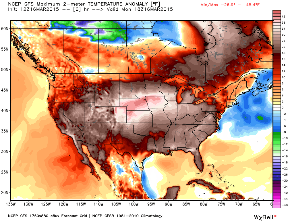
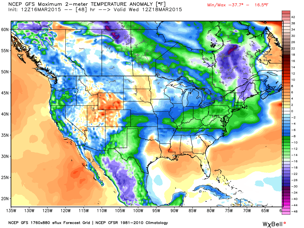
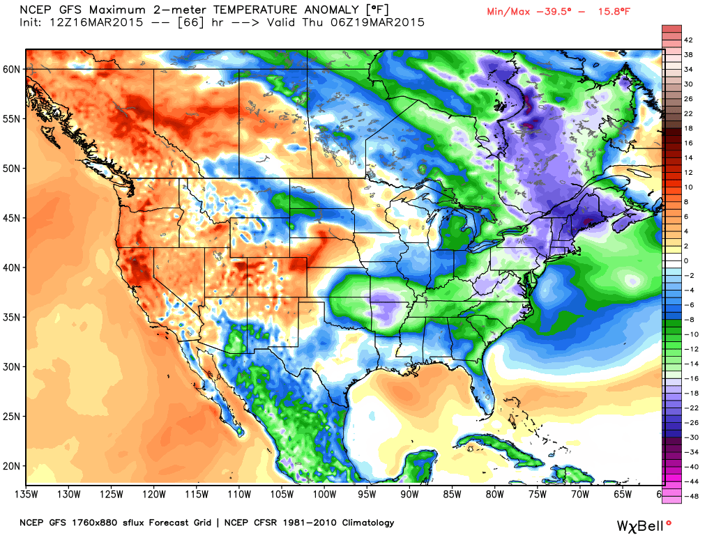
Here are the anomaly maps for the coming days (anomaly maps tell you whether temperatures will be above or below normal)
Just look at how Monday shaped up. WELL above normal temperatures in our region. No secret on that subject. I do hope you were able to enjoy the nice temperatures. I hear some people played hookey. I do not write absentee slips. Sorry, about that.
All maps can be clicked for larger view and are from weatherbell.com
Let’s step ahead into the new work week. On Wednesday morning a large chunk of the nation will have below normal temperatures.
Then on Thursday morning
Friday morning – temperatures remain below normal (scale is on the right side of the graphic)
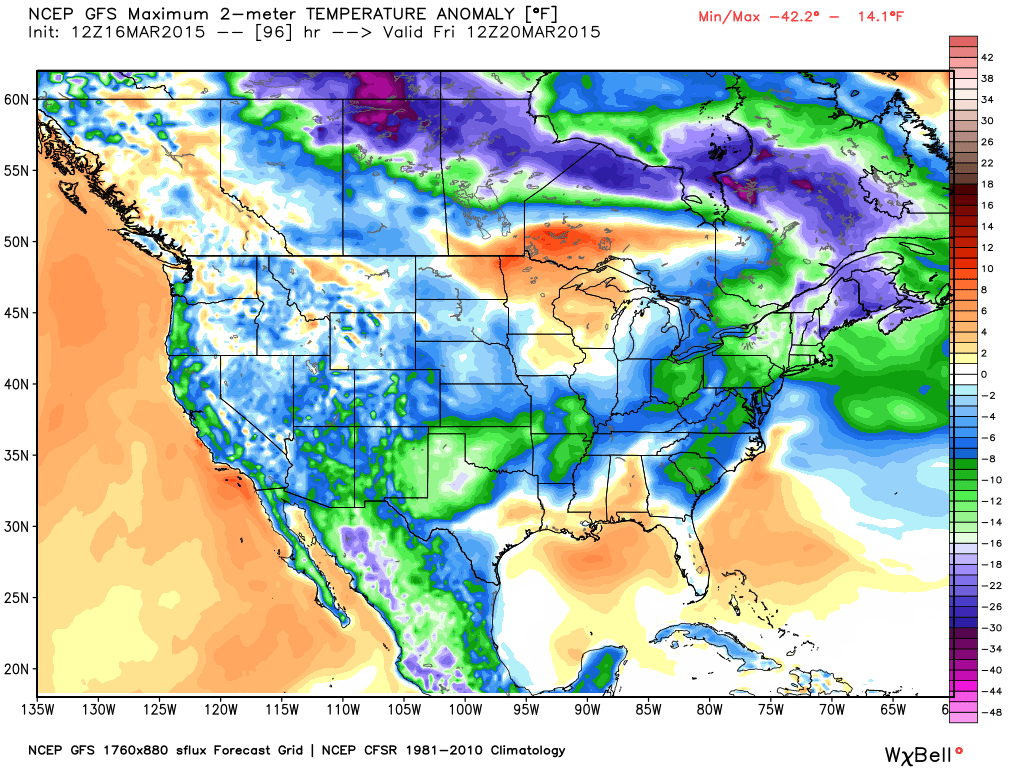
And Saturday morning. Lot of below normal temperatures in the forecast. But, that was the forecast. The forecast was for cooler temperatures this week.
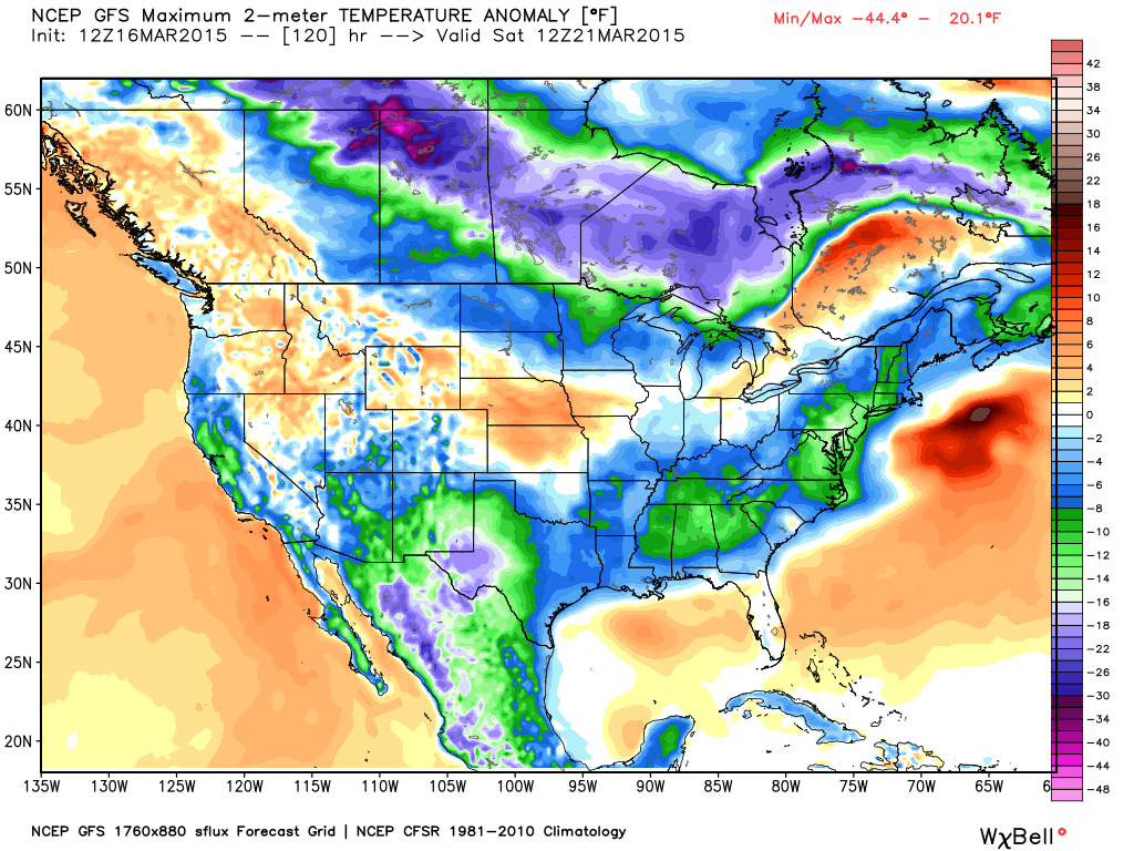
The bad news is that the charts show some of the coldest air arriving later this weekend and into part of next week. Another big cold snap towards the end of the month.
If you want to plant flowers or your garden then keep this in mind. Below normal temperatures are not finished. We aren’t finished with sub-freezing temperatures. Not yet. I promised you it would take awhile for spring to jump in full force. There will be spurts along the way, but full fledged spring may take a little longer.

We have regional radars and local city radars – if a radar does not seem to be updating then try another one. Occasional browsers need their cache cleared. You may also try restarting your browser. That usually fixes the problem. Occasionally we do have a radar go down. That is why I have duplicates. Thus, if one fails then try another one.
If you have any problems then please send me an email beaudodson@usawx.com
WEATHER RADAR PAGE – Click here —
We also have a new national interactive radar – you can view that radar by clicking here.
Local interactive city radars include St Louis, Mt Vernon, Evansville, Poplar Bluff, Cape Girardeau, Marion, Paducah, Hopkinsville, Memphis, Nashville, Dyersburg, and all of eastern Kentucky – these are interactive radars. Local city radars – click here
NOTE: Occasionally you will see ground clutter on the radar (these are false echoes). Normally they show up close to the radar sites – including Paducah.

Regional Radar – Click on radar to take you our full radar page.


Regional Radar
![]()
Current WARNINGS (a warning means take action now). Click on your county to drill down to the latest warning information. Keep in mind that there can be a 2-3 minute delay in the updated warning information.
I strongly encourage you to use a NOAA Weather Radio or warning cell phone app for the most up to date warning information. Nothing is faster than a NOAA weather radio.


Color shaded counties are under some type of watch, warning, advisory, or special weather statement. Click your county to view the latest information.

Missouri Warnings

Illinois Warnings

Kentucky Warnings

Here is the official 6-10 day and 8-14 day temperature and precipitation outlook. Check the date stamp at the top of each image (so you understand the time frame).
The forecast maps below are issued by the Weather Prediction Center (NOAA).


The latest 8-14 day temperature and precipitation outlook. Note the dates are at the top of the image. These maps DO NOT tell you how high or low temperatures or precipitation will be. They simply give you the probability as to whether temperatures or precipitation will be above or below normal.


Who do you trust for your weather information and who holds them accountable?
I have studied weather in our region since the late 1970’s. I have 37 years of experience in observing our regions weather patterns. My degree is in Broadcast Meteorology from Mississippi State University and an Associate of Science (AS). I am currently working on my Bachelor’s Degree in Geoscience. Just need to finish two Spanish classes!
I am a member of the American Meteorological Society. I am a NOAA Weather-Ready Nation Ambassador. And, I am the Meteorologist for McCracken County Emergency Management.
I own and operate the Southern Illinois Weather Observatory.
There is a lot of noise on the internet. A lot of weather maps are posted without explanation. Over time you should learn who to trust for your weather information.
My forecast philosophy is simple and straight forward.
- Communicate in simple terms
- To be as accurate as possible within a reasonable time frame before an event
- Interact with you on Twitter, Facebook, and the blog
- Minimize the “hype” that you might see on television or through other weather sources
- Push you towards utilizing wall-to-wall LOCAL TV coverage during severe weather events
I am a recipient of the Mark Trail Award, WPSD Six Who Make A Difference Award, Kentucky Colonel, and the Caesar J. Fiamma” Award from the American Red Cross. In 2009 I was presented with the Kentucky Office of Highway Safety Award. I was recognized by the Kentucky House of Representatives for my service to the State of Kentucky leading up to several winter storms and severe weather outbreaks.
If you click on the image below you can read the Kentucky House of Representatives Resolution.

I am also President of the Shadow Angel Foundation which serves portions of western Kentucky and southern Illinois.
Many of my graphics are from www.weatherbell.com – a great resource for weather data, model data, and more


This blog was inspired by ABC 33/40’s Alabama Weather Blog – view their blog
Current tower cam view from the Weather Observatory- Click here for all cameras.

Southern Illinois Weather Observatory

The Weather Observatory

Southern Illinois Weather Observatory
WSIL TV 3 has a number of tower cameras. Click here for their tower camera page & Illinois Road Conditions

Marion, Illinois
WPSD TV 6 has a number of tower cameras. Click here for their tower camera page & Kentucky Road Conditions & Kentucky Highway and Interstate Cameras

Downtown Paducah, Kentucky
Benton, Kentucky Tower Camera – Click here for full view

Benton, Kentucky

I24 Paducah, Kentucky

I24 Mile Point 9 – Paducah, KY

I24 – Mile Point 3 Paducah, Kentucky

You can sign up for my AWARE email by clicking here I typically send out AWARE emails before severe weather, winter storms, or other active weather situations. I do not email watches or warnings. The emails are a basic “heads up” concerning incoming weather conditions.