
Click one of the links below to take you directly to each section.
- Go to today’s forecast
- Go to the winter storm and severe weather outlook
- Go to the weather forecast discussion
- Go to weeks one, two, three, and four temperature and precipitation graphics
- Go to Weatherbrains
- View some of our charity work. Your subscription dollars help support these causes.
Do you have questions or suggestions? If so, please email me. Beaudodson@usawx.com
.

- Calm weather.
- Monitoring rain chances Tuesday night and Wednesday.
.

Today: No. Remember, river flooding continues. Avoid flooded roads from river flooding.
.
Tomorrow: No. Remember, river flooding continues. Avoid flooded roads from river flooding.
Sunday: No. Remember, river flooding continues. Avoid flooded roads from river flooding.
.

Confidence rating explained.
- High confidence is 70% to 100%. This means that the forecast is likely to verify.
- Medium confidence is 40% through 60%. This means that there could be adjustments in the forecast.
- Low confidence is 0% to 30%. This means that dramatic changes in the forecast are likely.
Click here if you would like to return to the top of the page

Today through Monday night.
- Is accumulating snow or ice in the forecast? No.
- Is lightning in the forecast? No
- Is severe weather in the forecast? No
* The NWS officially defines severe weather as 58 mph wind or great, 1″ hail or larger, and/or tornadoes - Is Flash flooding in the forecast? No. General river flooding will continue.

Tuesday through Friday
- Is accumulating snow or ice in the forecast? No.
- Is lightning in the forecast? No.
- Is severe weather in the forecast? No.
* The NWS officially defines severe weather as 58 mph wind or great, 1″ hail or larger, and/or tornadoes - Is flash flooding in the forecast? No. General river flooding will continue.
* The Missouri Bootheel includes Dunklin, New Madrid, and Pemiscot Counties
* Northwest Kentucky includes Daviess, Henderson, McLean Union, and Webster Counties
.
Today’s Facebook weather discussion link
Click here
Graphic-cast
Missouri


Illinois


Kentucky


Tennessee


The National Weather Service defines a severe thunderstorm as one that produces quarter size hail or larger, 58 mph winds or greater, and/or a tornado.
Today and tomorrow: No severe storms.
Monday through Friday: Severe weather is not anticipated.
.
Be sure and have WeatherOne turned on in your WeatherTalk accounts. That is the one for winter storms, ice storms, and severe weather.
Log into your www.weathertalk.com Click the personal notification settings tab. Turn on WeatherOne. Green is on. Red is off.

.

Here is the latest graphic from the WPC/NOAA.
This map shows you liquid and does not assume precipitation type. In other words, melted precipitation totals.
48-hour precipitation outlook.

Here is the seven-day precipitation forecast. This includes day one through seven.

Subscribers, do you need a forecast for an outdoor event?


Radar Link: Interactive local city-view radars & regional radars.
During winter weather be sure and click the winterize button above each city-view radar. This will show you the precipitation type.
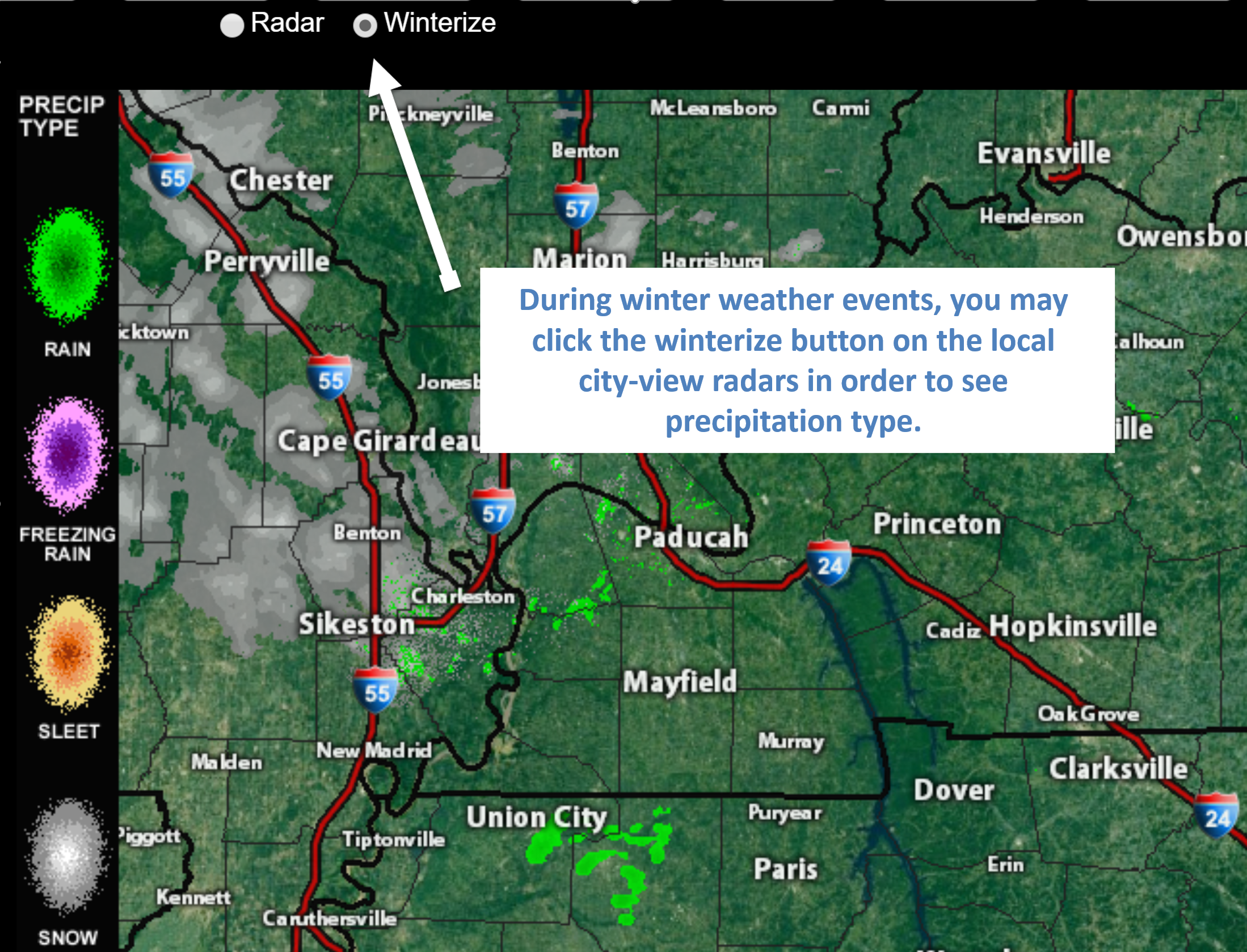
Click the image for an example of how to show winter precipitation type
You will also find clickable warning and advisory buttons on the local city-view radars.
If the radar is not updating then try another one. If a radar does not appear to be refreshing then hit Ctrl F5. You may also try restarting your browser.
Not working? Email me at beaudodson@usawx.com
National map of weather watches and warnings. Click here.
Weather Prediction Center. Click here..
.

Live lightning data: Click here.
.

Interactive GOES R satellite. Track clouds. Click here.
GOES 16 slider tool. Click here.
College of Dupage satellites. Click here
.

Here are the latest local river stage forecast numbers Click Here.
Here are the latest lake stage forecast numbers for Kentucky Lake and Lake Barkley Click Here.
..Current conditions.

These maps update several times a day. Occasionally, in between updates, you may see a duplicate day or one out of sync.
Forty-eight-hour temperature outlook.


*****
![]()

Here is the latest WPC/NOAA 6 to 10 & 8 to 14-day temperature outlooks.
.
** NOTE: These graphics are from NOAA. Our own in-house outlooks can be found below these. Sometimes forecasters disagree on the long range forecast. **
.
The cool colors indicate below normal temperatures. The darker the blue the greater the chance of below normal temperatures.
The warm colors represent the probability of above normal temperatures.
.
Days six through ten temperature outlook
Confidence % that it will be above or below normal?

Days six through ten precipitation outlook
Confidence % that it will be above or below normal?
The darker colors represent high confidence in above normal precipitation.

Days eight through fourteen temperature outlook
Confidence % that it will be above or below normal?

Days eight through fourteen precipitation outlook
Confidence % that it will be above or below normal?
The darker colors represent high confidence in above normal precipitation.

Did you know that you can find me on Twitter? Click here to view my Twitter weather account.

Not receiving app/text messages?
- Make sure you have the correct app/text options turned on. Do that under the personal notification settings tab at www.weathertalk.com. Red is off. Green is on.
- USE THE APP. Verizon and ATT have been throttling text messages. The app receives the same messages instantly. Texts can take longer. Please, use the app. It is under Beau Dodson Weather in the app stores.


Tonight’s show is the inspiration of weather enthusiast, Nashville attorney, and NashSevereWx founder David Drobny.
Tonight’s Guest WeatherBrain is Brett Kern, starting punter for the Tennessee Titans of the NFL. He just completed his 11th season and is the longest tenured Titan on the roster. Welcome to the show!
Tonight’s Guest Panelists include hosts Castle Williams and Minh Phan from the “WeatherHype” podcast. Welcome!
Other discussions in this weekly podcast include topics like:
- How does weather impact play in the NFL?
- Longest NFL game ever in September 2018 due to lightning delay (Miami)
- Ice boom breaks in Lake Erie due to late February windstorm
- New “Snow Squall Warnings” product
- The Astronomy Report from Tony Rice
- and more!
.
Previous episodes can be viewed by clicking here.
Find Beau on Facebook! Click the banner.

.
Find Beau on Twitter! Share your weather photos! @beaudodson

Click here to go to the top of the page
Did you know that a portion of your monthly subscription helps support local charity projects? Not a subscriber? Becoming one at www.weathertalk.com
You can learn more about those projects by visiting the Shadow Angel Foundation website and the Beau Dodson News website.
