We have our first sponsor for the blog. Milner and Orr Funeral Home and Cremation Services located in Paducah, Kentucky and three other western Kentucky towns – at Milner and Orr they believe in families helping families. You can find Milner and Orr on Facebook, as well.
![]()

This forecast update covers far southern Illinois, far southeast Missouri, and far western Kentucky. See the coverage map on the right side of the blog.
Remember that weather evolves. Check back frequently for updates, especially during active weather.
Sunday – A few morning clouds giving way to sunshine! Highs mostly in the 60’s. Light winds. My confidence in this part of the forecast verifying is high
Sunday night – Mostly clear and chilly. Lows in the upper 30’s to lower 40’s. Light winds. My confidence in this part of the forecast verifying is high
Monday – Spring fever alert! Mostly sunny and warm. Highs from 68 to 72 degrees. Perhaps a bit warmer in some communities. Southerly winds at 10-15 mph. My confidence in this part of the forecast verifying is high
Monday night – A few clouds and cool. Lows in the upper 40’s to lower 50’s. Light winds. My confidence in this part of the forecast verifying is high
Tuesday – Partly cloudy and turning cooler from the north in the afternoon. Highs in the 50’s over northern counties and lower 60’s southern counties. Winds becoming north late at 10 mph. My confidence in this part of the forecast verifying is medium.
Wednesday and Thursday might end up chilly. Some areas may not get out of the 40’s on Wednesday. Perhaps on Thursday we can head back into the 50’s. Northern counties could be cooler. Will keep an eye on the temp forecast. Wednesday…chilly day likely.
Rain also returns – see the long range discussion further down in the blog.

Current Temperatures Around The Local Area


An explanation of what is happening in the atmosphere over the coming days…
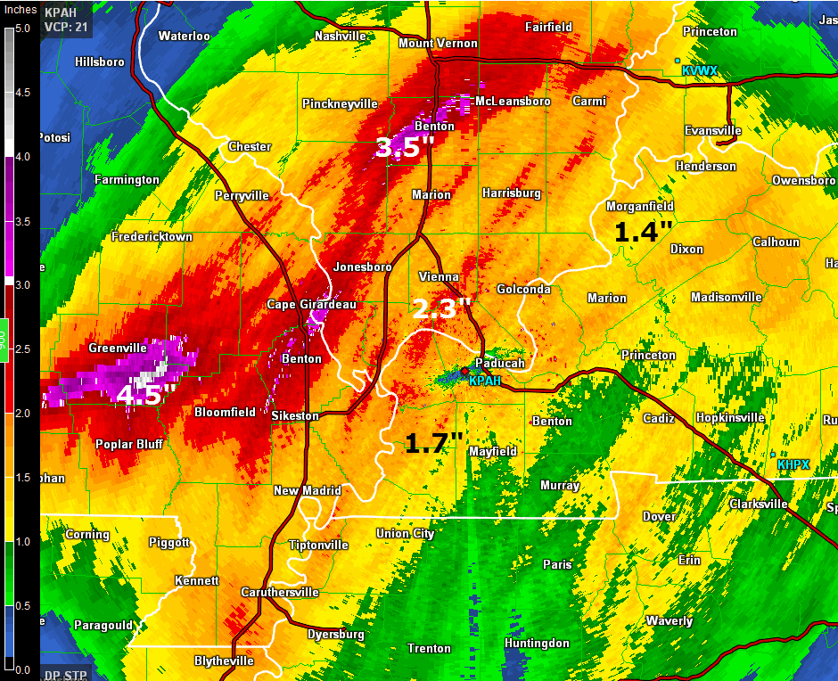
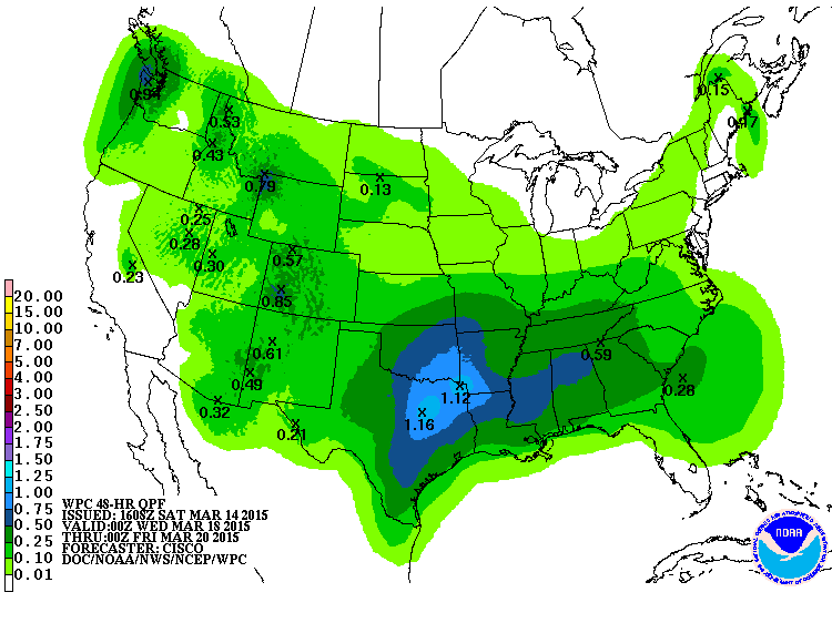
Well, did you get enough rain to last you the rest of the month? Some of you sure did. Rainfall totals exceeded 3-4 inches in parts of southeast Missouri and southern Illinois. That is enough rain to last you quite awhile.
Here are the radar estimated totals – I added a few written ones onto the map. Color scale is on the left side of the image.
Click image for a larger view
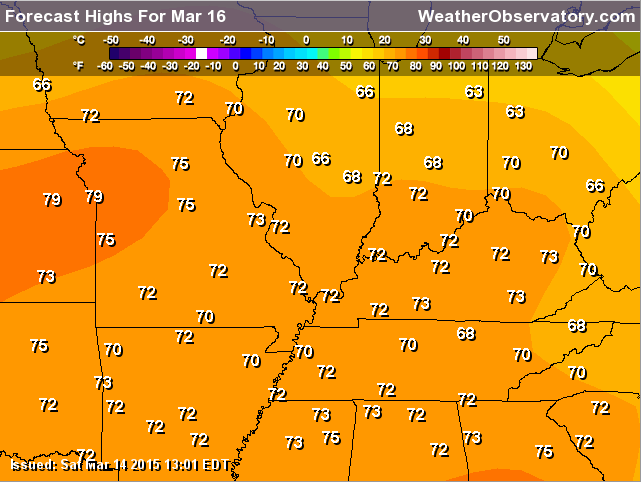
The good/great news is that today (Sunday) will be dry and tomorrow (Monday) will be dry! As a matter of fact Monday will feel more like late April! Temperatures will be in the upper 60’s to lower 70’s. Some lucky town might even reach above 74 degrees. That is the wild card in the this blog update.
Here are the official temperature forecasts for Monday – some of these temps may be a little too warm over parts of the Ohio Valley, but close. Either way, very nice temperatures! Who cares if it is 68 or 72! At this point, we will take either and with no complaining.
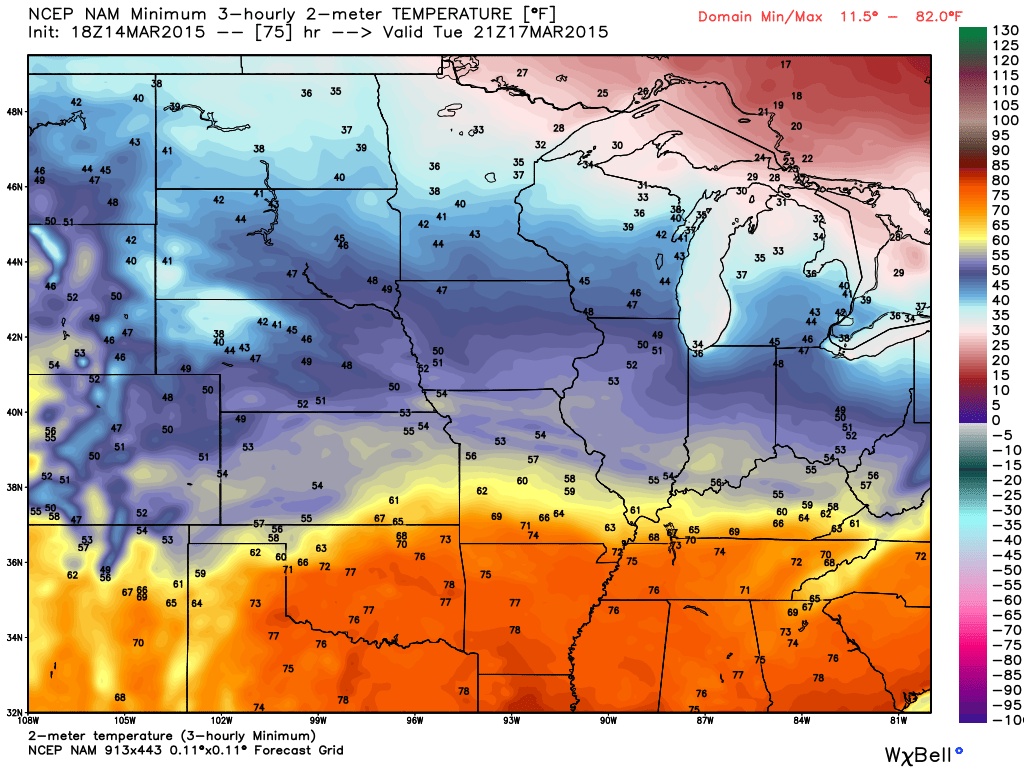
A cold front arrives Monday night into Tuesday. This front will bring cooler temperatures by the middle and end of the week (I have been talking about this cool down for about 2 weeks now). The good news is that it does not look extreme, just chilly. We might not get out of the 40’s on Wednesday and some counties may not get out of the 40’s on Thursday.
Here is what that cooler air looks like on the weather map for Tuesday – see the boundary? Fairly noticeable. Click image for a larger view. Image is from weatherbell.com
This is for 3 pm on Tuesday. You can see the orange/warm air to the south and the blue/cooler air to the north.
Another weather system will approach our region on Wednesday and Thursday – see the extended discussion for those details. More rain? Perhaps.
Don’t forget to support our sponsors – see them listed below!

No major changes since last nights update.
I have initiated daily severe weather outlook forecasts. This will continue until summer. See those below in the severe weather outlook part of the blog.
Check out our sponsors! There are more on the right side bar of the page, as well. Be sure and let them know that you appreciate their sponsorship of the WeatherTalk daily weather bulletin.
How about a $5 meal deal? The DQ Grill and Chill (located across from Noble Park in Paducah, Kentucky) is the newest WeatherTalk Blog sponsor! A local business helping to sponsor the weather information that you have come to love so much.
Check out their Facebook page for specials, as well DQ Grill and Chill on Facebook


Premier Portable Buildings proudly serving our region. For more information click the above ad or here
They can also be found on this Facebook page
G&C Multi-Services out of Paducah, Kentucky. G & C Multi-Services is a service provider in Western Kentucky that provides industrial and commercial equipment fabrication, machine troubleshooting, repair and maintenance, and installation. They can custom fabricate steel, stainless, and aluminum products per customer specifications.
Visit their web-site here. Or click the ad below! Facebook page.


Wortham Dental Care located in Paducah, Kentucky. The gentle dentist. Mercury free dentistry. They also do safe Mercury removal. You can find Wortham Dental Care on Facebook, as well

Trover’s Equipment and Lawn Care – Family owned and operated! They are a dealer for Snapper, Simplicity, Snapper Pro, Bad Boy Mowers, and Intimidator Utility Vehicles. They are a Stihl and Dolmar power products dealer. They also are a dealer for Briggs & Stratton, Kohler gas & diesel engines, and Kawasaki engines. They service and repair just about any brand. You can find them on Facebook, as well
The School Bus Stop Forecast is brought to your by Shawnee Professional Services. For more information click here

Shawnee Professional Services & Civil Design Group have been providing Land Surveying, Engineering, Grant Administration and Acquisition services for the past 20 years. Currently Licensed in Illinois, Kentucky, Missouri, Indiana, and Tennessee; please contact Shawnee for any Land Surveying or Engineering needs. Shawnee’s company size allows them to devote individual attention to each client and to approach each project with the required thoroughness to successfully complete the project, large or small. Visit Shawnee’s website at shawneepsi.com for more information. Shawnee has offices in Paducah, KY, Vienna, IL and Benton, IL.

Rivers remain high in the region. You can view all of the latest river stages by clicking the link below. Then pick your local river. Remember to avoid flood waters.
Here are the current river stage forecasts. You can click your state and then the dot for your location. It will bring up the full forecast and hydrograph.
Click Here For River Stage Forecasts…
Here are some current forecast hydrographs. These will be updated each day with new information.

Shawneetown, Illinois

Paducah, Kentucky Forecast Stage

Cairo, Illinois

The wild card tells you where the uncertainties are in the forecast
Wild card in this forecast – Temperatures on Monday. Will some of us reach 74+ degrees? A good bet will be 68 to 72 degrees. Let’s see if we can go above those numbers!

Can we expect severe thunderstorms over the next few days? Remember that a severe thunderstorm is defined as a thunderstorm that produces 58 mph winds or higher, quarter size hail or larger, and/or a tornado.
Thunderstorm threat level is – ZERO
Operation SKYWARN Severe Weather Outlook indicates no risk for severe thunderstorms for
Sunday – No Risk
Monday – No Risk
Tuesday – No Risk
Wednesday – No Risk
Thursday – No Risk
Friday – No Risk


Will I need to take action?
No serious weather issues through Tuesday.

How much precipitation should we expect over the next few days?
No rain today!
I am watching another system towards the middle of the week. Rain may creep back into the forecast around Wednesday and Thursday.
Current thoughts from NOAA on those precip totals for Wednesday and Thursday. Not totally sold on amounts, yet. Let’s keep an eye on it and update as we move forward.

Sunday – No Snow
Monday – No Snow
Tuesday – No Snow
Wednesday – No Snow
Thursday – No Snow
Jim Rasor has a new blog. Check it out when you have time http://mylocalweather.net/forum/home

This section of the blog is speculative forecast information. Because it is past the range of what meteorologists can forecast accurately, it should be considered speculation. Anything past day 5 is considered a long range forecast.
There is a lot of uncertainty in the long range forecast. This time of the year we start to see a more active jet stream. That means that models don’t handle features very well.
We are also moving more and more into the time of year where I have to watch for severe weather episodes. Not seeing anything specific, just yet. But, it won’t be much longer.
We have the potential for a semi-unsettled pattern over the next 7 days. We will be stuck between the northern jet and the southern jet.
The southern jet was responsible for all the rain over the last few weeks (and snow). The northern jet was responsible for bringing the cold air into the region, for our snow.
The southern jet is where our big precipitation makers come from.
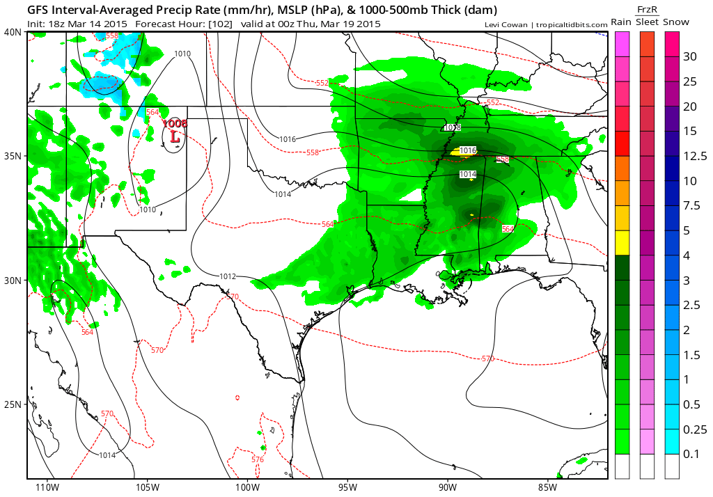
A series of precipitation makers will skirt our region over the coming 7-10 days. One of them arrives on Wednesday and Thursday. Perhaps this will bring another round of rain showers. Right now it appears the heaviest precipitation will stay to our south. But, the track will need to be monitored.
This is the GFS model. You can see the brunt of the heavier rain (dark green) is just a bit to our south. More over Tennessee and Mississippi/Alabama. Lighter green over our area.
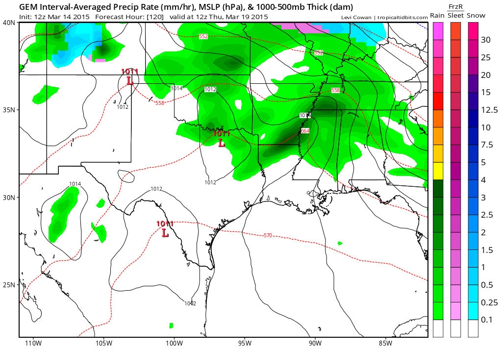
The Canadian GEM model shows rain in our region, as well. The Canadian model even has some snow to our north. Just shows you that temperatures are going to be chilly with this particular system. Had this one hit us a couple of weeks ago then it would have likely been a snow maker, as well.
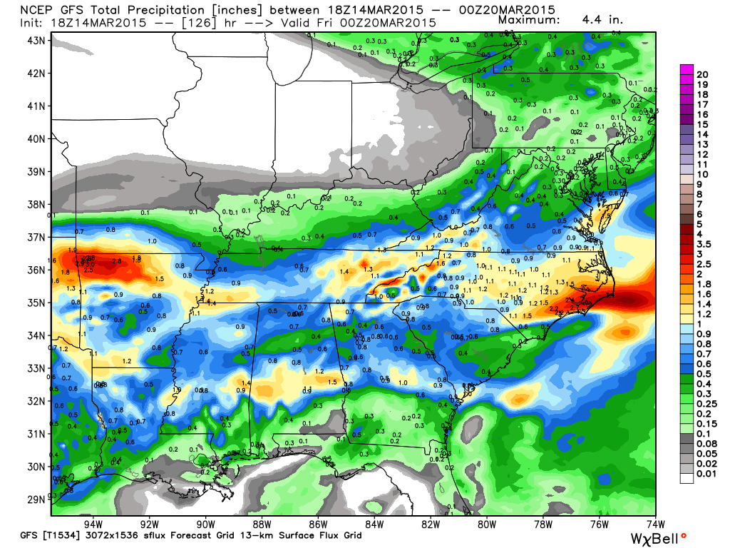
This is the total precipitation amounts from the GFS model – again, you can see a lot of the precip is to our south and southwest. Still several days out and I suspect some changes in the storm track. Monitor updates if you have anything planned for the outdoors on Wednesday into Thursday.
The good news, four our local counties, is that I do not see any snow chances. As we move further and further into March the chances of snow become less and less. A week ago I told you that I could not promise you that we were done with snow. But, as we continue to push deeper into March I am feeling better and better about the subject.
With that said, we aren’t finished with cold temperatures. We are still going below freezing over some of our counties over the coming 2 weeks. We may even have to deal with some 20’s. Right now I don’t see any teens. The deeper and deeper we go into March the less the chances for teens.
Watching the weekend for possible 20’s.
We are scaling up! It won’t be long and I will be able to stop talking about the 30’s!
Spring is coming. We have just had to be patient this year.
The signals are mixed for temperatures as we move into the weekend and early next week. Several cold shots will approach the area this week and next week. They will tease us, but perhaps be centered a bit to our north and northeast. If you remember I have been saying we were going to cool down quite a bit this week and perhaps into next week.
We will be dealing with 30’s for overnight lows some of this week and even some highs that might not get out of the 40’s. Chilly weather, but bearable.
Sunday night lows will be in the upper 30’s for some of our counties…lower 40’s elsewhere. Chilly, but not too bad.
Wednesday morning parts of southern Illinois will be in the lower 30’s. Far southern Illinois and western Kentucky will likely be in the middle 30’s. Wednesday night I am thinking 30’s and 40’s for lows.
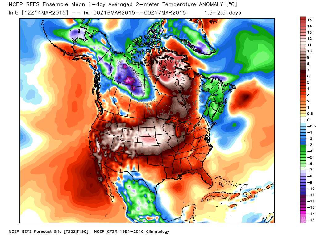
Let’s look at temperature anomalies for this week – I like to show you the over/under. How much above or below normal will temperatures be this week? Let’s start out with Sunday and Monday. Toasty? Well, not quite toasty. But, certainly above normal in the temperature department.
We can live with that news. Some amazing departures on the map – well well above normal for parts of the Northern Plains. Not too shabby in our region either. Some places may top 70 on Monday! Break out the beachwear! These two images are from weatherbell.com
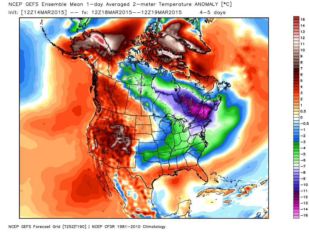
But, of course all good things must come to an end in our region. By Wednesday we will certainly be below normal in the temperature department. Some of our counties won’t even get out of the 40’s. Brrr? Well, maybe not quite brrr (not after the winter we have had)

We have regional radars and local city radars – if a radar does not seem to be updating then try another one. Occasional browsers need their cache cleared. You may also try restarting your browser. That usually fixes the problem. Occasionally we do have a radar go down. That is why I have duplicates. Thus, if one fails then try another one.
If you have any problems then please send me an email beaudodson@usawx.com
WEATHER RADAR PAGE – Click here —
We also have a new national interactive radar – you can view that radar by clicking here.
Local interactive city radars include St Louis, Mt Vernon, Evansville, Poplar Bluff, Cape Girardeau, Marion, Paducah, Hopkinsville, Memphis, Nashville, Dyersburg, and all of eastern Kentucky – these are interactive radars. Local city radars – click here
NOTE: Occasionally you will see ground clutter on the radar (these are false echoes). Normally they show up close to the radar sites – including Paducah.

Regional Radar – Click on radar to take you our full radar page.


Regional Radar
![]()
Current WARNINGS (a warning means take action now). Click on your county to drill down to the latest warning information. Keep in mind that there can be a 2-3 minute delay in the updated warning information.
I strongly encourage you to use a NOAA Weather Radio or warning cell phone app for the most up to date warning information. Nothing is faster than a NOAA weather radio.


Color shaded counties are under some type of watch, warning, advisory, or special weather statement. Click your county to view the latest information.

Missouri Warnings

Illinois Warnings

Kentucky Warnings

Here is the official 6-10 day and 8-14 day temperature and precipitation outlook. Check the date stamp at the top of each image (so you understand the time frame).
The forecast maps below are issued by the Weather Prediction Center (NOAA).


The latest 8-14 day temperature and precipitation outlook. Note the dates are at the top of the image. These maps DO NOT tell you how high or low temperatures or precipitation will be. They simply give you the probability as to whether temperatures or precipitation will be above or below normal.


Who do you trust for your weather information and who holds them accountable?
I have studied weather in our region since the late 1970’s. I have 37 years of experience in observing our regions weather patterns. My degree is in Broadcast Meteorology from Mississippi State University and an Associate of Science (AS). I am currently working on my Bachelor’s Degree in Geoscience. Just need to finish two Spanish classes!
I am a member of the American Meteorological Society. I am a NOAA Weather-Ready Nation Ambassador. And, I am the Meteorologist for McCracken County Emergency Management.
I own and operate the Southern Illinois Weather Observatory.
There is a lot of noise on the internet. A lot of weather maps are posted without explanation. Over time you should learn who to trust for your weather information.
My forecast philosophy is simple and straight forward.
- Communicate in simple terms
- To be as accurate as possible within a reasonable time frame before an event
- Interact with you on Twitter, Facebook, and the blog
- Minimize the “hype” that you might see on television or through other weather sources
- Push you towards utilizing wall-to-wall LOCAL TV coverage during severe weather events
I am a recipient of the Mark Trail Award, WPSD Six Who Make A Difference Award, Kentucky Colonel, and the Caesar J. Fiamma” Award from the American Red Cross. In 2009 I was presented with the Kentucky Office of Highway Safety Award. I was recognized by the Kentucky House of Representatives for my service to the State of Kentucky leading up to several winter storms and severe weather outbreaks.
If you click on the image below you can read the Kentucky House of Representatives Resolution.

I am also President of the Shadow Angel Foundation which serves portions of western Kentucky and southern Illinois.
Many of my graphics are from www.weatherbell.com – a great resource for weather data, model data, and more


This blog was inspired by ABC 33/40’s Alabama Weather Blog – view their blog
Current tower cam view from the Weather Observatory- Click here for all cameras.

Southern Illinois Weather Observatory

The Weather Observatory

Southern Illinois Weather Observatory
WSIL TV 3 has a number of tower cameras. Click here for their tower camera page & Illinois Road Conditions

Marion, Illinois
WPSD TV 6 has a number of tower cameras. Click here for their tower camera page & Kentucky Road Conditions & Kentucky Highway and Interstate Cameras

Downtown Paducah, Kentucky
Benton, Kentucky Tower Camera – Click here for full view

Benton, Kentucky

I24 Paducah, Kentucky

I24 Mile Point 9 – Paducah, KY

I24 – Mile Point 3 Paducah, Kentucky

You can sign up for my AWARE email by clicking here I typically send out AWARE emails before severe weather, winter storms, or other active weather situations. I do not email watches or warnings. The emails are a basic “heads up” concerning incoming weather conditions.