We have our first sponsor for the blog. Milner and Orr Funeral Home and Cremation Services located in Paducah, Kentucky and three other western Kentucky towns – at Milner and Orr they believe in families helping families. You can find Milner and Orr on Facebook, as well.
![]()

This forecast update covers far southern Illinois, far southeast Missouri, and far western Kentucky. See the coverage map on the right side of the blog.
Remember that weather evolves. Check back frequently for updates, especially during active weather.
I am working on some ideas for you subscribers. Some additional special value added content. I will have announcements as I develop all of this. Might take me a month or so. Watch for updates! Thanks to everyone who is giving and subscribing. Much appreciated.
Saturday – Rain possible during the morning…showers ending by later in the afternoon. Otherwise, quite a few clouds. Highs in the upper 50’s and lower 60’s. Northwest and north winds at 10 mph. My confidence in this part of the forecast verifying is medium
Saturday night – Partly cloudy…small chance for a few lingering showers early. Cooler. Lows in the upper 30’s to lower 40’s. North winds at 5-10 mph. My confidence in this part of the forecast verifying is high
Sunday – Some sun today, should feel springish outside. Mild. Highs in the upper 50’s to lower 60’s. North/northeast winds at 5-10 mph. My confidence in this part of the forecast verifying is high
Sunday night – Clearing. Cooler. Lows in the upper 30’s and lower 40’s. East winds winds at 5-10 mph. My confidence in this part of the forecast verifying is high
Monday – Spring fever alert! Quite a bit of sun. Spring like with highs well into the 60’s and perhaps even a few 70 degree readings. South winds at 10-15 mph. My confidence in this part of the forecast verifying is high
Current Temperatures Around The Local Area


An explanation of what is happening in the atmosphere over the coming days…
Rain rain and more rain. What a system. This system came straight out of the Gulf of Mexico. Very unusual for March. You might occasionally see something like this in late May or into June. Tropical-like.
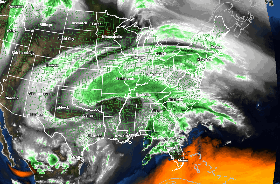
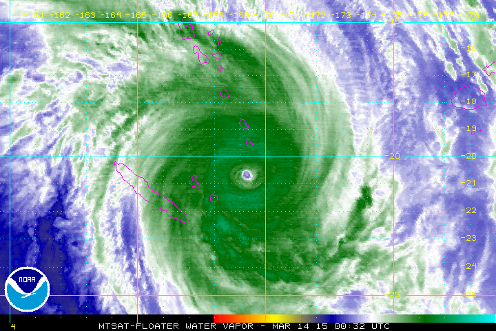
Check out this water vapor satellite image from Friday evening – a bit odd, to say the least
Showers will continue today (Saturday). The showers today won’t be as heavy as the last 24 hours. More showery in nature. I had hoped the rain would come to an end early in the day. But, the latest data does indicate rain lingering…at least scattered rain.
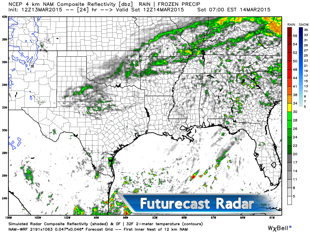
Here is the future-cast radar for Saturday. You can see some lingering rain in the area. This is around 7 am in the morning.
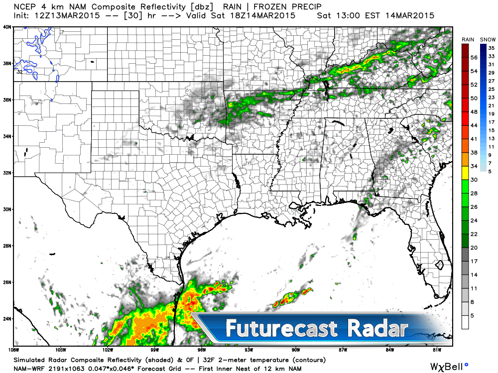
This is the noon hour – you can see a band of rain across northern Arkansas into the Missouri Bootheel and then into northern Kentucky. This is how the NAM projects the precipitation area. Bottom line, some rain may linger into Saturday.
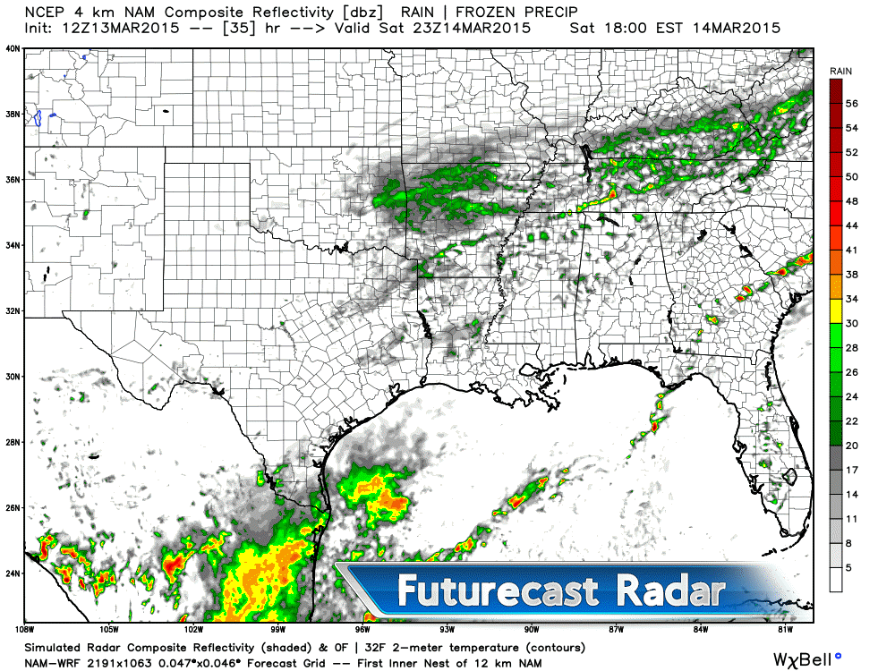
This is the 4-6 pm time frame – still some linger light precipitation in the area. Scattered in nature. A bit more over Arkansas and southern Kentucky into Tennessee vs areas to the north.

We have regional radars and local city radars – if a radar does not seem to be updating then try another one. Occasional browsers need their cache cleared. You may also try restarting your browser. That usually fixes the problem. Occasionally we do have a radar go down. That is why I have duplicates. Thus, if one fails then try another one.
WEATHER RADAR PAGE – Click here —
We also have a new national interactive radar – you can view that radar by clicking here.
Here is a screen grab of the system on Friday afternoon. Large expanse of precipitation. The milky white is cloud cover on the visible satellite image (radar overlay)
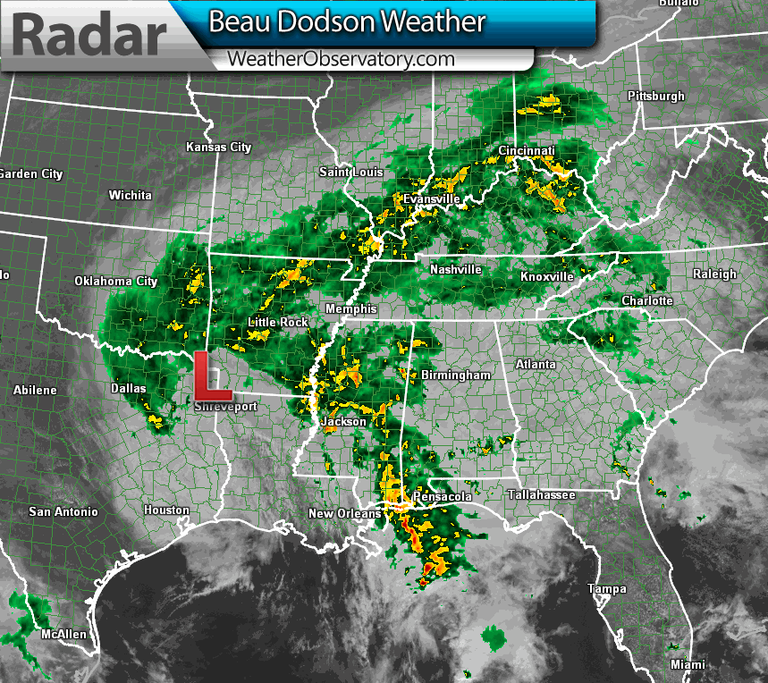
Widespread 1-3″ of rain has fallen over the region since Thursday night. Some areas have picked up more than 3″. That is a lot of rain. We did not need this rain, either. No doubt our drought has ended. Between the two large snowstorms and now the last 2 rain events. Water water water.
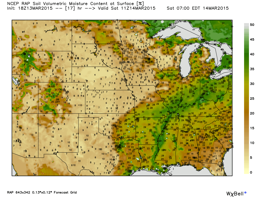
Check out the soil moisture content map – obviously we are very wet.
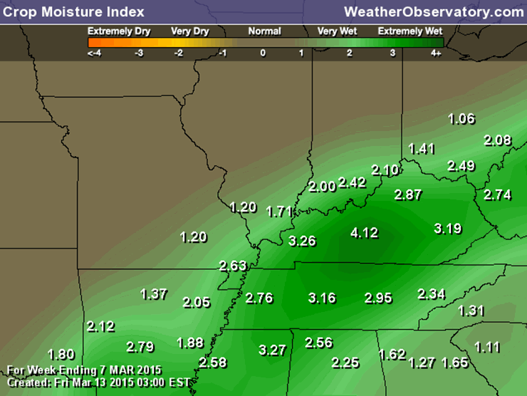
Crop Moisture Index – wet!
Rivers will continue to rise for the next few days. They should level off some next week. See the River Flood section further down in the blog. You can check your river stages via the links.
The good news is that we should dry out over the next 2-3 days. We need a break. It is spring, so don’t get to relaxed. I think we all know that spring storms are right around the corner.
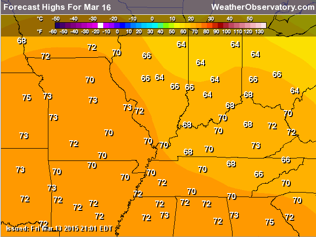
Monday might event bring some more 70 degree readings into the region. Perhaps the warmest day since last November.
Colder weather is likely over the next 2 weeks (on and off). I don’t think we are finished with 20’s just yet. Not sure about teens, but definitely not finished with lows in the 20’s. Keep that in mind. Some of you have been asking about planting gardens and the like. Hopefully after the next couple of cold shots we can move and settle into spring warmth. Patience will get us there.
Speaking of spring storms…
If you follow me on the Facebook weather page then remember that I usually run 3 hour severe weather update threads during severe weather events. They are similar to the snowstorm threads. I will answer your questions and give you frequent updates. No severe weather in the forecast for the coming days. But, just wanted to remind you of the above. I will also keep the WeatherTalk blog updated frequently during events.
Flood watches continue into early Saturday morning. Water may be slow to fall in some areas. Use care if you come across flooded roadways.

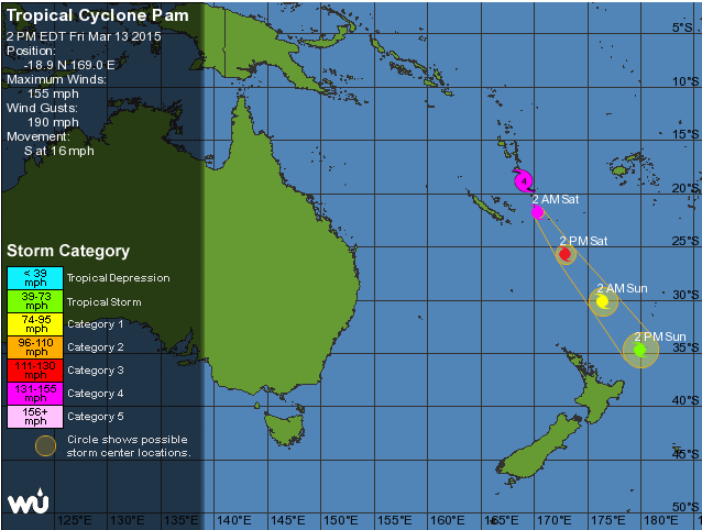
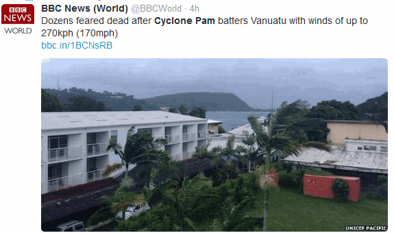
You may have heard about the intense typhoon in the Pacific. Typhoon Pam with winds over 150 mph.
Some amazing satellite images of the storm. Destructive and deadly storm.
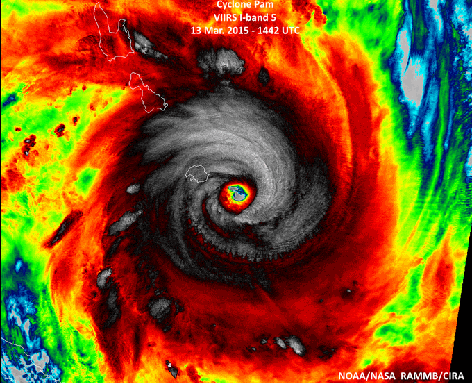
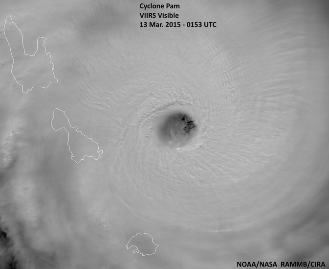
You can clearly see the eye here. Unfortunately, the eye of Typhoon Pam moved right over the island of Vanuatu. Incredible damage has been reported on the island. Fatalities are high.

Updated Monday temperatures (raised them by several degrees). I bet nobody is going to complain about that.

There could be some water over the roadways today. Keep that in mind. Water may be slow to fall in some counties. Widespread heavy rain on Thursday night into Friday night has caused creeks and streams to run high or overflow their banks. Overland flooding is an issue in some counties, as well. Just use a bit of extra care.
Several roads are closed in the region because of high water.
Check out our sponsors! There are more on the right side bar of the page, as well. Be sure and let them know that you appreciate their sponsorship of the WeatherTalk daily weather bulletin.
How about a $5 meal deal? The DQ Grill and Chill (located across from Noble Park in Paducah, Kentucky) is the newest WeatherTalk Blog sponsor! A local business helping to sponsor the weather information that you have come to love so much.
Check out their Facebook page for specials, as well DQ Grill and Chill on Facebook


Premier Portable Buildings proudly serving our region. For more information click the above ad or here
They can also be found on this Facebook page
G&C Multi-Services out of Paducah, Kentucky. G & C Multi-Services is a service provider in Western Kentucky that provides industrial and commercial equipment fabrication, machine troubleshooting, repair and maintenance, and installation. They can custom fabricate steel, stainless, and aluminum products per customer specifications.
Visit their web-site here. Or click the ad below! Facebook page.


Wortham Dental Care located in Paducah, Kentucky. The gentle dentist. Mercury free dentistry. They also do safe Mercury removal. You can find Wortham Dental Care on Facebook, as well

Trover’s Equipment and Lawn Care – Family owned and operated! They are a dealer for Snapper, Simplicity, Snapper Pro, Bad Boy Mowers, and Intimidator Utility Vehicles. They are a Stihl and Dolmar power products dealer. They also are a dealer for Briggs & Stratton, Kohler gas & diesel engines, and Kawasaki engines. They service and repair just about any brand. You can find them on Facebook, as well
The School Bus Stop Forecast is brought to your by Shawnee Professional Services. For more information click here

Shawnee Professional Services & Civil Design Group have been providing Land Surveying, Engineering, Grant Administration and Acquisition services for the past 20 years. Currently Licensed in Illinois, Kentucky, Missouri, Indiana, and Tennessee; please contact Shawnee for any Land Surveying or Engineering needs. Shawnee’s company size allows them to devote individual attention to each client and to approach each project with the required thoroughness to successfully complete the project, large or small. Visit Shawnee’s website at shawneepsi.com for more information. Shawnee has offices in Paducah, KY, Vienna, IL and Benton, IL.

Rivers will remain high for awhile. The good news is that we should dry out on Sunday into early next week. Will monitor for more precipitation towards the middle of next week, but still iffy on that occurring. I will keep an eye on it.
Some of the river crests may make it into the “major” category. NOAA has different categories for water levels. Many of you are familiar with this subject. Especially those who have to deal with river levels.
Here are the current river stage forecasts. You can click your state and then the dot for your location. It will bring up the full forecast and hydrograph.
Click Here For River Stage Forecasts…
Here are some current forecast hydrographs. These will be updated each day with new information.

Shawneetown, Illinois

Paducah, Kentucky Forecast Stage

Cairo, Illinois

Can we expect severe thunderstorms over the next 24 to 48 hours? Remember that a severe thunderstorm is defined as a thunderstorm that produces 58 mph winds or higher, quarter size hail or larger, and/or a tornado.
Thunderstorm threat level is ONE – some isolated thunderstorms are possible. No severe weather expected.


Will I need to take action?
Scattered showers for your Saturday will mean umbrella weather for some.
Those of you who live near flood prone areas will want to monitor the latest advisories and/or warnings. Some flooding will be possible into Saturday morning. This does not look like a major flash flood event, but some areas will have water issues. The ground is saturated. Additional rainfall is not welcome, but is going to happen. The good news is that we should dry out on Sunday into early next week.
Click the map for the latest watches, advisories, and warnings. You can drill down to your county.


How much precipitation should we expect over the next few days?
Saturday’s rainfall will be lighter than what happened on Thursday night into Friday evening. Saturday’s rain will be more showery in nature.
Rainfall totals on Saturday between 7 am and 7 pm should be less than 0.50″. Some areas will be quite a bit less than that.

No winter weather through the next 5 days. Colder temperatures over the coming week. Some nights could dip below freezing in some of our counties. Wednesday morning may be one of those mornings.
Jim Rasor has a new blog. Check it out when you have time http://mylocalweather.net/forum/home

This section of the blog is speculative forecast information. Because it is past the range of what meteorologists can forecast accurately, it should be considered speculation. Anything past day 5 is considered a long range forecast.
I continue to watch cold air coming down from Canada in the long range. The question is…how cold. The second question is whether the Ohio Valley might see some precipitation with the cold air. Both will need to be monitored as we move forward.
Keep checking back for updates on the upcoming pattern change.
We have regional radars and local city radars – if a radar does not seem to be updating then try another one. Occasional browsers need their cache cleared. You may also try restarting your browser. That usually fixes the problem. Occasionally we do have a radar go down. That is why I have duplicates. Thus, if one fails then try another one.
If you have any problems then please send me an email beaudodson@usawx.com
WEATHER RADAR PAGE – Click here —
We also have a new national interactive radar – you can view that radar by clicking here.
Local interactive city radars include St Louis, Mt Vernon, Evansville, Poplar Bluff, Cape Girardeau, Marion, Paducah, Hopkinsville, Memphis, Nashville, Dyersburg, and all of eastern Kentucky – these are interactive radars. Local city radars – click here
NOTE: Occasionally you will see ground clutter on the radar (these are false echoes). Normally they show up close to the radar sites – including Paducah.

Regional Radar – Click on radar to take you our full radar page.


Regional Radar
![]()
Current WARNINGS (a warning means take action now). Click on your county to drill down to the latest warning information. Keep in mind that there can be a 2-3 minute delay in the updated warning information.
I strongly encourage you to use a NOAA Weather Radio or warning cell phone app for the most up to date warning information. Nothing is faster than a NOAA weather radio.


Color shaded counties are under some type of watch, warning, advisory, or special weather statement. Click your county to view the latest information.

Missouri Warnings

Illinois Warnings

Kentucky Warnings

Please visit your local National Weather Service Office by clicking here. The National Weather Service Office, for our region, is located in Paducah, Kentucky. They have a lot of maps and information on their site. Local people…local forecasters who care about our region.


Here is the official 6-10 day and 8-14 day temperature and precipitation outlook. Check the date stamp at the top of each image (so you understand the time frame).
The forecast maps below are issued by the Weather Prediction Center (NOAA).


The latest 8-14 day temperature and precipitation outlook. Note the dates are at the top of the image. These maps DO NOT tell you how high or low temperatures or precipitation will be. They simply give you the probability as to whether temperatures or precipitation will be above or below normal.


Who do you trust for your weather information and who holds them accountable?
I have studied weather in our region since the late 1970’s. I have 37 years of experience in observing our regions weather patterns. My degree is in Broadcast Meteorology from Mississippi State University and an Associate of Science (AS). I am currently working on my Bachelor’s Degree in Geoscience. Just need to finish two Spanish classes!
I am a member of the American Meteorological Society. I am a NOAA Weather-Ready Nation Ambassador. And, I am the Meteorologist for McCracken County Emergency Management.
I own and operate the Southern Illinois Weather Observatory.
There is a lot of noise on the internet. A lot of weather maps are posted without explanation. Over time you should learn who to trust for your weather information.
My forecast philosophy is simple and straight forward.
- Communicate in simple terms
- To be as accurate as possible within a reasonable time frame before an event
- Interact with you on Twitter, Facebook, and the blog
- Minimize the “hype” that you might see on television or through other weather sources
- Push you towards utilizing wall-to-wall LOCAL TV coverage during severe weather events
I am a recipient of the Mark Trail Award, WPSD Six Who Make A Difference Award, Kentucky Colonel, and the Caesar J. Fiamma” Award from the American Red Cross. In 2009 I was presented with the Kentucky Office of Highway Safety Award. I was recognized by the Kentucky House of Representatives for my service to the State of Kentucky leading up to several winter storms and severe weather outbreaks.
If you click on the image below you can read the Kentucky House of Representatives Resolution.

I am also President of the Shadow Angel Foundation which serves portions of western Kentucky and southern Illinois.
Many of my graphics are from www.weatherbell.com – a great resource for weather data, model data, and more


This blog was inspired by ABC 33/40’s Alabama Weather Blog – view their blog
Current tower cam view from the Weather Observatory- Click here for all cameras.

Southern Illinois Weather Observatory

The Weather Observatory

Southern Illinois Weather Observatory
WSIL TV 3 has a number of tower cameras. Click here for their tower camera page & Illinois Road Conditions

Marion, Illinois
WPSD TV 6 has a number of tower cameras. Click here for their tower camera page & Kentucky Road Conditions & Kentucky Highway and Interstate Cameras

Downtown Paducah, Kentucky
Benton, Kentucky Tower Camera – Click here for full view

Benton, Kentucky

I24 Paducah, Kentucky

I24 Mile Point 9 – Paducah, KY

I24 – Mile Point 3 Paducah, Kentucky

You can sign up for my AWARE email by clicking here I typically send out AWARE emails before severe weather, winter storms, or other active weather situations. I do not email watches or warnings. The emails are a basic “heads up” concerning incoming weather conditions.