We have our first sponsor for the blog. Milner and Orr Funeral Home and Cremation Services located in Paducah, Kentucky and three other western Kentucky towns – at Milner and Orr they believe in families helping families. You can find Milner and Orr on Facebook, as well.
![]()

This forecast update covers far southern Illinois, far southeast Missouri, and far western Kentucky. See the coverage map on the right side of the blog.
Remember that weather evolves. Check back frequently for updates, especially during active weather.
I am working on some ideas for you subscribers. Some additional special value added content. I will have announcements as I develop all of this. Might take me a month or so. Watch for updates! Thanks to everyone who is giving and subscribing. Much appreciated.
Flood Watch for tonight into Saturday morning…locally heavy rain could cause streams and rivers to rise. Avoid flooded roadways.
Tonight – Rain developing. Thunder possible. Lows in the 50’s. Light winds.
Friday – Cloudy with rain likely, maybe a rumble of thunder. Moderate to heavy rain possible. Highs in the upper 50’s to lower 60’s. East winds at 10 mph becoming southerly at 10-15 mph. My confidence in this part of the forecast verifying is high
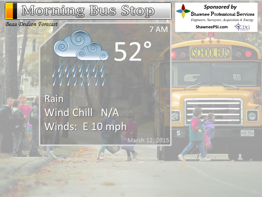
Morning School Bus Stop Weather – Rain likely. Maybe a rumble of thunder. Morning temperatures in the 50’s. Chances of schools being delayed because of the weather zero.
—————————————————————————————-
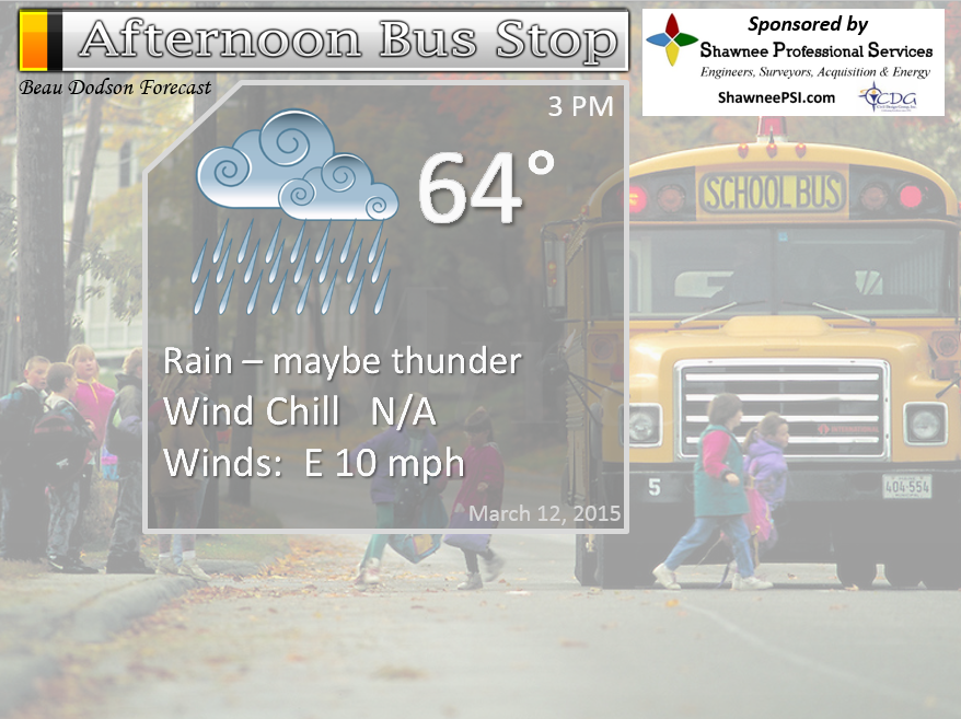
Afternoon School Bus Stop Weather – Chance for rain, maybe a rumble of thunder. Temperatures around 60 degrees.
Friday night – Cloudy with some rain in the area. Highs in the upper 50’s to middle 60’s. Southwest winds turning west at 5-10 mph. My confidence in this part of the forecast verifying is high
Saturday – Rain possible during the morning…showers ending by later in the afternoon. Otherwise, quite a few clouds. Highs in the upper 50’s and lower 60’s. Northwest and north winds at 10 mph. My confidence in this part of the forecast verifying is medium
Saturday night – Partly cloudy. Cooler. Lows in the 40’s. North winds at 5-10 mph. My confidence in this part of the forecast verifying is high
Sunday – Some sun today, should feel springish outside. Mild. Highs in the upper 50’s to lower 60’s. North winds at 5-10 mph. My confidence in this part of the forecast verifying is high

The School Bus Stop Forecast is brought to your by Shawnee Professional Services. For more information click here
Current Temperatures Around The Local Area


An explanation of what is happening in the atmosphere over the coming days…
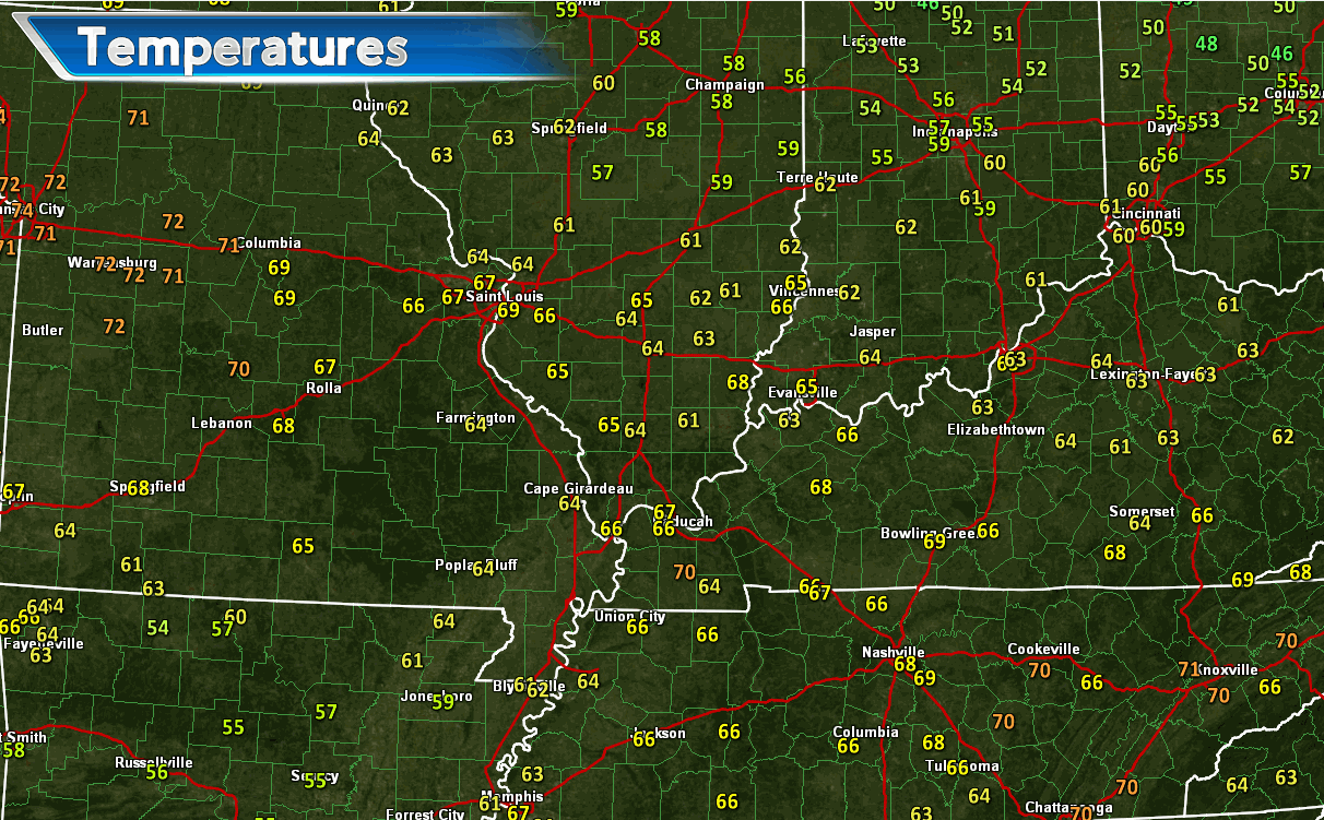
Who enjoyed today’s weather? I promised you spring like conditions. Paducah, Kentucky hit 70 degrees. This was the first time Paducah has hit 70 since last November. Got to love that!
Temperatures on Thursday afternoon. A screen grab of some of those mild temperatures.
Our well advertised precipitation maker has arrived and with it comes abundant moisture.
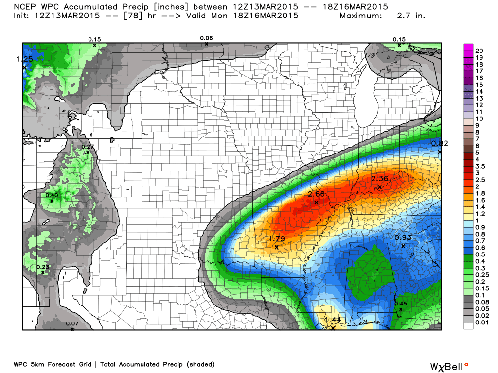
Widespread rain and some thunderstorms will be the rule across the area into Friday night. Widespread 1-3″ rainfall totals will likely occur with this event. The heaviest band may be along or north of the Ohio River. Some places will likely have some water issues. Creeks are high, streams are high, rivers are high, the ground is saturated, and some areas are already having standing water problems.
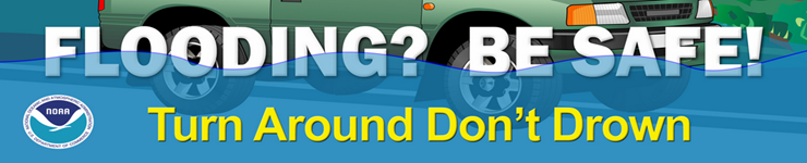
Flood watches blanket the area. Avoid flooded roadways.
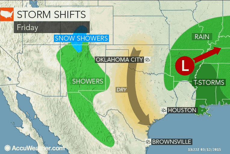
Rain will linger into Saturday. At one time it appears the rain might end by Saturday morning. New data lingers rain in the region for a longer period of time.
Sunday will be dry! Some good news. Sunday should also bring more 50’s and 60’s for high temperatures. The March sun is going to feel great. Are we getting used to the time change, yet? Meteorologists don’t like the time change…all that much. It means we have to wait longer for the latest model data.
Here are the latest watches and warnings – click the map to drill down to your local county


We have regional radars and local city radars – if a radar does not seem to be updating then try another one. Occasional browsers need their cache cleared. You may also try restarting your browser. That usually fixes the problem. Occasionally we do have a radar go down. That is why I have duplicates. Thus, if one fails then try another one.
WEATHER RADAR PAGE – Click here —
We also have a new national interactive radar – you can view that radar by clicking here.
Local interactive city radars include St Louis, Mt Vernon, Evansville, Poplar Bluff, Cape Girardeau, Marion, Paducah, Hopkinsville, Memphis, Nashville, Dyersburg, and all of eastern Kentucky – these are interactive radars. Local city radars – click here
NOTE: Occasionally you will see ground clutter on the radar (these are false echoes). Normally they show up close to the radar sites – including Paducah.


Live Lightning Data – zoom and pan: Click here
Live Lightning Data with sound (click the sound button on the left side of the page): Click here
I am watching interesting weather as we push into late next week and the following. Still a lot of questions as to how the overall pattern evolves. I will discuss that subject in the long range section of the blog.
Nice photograph from the Wunderground web-site
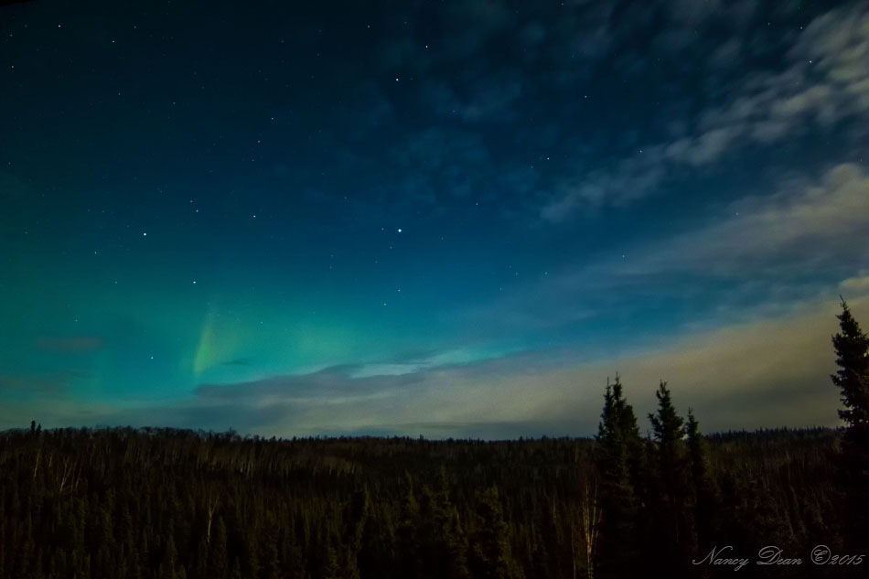
Soldotna, Alaska
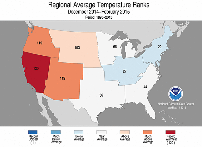
My winter forecast for the Ohio Valley was for colder than normal and drier than normal for the December through February time period. NOAA has released their official rankings. These rankings are from 1895 to 2015. You can see the Ohio Valley was colder than normal. We ranked 27th coldest since 1895.
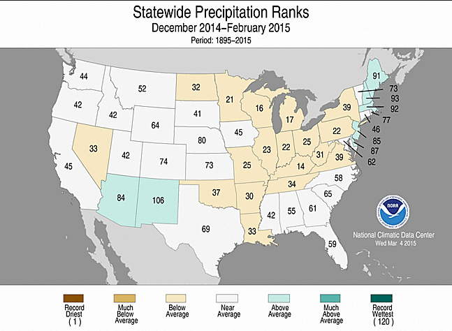
And here is the precipitation numbers. The Ohio Valley was on the dry side. Kentucky was the 14th driest since 1895. We did end on a high note with the snow event in February. Not enough to change the rankings overall.
Don’t forget that I am trying to get people to sign up for a small monthly donation. A lot of people are giving between $2-$5. If I can build this base larger then it will help cover my costs and the time I put into all of this. I do not work for a TV or radio station.
The subscribe button.

Updated temperatures. No real changes in this update to the ongoing forecast. Lot of rain.

Flooding. Areas that pick up the heaviest rain will likely see additional rises in creeks and rivers. Overland flooding will also be an issue. Flood prone areas will see water problems.
Large rivers continue to rise, as well. I have posted some flood links further down in the blog. Be sure and check those out.
Check out our sponsors! There are more on the right side bar of the page, as well. Be sure and let them know that you appreciate their sponsorship of the WeatherTalk daily weather bulletin.
How about a $5 meal deal? The DQ Grill and Chill (located across from Noble Park in Paducah, Kentucky) is the newest WeatherTalk Blog sponsor! A local business helping to sponsor the weather information that you have come to love so much.
Check out their Facebook page for specials, as well DQ Grill and Chill on Facebook


Premier Portable Buildings proudly serving our region. For more information click the above ad or here
They can also be found on this Facebook page
G&C Multi-Services out of Paducah, Kentucky. G & C Multi-Services is a service provider in Western Kentucky that provides industrial and commercial equipment fabrication, machine troubleshooting, repair and maintenance, and installation. They can custom fabricate steel, stainless, and aluminum products per customer specifications.
Visit their web-site here. Or click the ad below! Facebook page.


Wortham Dental Care located in Paducah, Kentucky. The gentle dentist. Mercury free dentistry. They also do safe Mercury removal. You can find Wortham Dental Care on Facebook, as well

Trover’s Equipment and Lawn Care – Family owned and operated! They are a dealer for Snapper, Simplicity, Snapper Pro, Bad Boy Mowers, and Intimidator Utility Vehicles. They are a Stihl and Dolmar power products dealer. They also are a dealer for Briggs & Stratton, Kohler gas & diesel engines, and Kawasaki engines. They service and repair just about any brand. You can find them on Facebook, as well
The School Bus Stop Forecast is brought to your by Shawnee Professional Services. For more information click here

Shawnee Professional Services & Civil Design Group have been providing Land Surveying, Engineering, Grant Administration and Acquisition services for the past 20 years. Currently Licensed in Illinois, Kentucky, Missouri, Indiana, and Tennessee; please contact Shawnee for any Land Surveying or Engineering needs. Shawnee’s company size allows them to devote individual attention to each client and to approach each project with the required thoroughness to successfully complete the project, large or small. Visit Shawnee’s website at shawneepsi.com for more information. Shawnee has offices in Paducah, KY, Vienna, IL and Benton, IL.

Rivers continue to rise. Don’t expect them to fall off anytime soon, either. This new rain event will likely cause some additional rises or at the very least prolong the event. This does not look to be a severe flood (nothing like 2011). This is more of a moderate river flood event. Those areas that have problems during a typical spring flood will have issues.
Some of the river crests may make it into the “major” category. NOAA has different categories for water levels. Many of you are familiar with this subject. Especially those who have to deal with river levels.
Here are the current river stage forecasts. You can click your state and then the dot for your location. It will bring up the full forecast and hydrograph.
Click Here For River Stage Forecasts…
Here are some current forecast hydrographs. These will be updated each day with new information.

Shawneetown, Illinois

Paducah, Kentucky Forecast Stage

Cairo, Illinois

The wild card tells you where the uncertainties are in the forecast
Wild card in this forecast – the wild card for the next 24 hours will be whether we hear some rumbles of thunder with this rain event. Appears possible. Not expecting severe thunderstorms…some good news in the mix.

Can we expect severe thunderstorms over the next 24 to 48 hours? Remember that a severe thunderstorm is defined as a thunderstorm that produces 58 mph winds or higher, quarter size hail or larger, and/or a tornado.
Thunderstorm threat level is ONE – some thunderstorms are possible. No severe weather expected.


Will I need to take action?
Umbrella weather has arrived (did it ever leave).
Those of you who live near flood prone areas will want to monitor the latest advisories and/or warnings. Some flooding will be possible into Saturday morning. This does not look like a major flash flood event, but some areas will have water issues. The ground is saturated. Additional rainfall is not welcome, but is going to happen. The good news is that we should dry out on Sunday into early next week.

How much precipitation should we expect over the next few days?
Click image for full size view – image is from weatherbell.com

No winter weather through the next 5 days. Watching late next week into the following week for colder temperatures. We will have to wait and see if there is any precipitation during that time period. We may see a strong warm-up before the cold weather arrives, as well.
Jim Rasor has a new blog. Check it out when you have time http://mylocalweather.net/forum/home

This section of the blog is speculative forecast information. Because it is past the range of what meteorologists can forecast accurately, it should be considered speculation. Anything past day 5 is considered a long range forecast.
My focus on the long range continues to center around what I would consider an interesting pattern setting up towards the middle and end of next week and lasting into the following week.
There is a lot of cold air forecast to move southward from Canada next week into next weekend/following week. But, the placement of that cold air and its movement is still in question. Will the center/core of this cold air be more to our northeast? Or, will it be placed over our region and the Missouri Valley?
The cold air will make a dive southward towards the middle and end of next week. There may be a couple of pushes of cold air. There could also be a strong boundary setting up somewhere in the central United States. This boundary would then be the focus for a possible storm system to develop.
By boundary I mean a temperature boundary. Cold air to the north and warm air to the south. Sharp boundary, perhaps.
All of this peaks my interest. Typically if a strong boundary develops then active weather soon follows. Will there be one or two areas of low pressure move along the boundary? Will that mean a lot of warm air in our region followed by the cold blast? If so, how cold will it be?
I definitely don’t think we are finished with overnight lows in the 20’s. Whether we see teens again before spring finally settles in…that will need to be monitored.
Another concern with a strong boundary is the potential for thunderstorms and heavy rain. The concern to the north of the boundary would be winter precipitation.
We should remain mostly dry Sunday into Tuesday. I will need to monitor the pattern beyond that time frame.
I am on board for a several more cold shots before spring arrives or at least settles into the region.
Next week and the following week will need to be monitored. Active weather is possible if that boundary develops.
We are moving towards the time of year when we experience more and more severe weather concerns. Of course in our region there is no such thing as a severe weather season. We can experience severe thunderstorms and tornadoes year round. But, typically as we move into late March and April we will see an uptick in severe thunderstorms.
I will continue to monitor the potential cold air and the potential for a strong boundary to form somewhere in the central U.S. next week and the week after.
We have regional radars and local city radars – if a radar does not seem to be updating then try another one. Occasional browsers need their cache cleared. You may also try restarting your browser. That usually fixes the problem. Occasionally we do have a radar go down. That is why I have duplicates. Thus, if one fails then try another one.
If you have any problems then please send me an email beaudodson@usawx.com
WEATHER RADAR PAGE – Click here —
We also have a new national interactive radar – you can view that radar by clicking here.
Local interactive city radars include St Louis, Mt Vernon, Evansville, Poplar Bluff, Cape Girardeau, Marion, Paducah, Hopkinsville, Memphis, Nashville, Dyersburg, and all of eastern Kentucky – these are interactive radars. Local city radars – click here
NOTE: Occasionally you will see ground clutter on the radar (these are false echoes). Normally they show up close to the radar sites – including Paducah.
Regional Radar – Click on radar to take you our full radar page.


Regional Radar
![]()
Current WARNINGS (a warning means take action now). Click on your county to drill down to the latest warning information. Keep in mind that there can be a 2-3 minute delay in the updated warning information.
I strongly encourage you to use a NOAA Weather Radio or warning cell phone app for the most up to date warning information. Nothing is faster than a NOAA weather radio.


Color shaded counties are under some type of watch, warning, advisory, or special weather statement. Click your county to view the latest information.

Missouri Warnings

Illinois Warnings

Kentucky Warnings

Please visit your local National Weather Service Office by clicking here. The National Weather Service Office, for our region, is located in Paducah, Kentucky. They have a lot of maps and information on their site. Local people…local forecasters who care about our region.


Here is the official 6-10 day and 8-14 day temperature and precipitation outlook. Check the date stamp at the top of each image (so you understand the time frame).
The forecast maps below are issued by the Weather Prediction Center (NOAA).


The latest 8-14 day temperature and precipitation outlook. Note the dates are at the top of the image. These maps DO NOT tell you how high or low temperatures or precipitation will be. They simply give you the probability as to whether temperatures or precipitation will be above or below normal.


Who do you trust for your weather information and who holds them accountable?
I have studied weather in our region since the late 1970’s. I have 37 years of experience in observing our regions weather patterns. My degree is in Broadcast Meteorology from Mississippi State University and an Associate of Science (AS). I am currently working on my Bachelor’s Degree in Geoscience. Just need to finish two Spanish classes!
I am a member of the American Meteorological Society. I am a NOAA Weather-Ready Nation Ambassador. And, I am the Meteorologist for McCracken County Emergency Management.
I own and operate the Southern Illinois Weather Observatory.
There is a lot of noise on the internet. A lot of weather maps are posted without explanation. Over time you should learn who to trust for your weather information.
My forecast philosophy is simple and straight forward.
- Communicate in simple terms
- To be as accurate as possible within a reasonable time frame before an event
- Interact with you on Twitter, Facebook, and the blog
- Minimize the “hype” that you might see on television or through other weather sources
- Push you towards utilizing wall-to-wall LOCAL TV coverage during severe weather events
I am a recipient of the Mark Trail Award, WPSD Six Who Make A Difference Award, Kentucky Colonel, and the Caesar J. Fiamma” Award from the American Red Cross. In 2009 I was presented with the Kentucky Office of Highway Safety Award. I was recognized by the Kentucky House of Representatives for my service to the State of Kentucky leading up to several winter storms and severe weather outbreaks.
If you click on the image below you can read the Kentucky House of Representatives Resolution.

I am also President of the Shadow Angel Foundation which serves portions of western Kentucky and southern Illinois.
Many of my graphics are from www.weatherbell.com – a great resource for weather data, model data, and more


This blog was inspired by ABC 33/40’s Alabama Weather Blog – view their blog
Current tower cam view from the Weather Observatory- Click here for all cameras.

Southern Illinois Weather Observatory

The Weather Observatory

Southern Illinois Weather Observatory
WSIL TV 3 has a number of tower cameras. Click here for their tower camera page & Illinois Road Conditions

Marion, Illinois
WPSD TV 6 has a number of tower cameras. Click here for their tower camera page & Kentucky Road Conditions & Kentucky Highway and Interstate Cameras

Downtown Paducah, Kentucky
Benton, Kentucky Tower Camera – Click here for full view

Benton, Kentucky

I24 Paducah, Kentucky

I24 Mile Point 9 – Paducah, KY

I24 – Mile Point 3 Paducah, Kentucky

You can sign up for my AWARE email by clicking here I typically send out AWARE emails before severe weather, winter storms, or other active weather situations. I do not email watches or warnings. The emails are a basic “heads up” concerning incoming weather conditions.