WeatherTalk monthly operating costs can top $2000.00. Your $3 subscription helps pay for those costs. I work for you.
For $3 a month you can receive the following. You may choose to receive these via your WeatherTalk app or regular text messaging.
- Severe weather app/text alerts from my keyboard to your app/cell phone. These are hand typed by Beau. During tornado outbreaks, you will receive numerous app/text messages telling you exactly where the tornado is located.
- Daily forecast app/texts from my computer to your app/cell phone.
- Social media links sent directly to your app/cell phone. When I update the blog, videos, or Facebook you will receive the link.
- AWARE emails. These emails keep you well ahead of the storm. They give you several days of lead time before significant weather events.
- Direct access to Beau via text and email. Your very own personal meteorologist. I work for you!
- Missouri and Ohio Valley centered video updates
- Long-range weather videos
- Week one, two, three and four temperature and precipitation outlooks.
- Monthly outlooks.
- Your subscription also will help support several local charities.
Haven’t you subscribed? Subscribe at www.beaudodsonweather.com

Example of a recent severe weather alert. I issued this well before the official tornado warning. You would have had plenty of time for you and your family to seek shelter.


Your $3 per month also helps support these local charity projects.

I encourage subscribers to use the app vs regular text messaging. We have found text messaging to be delayed during severe weather. The app typically will receive the messages instantly. I recommend people have three to four methods of receiving their severe weather information.
Remember, my app and text alerts are hand typed and not computer generated. You are being given personal attention during significant weather events.

WWW.WEATHERTALK.COM subscribers, here is my day to day schedule for your weather products.

We offer interactive local city live radars and regional radars. If a radar does not update then try another one. If a radar does not appear to be refreshing then hit Ctrl F5. You may also try restarting your browser.

Interactive Radars:
Interactive live weather radar page. Choose the city nearest your location. If one of the city radars won’t load then try a nearby one. Click here.
June 06, 2018
Wednesday Forecast Details
Forecast: Partly to mostly sunny. Warmer and a bit more humid.
Temperatures: MO ~ 85 to 88 IL ~ 82 to 85 KY ~ 82 to 88 TN ~ 85 to 88
What is the chance of precipitation? MO ~ 0% IL ~ 0% KY ~ 0% TN ~ 0%
Coverage of precipitation: None anticipated
Winds: Light and variable wind. Wind becoming north and northeast at 5 mph
What impacts are anticipated from the weather? None
My confidence in the forecast verifying: High
Is severe weather expected? No
The NWS defines severe weather as 58 mph wind or great, 1″ hail or larger, and/or tornadoes
Should I cancel my outdoor plans? No
UV Index: 9 to 10 Very high
Sunrise: 5:34 AM
Wednesday Night Forecast Details:
Forecast: Mostly clear. A few passing clouds. More humid.
Temperatures: MO ~ 64 to 68 IL ~ 62 to 65 KY ~ 64 to 68 TN ~ 64 to 68
What is the chance of precipitation? MO ~ 0% IL ~ 0% KY ~ 0% TN ~ 0%
Coverage of precipitation: None anticipated
Winds: Southeast wind 3 to 6 mph
What impacts are anticipated from the weather? None
My confidence in the forecast verifying: High
Is severe weather expected? No
The NWS defines severe weather as 58 mph wind or great, 1″ hail or larger, and/or tornadoes
Should I cancel my outdoor plans? No
Sunset: 8:12 PM
Moonrise: 1:13 AM Last Quarter
Moonset: 12:39 PM
June 07, 2018
Thursday Forecast Details
Forecast: Mostly sunny. Afternoon Cumulus clouds possible. Warm and humid.
Temperatures: MO ~ 86 to 92 IL ~ 86 to 92 KY ~ 86 to 92 TN ~ 86 to 92
What is the chance of precipitation? MO ~ 0% IL ~ 0% KY ~ 0% TN ~ 0%
Coverage of precipitation: None
Winds: South and southeast at 4 to 8 mph
What impacts are anticipated from the weather? Most likely none.
My confidence in the forecast verifying: HIgh
Is severe weather expected? No
The NWS defines severe weather as 58 mph wind or great, 1″ hail or larger, and/or tornadoes
Should I cancel my outdoor plans? No
UV Index: 9 to 11 Very high
Sunrise: 5:34 AM
Thursday Night Forecast Details:
Forecast: Mostly clear. A few clouds. Warm. Humid. Most of the area will remain dry.
Temperatures: MO ~ 65 to 70 IL ~ 65 to 70 KY ~ 65 to 70 TN ~ 65 to 70
What is the chance of precipitation? MO ~ 10% IL ~ 10% KY ~ 0% TN ~ 0%
Coverage of precipitation: Most likely none
Winds: South and southeast 5 to 10 mph
What impacts are anticipated from the weather? Most likely none
My confidence in the forecast verifying: High
Is severe weather expected? No
The NWS defines severe weather as 58 mph wind or great, 1″ hail or larger, and/or tornadoes
Should I cancel my outdoor plans? No
Sunset: 8:13 PM
Moonrise: 1:50 AM Waning Crescent
Moonset: 1:37 PM
Rain chances will need to be monitored over the weekend. Adjustments in the rain percentage numbers are likely.
June 08, 2018
Friday Forecast Details
Forecast: Mostly sunny. Some cumulus clouds. Warm and muggy. Most areas will remain dry. An isolated storm possible. Best chance would be over the northern part of southeast Missouri and northern part of southern Illinois.
Temperatures: MO ~ 88 to 92 IL ~ 86 to 92 KY ~ 86 to 92 TN ~ 86 to 92
What is the chance of precipitation? MO ~ 20% IL ~ 20% KY ~ 10% TN ~ 5%
Coverage of precipitation: None to isolated
Winds: South and southwest at 5 to 10 mph
What impacts are anticipated from the weather? Most likely none. Perhaps an isolated wet roadway and lightning.
My confidence in the forecast verifying: Medium
Is severe weather expected? No
The NWS defines severe weather as 58 mph wind or great, 1″ hail or larger, and/or tornadoes
Should I cancel my outdoor plans? No
UV Index: 9 to 11 Very high
Sunrise: 5:34 AM
Friday Night Forecast Details:
Forecast: Partly cloudy. Scattered thunderstorms. Best chance will be across southeast Missouri and southern Illinois. Warm. Humid.
Temperatures: MO ~ 66 to 72 IL ~ 66 to 72 KY ~ 66 to 72 TN ~ 66 to 72
What is the chance of precipitation? MO ~ 40% IL ~ 40% KY ~ 30% TN ~ 20%
Coverage of precipitation: Scattered. Greatest chances would be from near Poplar Bluff, MO towards Harrisburg, IL. Near that line and north of that line.
Winds: South and southwest at 5 to 10 mph
What impacts are anticipated from the weather? Scattered wet roadways. Locally heavy downpours. Lightning.
My confidence in the forecast verifying: Medium
Is severe weather expected? Typical summer isolated severe risk. Isolated downburst winds from dying storms.
The NWS defines severe weather as 58 mph wind or great, 1″ hail or larger, and/or tornadoes
Should I cancel my outdoor plans? No, but monitor radars and updates
Sunset: 8:14 PM
Moonrise: 2:21 AM Waning Crescent
Moonset: 2:38 PM
June 09, 2018
Saturday Forecast Details
Forecast: Partly cloudy. Scattered thunderstorms possible. Hot. Muggy.
Temperatures: MO ~ 86 to 92 IL ~86 to 92 KY ~ 86 to 92 TN ~ 86 to 92
What is the chance of precipitation? MO ~ 30% IL ~ 30% KY ~ 30% TN ~ 30%
Coverage of precipitation: Scattered
Winds: Southwest 4 to 8 mph with gusts to 12 mph
What impacts are anticipated from the weather? Scattered wet roads. Heavy downpours. Lightning. Gusty winds near storms.
My confidence in the forecast verifying: LOW
Is severe weather expected? Typical summer isolated severe risk. Isolated downburst winds from dying storms.
The NWS defines severe weather as 58 mph wind or great, 1″ hail or larger, and/or tornadoes
Should I cancel my outdoor plans? No, but monitor radars and updates
UV Index: 8 to 10 High
Sunrise: 5:34 AM
Saturday Night Forecast Details:
Forecast: Mostly cloudy. Showers and thunderstorms possible. Warm and humid.
Temperatures: MO ~ 68 to 72 IL ~ 68 to 72 KY ~ 68 to 72 TN ~ 68 to 72
What is the chance of precipitation? MO ~ 50% IL ~ 50% KY ~ 50% TN ~ 50%
Coverage of precipitation: Scattered
Winds: South and southwest at 6 to 12 mph
What impacts are anticipated from the weather? Wet roads. Lightning. Gusty winds near storms.
My confidence in the forecast verifying: Medium
Is severe weather expected? Typical summer isolated severe risk. Isolated downburst winds from dying storms.
The NWS defines severe weather as 58 mph wind or great, 1″ hail or larger, and/or tornadoes
Should I cancel my outdoor plans? No, but monitor radars and updates
Sunset: 8:14 PM
Moonrise: 2:53 AM Waning Crescent
Moonset: 3:40 PM
June 10, 2018
Sunday Forecast Details
Forecast: Mostly cloudy. Showers and thunderstorms possible. Hot and muggy.
Temperatures: MO ~ 86 to 90 IL ~ 86 to 90 KY ~ 86 to 90 TN ~ 86 to 90
What is the chance of precipitation? MO ~ 40% IL ~ 40% KY ~ 40% TN ~ 40%
Coverage of precipitation: Scattered
Winds: Southwest at 6 to 12 mph. Wind becoming west.
What impacts are anticipated from the weather? Scattered wet roadways. Lightning. Where summer storms occur you can have locally heavy downpours, small hail, and strong winds.
My confidence in the forecast verifying: Medium
Is severe weather expected? Typical summer isolated severe risk. Isolated downburst winds from dying storms.
The NWS defines severe weather as 58 mph wind or great, 1″ hail or larger, and/or tornadoes
Should I cancel my outdoor plans? No, but monitor radars and updates
UV Index: 8 to 10 High
Sunrise: 5:34 AM
Sunday Night Forecast Details:
Forecast: Partly cloudy. Scattered thunderstorms possible. Warm and humid.
Temperatures: MO ~ 66 to 70 IL ~ 66 to 70 KY ~ 66 to 70 TN ~ 66 to 70
What is the chance of precipitation? MO ~ 30% IL ~ 30% KY ~ 30% TN ~ 30%
Coverage of precipitation: Scattered
Winds: South winds 7 to 14 mph
What impacts are anticipated from the weather? Scattered wet roadways. Lightning. Where summer storms occur you can have locally heavy downpours, small hail, and strong winds.
My confidence in the forecast verifying: Medium
Is severe weather expected? Typical summer isolated severe risk. Isolated downburst winds from dying storms.
The NWS defines severe weather as 58 mph wind or great, 1″ hail or larger, and/or tornadoes
Should I cancel my outdoor plans? No, but monitor radars
Sunset: 8:15 PM
Moonrise: 3:26 AM Waning Crescent
Moonset: 4:46 PM
June 11, 2018
Monday Forecast Details
Forecast: Partly sunny. A chance of scattered thunderstorms. Hot and muggy.
Temperatures: MO ~ 86 to 92 IL ~ 86 to 92 KY ~ 86 to 92 TN ~ 86 to 92
What is the chance of precipitation? MO ~ 20% IL ~ 20% KY ~ 30% TN ~ 30%
Coverage of precipitation: Scattered
Winds: South 5 to 10 mph
What impacts are anticipated from the weather? Wet roadways. Lightning. Where summer storms occur you can have locally heavy downpours, small hail, and strong winds.
My confidence in the forecast verifying: LOW
Is severe weather expected? Typical summer isolated severe risk. Isolated downburst winds from dying storms.
The NWS defines severe weather as 58 mph wind or great, 1″ hail or larger, and/or tornadoes
Should I cancel my outdoor plans? No, but monitor radars
UV Index: 10 to 11 Very high
Sunrise: 5:34 AM
Monday Night Forecast Details:
Forecast: Partly cloudy. Widely scattered showers and thunderstorms.
Temperatures: MO ~ 66 to 72 IL ~ 66 to 72 KY ~ 66 to 72 TN ~ 66 to 72
What is the chance of precipitation? MO ~ 20% IL ~ 30% KY ~ 30% TN ~ 20%
Coverage of precipitation: Widely scattered
Winds: Light winds
What impacts are anticipated from the weather? Wet roadways. Lightning. Where summer storms occur you can have locally heavy downpours, small hail, and strong winds.
My confidence in the forecast verifying: Medium
Is severe weather expected? Typical summer isolated severe risk. Isolated downburst winds from dying storms.
The NWS defines severe weather as 58 mph wind or great, 1″ hail or larger, and/or tornadoes
Should I cancel my outdoor plans? No, but monitor radars
Sunset: 8:15 PM
Moonrise: 4:05 AM Waning Crescent
Moonset: 5:53 PM
June 12, 2018
Tuesday Forecast Details
Forecast: Partly sunny. A chance of widely scattered thunderstorms. Hot and muggy.
Temperatures: MO ~ 88 to 92 IL ~ 88 to 92 KY ~ 88 to 92 TN ~ 88 to 92
What is the chance of precipitation? MO ~ 30% IL ~ 30% KY ~ 30% TN ~ 30%
Coverage of precipitation: Widely scattered
Winds: Variable winds at 3 to 6 mph
What impacts are anticipated from the weather? Widely scattered wet roadways. Lightning. Where summer storms occur you can have locally heavy downpours, small hail, and strong winds.
My confidence in the forecast verifying: Medium
Is severe weather expected? Typical summer isolated severe risk. Isolated downburst winds from dying storms.
The NWS defines severe weather as 58 mph wind or great, 1″ hail or larger, and/or tornadoes
Should I cancel my outdoor plans? No, but monitor radars
UV Index: 9 to 10 Very high
Sunrise: 5:34 AM
Tuesday Night Forecast Details:
Forecast: Partly cloudy. Isolated showers and thunderstorms. Warm. Humid.
Temperatures: MO ~ 68 to 72 IL ~ 68 to 72 KY ~ 68 to 72 TN ~ 68 to 72
What is the chance of precipitation? MO ~ 20% IL ~ 20% KY ~ 20% TN ~ 20%
Coverage of precipitation: Isolated
Winds: South and southwest 5 to 10 mph
What impacts are anticipated from the weather? Isolated wet roadways. Lightning. Where summer storms occur you can have locally heavy downpours, small hail, and strong winds.
My confidence in the forecast verifying: Medium
Is severe weather expected? Typical summer isolated severe risk. Isolated downburst winds from dying storms.
The NWS defines severe weather as 58 mph wind or great, 1″ hail or larger, and/or tornadoes
Should I cancel my outdoor plans? No, but monitor radars
Sunset: 8:15 PM
Moonrise: 4:45 AM Waning Crescent
Moonset: 7:03 PM
June 13, 2018
Wednesday Forecast Details
Forecast: Partly sunny. A chance of widely scattered thunderstorms. Hot and muggy.
Temperatures: MO ~ 88 to 92 IL ~ 88 to 92 KY ~ 88 to 92 TN ~ 88 to 92
What is the chance of precipitation? MO ~ 30% IL ~ 30% KY ~ 30% TN ~ 30%
Coverage of precipitation: Widely scattered
Winds: West and southwest at 4 to 8 mph
What impacts are anticipated from the weather? Widely scattered wet roadways. Lightning. Where summer storms occur you can have locally heavy downpours, small hail, and strong winds.
My confidence in the forecast verifying: Medium
Is severe weather expected? Typical summer isolated severe risk. Isolated downburst winds from dying storms.
The NWS defines severe weather as 58 mph wind or great, 1″ hail or larger, and/or tornadoes
Should I cancel my outdoor plans? No, but monitor radars
UV Index: 9 to 10 Very high
Sunrise: 5:34 AM
Wednesday Night Forecast Details:
Forecast: Partly cloudy. Isolated showers and thunderstorms. Warm. Humid.
Temperatures: MO ~ 68 to 72 IL ~ 68 to 72 KY ~ 68 to 72 TN ~ 68 to 72
What is the chance of precipitation? MO ~ 20% IL ~ 20% KY ~ 20% TN ~ 20%
Coverage of precipitation: Isolated
Winds: South and southwest 5 to 10 mph
What impacts are anticipated from the weather? Isolated wet roadways. Lightning. Where summer storms occur you can have locally heavy downpours, small hail, and strong winds.
My confidence in the forecast verifying: Medium
Is severe weather expected? Typical summer isolated severe risk. Isolated downburst winds from dying storms.
The NWS defines severe weather as 58 mph wind or great, 1″ hail or larger, and/or tornadoes
Should I cancel my outdoor plans? No, but monitor radars
Sunset: 8:16 PM
Moonrise: 5:33 AM New
Moonset: 8:12 PM
June 14, 2018
Thursday Forecast Details
Forecast: Partly sunny. A chance of widely scattered thunderstorms. Hot and muggy.
Temperatures: MO ~ 88 to 92 IL ~ 88 to 92 KY ~ 88 to 92 TN ~ 88 to 92
What is the chance of precipitation? MO ~ 30% IL ~ 30% KY ~ 30% TN ~ 30%
Coverage of precipitation: Widely scattered
Winds: West and southwest at 4 to 8 mph
What impacts are anticipated from the weather? Widely scattered wet roadways. Lightning. Where summer storms occur you can have locally heavy downpours, small hail, and strong winds.
My confidence in the forecast verifying: Medium
Is severe weather expected? Typical summer isolated severe risk. Isolated downburst winds from dying storms.
The NWS defines severe weather as 58 mph wind or great, 1″ hail or larger, and/or tornadoes
Should I cancel my outdoor plans? No, but monitor radars
UV Index: 9 to 10 Very high
Sunrise: 5:34 AM
Thursday Night Forecast Details:
Forecast: Partly cloudy. Isolated showers and thunderstorms. Warm. Humid.
Temperatures: MO ~ 68 to 72 IL ~ 68 to 72 KY ~ 68 to 72 TN ~ 68 to 72
What is the chance of precipitation? MO ~ 20% IL ~ 20% KY ~ 20% TN ~ 20%
Coverage of precipitation: Isolated
Winds: South and southwest 5 to 10 mph
What impacts are anticipated from the weather? Isolated wet roadways. Lightning. Where summer storms occur you can have locally heavy downpours, small hail, and strong winds.
My confidence in the forecast verifying: Medium
Is severe weather expected? Typical summer isolated severe risk. Isolated downburst winds from dying storms.
The NWS defines severe weather as 58 mph wind or great, 1″ hail or larger, and/or tornadoes
Should I cancel my outdoor plans? No, but monitor radars
Sunset: 8:16 PM
Moonrise: 6:30 AM New
Moonset: 9:18 PM
June 15, 2018
Friday Forecast Details
Forecast: Partly sunny. A chance of widely scattered thunderstorms. Hot and muggy.
Temperatures: MO ~ 88 to 92 IL ~ 88 to 92 KY ~ 88 to 92 TN ~ 88 to 92
What is the chance of precipitation? MO ~ 30% IL ~ 30% KY ~ 30% TN ~ 30%
Coverage of precipitation: Widely scattered
Winds: Southwest at 4 to 8 mph
What impacts are anticipated from the weather? Widely scattered wet roadways. Lightning. Where summer storms occur you can have locally heavy downpours, small hail, and strong winds.
My confidence in the forecast verifying: Medium
Is severe weather expected? Typical summer isolated severe risk. Isolated downburst winds from dying storms.
The NWS defines severe weather as 58 mph wind or great, 1″ hail or larger, and/or tornadoes
Should I cancel my outdoor plans? No, but monitor radars
UV Index: 9 to 10 Very high
Sunrise: 5:34 AM
Friday Night Forecast Details:
Forecast: Partly cloudy. Isolated showers and thunderstorms. Warm. Humid.
Temperatures: MO ~ 68 to 72 IL ~ 68 to 72 KY ~ 68 to 72 TN ~ 68 to 72
What is the chance of precipitation? MO ~ 20% IL ~ 20% KY ~ 20% TN ~ 20%
Coverage of precipitation: Isolated
Winds: South and southwest 5 to 10 mph
What impacts are anticipated from the weather? Isolated wet roadways. Lightning. Where summer storms occur you can have locally heavy downpours, small hail, and strong winds.
My confidence in the forecast verifying: Medium
Is severe weather expected? Typical summer isolated severe risk. Isolated downburst winds from dying storms.
The NWS defines severe weather as 58 mph wind or great, 1″ hail or larger, and/or tornadoes
Should I cancel my outdoor plans? No, but monitor radars
Sunset: 8:17 PM
Moonrise: 7:32 AM Waxing Crescent
Moonset: 10:18 PM

We should remain dry through Thursday evening.
Rain chances increase as we move into Thursday night (small chances northern counties) through Sunday night. Some of the rain could be heavy over the weekend. Questions remain on the potential track of several thunderstorm complexes later this week.
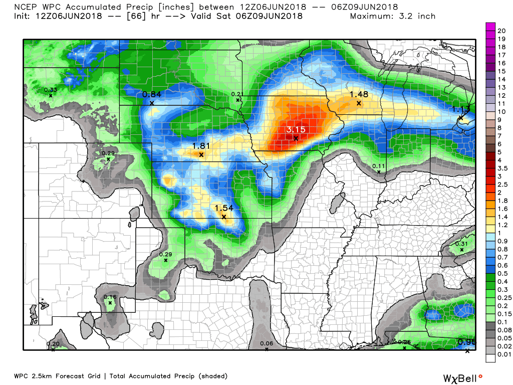
Here is the latest WPC rainfall forecast through 1 AM Saturday.
This map shows no significant or widespread rain in our region. I can’t rule out some isolated storms Thursday night. Most areas will remain dry. The same will go for Friday and first half of Friday night. Mostly dry.
Remember, summer thunderstorms can greatly skew these numbers. You can easily double rainfall totals under slow moving storms.
These graphics will not pick up on that.
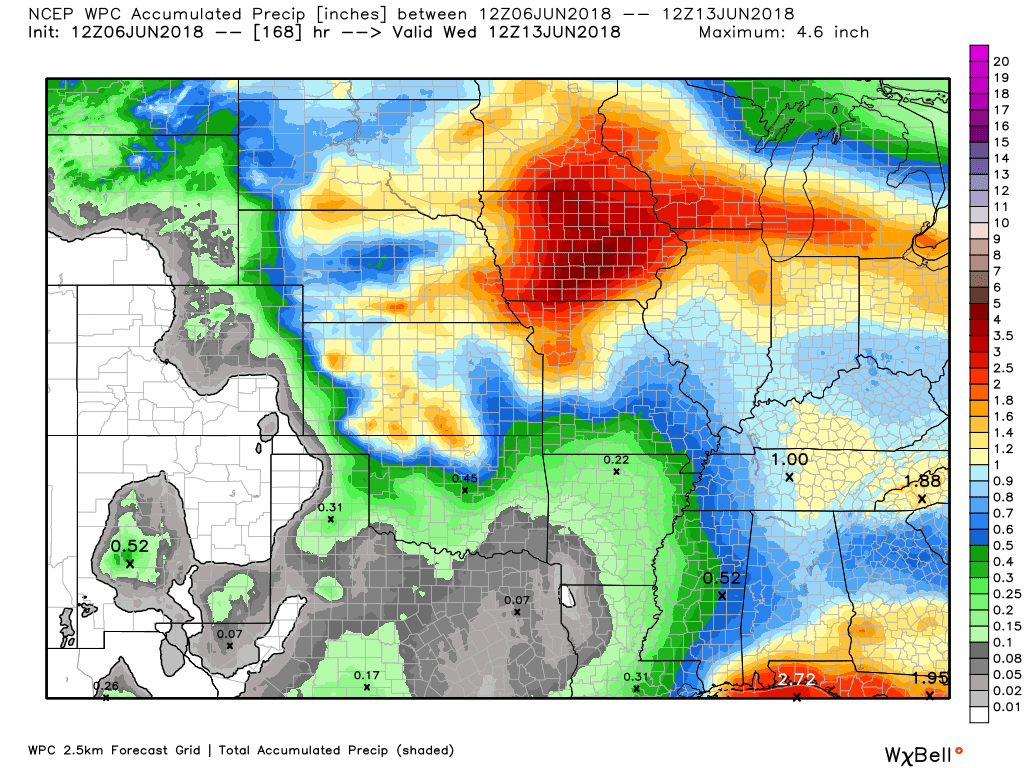
Here is the latest WPC rainfall forecast through day seven. Most of this falls Saturday and Sunday.

We offer interactive local city live radars and regional radars. If a radar does not update then try another one.
If a radar does not appear to be refreshing then hit Ctrl F5.
You may also try restarting your browser.
The local city view radars also have clickable warnings.During the winter months, you can track snow and ice by clicking the winterize button on the local city view interactive radars.

Questions? Broken links? Other?You may email me at beaudodson@usawx.com

The National Weather Service defines a severe thunderstorm as one that produces quarter size hail or larger, 58 mph winds or greater, and/or a tornado.
Today and tonight: No thunderstorm activity anticipated.
Thursday through Monday: Isolated storms will be possible over our northern counties (near Mt Vernon, IL) Thursday night (late).
Friday will only carry 10% chances of storms. Same for early Friday night. Isolated, if anything at all.
Thunderstorm chances should increase late Friday night and especially Saturday and Sunday.
Some of the storms will produce heavy downpours, frequent lightning, small hail, and gusty winds. I can’t rule out severe weather. The greatest time frame of concern should be Sunday and Sunday night as a cold front arrives.
![]()
Interactive live weather radar page. Choose the city nearest your location. If one of the cities does not work then try a nearby one. Click here.National map of weather watches and warnings. Click here.
Storm Prediction Center. Click here.
Weather Prediction Center. Click here.

Live lightning data: Click here.

Interactive GOES R satellite. Track clouds. Click here.

Here are the latest local river stage forecast numbers Click Here.Here are the latest lake stage forecast numbers for Kentucky Lake and Lake Barkley Click Here.

The spring and preliminary summer outlooks have been posted for subscribers. Scroll down to see the outlook.Not a subscriber? Learn more at this link.

Weather Headlines
- Calm weather today and tonight.
- I am monitoring thunderstorm chances as we move into the weekend.
Another calm weather day for the region. Slightly warmer today. Highs will top out in the middle to upper 80’s. A few spots in southeast Missouri may approach 90 degrees. A decent day for early June.
Temperatures will slowly inch upward over the coming days. Dew points will rise, as well. Rising dew points will mean a stickier feel to the air. A bit more like summer.
No significant weather anticipated today, tonight, or Thursday.
I did mention a small thunderstorm chance Thursday night over the northern portion of southern Illinois. Mostly near St Louis, MO towards Mt Vernon, IL. Even there chances will be less than 20%. More along the 10 to <20% range.
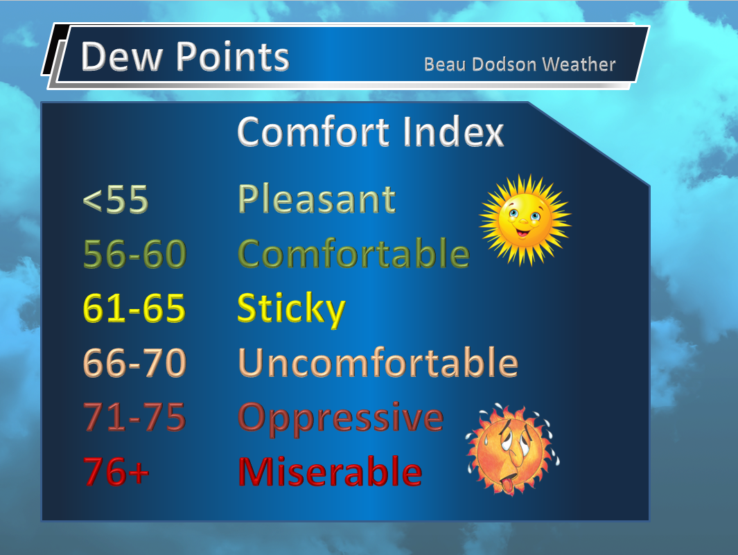
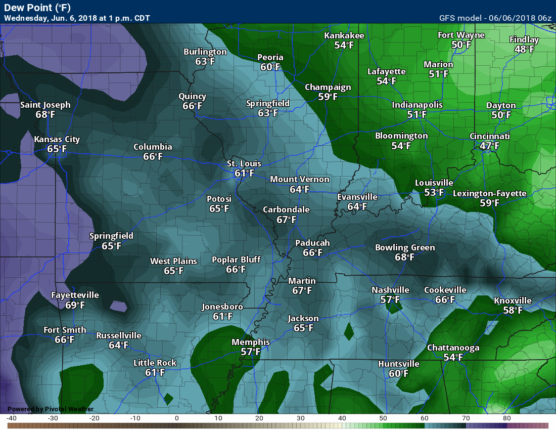
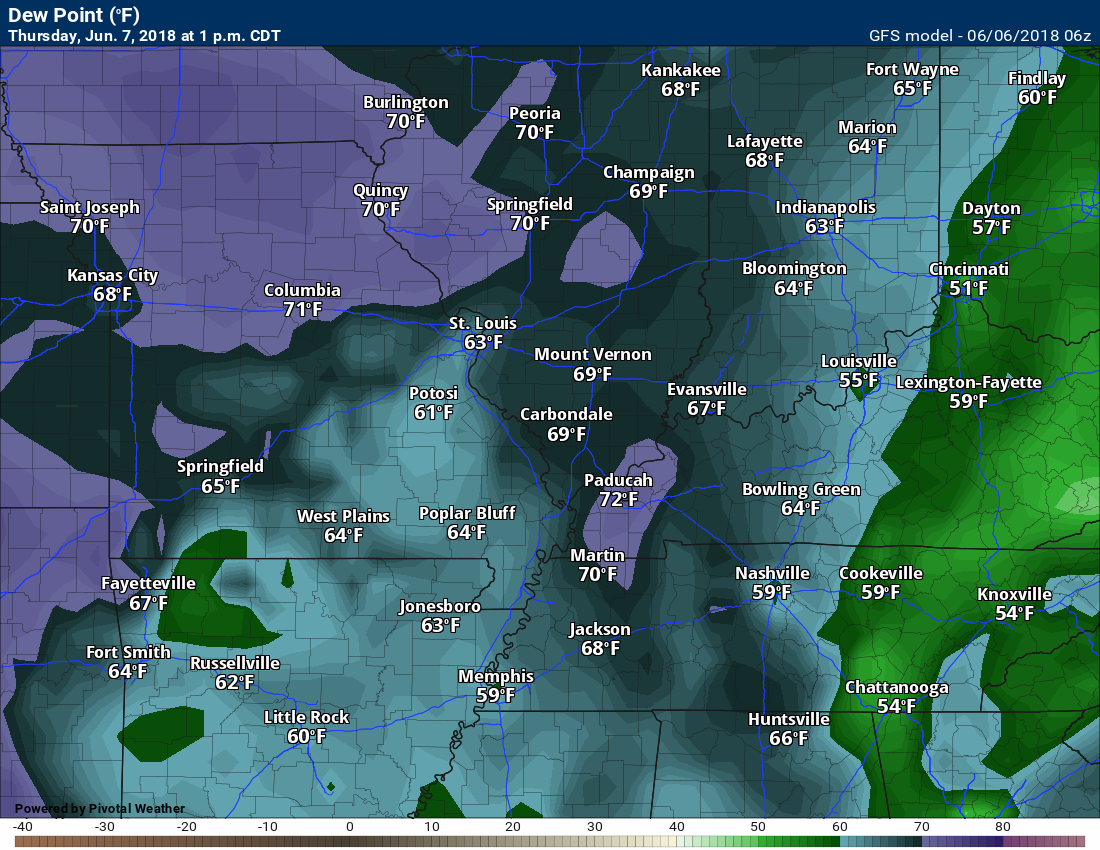
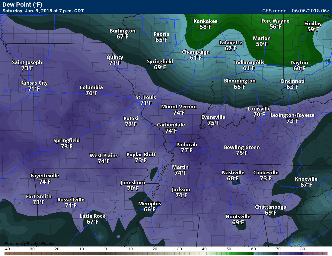
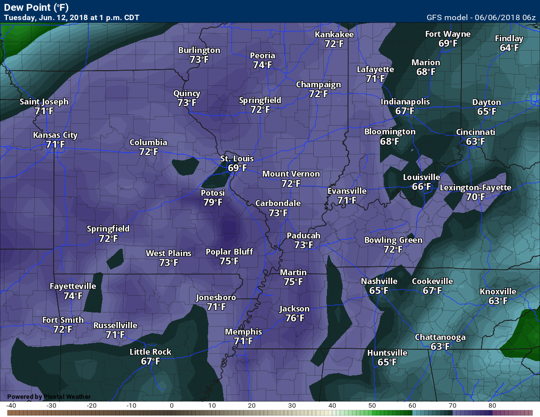
Let’s take a look at dew points over the coming days.
Today
Thursday afternoon
Saturday (muggy)
Sunday (muggy)

It appears the GFS model keeps muggy conditions well into next week. Not all models agree with this. It is something I will be monitoring.
If these high dew points stick around then so will thunderstorm chances.
Late Week Rain Chances
A frontal boundary will slip into the region Friday night into Sunday. This boundary will be the focus of showers and thunderstorms.
There is considerable debate among forecasters (and weather models) as to when thunderstorm chances will arrive Friday night into Monday.
The GFS model guidance shows rain Saturday. The EC guidance shows dry weather Saturday. Ensembles are mixed as to whether it will rain Saturday.
For now, I have kept thunderstorm chances in the Saturday forecast. I will continue to monitor forecast trends over the coming days and adjust as necessary.
Precipitation chances will increase Saturday night into Monday. I am more certain about that portion of the forecast.
If you have outdoor plans Saturday and Sunday then monitor the latest updates.
There will be plenty of moisture and warm temperatures. That usually means frequent lightning and heavy downpours. Some of the storms will likely have gusty winds, as well.
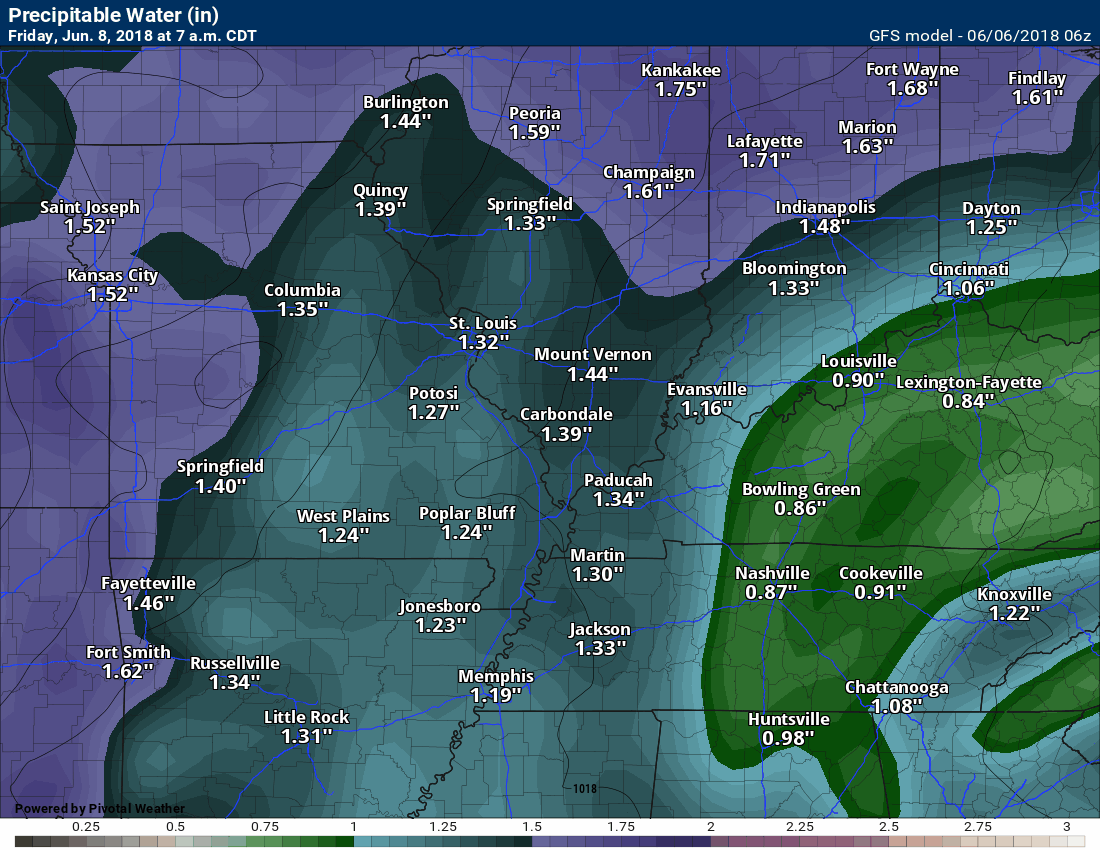
PWAT’s will be high. That is a measure of moisture. That equals locally heavy rain. This is especially true Sunday and Sunday night.
Here is the latest GFS model PWAT value animation. High PWAT values through all of next week (IF this model is correct).
That would mean additional heavy rain chances in the region (thunderstorms). I know some of you would like to bring hay in. There are uncertainties in the forecast.
Again, monitor updates moving forward.
![]()
![]()

A new weather podcast is now available! Weather Geeks (which you might remember is on The Weather Channel each Sunday)
To learn more visit their website. Click here.
![]()

WeatherBrains Episode 646
We couldn’t get Google Hangouts to function for our guest this week, so this week’s WeatherBrains is a discussion amongst the regulars about what is on their minds.
Other discussions in this weekly podcast include topics like:
- Subtropical Storm Alberto
- Extreme heat in the Southwest early in season
- Negativity and fighting on social media
- Problematic attempts at forecasting random summertime afternoon storms
- “First Alert Days” and their place in 2018 broadcast meteorology
- and more!
Previous episodes can be viewed by clicking here.
We offer interactive local city live radars and regional radars. If a radar does not update then try another one. If a radar does not appear to be refreshing then hit Ctrl F5. You may also try restarting your browser.
The local city view radars also have clickable warnings.
During the winter months, you can track snow and ice by clicking the winterize button on the local city view interactive radars.
You may email me at beaudodson@usawx.com
Find me on Facebook!

Find me on Twitter!

Did you know that a portion of your monthly subscription helps support local charity projects?
You can learn more about those projects by visiting the Shadow Angel Foundation website and the Beau Dodson News website.

I encourae subscribers to use the app vs regular text messaging. We have found text messaging to be delayed during severe weather. The app typically will receive the messages instantly. I recommend people have three to four methods of receiving their severe weather information.
Remember, my app and text alerts are hand typed and not computer generated. You are being given personal attention during significant weather events.
