WeatherTalk monthly operating costs can top $2000.00. Your $3 subscription helps pay for those costs. I work for you.
For $3 a month you can receive the following. You may choose to receive these via your WeatherTalk app or regular text messaging.
- Severe weather app/text alerts from my keyboard to your app/cell phone. These are hand typed by Beau. During tornado outbreaks, you will receive numerous app/text messages telling you exactly where the tornado is located.
- Daily forecast app/texts from my computer to your app/cell phone.
- Social media links sent directly to your app/cell phone. When I update the blog, videos, or Facebook you will receive the link.
- AWARE emails. These emails keep you well ahead of the storm. They give you several days of lead time before significant weather events.
- Direct access to Beau via text and email. Your very own personal meteorologist. I work for you!
- Missouri and Ohio Valley centered video updates
- Long-range weather videos
- Week one, two, three and four temperature and precipitation outlooks.
- Monthly outlooks.
- Your subscription also will help support several local charities.
Haven’t you subscribed? Subscribe at www.beaudodsonweather.com

Example of a recent severe weather alert. I issued this well before the official tornado warning. You would have had plenty of time for you and your family to seek shelter.


Your $3 per month also helps support these local charity projects.

I encourage subscribers to use the app vs regular text messaging. We have found text messaging to be delayed during severe weather. The app typically will receive the messages instantly. I recommend people have three to four methods of receiving their severe weather information.
Remember, my app and text alerts are hand typed and not computer generated. You are being given personal attention during significant weather events.

WWW.WEATHERTALK.COM subscribers, here is my day to day schedule for your weather products.


Interactive Radars:
Interactive live weather radar page. Choose the city nearest your location. If one of the city radars won’t load then try a nearby one. Click here.
June 04, 2018
Monday Forecast Details
Forecast: Morning sun. Comfortable temperatures and dew points. Nice day. Increasing clouds during the afternoon hours. We should remain dry.
Temperatures: MO ~ 80 to 84 IL ~ 80 to 84 KY ~ 80 to 84 TN ~ 80 to 84
What is the chance of precipitation? MO ~ 0% IL ~ 0% KY ~ 0% TN ~ 0%
Coverage of precipitation: None
Winds: North and northwest at 6 to 12 mph
What impacts are anticipated from the weather? None
My confidence in the forecast verifying: High
Is severe weather expected? No
The NWS defines severe weather as 58 mph wind or great, 1″ hail or larger, and/or tornadoes
Should I cancel my outdoor plans? No
UV Index: 8 to 10 High to very high
Sunrise: 5:35 AM
Monday Night Forecast Details:
Forecast: Any evening clouds will depart. Cool. Nice night. Lower dew points. Perhaps some patchy fog.
Temperatures: MO ~ 56 to 60 IL ~ 56 to 60 KY ~ 56 to 60 TN ~ 56 to 60
What is the chance of precipitation? MO ~ 0% IL ~ 0% KY ~ 0% TN ~ 0%
Coverage of precipitation: None
Winds: Light and variable winds.
What impacts are anticipated from the weather? None
My confidence in the forecast verifying: High
Is severe weather expected? No
The NWS defines severe weather as 58 mph wind or great, 1″ hail or larger, and/or tornadoes
Should I cancel my outdoor plans? No
Sunset: 8:11 PM
Moonrise: 12:10 AM Waning Gibbous
Moonset: 10:45 AM
June 05, 2018
Tuesday Forecast Details
Forecast: Mostly sunny. A nice day anticipated. Perhaps slightly warmer.
Temperatures: MO ~ 83 to 86 IL ~ 83 to 86 KY ~ 83 to 86 TN ~ 83 to 86
What is the chance of precipitation? MO ~ 0% IL ~ 0% KY ~ 0% TN ~ 0%
Coverage of precipitation: None
Winds: South and southwest at 4 to 8 mph
What impacts are anticipated from the weather? None
My confidence in the forecast verifying: High
Is severe weather expected? No
The NWS defines severe weather as 58 mph wind or great, 1″ hail or larger, and/or tornadoes
Should I cancel my outdoor plans? No
UV Index: 9 to 11 High to very high
Sunrise: 5:35 AM
Tuesday Night Forecast Details:
Forecast: Mostly clear and pleasant.
Temperatures: MO ~ 60 to 64 IL ~ 58 to 62 KY ~ 60 to 64 TN ~ 60 to 65
What is the chance of precipitation? MO ~ 0% IL ~ 0% KY ~ 0% TN ~ 0%
Coverage of precipitation: None
Winds: Southwest at 3 to 6 mph
What impacts are anticipated from the weather? None
My confidence in the forecast verifying: High
Is severe weather expected? No
The NWS defines severe weather as 58 mph wind or great, 1″ hail or larger, and/or tornadoes
Should I cancel my outdoor plans? No
Sunset: 8:12 PM
Moonrise: 12:46 AM Waning Gibbous
Moonset: 11:41 AM
June 06, 2018
Wednesday Forecast Details
Forecast: Partly to mostly sunny. Warmer and a bit more humid.
Temperatures: MO ~ 84 to 88 IL ~ 83 to 86 KY ~ 83 to 88 TN ~ 83 to 88
What is the chance of precipitation? MO ~ 0% IL ~ 0% KY ~ 0% TN ~ 0%
Coverage of precipitation: None anticipated
Winds: Light and variable winds
What impacts are anticipated from the weather? None
My confidence in the forecast verifying: High
Is severe weather expected? No
The NWS defines severe weather as 58 mph wind or great, 1″ hail or larger, and/or tornadoes
Should I cancel my outdoor plans? No
UV Index: 9 to 10 Very high
Sunrise: 5:34 AM
Wednesday Night Forecast Details:
Forecast: Mostly clear. A few passing clouds. More humid.
Temperatures: MO ~ 64 to 68 IL ~ 64 to 66 KY ~ 64 to 68 TN ~ 64 to 68
What is the chance of precipitation? MO ~ 0% IL ~ 0% KY ~ 0% TN ~ 0%
Coverage of precipitation: None anticipated
Winds: Southeast wind 3 to 6 mph
What impacts are anticipated from the weather? None
My confidence in the forecast verifying: High
Is severe weather expected? No
The NWS defines severe weather as 58 mph wind or great, 1″ hail or larger, and/or tornadoes
Should I cancel my outdoor plans? No
Sunset: 8:12 PM
Moonrise: 1:13 AM Last Quarter
Moonset: 12:39 PM
June 07, 2018
Thursday Forecast Details
Forecast: Mostly sunny. Afternoon Cumulus clouds building. Warm and humid. Most areas will remain dry. A slight chance of a thunderstorm mainly over southeast Illinois and northwest Kentucky.
Temperatures: MO ~ 85 to 90 IL ~ 85 to 90 KY ~ 85 to 90 TN ~ 85 to 90
What is the chance of precipitation? MO ~ 5% IL ~ 20% KY ~ 20% TN ~ 5%
Coverage of precipitation: None to isolated
Winds: South at 5 to 10 mph
What impacts are anticipated from the weather? Most likely none for most areas. Lightning and wet roads in isolated areas.
My confidence in the forecast verifying: Medium
Is severe weather expected? Unlikely
The NWS defines severe weather as 58 mph wind or great, 1″ hail or larger, and/or tornadoes
Should I cancel my outdoor plans? No
UV Index: 9 to 11 Very high
Sunrise: 5:34 AM
Thursday Night Forecast Details:
Forecast: Partly sunny. Warm. Humid. Most of the area will remain dry. An isolated thunderstorm possible.
Temperatures: MO ~ 65 to 70 IL ~ 65 to 70 KY ~ 65 to 70 TN ~ 65 to 70
What is the chance of precipitation? MO ~ 10% IL ~ 20% KY ~ 20% TN ~ 10%
Coverage of precipitation: None to isolated
Winds: South and southwest 5 to 10 mph
What impacts are anticipated from the weather? Isolated lightning. Isolated wet roadways.
My confidence in the forecast verifying: Medium
Is severe weather expected? Medium
The NWS defines severe weather as 58 mph wind or great, 1″ hail or larger, and/or tornadoes
Should I cancel my outdoor plans? No
Sunset: 8:13 PM
Moonrise: 1:50 AM Waning Crescent
Moonset: 1:37 PM
Rain chances will need to be monitored over the weekend. Adjustments in the rain percentage numbers are likely.
June 08, 2018
Friday Forecast Details
Forecast: Partly sunny. Warm and muggy. Most areas will remain dry. An isolated thunderstorm possible.
Temperatures: MO ~ 85 to 90 IL ~ 85 to 90 KY ~ 85 to 90 TN ~ 85 to 90
What is the chance of precipitation? MO ~ 20% IL ~ 20% KY ~ 20% TN ~ 20%
Coverage of precipitation: Isolated
Winds: Southwest at 5 to 10 mph
What impacts are anticipated from the weather? Most likely none. Perhaps an isolated wet roadway and lightning.
My confidence in the forecast verifying: Medium
Is severe weather expected? No
The NWS defines severe weather as 58 mph wind or great, 1″ hail or larger, and/or tornadoes
Should I cancel my outdoor plans? No
UV Index: 9 to 11 Very high
Sunrise: 5:34 AM
Friday Night Forecast Details:
Forecast: Increasing clouds. Most areas will remain dry. An isolated thunderstorm. Warm. Humid.
Temperatures: MO ~ 65 to 70 IL ~ 65 to 70 KY ~ 65 to 70 TN ~ 65 to 70
What is the chance of precipitation? MO ~ 20% IL ~ 20% KY ~ 20% TN ~ 20%
Coverage of precipitation: None to isolated
Winds: Southwest at 5 to 10 mph
What impacts are anticipated from the weather? None for most areas. Isolated wet roadways. Isolated lightning.
My confidence in the forecast verifying: Medium
Is severe weather expected? No
The NWS defines severe weather as 58 mph wind or great, 1″ hail or larger, and/or tornadoes
Should I cancel my outdoor plans? No
Sunset: 8:14 PM
Moonrise: 2:21 AM Waning Crescent
Moonset: 2:38 PM
June 09, 2018
Saturday Forecast Details
Forecast: Partly cloudy. Scattered storms again possible. Warm. Muggy.
Temperatures: MO ~ 85 to 88 IL ~85 to 88 KY ~ 85 to 88 TN ~ 85 to 88
What is the chance of precipitation? MO ~ 30% IL ~ 30% KY ~ 30% TN ~ 30%
Coverage of precipitation: Scattered
Winds: Southwest 7 to 14 mph and gusty
What impacts are anticipated from the weather? Wet roads. Heavy downpours. Lightning. Gusty winds near storms.
My confidence in the forecast verifying: Medium
Is severe weather expected? Monitor updates
The NWS defines severe weather as 58 mph wind or great, 1″ hail or larger, and/or tornadoes
Should I cancel my outdoor plans? Monitor updates
UV Index: 8 to 10 High
Sunrise: 5:34 AM
Saturday Night Forecast Details:
Forecast: Mostly cloudy. Showers and thunderstorms again possible.
Temperatures: MO ~ 65 to 70 IL ~ 65 to 70 KY ~ 65 to 70 TN ~ 65 to 70
What is the chance of precipitation? MO ~ 40% IL ~ 40% KY ~ 40% TN ~ 40%
Coverage of precipitation: Perhaps numerous
Winds: Southwest at 6 to 12 mph
What impacts are anticipated from the weather? Wet roads. Heavy downpours. Lightning. Gusty winds near storms.
My confidence in the forecast verifying: Medium
Is severe weather expected? Monitor updates
The NWS defines severe weather as 58 mph wind or great, 1″ hail or larger, and/or tornadoes
Should I cancel my outdoor plans? Monitor updates
Sunset: 8:14 PM
Moonrise: 2:53 AM Waning Crescent
Moonset: 3:40 PM
June 10, 2018
Sunday Forecast Details
Forecast: Mostly cloudy. Showers and thunderstorms possible. Warm and muggy.
Temperatures: MO ~ 82 to 86 IL ~ 82 to 86 KY ~ 82 to 86 TN ~ 82 to 86
What is the chance of precipitation? MO ~ 30% IL ~ 30% KY ~ 30% TN ~ 30%
Coverage of precipitation: Scattered
Winds: Southwest at 6 to 12 mph
What impacts are anticipated from the weather? Wet roadways. Lightning. Heavy downpours. Gusty winds.
My confidence in the forecast verifying: Medium
Is severe weather expected? Monitor updates
The NWS defines severe weather as 58 mph wind or great, 1″ hail or larger, and/or tornadoes
Should I cancel my outdoor plans? Monitor updates
UV Index: 8 to 10 High
Sunrise: 5:34 AM
Sunday Night Forecast Details:
Forecast: Mostly cloudy. Thunderstorms possible.
Temperatures: MO ~ 65 to 70 IL ~ 65 to 70 KY ~ 65 to 70 TN ~ 65 to 70
What is the chance of precipitation? MO ~ 30% IL ~ 30% KY ~ 30% TN ~ 30%
Coverage of precipitation: Scattered
Winds: Southwest 5 to 10 mph with gusts to 14
What impacts are anticipated from the weather? Wet roadways. Lightning. Locally heavy rain. Gusty winds.
My confidence in the forecast verifying: Medium
Is severe weather expected? Monitor updates
The NWS defines severe weather as 58 mph wind or great, 1″ hail or larger, and/or tornadoes
Should I cancel my outdoor plans? Monitor updates
Sunset: 8:15 PM
Moonrise: 3:26 AM Waning Crescent
Moonset: 4:46 PM
June 11, 2018
Monday Forecast Details
Forecast: Partly sunny. A chance of scattered thunderstorms.
Temperatures: MO ~ 82 to 86 IL ~ 82 to 86 KY ~ 82 to 86 TN ~ 82 to 86
What is the chance of precipitation? MO ~ 20% IL ~ 20% KY ~ 20% TN ~ 20%
Coverage of precipitation:
Winds:
What impacts are anticipated from the weather?
My confidence in the forecast verifying:
Is severe weather expected?
The NWS defines severe weather as 58 mph wind or great, 1″ hail or larger, and/or tornadoes
Should I cancel my outdoor plans?
UV Index: 8 to 10 High
Sunrise: 5:34 AM
Monday Night Forecast Details:
Forecast: Partly cloudy. Scattered showers and thunderstorms.
Temperatures: MO ~ 65 to 70 IL ~ 65 to 70 KY ~ 65 to 70 TN ~ 65 to 70
What is the chance of precipitation? MO ~ 20% IL ~ 20% KY ~ 20% TN ~ 20%
Coverage of precipitation:
Winds:
What impacts are anticipated from the weather?
My confidence in the forecast verifying:
Is severe weather expected?
The NWS defines severe weather as 58 mph wind or great, 1″ hail or larger, and/or tornadoes
Should I cancel my outdoor plans?
Sunset: 8:15 PM
Moonrise: 4:03 AM Waning Crescent
Moonset: 5:54 PM

We should remain dry through Wednesday.
Rain chances increase as we move towards Thursday through Sunday. Some of the rain could be heavy. Questions remain on the potential track of several thunderstorm complexes later this week.
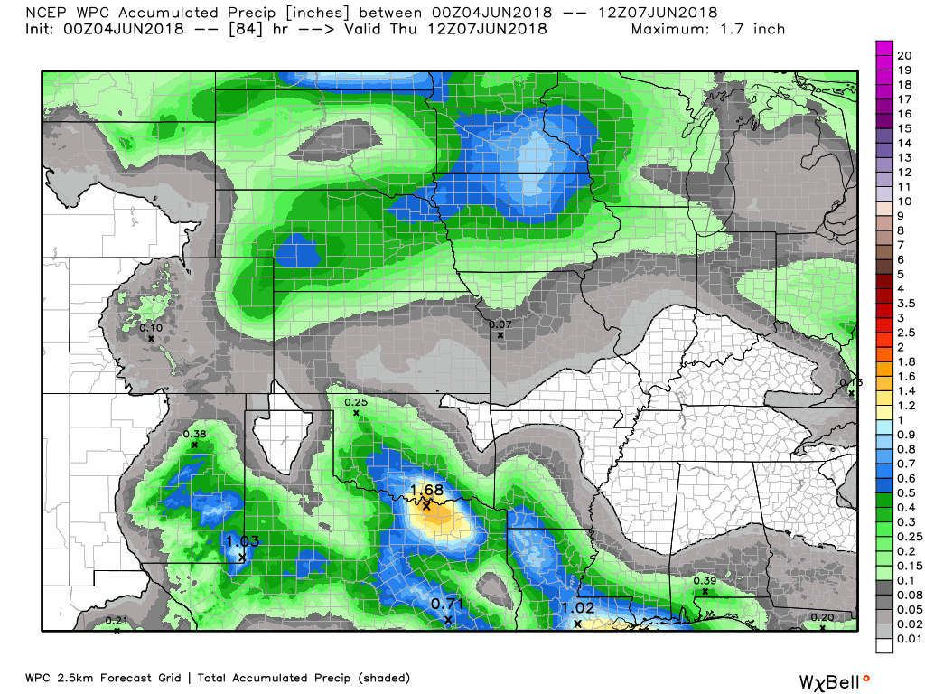
Here is the latest WPC rainfall forecast through Thursday morning.
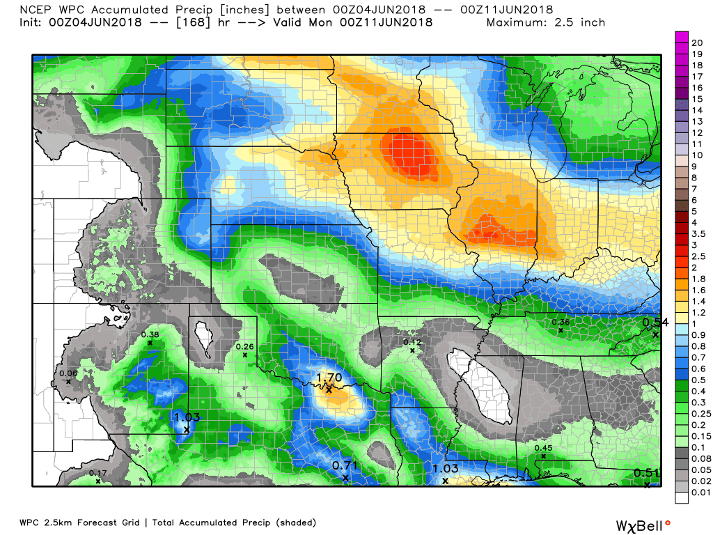
Here is the latest WPC rainfall forecast through day seven.

We offer interactive local city live radars and regional radars. If a radar does not update then try another one.
If a radar does not appear to be refreshing then hit Ctrl F5.
You may also try restarting your browser.
The local city view radars also have clickable warnings.During the winter months, you can track snow and ice by clicking the winterize button on the local city view interactive radars.

Questions? Broken links? Other?You may email me at beaudodson@usawx.com

The National Weather Service defines a severe thunderstorm as one that produces quarter size hail or larger, 58 mph winds or greater, and/or a tornado.
Monday through Wednesday: Odds favor no thunderstorm activity.
Thursday through Monday: Several rounds of thunderstorms will be possible. It is MCS season. MCS’s are thunderstorm complexes that typically move into our region from the northwest.
Some of the storms will produce heavy downpours, frequent lightning, small hail, and gusty winds. I can’t rule out severe weather but I will need to see more data before picking one day vs another for stronger thunderstorms. Monitor updates.
![]()
Interactive live weather radar page. Choose the city nearest your location. If one of the cities does not work then try a nearby one. Click here.National map of weather watches and warnings. Click here.
Storm Prediction Center. Click here.
Weather Prediction Center. Click here.

Live lightning data: Click here.

Interactive GOES R satellite. Track clouds. Click here.

Here are the latest local river stage forecast numbers Click Here.Here are the latest lake stage forecast numbers for Kentucky Lake and Lake Barkley Click Here.

The spring and preliminary summer outlooks have been posted for subscribers. Scroll down to see the outlook.Not a subscriber? Learn more at this link.

Weather Headlines
- Nice weather today into Wednesday. Less humid. Not as hot.
- Closely monitoring the potential of MCS’s later this week.
- Rising temperatures and rising dew points Thursday into the weekend. It will feel more humid.
I hope everyone had a nice weekend. It was a bit stormy. Some areas had wind damage and hail.
Sunday was the nicest day of the weekend. Dew points were lower and it felt nice outside. It was a bit windy. Area lakes were a bit wavy.
We will have nice weather today into Wednesday.
Daytime high temperatures will be in the 80’s. Dew points will remain in the middle 50’s to lower 60’s. Not too bad. Comfortable levels for June.
I am closely monitoring the weather pattern Thursday into the weekend.
A few thunderstorms may arrive as early as Thursday. A better chance appears to be in the cards by the weekend.
We may have to deal with an MCS or two. Still some discussion about that. Confidence isn’t great.
Either way, thunderstorm activity is anticipated to increase Saturday and Sunday.
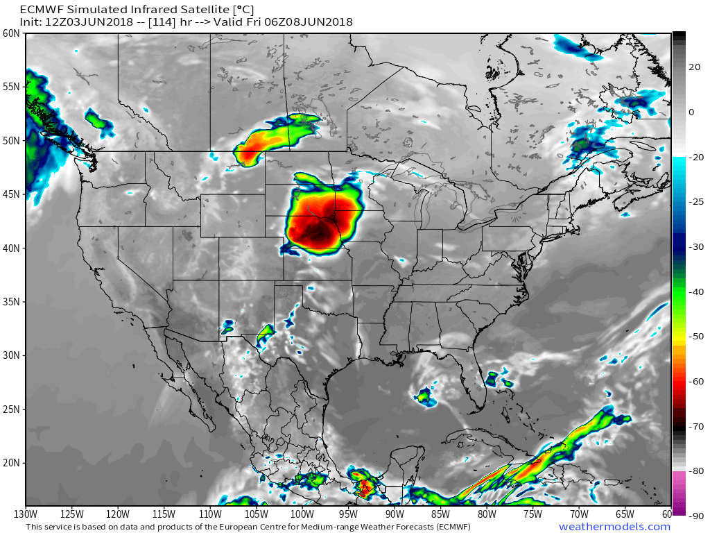
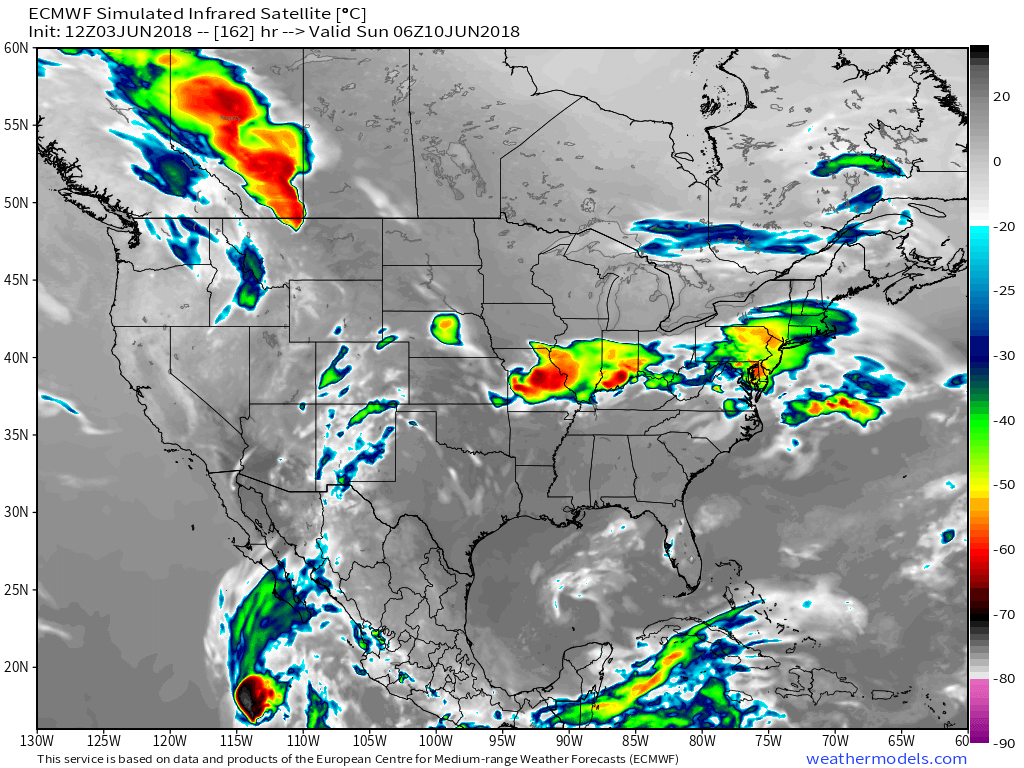
Here is the EC future-cast satellite. You can see the large thunderstorms forming well to our north and northwest. The question is whether they track into our region.
Each one will need to be monitored.
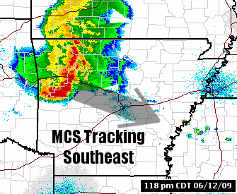
Here is the Friday, June 6th satellite. A complex of storms (MCS) over South Dakota, Nebraska, Minnesota, and Iowa.
What do the colors mean? Those are cloud temperatures. Colder temperatures are represented by the deep reds. High cloud tops are cumulonimbus clouds. Thunderstorms, in other words. You can assume heavy rain and strong storms are occurring underneath those colors.
This next one is Saturday morning. You can see the system has tracked east and southeast.

Here is the Saturday night/Sunday morning future-cast satellite view.
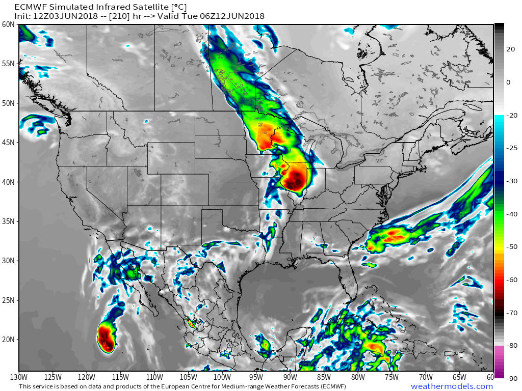
Here is the Tuesday, June 12th future-cast satellite view.
I will keep an eye on the trends over the coming days. For now, enjoy the nice weather.
What is an MCS?
A Mesoscale Convective System.
MCS’s occur every year in the central United States. They are actually responsible for much of the summer rainfall in the corn belt. They are a necessary process.
MCS’s can travel hundreds of miles and produce heavy rain, gusty winds, hail, frequent lightning, and even tornadoes.
At times MCS’s can bow outward. When this happens they produce widespread wind damage. We call this a bow echo. If there are enough damaging wind reports then we call it a Derecho. Derecho’s are not rare in our region but they also don’t occur every year.
Thankfully, most MCS’s do not produce widespread wind damage in our region.
They do, however, produce plenty of rain. They also typically do produce some reports of wind damage.
MCS’s normally begin in the afternoon hours as a cluster of thunderstorms. These storms then continue into the overnight hours. With time, they become a large mass of thunderstorms. They normally move east and southeast. They can continue past midnight and normally dissipate during the early morning hours.
They dissipate by moving into environments where the moisture, wind shear, lift, and instability are no longer able to sustain the system.
So how does an MCS form? MCS’s are formed from a process known as upscale growth. This is basically when the rain cooled air from several storms join forces to create a larger cold pool. This cold pool spreads out along the ground and acts as a mini cold front, triggering new storms as it moves along.
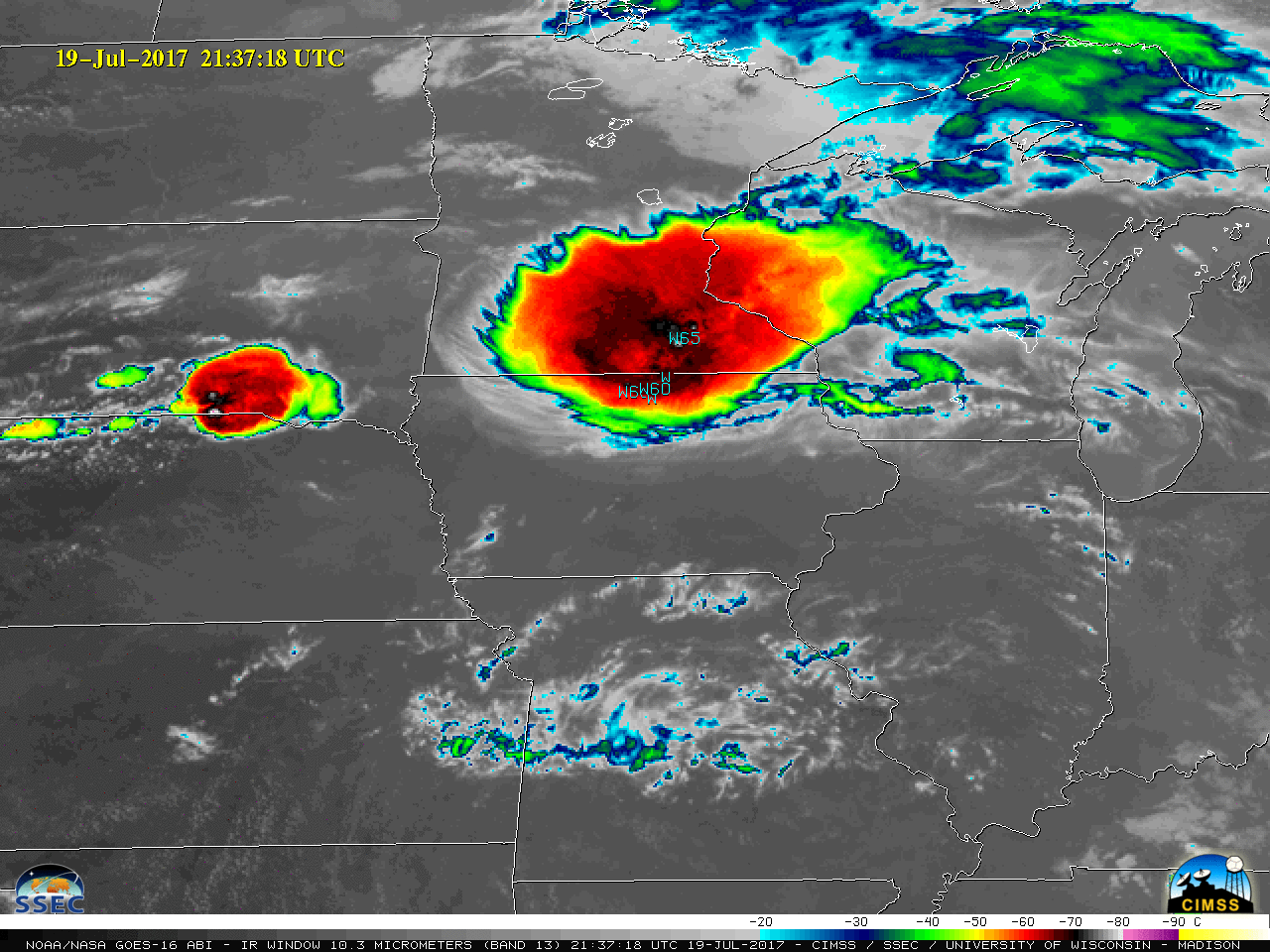
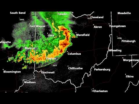
MCS’s can be quite dramatic on both satellite and radar images.
Here are some examples of MCS’s.
A satellite view of an MCS
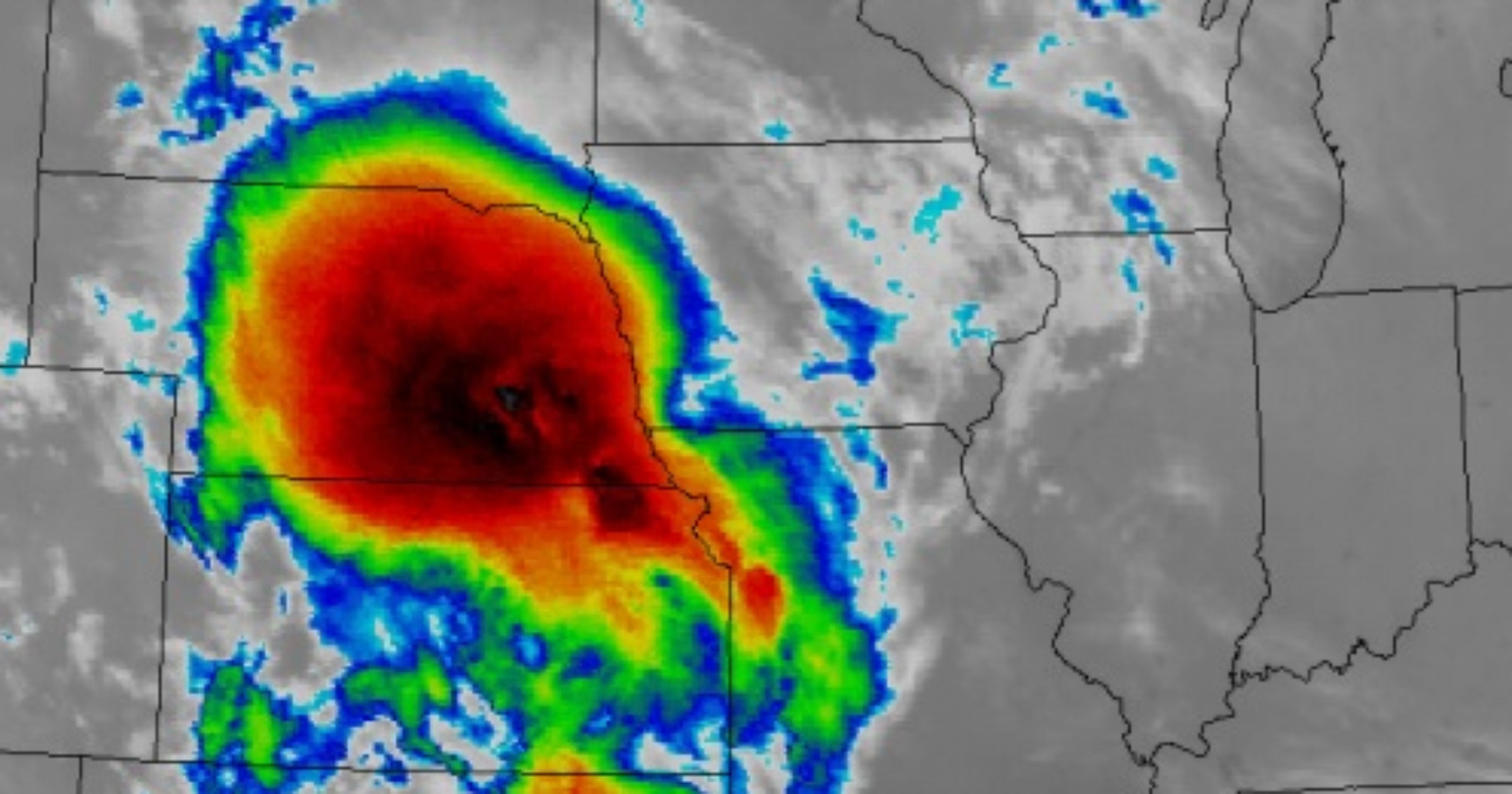
And radar (examples of MCS’s)
![]()

A new weather podcast is now available! Weather Geeks (which you might remember is on The Weather Channel each Sunday)
To learn more visit their website. Click here.
.![]()

WeatherBrains Episode 645
The first named storm of 2018 is now in the books, so we’re going to be talking with two experts in the area of tropical weather, Max Mayfield, left, and Bryan Norcross, right.
These two hurricane specialists currently work for WPLG in Fort Lauderdale. They both need no introduction. Max Mayfield, former Director of the National Hurricane Center, and Bryan Norcross, Mr. Hurricane who appeared on the show a few months ago when his book came out.
Max was unable to get connected to the hangout.
Other discussions in this weekly podcast include topics like:
- Extremes: 111 at Death Valley, CA, and 28 at Leadville, CO
- Alberto developed in SE Gulf and moved north through Alabama
- Humongous flooding in Ellicott City, MD
- 4 lightning deaths in US this year
- Astronomy Outlook with Tony Rice
- and more!
Previous episodes can be viewed by clicking here.

We offer interactive local city live radars and regional radars. If a radar does not update then try another one. If a radar does not appear to be refreshing then hit Ctrl F5. You may also try restarting your browser.
The local city view radars also have clickable warnings.
During the winter months, you can track snow and ice by clicking the winterize button on the local city view interactive radars.
You may email me at beaudodson@usawx.com
Find me on Facebook!

Find me on Twitter!

Did you know that a portion of your monthly subscription helps support local charity projects?
You can learn more about those projects by visiting the Shadow Angel Foundation website and the Beau Dodson News website.

I encourae subscribers to use the app vs regular text messaging. We have found text messaging to be delayed during severe weather. The app typically will receive the messages instantly. I recommend people have three to four methods of receiving their severe weather information.
Remember, my app and text alerts are hand typed and not computer generated. You are being given personal attention during significant weather events.
