For $3 a month you can receive the following. You may choose to receive these via your WeatherTalk app or regular text messaging.
- Severe weather app/text alerts from my keyboard to your app/cell phone. These are hand typed by Beau. During tornado outbreaks, you will receive numerous app/text messages telling you exactly where the tornado is located.
- Daily forecast app/texts from my computer to your app/cell phone.
- Social media links sent directly to your app/cell phone. When I update the blog, videos, or Facebook you will receive the link.
- AWARE emails. These emails keep you well ahead of the storm. They give you several days of lead time before significant weather events.
- Direct access to Beau via text and email. Your very own personal meteorologist. I work for you!
- Missouri and Ohio Valley centered video updates
- Long-range weather videos
- Week one, two, three and four temperature and precipitation outlooks.
- Monthly outlooks.
- Your subscription also will help support several local charities.
Haven’t you subscribed? Subscribe at www.beaudodsonweather.com

Example of a recent severe weather alert. I issued this well before the official tornado warning. You would have had plenty of time for you and your family to seek shelter.


Your $5 per month also helps support these local charity projects.

I encourage subscribers to use the app vs regular text messaging. We have found text messaging to be delayed during severe weather. The app typically will receive the messages instantly. I recommend people have three to four methods of receiving their severe weather information.
Remember, my app and text alerts are hand typed and not computer generated. You are being given personal attention during significant weather events.

WWW.WEATHERTALK.COM subscribers, here is my day to day schedule for your weather products.


We offer interactive local city live radars and regional radars. If a radar does not update then try another one. If a radar does not appear to be refreshing then hit Ctrl F5. You may also try restarting your browser.

.
June 29, 2018
Friday Forecast Details
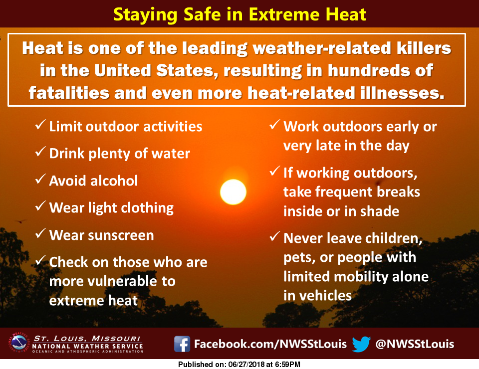
Excessive Heat into next week. Use care.
Forecast: Mostly sunny. A few clouds. Hot and humid. Isolated to widely scattered intense storms. Heat index above 105.
Temperatures: MO ~ 93 to 96 IL ~ 93 to 96 KY ~ 93 to 96 TN ~ 93 to 96
What is the chance of precipitation? MO ~ 30% IL ~ 30% KY ~ 30% TN ~ 30%
Coverage of precipitation: None to isolated
Winds: Southwest 7 to 14 mph with gusts to 18 mph
What impacts are anticipated from the weather? High heat index values could cause problems for young children, senior citizens, and those working outside.
My confidence in the forecast verifying: High
Is severe weather expected? Summer thunderstorms can occasionally produce pockets of high winds and hail.
The NWS defines severe weather as 58 mph wind or great, 1″ hail or larger, and/or tornadoes
Should I cancel my outdoor plans? No
UV Index: 9 to 10 Very high
Sunrise: 5:37 AM
Friday Night Forecast Details:
Forecast: Mostly clear. Warm and muggy. A thunderstorm possible.
Temperatures: MO ~ 72 to 76 IL ~ 72 to 76 KY ~ 72 to 76 TN ~ 72 to 76
What is the chance of precipitation? MO ~ 20% IL ~ 20% KY ~ 30% TN ~ 20%
Coverage of precipitation: Isolated to widely scattered.
Winds: South and southwest at 7 to 14 mph
What impacts are anticipated from the weather? Wet roads. Lightning. Gusty wind near storms.
My confidence in the forecast verifying: High
Is severe weather expected? Summer thunderstorms can occasionally produce pockets of high winds and hail.
The NWS defines severe weather as 58 mph wind or great, 1″ hail or larger, and/or tornadoes
Should I cancel my outdoor plans? No
Sunset: 8:19 PM
Moonrise: 9:30 PM Waning Gibbous
Moonset: 6:51 AM
June 30, 2018
Saturday Forecast Details
Forecast: Mostly sunny. A few clouds. Hot and muggy. Isolated thunderstorms possible. Heat index above 100.
Temperatures: MO ~ 93 to 96 IL ~ 93 to 96 KY ~ 93 to 96 TN ~ 93 to 96
What is the chance of precipitation? MO ~ 20% IL ~ 20% KY ~ 20% TN ~ 20%
Coverage of precipitation: None to isolated
Winds: South and southwest at 7 to 14 mph with gusts to 18
What impacts are anticipated from the weather? High heat index values could cause problems for young children, senior citizens, and those working outside. Summer thunderstorms can produce torrential downpours, gusty winds, and small hail. Frequent cloud to ground lightning, as well.
My confidence in the forecast verifying: High
Is severe weather expected? Summer thunderstorms can occasionally produce pockets of high winds and hail.
The NWS defines severe weather as 58 mph wind or great, 1″ hail or larger, and/or tornadoes
Should I cancel my outdoor plans? No
UV Index: 9 to 10 Very high
Sunrise: 5:37 AM
Saturday Night Forecast Details:
Forecast: Mostly clear. A few clouds. Warm and muggy.
Temperatures: MO ~ 72 to 76 IL ~ 72 to 76 KY ~ 72 to 76 TN ~ 72 to 76
What is the chance of precipitation? MO ~ 20% IL ~ 20% KY ~ 20% TN ~ 20%
Coverage of precipitation: None to isolated
Winds: South and southwest at 7 to 14 mph
What impacts are anticipated from the weather? Isolated wet roadways. Summer thunderstorms can produce torrential downpours, gusty winds, and small hail. Frequent cloud to ground lightning, as well.
My confidence in the forecast verifying: High
Is severe weather expected? Summer thunderstorms can occasionally produce pockets of high winds and hail.
The NWS defines severe weather as 58 mph wind or great, 1″ hail or larger, and/or tornadoes
Should I cancel my outdoor plans? No
Sunset: 8:19 PM
Moonrise: 10:10 PM Waning Gibbous
Moonset: 7:44 AM
July 1, 2018
Sunday Forecast Details
Forecast: Partly cloudy and hot. Humid. Isolated to perhaps scattered thunderstorms possible. Heat index above 100.
Temperatures: MO ~ 92 to 96 IL ~ 92 to 96 KY ~ 92 to 96 TN ~ 92 to 96
What is the chance of precipitation? MO ~ 30% IL ~ 30% KY ~ 30% TN ~ 30%
Coverage of precipitation: Isolated to perhaps scattered
Winds: South and southwest at 7 to 14 mph with gusts to 18
What impacts are anticipated from the weather? High heat index values could cause problems for young children, senior citizens, and those working outside. Summer thunderstorms can produce torrential downpours, gusty winds, and small hail. Frequent cloud to ground lightning, as well.
My confidence in the forecast verifying: Medium
Is severe weather expected? Summer thunderstorms can occasionally produce pockets of high winds and hail.
The NWS defines severe weather as 58 mph wind or great, 1″ hail or larger, and/or tornadoes
Should I cancel my outdoor plans? No
UV Index: 9 to 10 Very high
Sunrise: 5:38 AM
Sunday Night Forecast Details:
Forecast: Partly cloudy. Scattered thunderstorms. Warm and muggy.
Temperatures: MO ~ 72 to 76 IL ~ 72 to 76 KY ~ 72 to 76 TN ~ 72 to 76
What is the chance of precipitation? MO ~ 40% IL ~ 40% KY ~ 40% TN ~ 40%
Coverage of precipitation: Scattered
Winds: South and southwest at 7 to 14 mph
What impacts are anticipated from the weather? Scattered wet roadways. Summer thunderstorms can produce torrential downpours, gusty winds, and small hail. Frequent cloud to ground lightning, as well.
My confidence in the forecast verifying: Medium
Is severe weather expected? Summer thunderstorms can occasionally produce pockets of high winds and hail.
The NWS defines severe weather as 58 mph wind or great, 1″ hail or larger, and/or tornadoes
Should I cancel my outdoor plans? No
Sunset: 8:19 PM
Moonrise: 10:47 PM Waning Gibbous
Moonset: 8:38 AM
July 2, 2018
Monday Forecast Details
Forecast: Partly cloudy. Scattered thunderstorms. Hot and muggy.
Temperatures: MO ~ 92 to 96 IL ~ 92 to 96 KY ~ 92 to 96 TN ~ 92 to 96
What is the chance of precipitation? MO ~ 40% IL ~ 40% KY ~ 40% TN ~ 40%
Coverage of precipitation: Scattered
Winds: South and southwest at 7 to 14 mph with gusts to 18
What impacts are anticipated from the weather? High heat index values could cause problems for young children, senior citizens, and those working outside. Summer thunderstorms can produce torrential downpours, gusty winds, and small hail. Frequent cloud to ground lightning, as well.
My confidence in the forecast verifying: Medium
Is severe weather expected? Summer thunderstorms can occasionally produce pockets of high winds and hail.
The NWS defines severe weather as 58 mph wind or great, 1″ hail or larger, and/or tornadoes
Should I cancel my outdoor plans? No
UV Index: 9 to 10 Very high
Sunrise: 5:38 AM
Monday Night Forecast Details:
Forecast: Mostly clear. Warm and muggy. A few thunderstorms possible.
Temperatures: MO ~ 72 to 76 IL ~ 72 to 76 KY ~ 72 to 76 TN ~ 72 to 76
What is the chance of precipitation? MO ~ 30% IL ~ 30% KY ~ 30% TN ~ 30%
Coverage of precipitation: Isolated to perhaps scattered
Winds: South and southwest at 7 to 14 mph
What impacts are anticipated from the weather? Scattered wet roadways. Summer thunderstorms can produce torrential downpours, gusty winds, and small hail. Frequent cloud to ground lightning, as well.
My confidence in the forecast verifying: Medium
Is severe weather expected? Summer thunderstorms can occasionally produce pockets of high winds and hail.
The NWS defines severe weather as 58 mph wind or great, 1″ hail or larger, and/or tornadoes
Should I cancel my outdoor plans? No
Sunset: 8:19 PM
Moonrise: 11:20 PM Waning Gibbous
Moonset: 8:19 AM
July 3, 2018
Tuesday Forecast Details
Forecast: Partly to mostly sunny. Hot. Muggy. Heat index above 100 degrees. An isolated storm possible.
Temperatures: MO ~ 92 to 95 IL ~ 92 to 95 KY ~ 92 to 95 TN ~ 92 to 95
What is the chance of precipitation? MO ~ 20% IL ~ 30% KY ~ 20% TN ~ 20%
Coverage of precipitation: Isolated
Winds: South and southwest at 7 to 14 mph
What impacts are anticipated from the weather? High heat index values could cause problems for young children, senior citizens, and those working outside. Summer thunderstorms can produce torrential downpours, gusty winds, and small hail. Frequent cloud to ground lightning, as well.
My confidence in the forecast verifying: Medium
Is severe weather expected? Summer thunderstorms can occasionally produce pockets of high winds and hail.
The NWS defines severe weather as 58 mph wind or great, 1″ hail or larger, and/or tornadoes
Should I cancel my outdoor plans? No
UV Index: 9 to 10 Very high
Sunrise: 5:39 AM
Tuesday Night Forecast Details:
Forecast: Mostly clear. Warm and muggy.
Temperatures: MO ~ 72 to 76 IL ~ 72 to 76 KY ~ 72 to 76 TN ~ 72 to 76
What is the chance of precipitation? MO ~ 20% IL ~ 20% KY ~ 20% TN ~ 20%
Coverage of precipitation: Mostly likely none
Winds: South and southwest at 7 to 14 mph
What impacts are anticipated from the weather? Most likely none.
My confidence in the forecast verifying: Medium
Is severe weather expected? Summer thunderstorms can occasionally produce pockets of high winds and hail.
The NWS defines severe weather as 58 mph wind or great, 1″ hail or larger, and/or tornadoes
Should I cancel my outdoor plans? No
Sunset: 8:19 PM
Moonrise: 11:52 PM Waning Gibbous
Moonset: 10:31 AM
July 4, 2018
Wednesday Forecast Details
Forecast: Partly to mostly sunny. Hot. Muggy. An isolated thunderstorm possible. Heat index above 100 degrees.
Temperatures: MO ~ 88 to 94 IL ~ 88 to 94 KY ~ 88 to 94 TN ~ 88 to 94
What is the chance of precipitation? MO ~ 20% IL ~ 20% KY ~ 20% TN ~ 20%
Coverage of precipitation: Isolated
Winds: South and southwest at 7 to 14 mph with gusts to 18
What impacts are anticipated from the weather? Summer thunderstorms can produce torrential downpours, gusty winds, and small hail. Frequent cloud to ground lightning, as well.
My confidence in the forecast verifying: Medium
Is severe weather expected? Summer thunderstorms can occasionally produce pockets of high winds and hail.
The NWS defines severe weather as 58 mph wind or great, 1″ hail or larger, and/or tornadoes
Should I cancel my outdoor plans? No
UV Index: 9 to 10 Very high
Sunrise: 5:39 AM
Wednesday Night Forecast Details:
Forecast: Mostly clear. Warm and muggy.
Temperatures: MO ~ 72 to 76 IL ~ 72 to 76 KY ~ 72 to 76 TN ~ 72 to 76
What is the chance of precipitation? MO ~ 10% IL ~ 10% KY ~ 10% TN ~ 10%
Coverage of precipitation: Most likely none
Winds: South and southwest at 7 to 14 mph
What impacts are anticipated from the weather? Most likely none.
My confidence in the forecast verifying: Medium
Is severe weather expected? Summer thunderstorms can occasionally produce pockets of high winds and hail.
The NWS defines severe weather as 58 mph wind or great, 1″ hail or larger, and/or tornadoes
Should I cancel my outdoor plans? No
Sunset: 8:19 PM
Moonrise: 11:59 PM Waning Gibbous
Moonset: 11:27 AM
Learn more about the UV index readings. Click here.

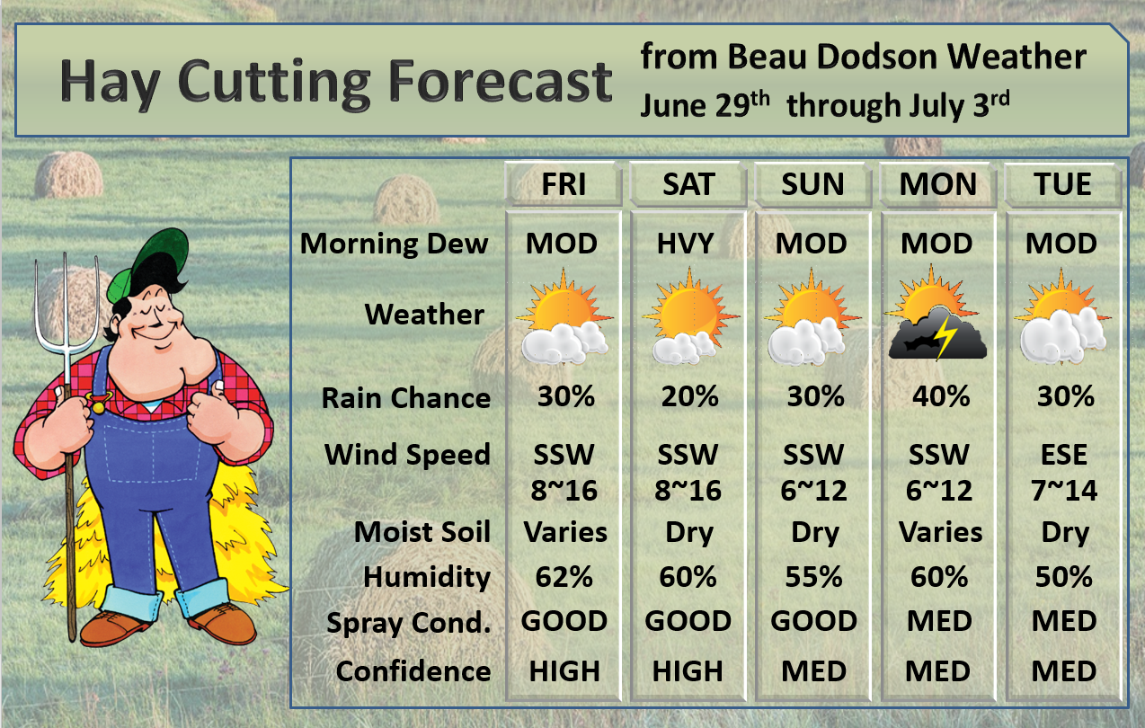
A fairly typical weather pattern for our local area.
A few storms are possible again today (Friday). Where storms form they will be heavy.
Smaller chances of rain on Saturday (<20%).
A few more storms Sunday into Monday as a cold front approaches the region. Locally heavy rain possible (summer storms).
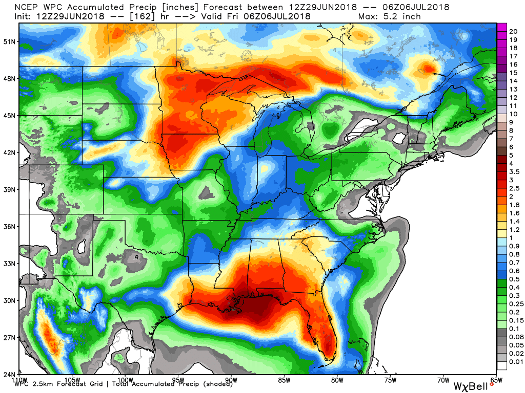
Here is the latest WPC / NOAA
A WIDE range of rainfall totals (even within the same county).
This graphic will not cover those wild swings in rainfall totals that occur from locally heavy thunderstorms.
.

We offer interactive local city live radars and regional radars. If a radar does not update then try another one.
If a radar does not appear to be refreshing then hit Ctrl F5 on your keyboard.
You may also try restarting your browser.
The local city view radars also have clickable warnings.
During the winter months, you can track snow and ice by clicking the winterize button on the local city view interactive radars.

Questions? Broken links? Other questions?
You may email me at beaudodson@usawx.com

The National Weather Service defines a severe thunderstorm as one that produces quarter size hail or larger, 58 mph winds or greater, and/or a tornado.
Friday through Monday. Isolated storms are possible Friday into Saturday. Most of the area will remain dry. We could see an uptick of thunderstorm chances Sunday and Monday. Some storms could produce heavy rain and gusty winds. Lightning, of course.
Isolated severe thunderstorms can’t be ruled out during the heat of the day. Monitor updates.
There will also be a risk of downburst winds. Downburst winds can exceed 50 mph.
What are downbursts?

Interactive live weather radar page. Choose the city nearest your location. If one of the cities does not work then try a nearby one. Click here.
National map of weather watches and warnings. Click here.
Storm Prediction Center. Click here.
Weather Prediction Center. Click here.

Live lightning data: Click here.

Interactive GOES R satellite. Track clouds. Click here.

Here are the latest local river stage forecast numbers Click Here.
Here are the latest lake stage forecast numbers for Kentucky Lake and Lake Barkley Click Here.

The spring and preliminary summer outlooks have been posted for subscribers. Scroll down to see the outlook.Not a subscriber? Learn more at this link.

Weather Headlines
- Major damaging wind event for the region
- The heat is going to be a big topic over the coming seven to ten days
- Scattered thunderstorms
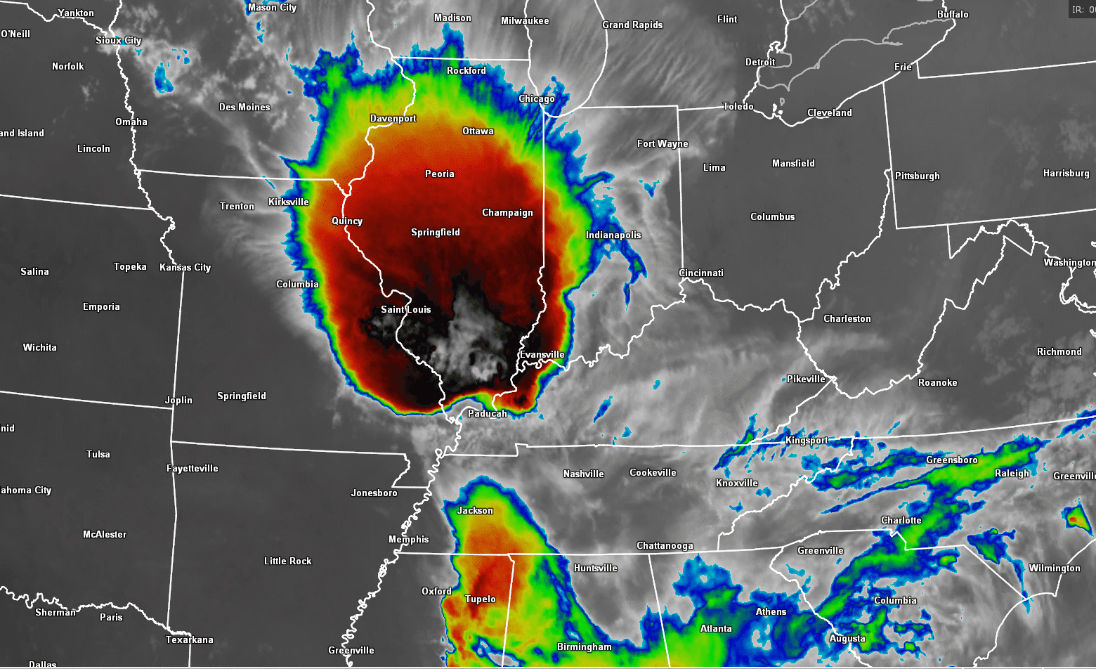
Widespread wind damage struck the region Thursday afternoon and night.
This is what the radar looked like as the storm pushed across westernKentucky.
Notice that bowing of the line? That is a good indication that damaging wind is occurring.

Many areas across southern Illinois and western Kentucky reported wind damage. Portions of southeast Missouri and northwest Tennessee, as well.
Wind gusts of 55 to 70 mph were common.
The storm cluster moved out of Iowa early Thursday afternoon and then started to dive south-southeast across Missouri and Illinois. It eventually turned southwest.
Many areas were without power last night and still are without power this morning.
Here is the IR satellite view of the storm. This image shows you cold cloud tops in red. Those whites in the red are very cold temperatures. High clouds tops would be thunderstorms.
Impressive system.
There will be a few thunderstorms today. Storms that form will be heavy with frequent lightning and gusty winds. I can’t rule out isolated severe thunderstorms.
The bigger story will be the oppressive heat and high dew points. High dew points equal muggy conditions.
Heat indexes on Thursday topped 80 degrees across much of southern Illinois. It is rare to see dew points that high in our region. Especially the widespread nature of the high dew points.
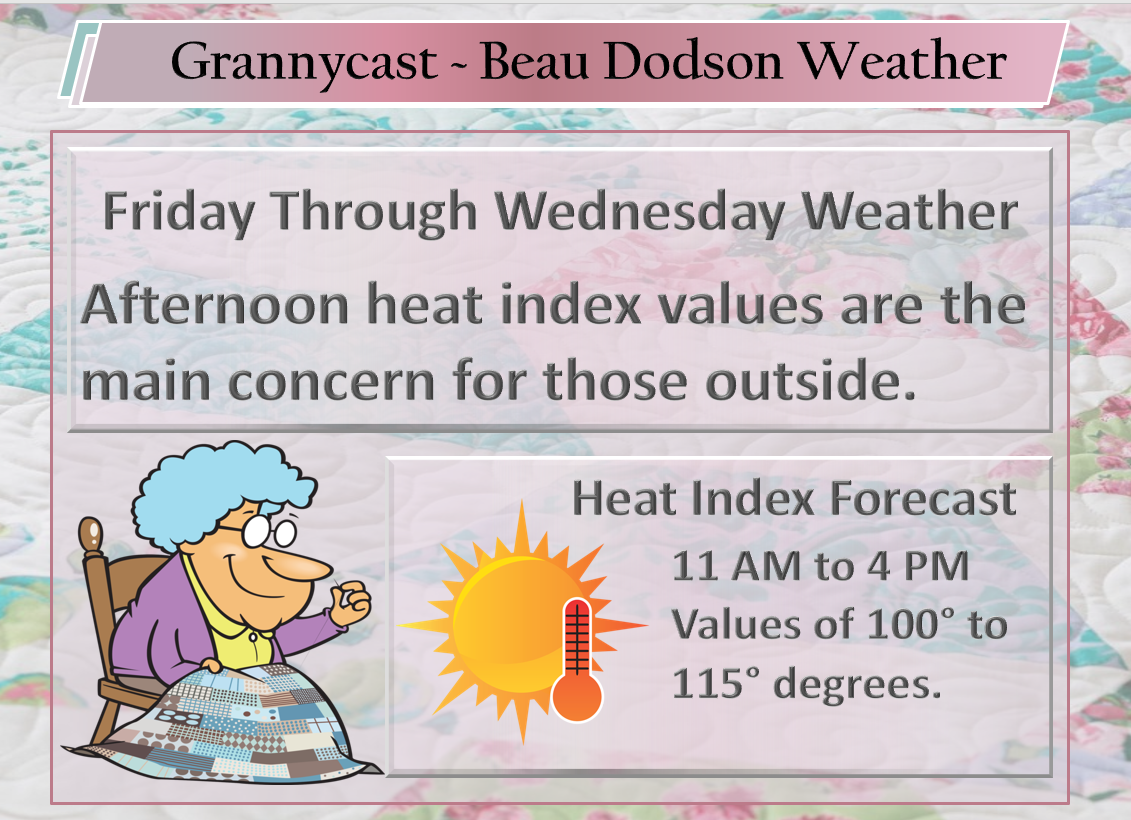
High temperatures today through next Friday will likely range from 90 to 98 degrees. Each day, heat index values of 100 to 115 degrees will be possible during the late morning and afternoon hours.
Overnight lows will remain in the 70’s through next week,
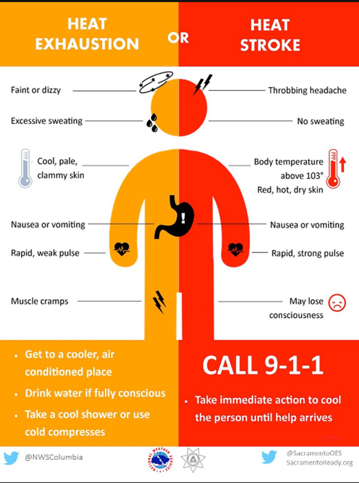
The longevity of the heat wave will be harsh on our senior citizen friends, young children, and those working outside.
Do you know the symptoms of heat illnesses? Most people do not.
Those cleaning up from the storm should use care.
![]()
Outlook definitions
EQ = Equal chances of above or below normal
BN= Below normal
M/BN = Much below normal
AN = Above normal
M/AN = Much above normal
E/AN = Extremely above normal.
Normal high temperatures for this time of the year are around 88 degrees.
Normal low temperatures for this time of the year are around 65 degrees.
Normal precipitation during this time period ranges from 0.60″ to 0.80″
This outlook covers June 12th through June 18th
These graphics are for subscribers.
Subscribe at www.weathertalk.com

These graphics are for subscribers.
The precipitation forecast is PERCENT OF NORMAL. For example, if your normal rainfall is 1.00″ and the graphic shows 10%, then that would mean 0.10″ of rain is anticipated.
These graphics are for subscribers.
Subscribe at www.weathertalk.com

This outlook covers June 22nd through July 5th
These graphics are for subscribers.
Subscribe at www.weathertalk.com
And precipitation
These graphics are for subscribers.
Subscribe at www.weathertalk.com
June temperature and precipitation outlook
These graphics are for subscribers.
Subscribe at www.weathertalk.com

Outlook definitions
EQ = Equal chances of above or below normal
BN= Below normal
M/BN = Much below normal
AN = Above normal
M/AN = Much above normal
E/AN = Extremely above normal.
Temperature outlook for April through June.
These graphics are for subscribers.
Subscribe at www.weathertalk.com
Precipitation outlook for March through May.
These graphics are for subscribers.
Subscribe at www.weathertalk.com
Temperature outlook for June through August.
These graphics are for subscribers.
Subscribe at www.weathertalk.com
July temperature and precipitation outlook
These graphics are for subscribers.
Subscribe at www.weathertalk.com
August temperature and precipitation outlook
These graphics are for subscribers.
Subscribe at www.weathertalk.com
![]()

A new weather podcast is now available! Weather Geeks (which you might remember is on The Weather Channel each Sunday)
To learn more visit their website. Click here.
![]()

WeatherBrains Episode 649
Joining us on this episode of WeatherBrains are guest WeatherBrains Benjamin May and Joe Tankersley. Ben came to marketing as a senior executive at Chateau St. Michelle winery. He left this to develop public safety-related “edu-tainment” programs at Disney in Orlando.
Teaming with Disney Imagineer Joe Tankersley, they managed to get together a huge pot of funding and create a program that successfully improved preparedness behaviors for hundreds of thousands of people. They teamed with FLASH, and through that, connected with many of the big names in our field. Through those connections, both men continue to be involved with NWS safety campaigns.
Also joining us from KMBC-TV in Kansas City is guest panelist Nick Bender. Nick is the morning meteorologist there and the proud father of a new baby boy.
Other discussions in this weekly podcast include topics like:
- Extremes: 120 at Death Valley, CA, and 30 at Gothic, CO
- Large slight risk area Tuesday centered on IL and MO
- Hot in Southwest US into TX
- Atlantic Basin quiet for now
- Eastern Pacific Basin has Daniel and another disturbed area
- Astronomy Outlook with Tony Rice
- and more!
Previous episodes can be viewed by clicking here.
We offer interactive local city live radars and regional radars. If a radar does not update then try another one. If a radar does not appear to be refreshing then hit Ctrl F5. You may also try restarting your browser.
The local city view radars also have clickable warnings.
During the winter months, you can track snow and ice by clicking the winterize button on the local city view interactive radars.
You may email me at beaudodson@usawx.com
Find me on Facebook!

Find me on Twitter!

Did you know that a portion of your monthly subscription helps support local charity projects?
You can learn more about those projects by visiting the Shadow Angel Foundation website and the Beau Dodson News website.

I encourage subscribers to use the app vs regular text messaging. We have found text messaging to be delayed during severe weather. The app typically will receive the messages instantly. I recommend people have three to four methods of receiving their severe weather information.
Remember, my app and text alerts are hand typed and not computer generated. You are being given personal attention during significant weather events.
