


Videos can be viewed at this link. Long Range Video Update
If you believe you missed a video then you can also click the LIVE FEED link on the Weather Talk website. That page holds links for several days.
I can text you the videos, as well. Make sure you have text option FOUR turned on. That would be the Weather Extra text option. Sign up for the text messages at www.beaudodsonweather.com
.
 .
..
This forecast update covers southern Illinois, southeast Missouri, western Kentucky. and northwest Tennessee.
.
The following link is for Weather Text subscribers. This is the page where short and long range video outlooks have been posted. The videos are being produced by a team of meteorologists. Some of the best in the region.
https://weathertalk.com/app/beaucast
.
June 25, 2017
Sunday Night Forecast Details:
Forecast: Clear with a few clouds late. Breezy in the evening. More clouds in southeast Missouri. A sprinkle possible late tonight over southeast Missouri.
Temperatures: MO ~ 56 to 62 IL ~ 56 to 62 KY ~ 56 to 62 TN ~ 56 to 62
Winds: W NW 6 to 12 mph. Gusts above 18 mph during the evening hours.
My confidence in the forecast verifying: Medium. Some adjustments possible.
What impacts are anticipated from the weather? Should remain dry through the night.
Is severe weather expected? No
The NWS defines severe weather as 58 mph winds or great, 1″ hail or larger, and/or tornadoes
What is the chance of precipitation: MO ~ 20% IL ~ 10% KY ~ 10% TN ~ 10%
Coverage of precipitation: We should remain dry. Perhaps a sprinkle or light shower over southeast Missouri after 2 am. Atmosphere is fairly dry so rain may evaporate.
Should I cancel my outdoor plans? No
.
June 26, 2017
Monday Forecast Details
Forecast: A mix of sun and clouds. A slight chance for a light shower before 10 am over southeast Missouri. I will be monitoring an incoming front from the northwest. Some data wants to pop a few showers and thunderstorms during the afternoon hours. Mainly over southeast Missouri and perhaps portions of southern Illinois. Rain and thunderstorm chances will increase on Monday night.
Temperatures: MO ~ 76 to 82 IL ~ 76 to 82 KY ~ 76 to 82 TN ~ 76 to 82
Winds: N NW at 5 to 10 mph. Winds becoming westerly.
What impacts are anticipated from the weather? During the late afternoon hours perhaps some wet roadways. Perhaps some lightning.
My confidence in the forecast verifying: Medium. Some adjustments are possible.
Is severe weather expected? No
The NWS defines severe weather as 58 mph winds or great, 1″ hail or larger, and/or tornadoes
What is the chance of precipitation? MO ~ 40% late in the day IL ~ 30% late in the day KY ~ 20% late in the day TN ~ 20% late in the day
Coverage of precipitation: Perhaps widely scattered showers and storms late in the afternoon.
Should I cancel my outdoor plans? No, but check radars
.
Monday Night Forecast Details:
Forecast: Cloudy. A period of showers and possibly a thunderstorm. Cool temperatures.
Temperatures: MO ~56 to 62 IL ~ 56 to 62 KY ~ 56 to 62 TN ~ 56 to 62
Winds: W 5 to 10 mph. Winds becoming variable at 0 to 5 mph late.
My confidence in the forecast verifying: Medium. Some adjustments are possible.
What impacts are anticipated from the weather? Wet roadways. Perhaps some lightning.
Is severe weather expected? No
The NWS defines severe weather as 58 mph winds or great, 1″ hail or larger, and/or tornadoes
What is the chance of precipitation: MO ~ 60% IL ~ 60% KY ~ 60% TN ~ 60%
Coverage of precipitation: Scattered. A band of showers and thunderstorms.
Should I cancel my outdoor plans? No, but check radars. Rain is possible during the evening hours.
.
June 27, 2017
Tuesday Forecast Details
Forecast: Some morning clouds possible, especially over our southern counties. Rain should have ended. Becoming partly to mostly sunny. Pleasant temperatures for late June.
Temperatures: MO ~ 76 to 84 IL ~ 76 to 84 KY ~ 78 to 84 TN ~ 78 to 84
Winds: N NE at 5 to 10 mph. Winds becoming variable and eventually may become south and southeast
What impacts are anticipated from the weather? Most likely none. Rain should have ended.
My confidence in the forecast verifying: High. This forecast should have verified.
Is severe weather expected? No
The NWS defines severe weather as 58 mph winds or great, 1″ hail or larger, and/or tornadoes
What is the chance of precipitation? MO ~ 20% (before 8 am) IL ~ 20% (before 8 am) KY ~ 20% (before 8 am) TN ~ 30% (before 8 am)
Coverage of precipitation: Most likely none. Morning rain should have ended by sunrise or shortly afterwards.
Should I cancel my outdoor plans? No, but check radars before 8 am.
.
Tuesday Night Forecast Details:
Forecast: Mostly clear. Cool. Perhaps some patchy fog.
Temperatures: MO ~ 58 to 64 IL ~ 58 to 64 KY ~ 58 to 65 TN ~ 60 to 65
Winds: South and southeast 3 to 6 mph
My confidence in the forecast verifying: High. This forecast should verify.
What impacts are anticipated from the weather? None.
Is severe weather expected? No
The NWS defines severe weather as 58 mph winds or great, 1″ hail or larger, and/or tornadoes
What is the chance of precipitation: MO ~ 0% IL ~ 0% KY ~ 0% TN ~ 0%
Coverage of precipitation: None.
Should I cancel my outdoor plans? No
.
June 28, 2017
Wednesday Forecast Details
Forecast: Partly to mostly sunny. Warmer. Breezy, at times. A little more humid as dew points rise into the lower to middle 60’s.
Temperatures: MO ~ 85 to 90 IL ~ 85 to 90 KY ~ 85 to 90 TN ~ 85 to 90
Winds: South and southwest at 7 to 14 mph with higher gusts possible.
What impacts are anticipated from the weather? None
My confidence in the forecast verifying: High. This forecast should verify.
Is severe weather expected? No
The NWS defines severe weather as 58 mph winds or great, 1″ hail or larger, and/or tornadoes
What is the chance of precipitation? MO ~ 0% IL ~ 0% KY ~ 0% TN ~ 0%
Coverage of precipitation: None
Should I cancel my outdoor plans? No
.
Wednesday Night Forecast Details:
Forecast: Mostly clear to partly cloudy. Warmer. Perhaps some clouds late at night.
Temperatures: MO ~ 68 to 74 IL ~ 66 to 72 KY ~ 68 to 74 TN ~ 70 to 74
Winds: South and southwest 6 to 12 mph
My confidence in the forecast verifying: High. This forecast should verify.
What impacts are anticipated from the weather? None.
Is severe weather expected? No
The NWS defines severe weather as 58 mph winds or great, 1″ hail or larger, and/or tornadoes
What is the chance of precipitation: MO ~ 10% IL ~ 10% KY ~ 0% TN ~ 0%
Coverage of precipitation: None.
Should I cancel my outdoor plans?No
.
June 29, 2017
Thursday Forecast Details
Forecast: Partly to mostly sunny. More humid. Warmer. Breezy, at times. A chance for an afternoon thunderstorm. Perhaps the best chance will be over our northern counties. That would be from Farmington, Missouri into Mt Vernon, and into the Carmi, Illinois region.
Temperatures: MO ~ 85 to 90 IL ~ 85 to 90 KY ~ 85 to 90 TN ~ 85 to 90
Winds: South and southwest at 8 to 16 mph with higher gusts possible.
What impacts are anticipated from the weather? Isolated lightning. Isolated wet roadways
My confidence in the forecast verifying: Medium. Some adjustments are possible
Is severe weather expected? Unlikely
The NWS defines severe weather as 58 mph winds or great, 1″ hail or larger, and/or tornadoes
What is the chance of precipitation? MO ~ 30% IL ~ 30% KY ~ 20% TN ~ 20%
Coverage of precipitation: Isolated to scattered
Should I cancel my outdoor plans? No, but monitor updates and radars.
.
Thursday Night Forecast Details:
Forecast: Some clouds. Mild. A chance for a thunderstorm over the northern portions of southeast Missouri and northern portions of southern Illinois. Lesser chances elsewhere. More humid.
Temperatures: MO ~ 70 to 74 IL ~ 70 to 74 KY ~ 70 to 74 TN ~ 70 to 74
Winds: South and southwest 6 to 12 mph
My confidence in the forecast verifying: Medium. Some adjustments possible.
What impacts are anticipated from the weather? Isolated lighting and wet roadways.
Is severe weather expected? Unlikely, but monitor updates.
The NWS defines severe weather as 58 mph winds or great, 1″ hail or larger, and/or tornadoes
What is the chance of precipitation: MO ~ 30% IL ~ 30% KY ~ 20% TN ~ 20%
Coverage of precipitation: Isolated.
Should I cancel my outdoor plans? No, but monitor updates and radars.
.
June 30, 2017
Friday Forecast Details
Forecast: A mix of sun and clouds. Warmer and humid. Breezy, at times. A chance for a thunderstorm.
Temperatures: MO ~ 84 to 88 IL ~ 84 to 88 KY ~ 84 to 88 TN ~ 84 to 88
Winds: South and southwest at 10 to 20 mph with higher gusts possible.
What impacts are anticipated from the weather? Lightning. Wet roadways
My confidence in the forecast verifying: Medium. Some adjustments are possible
Is severe weather expected? Monitor updates
The NWS defines severe weather as 58 mph winds or great, 1″ hail or larger, and/or tornadoes
What is the chance of precipitation? MO ~ 40% IL ~ 40% KY ~ 40% TN ~ 40%
Coverage of precipitation: Scattered
Should I cancel my outdoor plans? No, but monitor updates and radars.
.
Friday Night Forecast Details:
Forecast: Partly cloudy. Warmer. A chance for a shower or thunderstorm.
Temperatures: MO ~ 70 to 74 IL ~ 70 to 74 KY ~ 70 to 74 TN ~ 70 to 74
Winds: South and southwest at 6 to 12 mph
What impacts are anticipated from the weather? Lightning. Wet roadways
My confidence in the forecast verifying: Medium. Some adjustments are possible
Is severe weather expected? Monitor updates
The NWS defines severe weather as 58 mph winds or great, 1″ hail or larger, and/or tornadoes
What is the chance of precipitation? MO ~ 30% IL ~ 30% KY ~ 30% TN ~ 30%
Coverage of precipitation:Scattered
Should I cancel my outdoor plans? No, but monitor updates and radars.
.
July 1, 2017
Saturday Forecast Details
Forecast: Quite a few clouds. A chance for thunderstorms.
Temperatures: MO ~ 84 to 88 IL ~ 84 to 88 KY ~ 84 to 88 TN ~ 84 to 88
Winds: South and southwest at 10 to 20 mph with higher gusts possible.
What impacts are anticipated from the weather? Lightning. Wet roadways
My confidence in the forecast verifying: Medium. Some adjustments are possible
Is severe weather expected? Monitor updates
The NWS defines severe weather as 58 mph winds or great, 1″ hail or larger, and/or tornadoes
What is the chance of precipitation? MO ~ 50% IL ~ 50% KY ~ 50% TN ~ 50%
Coverage of precipitation: Scattered
Should I cancel my outdoor plans? No, but monitor updates and radars.
.
Saturday Night Forecast Details:
Forecast: Partly cloudy. Warmer. A chance for a shower or thunderstorm.
Temperatures: MO ~ 70 to 74 IL ~ 70 to 74 KY ~ 70 to 74 TN ~ 70 to 74
Winds: South and southwest at 6 to 12 mph
What impacts are anticipated from the weather? Lightning. Wet roadways
My confidence in the forecast verifying: Medium. Some adjustments are possible
Is severe weather expected? Monitor updates
The NWS defines severe weather as 58 mph winds or great, 1″ hail or larger, and/or tornadoes
What is the chance of precipitation? MO ~ 40% IL ~ 40% KY ~ 40% TN ~ 40%
Coverage of precipitation:Scattered
Should I cancel my outdoor plans? No, but monitor updates and radars.
I will be monitoring Sunday for rain chances, as well. Still a bit far out for confidence. Especially in this pattern.
.

Don’t forget to check out the Southern Illinois Weather Observatory web-site for weather maps, tower cams, scanner feeds, radars, and much more! Click here
.

A severe thunderstorm is defined as a storm that produces quarter size hail or larger, 58 mph winds or greater, and/or a tornado. That is the official National Weather Service definition of a severe thunderstorm.
Sunday night through Wednesday night: Severe weather is not anticipated. I can’t rule out lightning on Monday night and early Tuesday morning.
Thursday through Sunday: Monitor updates. A few thunderstorms are certainly possible. I can’t rule out strong storms, but it is too early to know if severe weather is a concern.

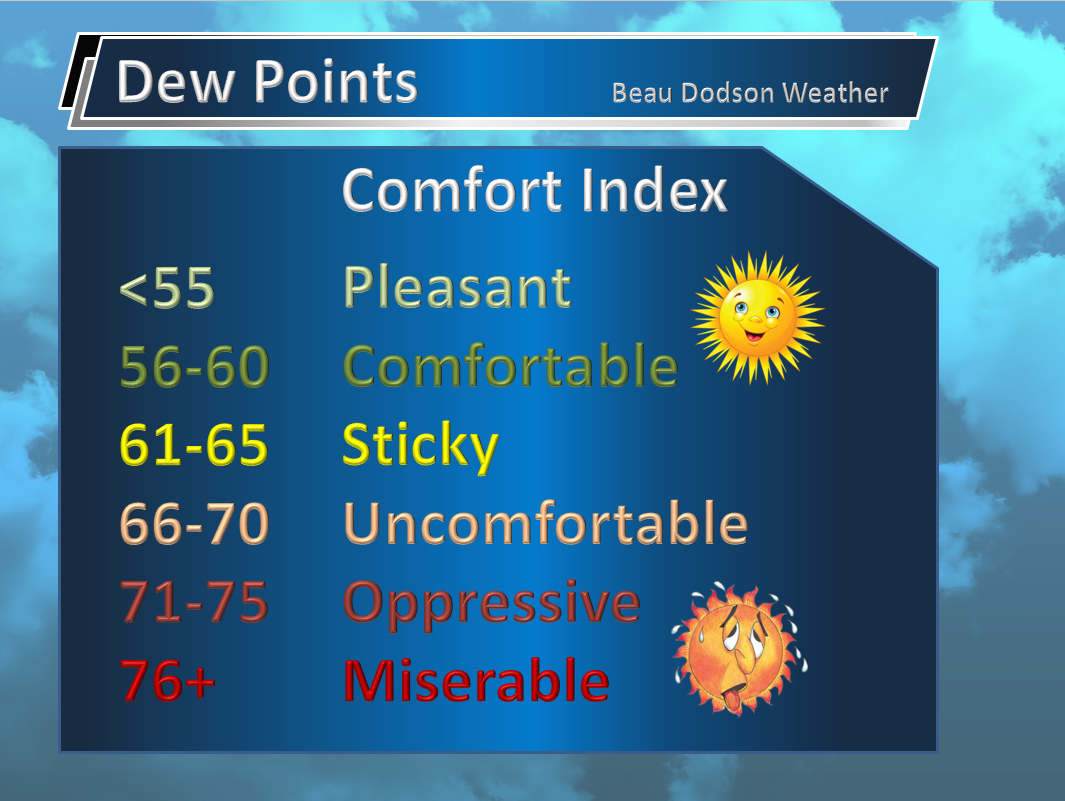
We have some unsettled weather in our future. For now, we will enjoy the nice temperatures and nice humidity levels. Dew points are much lower compared to last week. Dew point is a measure of moisture in the lower atmosphere. It is what makes you feel sticky during the summer months.
Dew points will rise back into the upper 60’s and lower 70’s by Friday and Saturday.
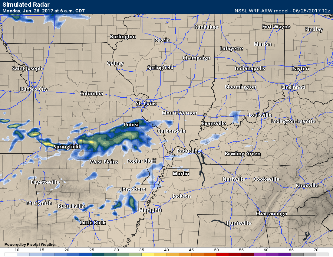
Sunday night into Monday morning should remain dry across the area. A small chance for a shower over southeast Missouri after 2 am. A few clouds are possible as we move into Monday afternoon.
Guidance wants to develop a few showers and perhaps thunderstorms over southeast Missouri during the afternoon hours. Other data keeps it dry. I did mention the possibility of a few showers or storms. If they occur it would most likely be over southeast Missouri.
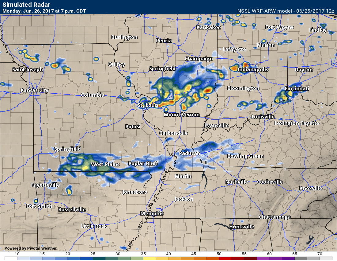
Rain chances increase on Monday night as a trough swings through the area with a weak front. Thunderstorms will be possible, as well. I am not anticipating severe weather or heavy rain. There could be a few brief downpours.
Let me show you the WRF model from the SPC. It does attempt to move some light showers into southeast Missouri late tonight. This is the 6 am future-cast radar.
There is a dry layer of air-aloft. This will likely cause the rain to evaporate.
Monday night we will have some showers and storms in the region.
This is a future-cast radar map from the WRF model. That means it is predicting rain in the region.
This is what radar MIGHT look like Monday evening. The colors represent precipitation.
Some of the models are showing drier conditions for Monday night. A band of showers and storms is anticipated, but confidence is lower than normal.
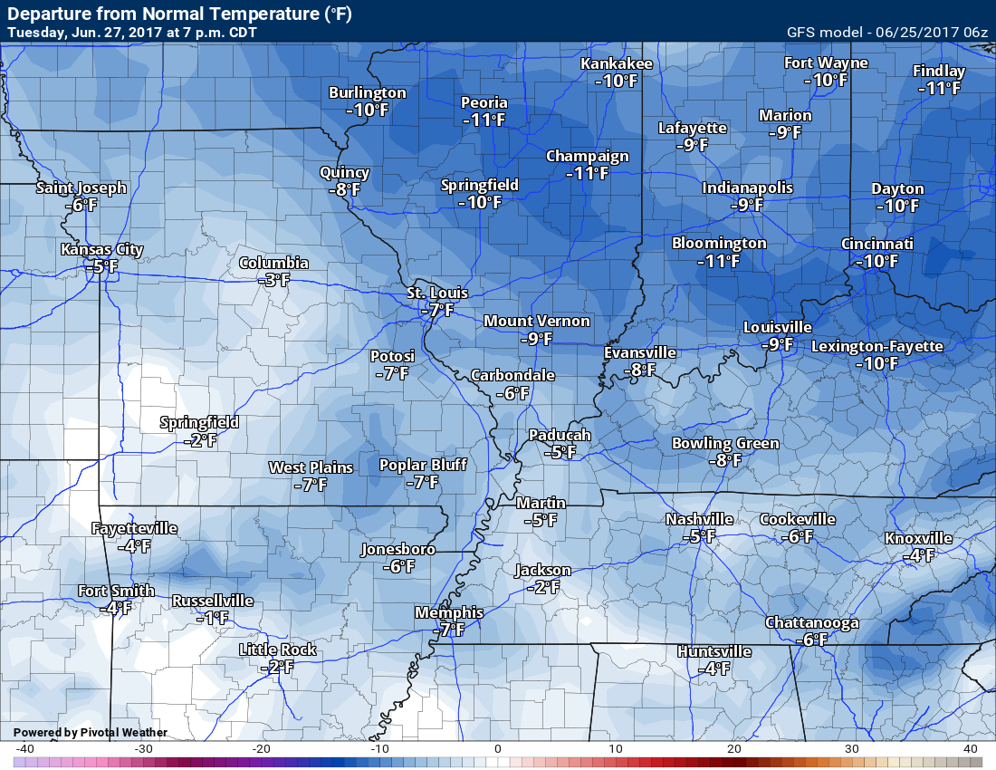
The rain should exit fairly early on Tuesday. I can’t rule out some remaining showers and storms before 8 am. That would mostly be near the Kentucky and Tennessee border and then south from there. Tuesday temperatures will be quite nice for late June. Below normal temperatures. Dew points will be in the upper 50’s to lower 60’s. It will feel nice outside. We are being spoiled!
Wednesday and Wednesday night will remain dry under high pressure.
The weather becomes more unsettled on Thursday into the weekend. A series of disturbances will push through our region. Each one of these disturbances could produce some showers and thunderstorms. The atmosphere will be more unstable on Thursday into the weekend. That means strong storms can’t be ruled out. Heavy rain can’t be ruled out.
Humidity and dew points will be on the rise by Thursday. Muggy air possible Thursday into Saturday.
We may need to monitor the potential for MCS’s. An MCS is a thunderstorm complex. They are common during the summer months. They are actually responsible for most of the rainfall between June and August.
I will be monitor the severe weather potential. To early to know if severe weather is a concern. I will keep you updated, as always.
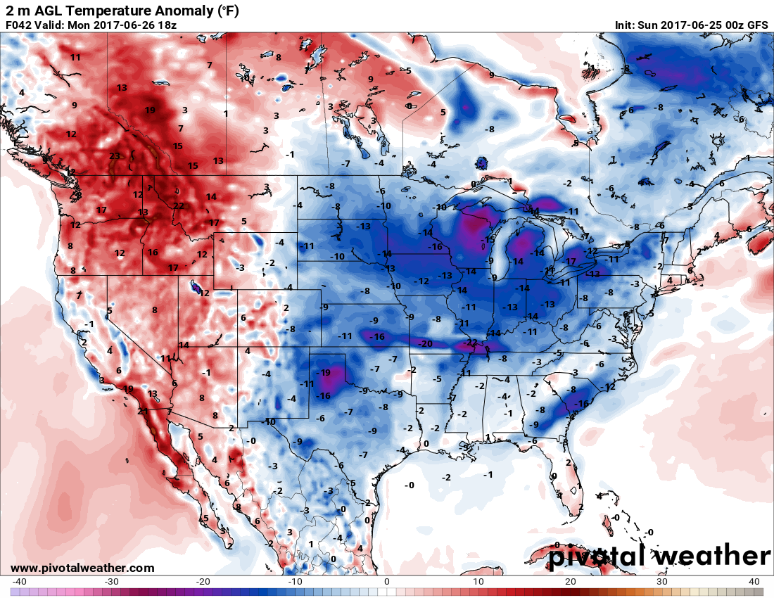
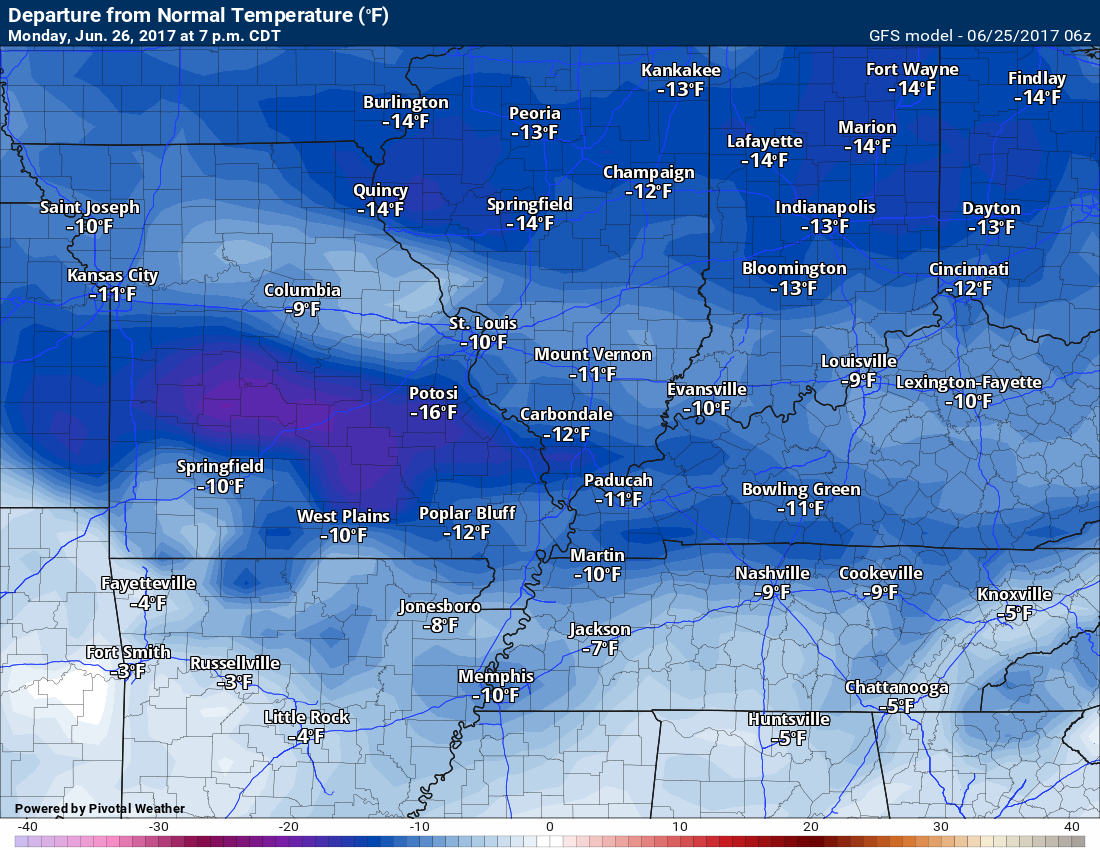
Temperatures over the coming week will average below normal, for the most part. We will warm up on Wednesday and Thursday to close to seasonal levels.
Let’s look at some temperature anomalies. Will it be below or above normal? How many degrees above or below normal?
Normal low temperatures, for this time of the year, are around 66 degrees.
Normal high temperatures, for this time of the year, are around 88 degrees.
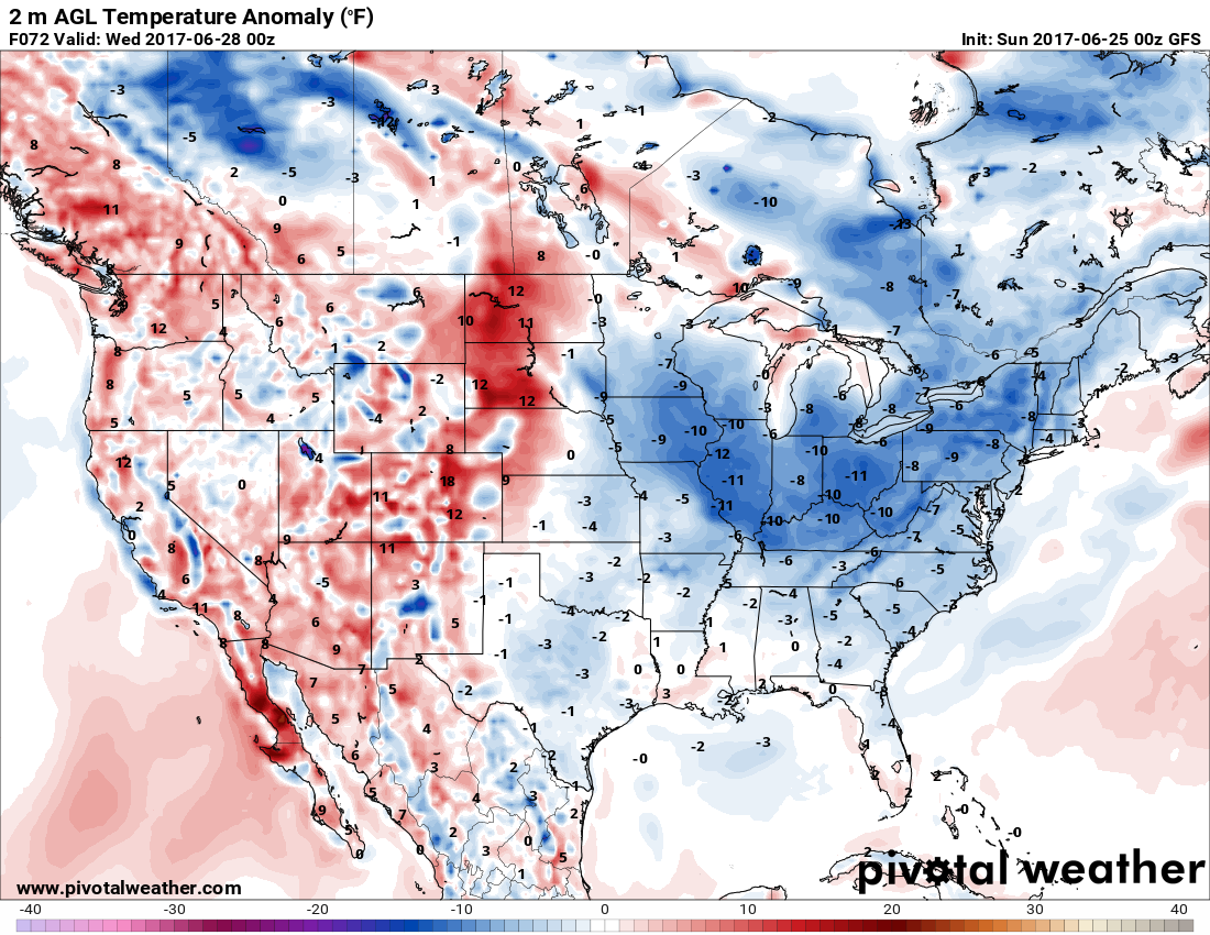
Monday afternoon
Click to enlarge the image
Tuesday evening, June 27, 2017
Large area of below normal temperatures
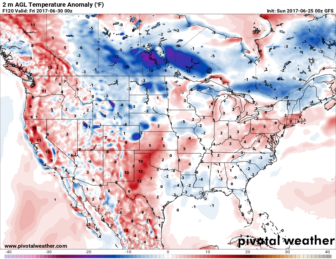
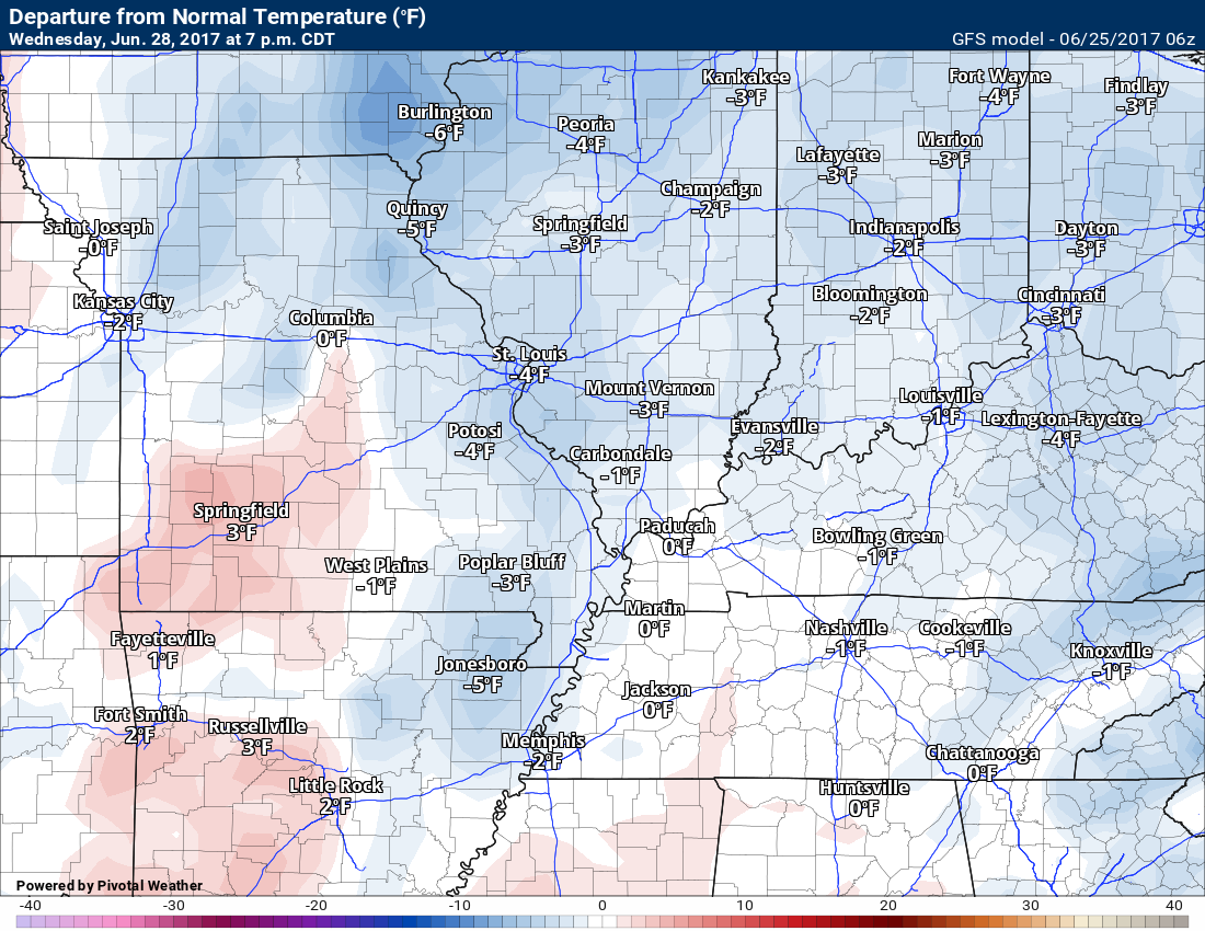
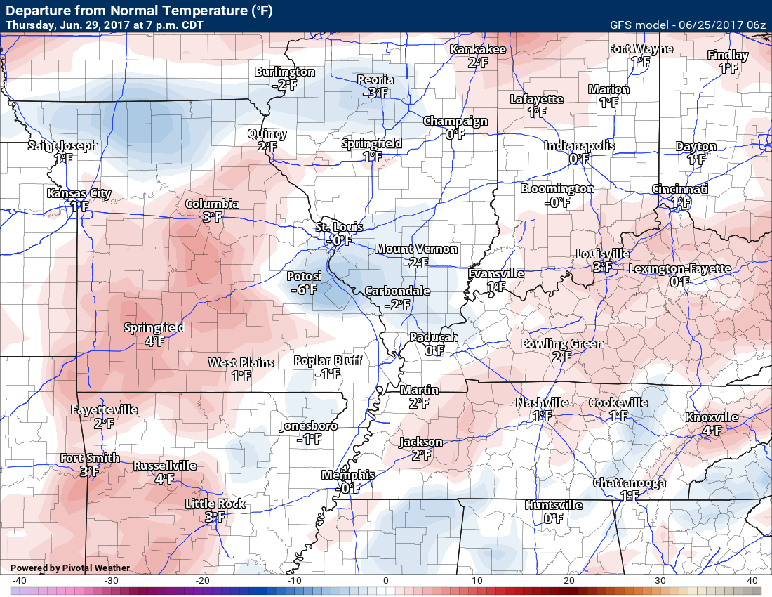
Thursday, June 30, 2017
Mixed above and below normal over the region.
Click to enlarge
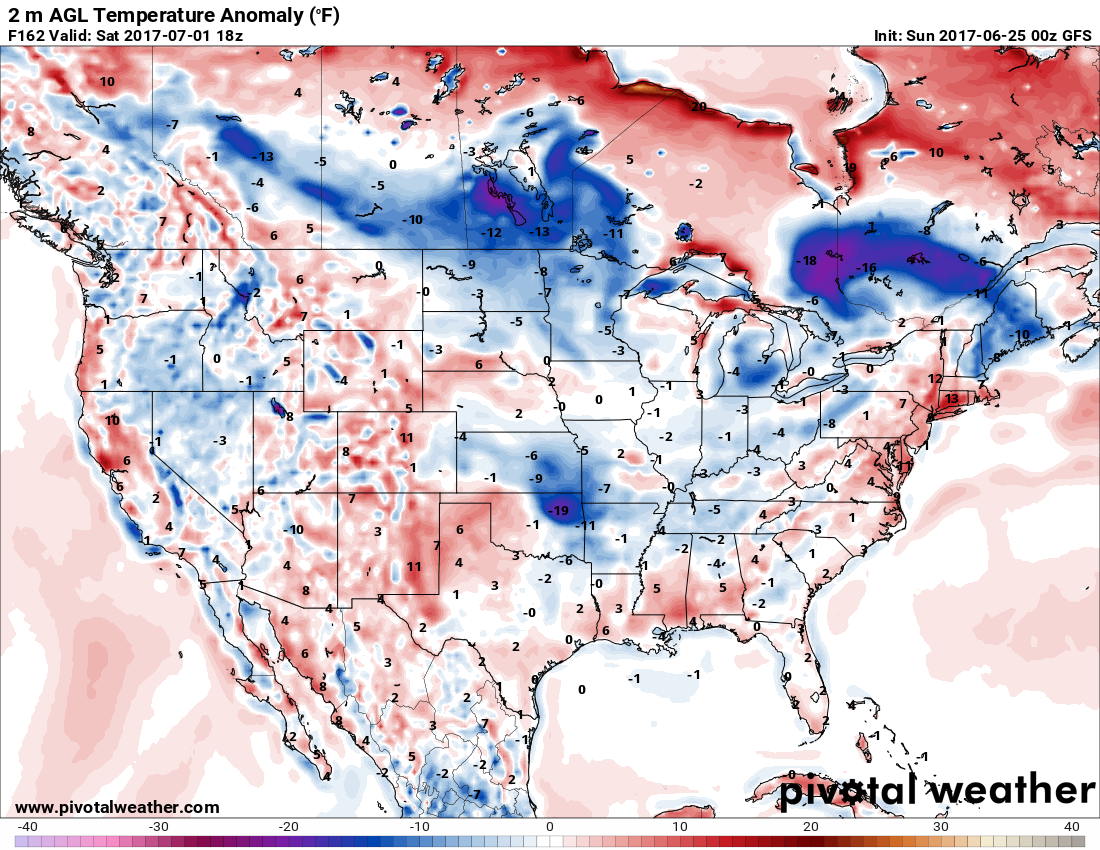
Saturday, July 1, 2017
Mixture of above and below normal temperatures.
Click to enlarge
Let’s zoom in a bit on those maps
Monday temperature anomalies. How many degrees above or below normal will temperatures be
Click images to enlarge
Tuesday
Wednesday
Thursday temperature anomalies
We start to warm up a bit by Thursday.
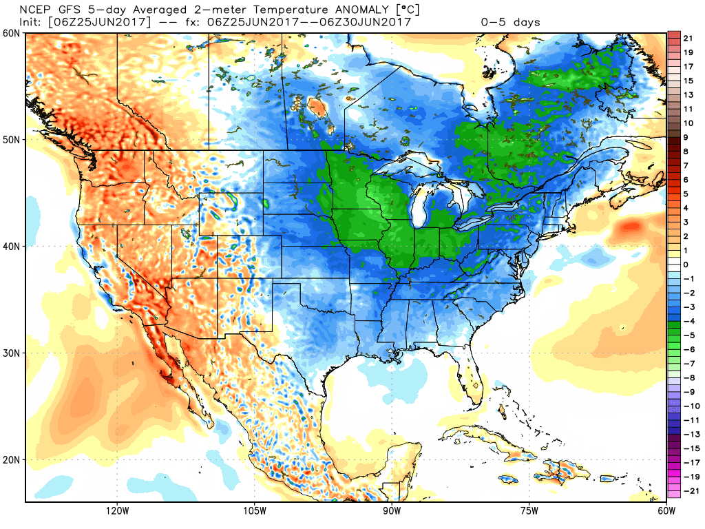
Here are the 5 day averages from Monday through Friday
Below normal temperatures blanket much of the country.
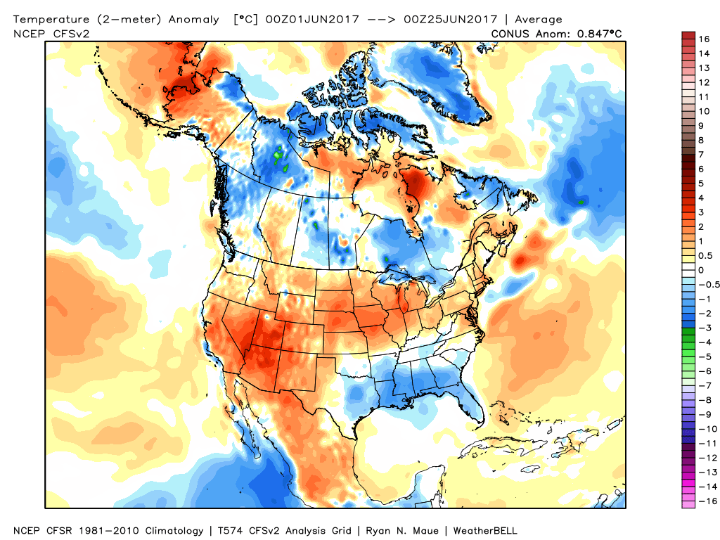
Here are the month to date averages. This is since June 1st through June 25th. Above normal temperatures in the corn belt. Below normal temperatures along the Gulf of Mexico.
This is what has already happened.

Were you aware that I have hired some help for long range videos? Short range videos, as well. An amazing team of meteorologists.
Click the link below to read more
http://cms.weathertalk.com/meet-the-team/
Weather Talk subscribers now have some of the best short and long range weather videos produced across the eastern United States.
.

Find me on Twitter
.

We have regional radars and local city radars – if a radar does not update then try another one. Occasional browsers need their cache cleared. You may also try restarting your browser. That usually fixes the problem. Occasionally we do have a radar go down. That is why I have duplicates. Thus, if one fails then try another one.
During the winter you can track snow and ice by clicking the winterize button on the local city view interactive radars.
If you have any problems then please send me an email beaudodson@usawx.com
Interactive Weather Radar Page. Choose the city nearest your location: Click this link—
National interactive radar: Click this link.
Local interactive city radars include St Louis, Mt Vernon, Evansville, Poplar Bluff, Cape Girardeau, Marion, Paducah, Hopkinsville, Memphis, Nashville, Dyersburg, and all of eastern Kentucky. These are interactive radars. Local city radars – click here
.

The official 6-10 day and 8-14 day temperature and precipitation outlook. Check the date stamp at the top of each image (so you understand the time frame).
.
The forecast maps below are issued by the Weather Prediction Center (NOAA)
.

.

.
The latest 8-14 day temperature and precipitation outlook. Note the dates are at the top of the image. These maps DO NOT tell you how high or low temperatures or precipitation will be. They simply give you the probability as to whether temperatures or precipitation will be above or below normal.
.


.
The Beau Dodson Weather APP is ready for Apple and Android users. The purpose of this app is for me to deliver your text messages instantly. ATT and Verizon have not always been reliable when it comes to speed. The app allows instant delivery.
Some of you have asked if you can keep receiving the texts on your phone and the app. The answer to that is, yes. The Android app will automatically allow that to happen. On the Apple app, however, you will need to go into your app and click settings. Make sure the green tab is OFF. Off means you will still receive the texts to your phone and the app. If you have any questions, then email me at beaudodson@usawx.com
The app is for text subscribers.
The direct download, for the Apple app, can be viewed here
https://itunes.apple.com/us/app/id1190136514
If you have not signed up for the texting service then you may do so at www.beaudodsonweather.com

The Android app is also ready.
Remember, the app’s are for www.weathertalk.com subscribers. The app allows your to receive the text messages faster than ATT and Verizon.
Here is the download link for the Android version Click Here

——————————————————–
If you have not signed up for the texts messages, then please do. Link www.beaudodsonweather.com
Your support helps with the following:

and


Who do you trust for your weather information and who holds them accountable?
I have studied weather in our region since the late 1970’s. I have 39 years of experience in observing our regions weather patterns. My degree is in Broadcast Meteorology and a Bachelor’s of Science.
My resume includes:
Member of the American Meteorological Society.
NOAA Weather-Ready Nation Ambassador.
Meteorologist for McCracken County Emergency Management. I served from 2005 through 2015.
Meteorologist for McCracken County Rescue. 2015 through current
I own and operate the Southern Illinois Weather Observatory.
I am the chief meteorologist for Weather Talk LLC. I am the owner of Weather Talk LLC.
I am also a business owner in western Kentucky.
Recipient of the Mark Trail Award, WPSD Six Who Make A Difference Award, Kentucky Colonel, and the Caesar J. Fiamma” Award from the American Red Cross.
In 2005 I helped open the largest American Cross shelter in U.S. history in Houston, Texas. I was deployed to help after Hurricane Katrina and Hurricane Rita. I was a shelter manager of one of the Houston, Texas shelter divisions.
In 2009 I was presented with the Kentucky Office of Highway Safety Award.
Recognized by the Kentucky House of Representatives for my service to the State of Kentucky leading up to several winter storms and severe weather outbreaks.
If you click on the image below you can read the Kentucky House of Representatives Resolution.

I am also President of the Shadow Angel Foundation which serves portions of western Kentucky and southern Illinois.
There is a lot of noise on the internet. A lot of weather maps are posted without explanation. Over time you should learn who to trust for your weather information.
My forecast philosophy is simple and straight forward.
- Communicate in simple terms
- To be as accurate as possible within a reasonable time frame before an event
- Interact with you on Twitter, Facebook, email, texts, and this blog
- Minimize the “hype” that you might see on some television stations or through other weather sources
- Push you towards utilizing wall-to-wall LOCAL TV coverage during severe weather events
Many of the graphics on this page are from www.weatherbell.com
WeatherBell is a great resource for weather model guidance.


You can sign up for my AWARE email by clicking here I typically send out AWARE emails before severe weather, winter storms, or other active weather situations. I do not email watches or warnings. The emails are a basic “heads up” concerning incoming weather conditions