For $3 a month you can receive the following. You may choose to receive these via your WeatherTalk app or regular text messaging.
- Severe weather app/text alerts from my keyboard to your app/cell phone. These are hand typed by Beau. During tornado outbreaks, you will receive numerous app/text messages telling you exactly where the tornado is located.
- Daily forecast app/texts from my computer to your app/cell phone.
- Social media links sent directly to your app/cell phone. When I update the blog, videos, or Facebook you will receive the link.
- AWARE emails. These emails keep you well ahead of the storm. They give you several days of lead time before significant weather events.
- Direct access to Beau via text and email. Your very own personal meteorologist. I work for you!
- Missouri and Ohio Valley centered video updates
- Long-range weather videos
- Week one, two, three and four temperature and precipitation outlooks.
- Monthly outlooks.
- Your subscription also will help support several local charities.
Haven’t you subscribed? Subscribe at www.beaudodsonweather.com

Example of a recent severe weather alert. I issued this well before the official tornado warning. You would have had plenty of time for you and your family to seek shelter.


Your $3 per month also helps support these local charity projects.

I encourage subscribers to use the app vs regular text messaging. We have found text messaging to be delayed during severe weather. The app typically will receive the messages instantly. I recommend people have three to four methods of receiving their severe weather information.
Remember, my app and text alerts are hand typed and not computer generated. You are being given personal attention during significant weather events.

WWW.WEATHERTALK.COM subscribers, here is my day to day schedule for your weather products.


We offer interactive local city live radars and regional radars. If a radar does not update then try another one. If a radar does not appear to be refreshing then hit Ctrl F5. You may also try restarting your browser.

June 22, 2018
Friday Forecast Details
Forecast: Quite a few clouds. Not as warm. Scattered thunderstorms. Some storms could produce small hail.
Temperatures: MO ~ 78 to 84 IL ~ 78 to 84 KY ~ 82 to 85 TN ~ 83 to 86
What is the chance of precipitation? MO ~ 40% to 50% IL ~ 50% to 60% KY ~ 40% to 50% TN ~ 40% to 50%
Coverage of precipitation: Scattered.
Winds: Southwest 6 to 12 mph with gusts to 20 mph
What impacts are anticipated from the weather? Wet roadways. Thunderstorms can produce torrential downpours, gusty winds, and small hail. Frequent cloud to ground lightning, as well.
My confidence in the forecast verifying: High
Is severe weather expected? Summer thunderstorms can occasionally produce pockets of high wind and hail.
The NWS defines severe weather as 58 mph wind or great, 1″ hail or larger, and/or tornadoes
Should I cancel my outdoor plans? No, but monitor radars and updated forecasts.
UV Index:6 to 9 (some uncertainty on cloud cover)
Sunrise: 5:35 AM
Friday Night Forecast Details:
Forecast: Partly to mostly cloudy. Isolated to widely scattered thunderstorms possible.
Temperatures: MO ~ 64 to 66 IL ~ 63 to 66 KY ~ 64 to 68 TN ~ 64 to 68
What is the chance of precipitation? MO ~ 20% to 30% IL ~ 20% to 30% KY ~ 20% to 30% TN ~ 20% to 30%
Coverage of precipitation: Isolated to widely scattered
Winds: West at 6 to 12 mph
What impacts are anticipated from the weather? A few wet roadways. Summer thunderstorms can produce torrential downpours, gusty winds, and small hail. Frequent cloud to ground lightning, as well.
My confidence in the forecast verifying: Medium
Is severe weather expected? Summer thunderstorms can occasionally produce pockets of high wind and hail.
The NWS defines severe weather as 58 mph wind or great, 1″ hail or larger, and/or tornadoes
Should I cancel my outdoor plans? No, but monitor radars and updated forecasts.
Sunset: 8:18 PM
Moonrise: 3:13 PM Waxing Gibbous
Moonset: 2:13 AM
June 23, 2018
Saturday Forecast Details
Forecast: Partly cloudy with an isolated thunderstorm possible.
Temperatures: MO ~ 82 to 86 IL ~ 80 to 85 KY ~ 83 to 86 TN ~ 83 to 86
What is the chance of precipitation? MO ~ 30% IL ~ 20% KY ~ 20% TN ~ 20%
Coverage of precipitation: Isolated.
Winds: West and southwest at 6 to 12 mph with gusts to 15 mph
What impacts are anticipated from the weather? Isolated scattered wet roadways. Summer thunderstorms can produce torrential downpours, gusty winds, and small hail. Frequent cloud to ground lightning, as well.
My confidence in the forecast verifying: Medium
Is severe weather expected? Summer thunderstorms can occasionally produce pockets of high winds and hail.
The NWS defines severe weather as 58 mph wind or great, 1″ hail or larger, and/or tornadoes
Should I cancel my outdoor plans? No, but monitor radars and updated forecasts.
UV Index: 7 to 9 High (depending on cloud cover)
Sunrise: 5:35 AM
Saturday Night Forecast Details:
Forecast: Partly to mostly cloudy. Scattered thunderstorms likely. Some storms will produce locally heavy rain.
Temperatures: MO ~ 66 to 70 IL ~ 66 to 70 KY ~ 66 to 70 TN ~ 66 to 70
What is the chance of precipitation? MO ~ 50% to 60% IL ~ 50% to 60% KY ~ 50% to 60% TN ~ 50% to 60%
Coverage of precipitation: Scattered to perhaps numerous.
Winds: South and southwest at 5 to 10 mph with gusts to 16 mph
What impacts are anticipated from the weather? Wet roadways. Thunderstorms can produce torrential downpours, gusty winds, and small hail. Frequent cloud to ground lightning, as well.
My confidence in the forecast verifying: Medium
Is severe weather expected? Summer thunderstorms can occasionally produce pockets of high winds and hail.
The NWS defines severe weather as 58 mph wind or great, 1″ hail or larger, and/or tornadoes
Should I cancel my outdoor plans? Have a plan B and monitor updates and radars.
Sunset: 8:19 PM
Moonrise: 4:13 PM Waxing Gibbous
Moonset: 2:45 AM
June 24, 2018
Sunday Forecast Details
Forecast: Mostly cloudy. Showers and thunderstorms likely.
Temperatures: MO ~ 84 to 88 IL ~ 84 to 88 KY ~ 84 to 88 TN ~ 84 to 88
What is the chance of precipitation? MO ~ 50% to 60% IL ~ 50% to 60% KY ~ 50% to 60% TN ~ 50% to 60%
Coverage of precipitation: Scattered to perhaps numerous
Winds: West and southwest at 6 to 12 mph with gusts to 20.
What impacts are anticipated from the weather? Wet roadways. Thunderstorms can produce torrential downpours, gusty winds, and small hail. Frequent cloud to ground lightning, as well.
My confidence in the forecast verifying: Medium
Is severe weather expected? Summer thunderstorms can occasionally produce pockets of high winds and hail.
The NWS defines severe weather as 58 mph wind or great, 1″ hail or larger, and/or tornadoes
Should I cancel my outdoor plans? Monitor radars and updated forecasts.
UV Index: 4 to 8 (depending on cloud cover)
Sunrise: 5:35 AM
Sunday Night Forecast Details:
Forecast: Mostly cloudy. Isolated thunderstorms possible.
Temperatures: MO ~ 68 to 72 IL ~ 68 to 72 KY ~ 68 to 72 TN ~ 68 to 72
What is the chance of precipitation? MO ~ 30% IL ~ 30% KY ~ 30% TN ~ 30%
Coverage of precipitation: Isolated
Winds: North and northeast at 5 to 10 mph with gusts to 18 mph
What impacts are anticipated from the weather? Isolated wet roadways. Summer thunderstorms can produce torrential downpours, gusty winds, and small hail. Frequent cloud to ground lightning, as well.
My confidence in the forecast verifying: Medium
Is severe weather expected? Summer thunderstorms can occasionally produce pockets of high winds and hail.
The NWS defines severe weather as 58 mph wind or great, 1″ hail or larger, and/or tornadoes
Should I cancel my outdoor plans? Monitor radars and updated forecasts.
Sunset: 8:19 PM
Moonrise: 5:11 PM Waxing Gibbous
Moonset: 3:18 AM
June 25, 2018
Monday Forecast Details
Forecast: A mix of sun and clouds. A chance for showers and thunderstorms. Warm.
Temperatures: MO ~ 86 to 90 IL ~ 84 to 88 KY ~ 84 to 88 TN ~ 85 to 88
What is the chance of precipitation? MO ~ 30% IL ~ 40% KY ~ 40% TN ~ 30%
Coverage of precipitation: Scattered
Winds: South and southwest at 7 to 14 mph with gusts to 18
What impacts are anticipated from the weather? Wet roadways. Summer thunderstorms can produce torrential downpours, gusty winds, and small hail. Frequent cloud to ground lightning, as well.
My confidence in the forecast verifying: High
Is severe weather expected? Summer thunderstorms can occasionally produce pockets of high winds and hail.
The NWS defines severe weather as 58 mph wind or great, 1″ hail or larger, and/or tornadoes
Should I cancel my outdoor plans? No, but check radars
UV Index: 9 to 10 Very high
Sunrise: 5:36 AM
Monday Night Forecast Details:
Forecast: Partly cloudy. Mild. A chance for scattered thunderstorms.
Temperatures: MO ~ 68 to 74 IL ~ 68 to 74 KY ~ 68 to 74 TN ~ 68 to 74
What is the chance of precipitation? MO ~ 40% IL ~ 30% KY ~ 30% TN ~ 30%
Coverage of precipitation: Scattered
Winds: South and southeast at 5 to 10 mph
What impacts are anticipated from the weather? Wet roadways. Summer thunderstorms can produce torrential downpours, gusty winds, and small hail. Frequent cloud to ground lightning, as well.
My confidence in the forecast verifying: Medium
Is severe weather expected? Summer thunderstorms can occasionally produce pockets of high winds and hail.
The NWS defines severe weather as 58 mph wind or great, 1″ hail or larger, and/or tornadoes
Should I cancel my outdoor plans? No, but check radars
Sunset: 8:19 PM
Moonrise: 6:09 PM Waxing Gibbous
Moonset: 3:54 AM
June 26, 2018
Tuesday Forecast Details
Forecast: Partly cloudy and hot. Humid. Scattered thunderstorms again possible. Heat index above 100 degrees.
Temperatures: MO ~ 90 to 94 IL ~ 88 to 94 KY ~ 88 to 94 TN ~ 88 to 94
What is the chance of precipitation? MO ~ 40% IL ~ 40% KY ~ 40% TN ~ 40%
Coverage of precipitation: Scattered
Winds: Southwest at 8 to 16 mph
What impacts are anticipated from the weather? Summer thunderstorms can produce torrential downpours, gusty winds, and small hail. Frequent cloud to ground lightning, as well.
My confidence in the forecast verifying: Medium
Is severe weather expected? Summer thunderstorms can occasionally produce pockets of high winds and hail.
The NWS defines severe weather as 58 mph wind or great, 1″ hail or larger, and/or tornadoes
Should I cancel my outdoor plans? No, but check radars
UV Index: 9 to 10 Very high
Sunrise: 5:36 AM
Tuesday Night Forecast Details:
Forecast: Partly cloudy. Warm and humid. Isolated storms possible.
Temperatures: MO ~ 70 to 75 IL ~ 70 to 75 KY ~ 70 to 75 TN ~ 70 to 75
What is the chance of precipitation? MO ~ 20% IL ~ 20% KY ~ 20% TN ~ 20%
Coverage of precipitation: Isolated
Winds: South and southwest 5 to 10 mph
What impacts are anticipated from the weather? Isolated wet roadways. Summer thunderstorms can produce torrential downpours, gusty winds, and small hail. Frequent cloud to ground lightning, as well.
My confidence in the forecast verifying: Medium
Is severe weather expected? Summer thunderstorms can occasionally produce pockets of high winds and hail.
The NWS defines severe weather as 58 mph wind or great, 1″ hail or larger, and/or tornadoes
Should I cancel my outdoor plans? No, but check radars
Sunset: 8:19PM
Moonrise: 7:04 PM Waxing Gibbous
Moonset: 4:33 AM
June 27, 2018
Wednesday Forecast Details
Forecast: Partly cloudy and hot. Humid. Isolated thunderstorms possible. Heat index above 100 degrees.
Temperatures: MO ~ 90 to 95 IL ~ 90 to 95 KY ~ 90 to 95 TN ~ 90 to 95
What is the chance of precipitation? MO ~ 20% IL ~ 30% KY ~ 30% TN ~ 30%
Coverage of precipitation: Isolated
Winds: Southwest 7 to 14 mph with higher gusts
What impacts are anticipated from the weather? Summer thunderstorms can produce torrential downpours, gusty winds, and small hail. Frequent cloud to ground lightning, as well.
My confidence in the forecast verifying: Medium
Is severe weather expected? Summer thunderstorms can occasionally produce pockets of high winds and hail.
The NWS defines severe weather as 58 mph wind or great, 1″ hail or larger, and/or tornadoes
Should I cancel my outdoor plans? No, but check radars
UV Index: 9 to 10 Very high
Sunrise: 5:36 AM
Wednesday Night Forecast Details:
Forecast: Partly cloudy. Mild. Isolated thunderstorms possible.
Temperatures: MO ~ 70 to 75 IL ~ 70 to 75 KY ~ 70 to 75 TN ~ 70 to 75
What is the chance of precipitation? MO ~ 20% IL ~ 20% KY ~ 20% TN ~ 20%
Coverage of precipitation: Isolated
Winds: South and southwest at 7 to 14 mph
What impacts are anticipated from the weather? Isolated wet roadways. Summer thunderstorms can produce torrential downpours, gusty winds, and small hail. Frequent cloud to ground lightning, as well.
My confidence in the forecast verifying: Medium
Is severe weather expected? Summer thunderstorms can occasionally produce pockets of high winds and hail.
The NWS defines severe weather as 58 mph wind or great, 1″ hail or larger, and/or tornadoes
Should I cancel my outdoor plans? No, but check radars
Sunset: 8:19 PM
Moonrise: 7:57 PM Waxing Gibbous
Moonset: 5:15 AM
June 28, 2018
Thursday Forecast Details
Forecast: Mostly sunny. Hot and muggy. Heat index above 100 degrees.
Temperatures: MO ~ 90 to 95 IL ~ 90 to 95 KY ~ 90 to 95 TN ~ 90 to 95
What is the chance of precipitation? MO ~ 20% IL ~ 20% KY ~ 20% TN ~ 20%
Coverage of precipitation: None to isolated
Winds: Southwest 7 to 14 mph and gusty
What impacts are anticipated from the weather? Most likely none
My confidence in the forecast verifying: High
Is severe weather expected? No
The NWS defines severe weather as 58 mph wind or great, 1″ hail or larger, and/or tornadoes
Should I cancel my outdoor plans? No
UV Index: 9 to 10 Very high
Sunrise: 5:36 AM
Thursday Night Forecast Details:
Forecast: Mostly clear. Warm and humid.
Temperatures: MO ~ 72 to 76 IL ~ 72 to 76 KY ~ 72 to 76 TN ~ 72 to 76
What is the chance of precipitation? MO ~ 20% IL ~ 20% KY ~ 20% TN ~ 20%
Coverage of precipitation: None to isolated
Winds: South and southwest at 7 to 14 mph with gusts to 18
What impacts are anticipated from the weather? Most likely none.
My confidence in the forecast verifying: High
Is severe weather expected? Summer thunderstorms can occasionally produce pockets of high winds and hail.
The NWS defines severe weather as 58 mph wind or great, 1″ hail or larger, and/or tornadoes
Should I cancel my outdoor plans? No
Sunset: 8:19PM
Moonrise: 8:45 PM Full
Moonset: 6:02 AM
June 29, 2018
Friday Forecast Details
Forecast: Mostly sunny. Hot and humid. Heat index above 100.
Temperatures: MO ~ 92 to 96 IL ~ 92 to 96 KY ~ 92 to 96 TN ~ 92 to 96
What is the chance of precipitation? MO ~ 20% IL ~ 20% KY ~ 20% TN ~ 20%
Coverage of precipitation: None to isolated
Winds: Southwest 7 to 14 mph with gusts to 18 mph
What impacts are anticipated from the weather? Summer thunderstorms can produce torrential downpours, gusty winds, and small hail. Frequent cloud to ground lightning, as well.
My confidence in the forecast verifying: Medium
Is severe weather expected? Summer thunderstorms can occasionally produce pockets of high winds and hail.
The NWS defines severe weather as 58 mph wind or great, 1″ hail or larger, and/or tornadoes
Should I cancel my outdoor plans? No
UV Index: 9 to 10 Very high
Sunrise: 5:37 AM
Friday Night Forecast Details:
Forecast: Mostly clear. Warm and muggy.
Temperatures: MO ~ 72 to 76 IL ~ 72 to 76 KY ~ 72 to 76 TN ~ 72 to 76
What is the chance of precipitation? MO ~ 20% IL ~ 20% KY ~ 20% TN ~ 20%
Coverage of precipitation: None to isolated
Winds: South and southwest at 7 to 14 mph
What impacts are anticipated from the weather? Most likely none.
My confidence in the forecast verifying: Medium
Is severe weather expected? Summer thunderstorms can occasionally produce pockets of high winds and hail.
The NWS defines severe weather as 58 mph wind or great, 1″ hail or larger, and/or tornadoes
Should I cancel my outdoor plans? No
Sunset: 8:19 PM
Moonrise: 9:30 PM Waning Gibbous
Moonset: 6:51 AM
June 30, 2018
Saturday Forecast Details
Forecast: Partly cloudy and hot. Humid. Isolated thunderstorms possible.
Temperatures: MO ~ 92 to 96 IL ~ 92 to 96 KY ~ 92 to 96 TN ~ 92 to 96
What is the chance of precipitation? MO ~ 20% IL ~ 20% KY ~ 20% TN ~ 20%
Coverage of precipitation: None to isolated
Winds: South and southwest at 7 to 14 mph with gusts to 18
What impacts are anticipated from the weather? Summer thunderstorms can produce torrential downpours, gusty winds, and small hail. Frequent cloud to ground lightning, as well.
My confidence in the forecast verifying: Medium
Is severe weather expected? Summer thunderstorms can occasionally produce pockets of high winds and hail.
The NWS defines severe weather as 58 mph wind or great, 1″ hail or larger, and/or tornadoes
Should I cancel my outdoor plans? No
UV Index: 9 to 10 Very high
Sunrise: 5:37 AM
Saturday Night Forecast Details:
Forecast: Mostly clear. Warm and muggy.
Temperatures: MO ~ 72 to 76 IL ~ 72 to 76 KY ~ 72 to 76 TN ~ 72 to 76
What is the chance of precipitation? MO ~ 20% IL ~ 20% KY ~ 20% TN ~ 20%
Coverage of precipitation: None to isolated
Winds: South and southwest at 7 to 14 mph
What impacts are anticipated from the weather? Isolated wet roadways. Summer thunderstorms can produce torrential downpours, gusty winds, and small hail. Frequent cloud to ground lightning, as well.
My confidence in the forecast verifying: Medium
Is severe weather expected? Summer thunderstorms can occasionally produce pockets of high winds and hail.
The NWS defines severe weather as 58 mph wind or great, 1″ hail or larger, and/or tornadoes
Should I cancel my outdoor plans? No
Sunset: 8:19 PM
Moonrise: 10:10 PM Waning Gibbous
Moonset: 7:44 AM
Learn more about the UV index readings. Click here.

We will have on and off shower and thunderstorm chances into the weekend.
Heavy rain will occur where thunderstorms form. Pockets of flash flooding possible.
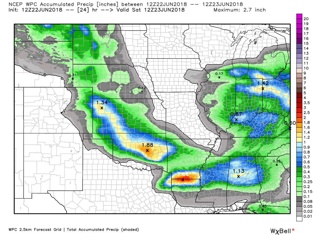
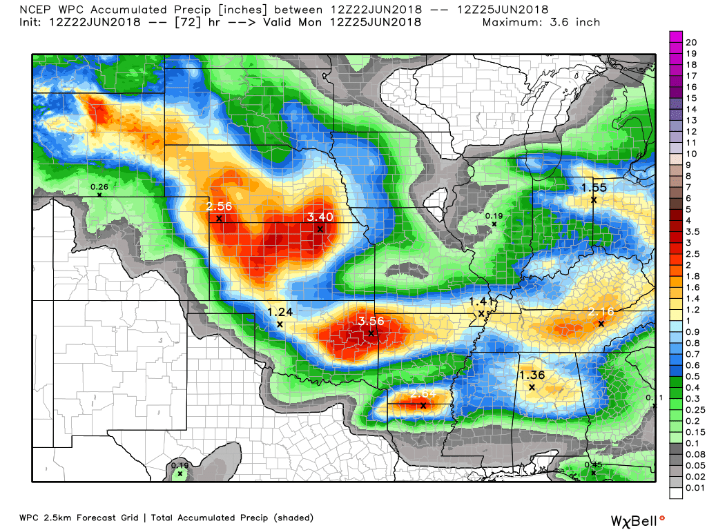
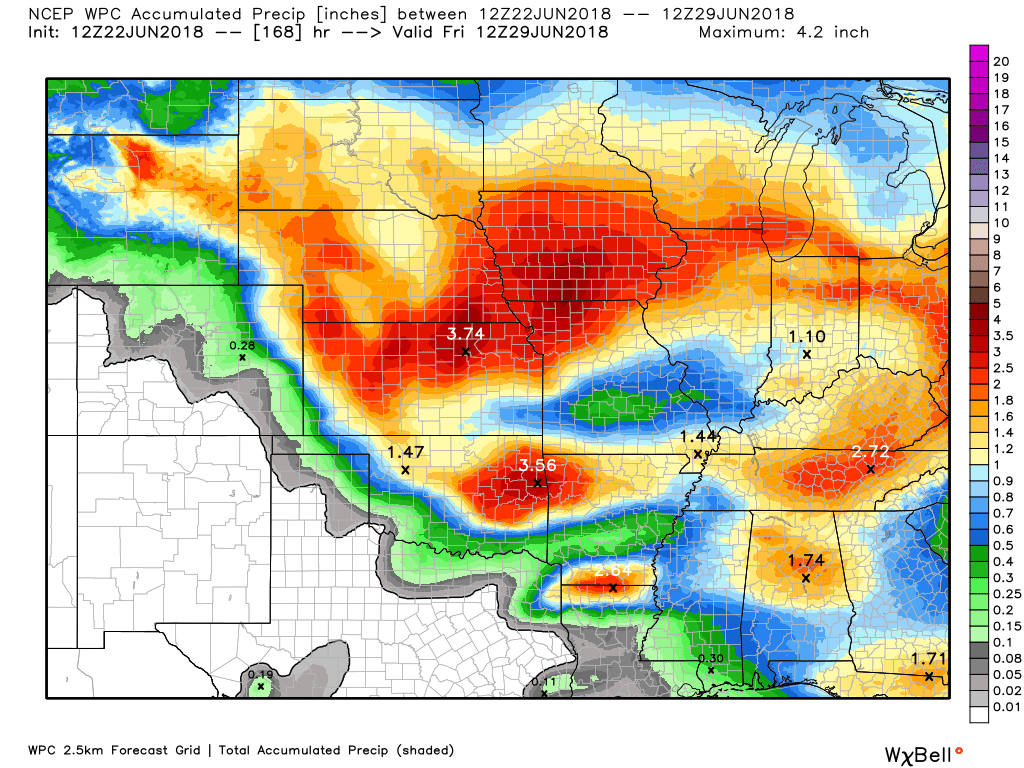
Here is the latest WPC / NOAA
A WIDE range of rainfall totals (even within the same county).
This graphic will not cover those wild swings in rainfall totals that occur from locally heavy thunderstorms.
Here is the 24 hour WPC rainfall forecast
72 hour rainfall forecast
7 day rainfall totals (all seven days added together)
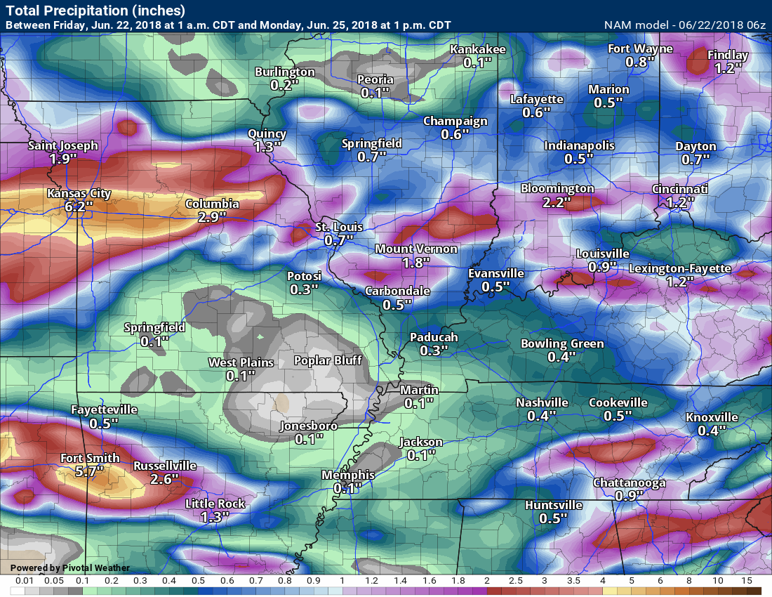
This next graphic is the NAM model guidance rainfall forecast
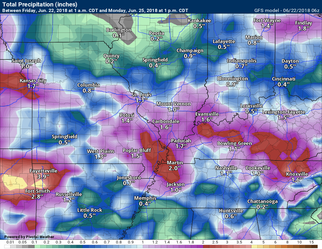
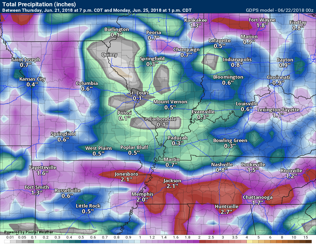
Click images to enlarge
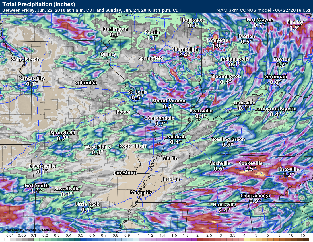
The NAM model
This next graphic is the GFS
This next graphic is the GEM model rainfall
.

We offer interactive local city live radars and regional radars. If a radar does not update then try another one.
If a radar does not appear to be refreshing then hit Ctrl F5 on your keyboard.
You may also try restarting your browser.
The local city view radars also have clickable warnings.
During the winter months, you can track snow and ice by clicking the winterize button on the local city view interactive radars.

Questions? Broken links? Other questions?
You may email me at beaudodson@usawx.com

The National Weather Service defines a severe thunderstorm as one that produces quarter size hail or larger, 58 mph winds or greater, and/or a tornado.
Friday through Sunday: Thunderstorms are possible into Sunday. Some of the storms will again produce heavy rain, gusty wind, and nickel size hail.
I will be monitoring for an MCS Saturday night and Sunday. An MCS is a large complex of thunderstorms. These can occasionally produce severe weather. It is possible that it stays to our southwest. Monitor updates.
There will also be a risk of downburst winds. Downburst winds can exceed 50 mph.
What are downbursts?

Interactive live weather radar page. Choose the city nearest your location. If one of the cities does not work then try a nearby one. Click here.
National map of weather watches and warnings. Click here.
Storm Prediction Center. Click here.
Weather Prediction Center. Click here.

Live lightning data: Click here.

Interactive GOES R satellite. Track clouds. Click here.

Here are the latest local river stage forecast numbers Click Here.
Here are the latest lake stage forecast numbers for Kentucky Lake and Lake Barkley Click Here.

The spring and preliminary summer outlooks have been posted for subscribers. Scroll down to see the outlook.Not a subscriber? Learn more at this link.

Weather Headlines
- A few showers and thunderstorms over the coming days.
- Locally heavy rain will continue to be a concern.
- Cold air funnels possible today.
- A few storms could produce high winds.
- Hot temperatures return Monday and Tuesday with highs back into the 90’s.
Well, Thursday was an active weather day. We had numerous reports of high winds and at least one tornado. The tornado was in Stoddard and New Madrid Counties. The tornado was on the ground for awhile. We will see if the NWS does a storm survey on it.
Numerous photos and videos of the tornado were posted on social media.
Here is one photo from Charlie Thacker. This was north of Palma, Missouri.
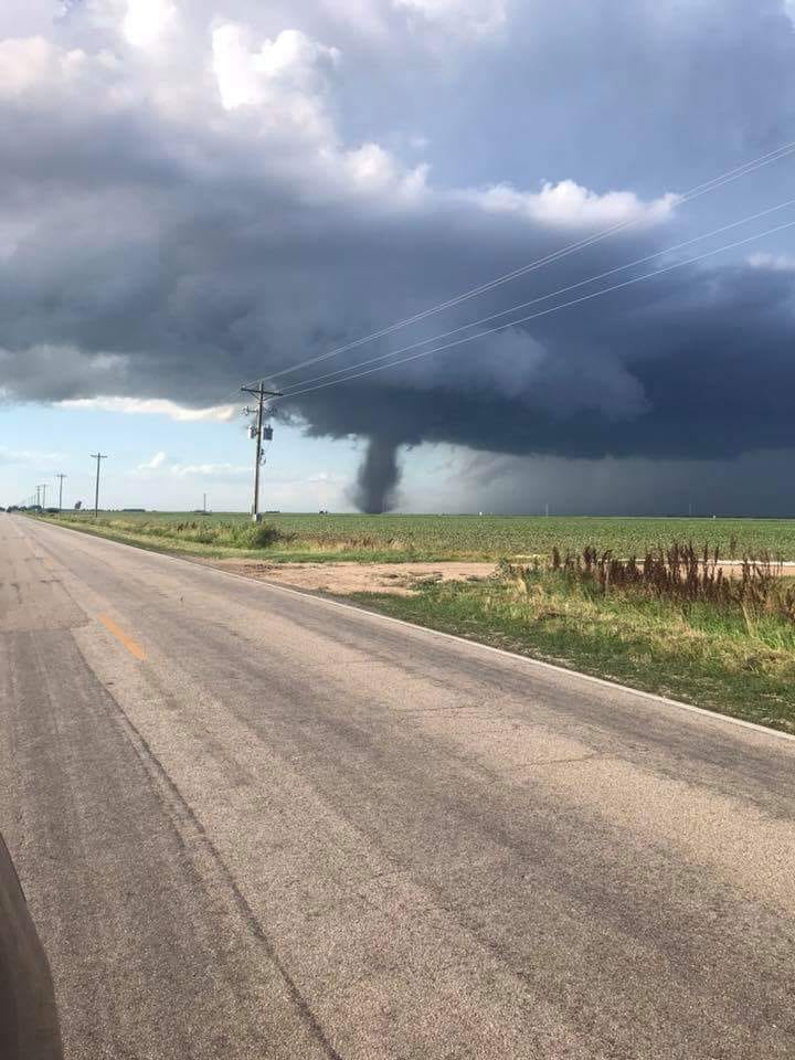
Thankfully, the tornado was mostly in rural areas.
We will have additional thunderstorm chances today into Sunday.
Any storms that form could produce locally heavy rain, small hail, and gusty winds. A few cold air funnels will be possible.
What is a cold air funnel?
This is from Haby Hints.
A cold air funnel is a high based weak circulation that occurs in a cool air mass. By high based it is meant it develops well above the earth’s surface. Since it is high based and weak they rarely impact the earth’s surface although they can look threatening. Unlike typical tornadoes, cold air funnels develop in a shallow cool air mass and often behind a cold frontal passage. The mixing of cool and windy conditions in the lower troposphere with air in the middle troposphere flowing in a different direction may spark the rotation that spins up the funnel. If the air is moist enough and rises enough the condensation funnel will be visible. The image below gives an idea to what these cold air funnels look like.
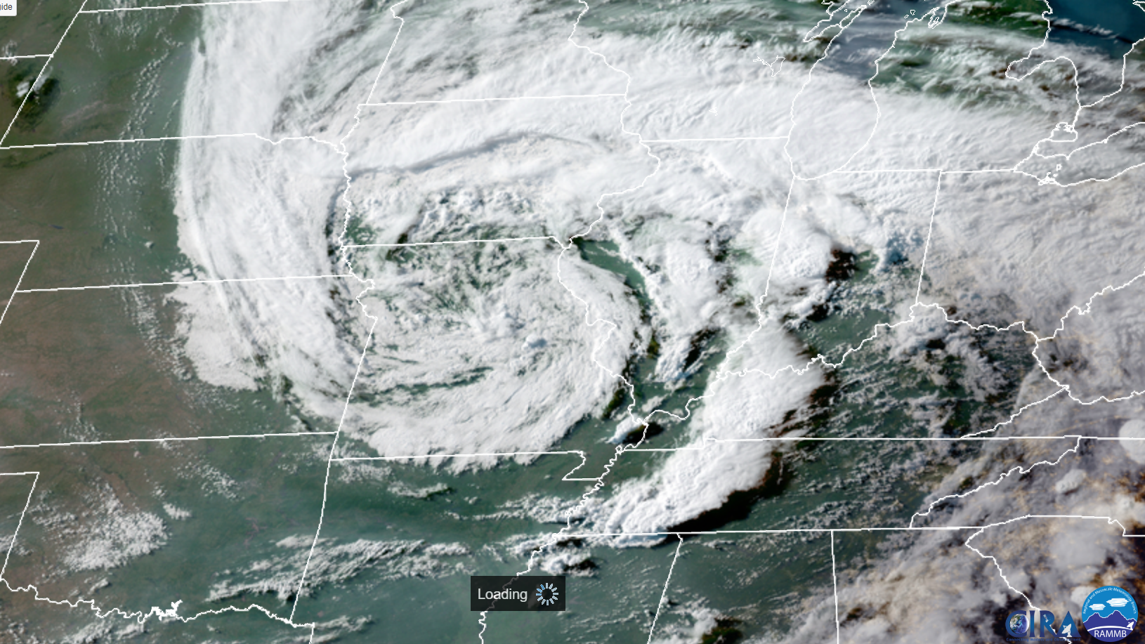
We will have the upper level low over our region today.
Check out this satellite photo from last night. That big spiral is the upper level low. Remember, low pressure rotates counter-clockwise.
There are some questions about rain coverage over the coming days. Many areas will see spotty showers and thunderstorms today into this evening. Activity will wane tonight.
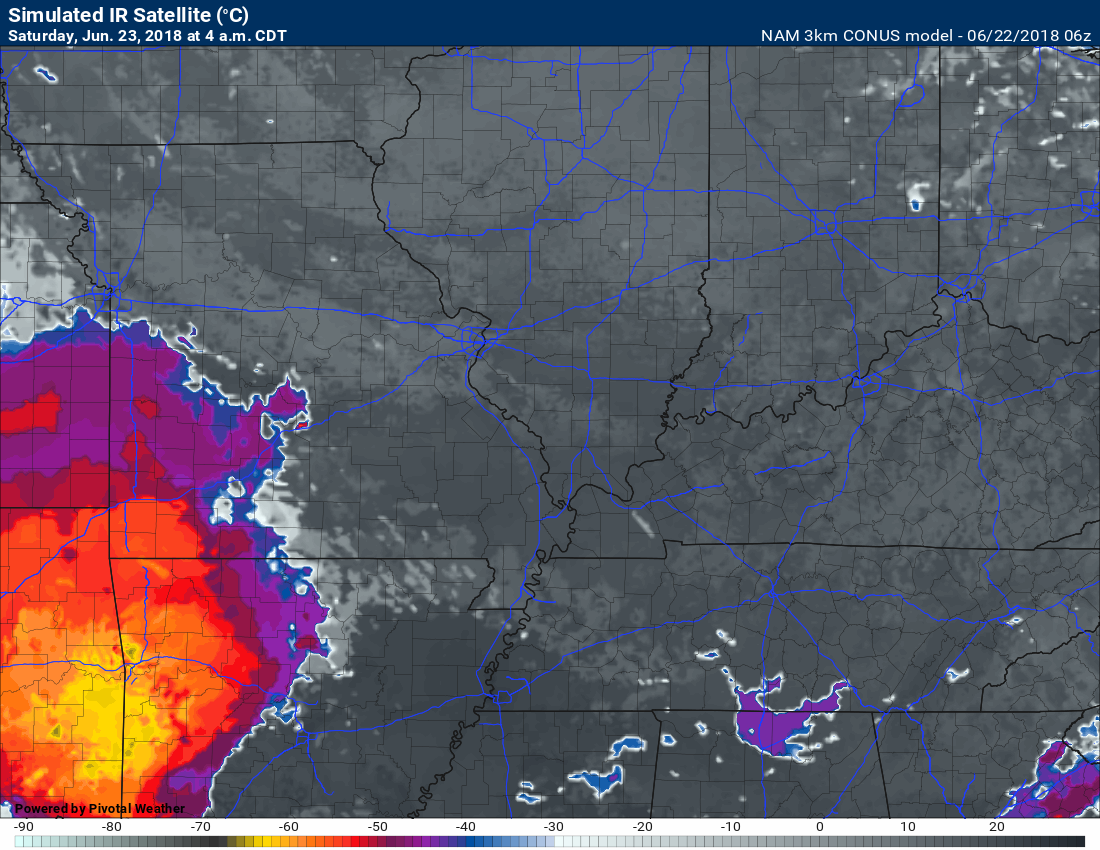
A complex of thunderstorms will develop late tonight to our southwest. At this time, it appears that system will remain south of our area. That leaves rain chances tonight in the 10% to 20% range.
Temperatures tonight will mostly in the 60’s. Some areas will be near 70 degrees.
Here is the future-cast satellite for tonight. That large area of bright colors represents the MCS. You are looking at infrared satellite (future-cast)
This should stay to our southwest.
Saturday and Saturday night
For the most part, rain chances on Saturday should be on the low side. We are looking at 10% to 30% probabilities. The greatest chance would be over southeast Missouri and perhaps northwest Tennessee. Lesser chances as you move north and northeast.
All in all, Saturday should be an okay day for most of us.
The forecast becomes interesting Saturday night as a potential MCS develops to our west. An MCS is a large complex of thunderstorms. They are typical during the summer months and produce much of our summer rainfall in the corn belt areas.
The track of this MCS is questionable.
At this time, it appears the best chance of showers and locally heavy thunderstorms will be across the southern half of the region. That would be from Poplar Bluff, MO towards Cape Girardeau, Missouri and then towards Madisonville, Kentucky. Monitor updates. The track could shift around.
Thunderstorms Saturday night will produce locally heavy rain, gusty winds, lightning, and small hail. I can’t rule out severe weather. Confidence in the severe weather part of the forecast is low.
Here is the future-cast infrared satellite image of the Saturday night storms. The NAM model shows it, but not as strong as the Friday night event. One model’s opinion.
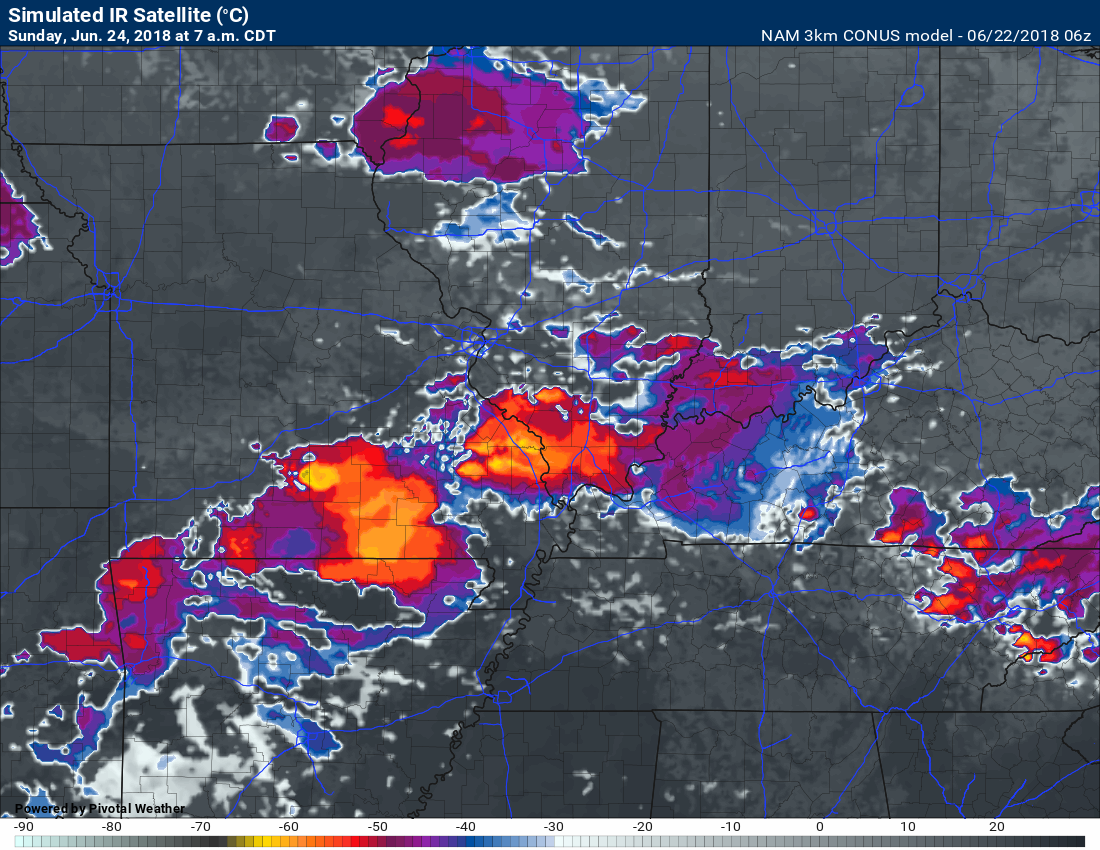
Sunday morning we may still be dealing with the left overs of the MCS. Showers and thunderstorms will be in the forecast Sunday and Sunday afternoon. Coverage is questionable.
If you have outdoor plans Saturday then you should be okay. Monitor radars.
I would monitor updated forecast numbers Sunday morning into Sunday afternoon.
Hot weather returns Monday into Wednesday with high temperatures bouncing back into the 90 to 95 degree range. Heat index values will also be on the rise. It will begin to feel uncomfortable.
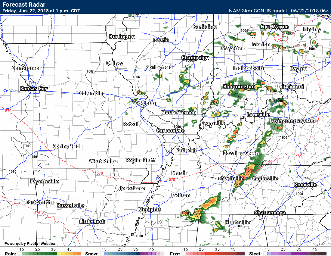
Let’s look at the NAM model future-cast radars. This certainly won’t be exact. Model’s don’t handle MCS’s all that well. Take the general idea from these loops. We will have some precipitation chances over the coming days.
Timestamp upper left.
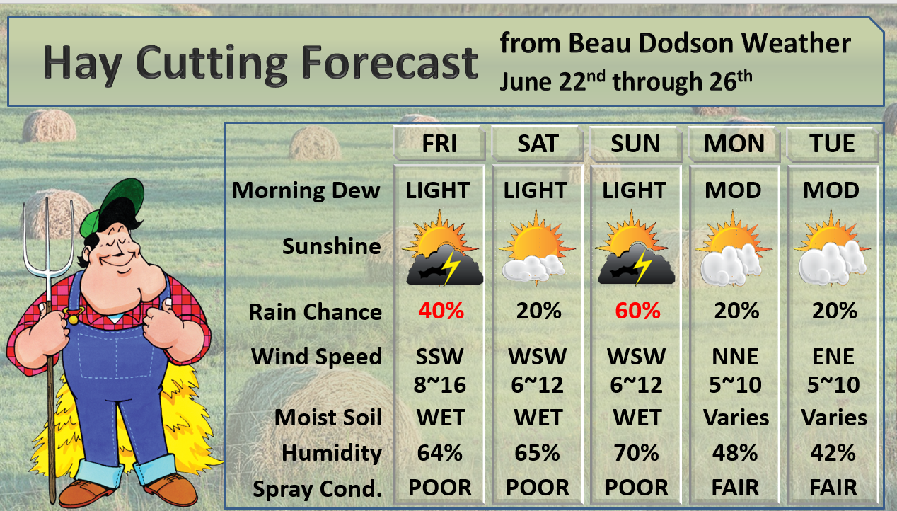
The hay cutting forecast continues to show some wet potential.
![]()
The preliminary July forecast has been updated. The heat will likely be the big story.
These graphics are for subscribers.
Subscribe at www.weathertalk.com
![]()
These are bonus videos and maps for subscribers.
I bring these to you from the BAMwx team. I pay them to help with videos. They have a great team of meteorologists. The Ohio and Missouri Valley videos cover most of our area. They do not have a specific Tennessee Valley forecast but may add one in the future.
The long-range video is technical. Over time, you can learn a lot about meteorology from the long range video. Just keep in mind, it is a bit more technical.
NOTE: THESE ARE USUALLY NOT UPDATED ON SATURDAY OR SUNDAY.

These graphics are for subscribers.
Subscribe at www.weathertalk.com
Illinois/Ohio Valley

These graphics are for subscribers.
Subscribe at www.weathertalk.com
Missouri Valley and Central Plains

These graphics are for subscribers.
Subscribe at www.weathertalk.com
Long Range

I bring these to you from the BAMwx team. They are excellent long-range forecasters.
Remember, long-range outlooks are a bit of skill, understanding weather patterns, and luck combined. It is not an exact science.

Outlook definitions
EQ = Equal chances of above or below normal
BN= Below normal
M/BN = Much below normal
AN = Above normal
M/AN = Much above normal
E/AN = Extremely above normal.
Normal high temperatures for this time of the year are around 88 degrees.
Normal low temperatures for this time of the year are around 65 degrees.
Normal precipitation during this time period ranges from 0.60″ to 0.80″
This outlook covers June 12th through June 18th
These graphics are for subscribers.
Subscribe at www.weathertalk.com

These graphics are for subscribers.
The precipitation forecast is PERCENT OF NORMAL. For example, if your normal rainfall is 1.00″ and the graphic shows 10%, then that would mean 0.10″ of rain is anticipated.
These graphics are for subscribers.
Subscribe at www.weathertalk.com

This outlook covers June 22nd through July 5th
These graphics are for subscribers.
Subscribe at www.weathertalk.com
And precipitation
These graphics are for subscribers.
Subscribe at www.weathertalk.com
June temperature and precipitation outlook
These graphics are for subscribers.
Subscribe at www.weathertalk.com

Outlook definitions
EQ = Equal chances of above or below normal
BN= Below normal
M/BN = Much below normal
AN = Above normal
M/AN = Much above normal
E/AN = Extremely above normal.
Temperature outlook for April through June.
These graphics are for subscribers.
Subscribe at www.weathertalk.com
Precipitation outlook for March through May.
These graphics are for subscribers.
Subscribe at www.weathertalk.com
Temperature outlook for June through August.
These graphics are for subscribers.
Subscribe at www.weathertalk.com
July temperature and precipitation outlook
These graphics are for subscribers.
Subscribe at www.weathertalk.com
August temperature and precipitation outlook
These graphics are for subscribers.
Subscribe at www.weathertalk.com
![]()

A new weather podcast is now available! Weather Geeks (which you might remember is on The Weather Channel each Sunday)
To learn more visit their website. Click here.
![]()

WeatherBrains Episode 648
Today’s WeatherBrain is Steven Zubrick, the Science and Operations Officer at National Weather Service in Sterling, VA. Steve has previously appeared on WeatherBrains; welcome back to the show! Also, joining us as Guest Panelist is Tanja Fransen, Meteorologist In Charge of the National Weather Service in Glasgow MT.
Other discussions in this weekly podcast include topics like:
- Looking back at Hurricane Frederic of 1979
- Summer Policy Colloquium 2018
- Ellicott City MD floods of 2016 and 2018
- Discussion on EAS Alerts
- Astronomy Outlook with Tony Rice
- and more!
Previous episodes can be viewed by clicking here.
We offer interactive local city live radars and regional radars. If a radar does not update then try another one. If a radar does not appear to be refreshing then hit Ctrl F5. You may also try restarting your browser.
The local city view radars also have clickable warnings.
During the winter months, you can track snow and ice by clicking the winterize button on the local city view interactive radars.
You may email me at beaudodson@usawx.com
Find me on Facebook!

Find me on Twitter!

Did you know that a portion of your monthly subscription helps support local charity projects?
You can learn more about those projects by visiting the Shadow Angel Foundation website and the Beau Dodson News website.

I encourage subscribers to use the app vs regular text messaging. We have found text messaging to be delayed during severe weather. The app typically will receive the messages instantly. I recommend people have three to four methods of receiving their severe weather information.
Remember, my app and text alerts are hand typed and not computer generated. You are being given personal attention during significant weather events.
