WeatherTalk monthly operating costs can top $2000.00. Your $3 subscription helps pay for those costs. I work for you.
For $3 a month you can receive the following. You may choose to receive these via your WeatherTalk app or regular text messaging.
- Severe weather app/text alerts from my keyboard to your app/cell phone. These are hand typed by Beau. During tornado outbreaks, you will receive numerous app/text messages telling you exactly where the tornado is located.
- Daily forecast app/texts from my computer to your app/cell phone.
- Social media links sent directly to your app/cell phone. When I update the blog, videos, or Facebook you will receive the link.
- AWARE emails. These emails keep you well ahead of the storm. They give you several days of lead time before significant weather events.
- Direct access to Beau via text and email. Your very own personal meteorologist. I work for you!
- Missouri and Ohio Valley centered video updates
- Long-range weather videos
- Week one, two, three and four temperature and precipitation outlooks.
- Monthly outlooks.
- Your subscription also will help support several local charities.
Haven’t you subscribed? Subscribe at www.beaudodsonweather.com

Example of a recent severe weather alert. I issued this well before the official tornado warning. You would have had plenty of time for you and your family to seek shelter.


Your $3 per month also helps support these local charity projects.

I encourage subscribers to use the app vs regular text messaging. We have found text messaging to be delayed during severe weather. The app typically will receive the messages instantly. I recommend people have three to four methods of receiving their severe weather information.
Remember, my app and text alerts are hand typed and not computer generated. You are being given personal attention during significant weather events.

WWW.WEATHERTALK.COM subscribers, here is my day to day schedule for your weather products.


We offer interactive local city live radars and regional radars. If a radar does not update then try another one. If a radar does not appear to be refreshing then hit Ctrl F5. You may also try restarting your browser.

June 18, 2018
Wednesday Forecast Details
Forecast: Mostly cloudy. Isolated to widely scattered thunderstorms. Best chance of storms will be closer to I64 vs further south.
Temperatures: MO ~ 85 to 90 IL ~ 85 to 90 KY ~ 85 to 90 TN ~ 85 to 90
What is the chance of precipitation? MO ~ 30% to 40% IL ~ 40% to 50% KY ~ 30% TN ~ 30%
Coverage of precipitation: Isolated to widely scattered
Winds: Southwest at 7 to 14 mph with gusts to 20 mph
What impacts are anticipated from the weather? Isolated to widely scattered wet roadways. Summer thunderstorms can produce torrential downpours, gusty winds, and small hail. Frequent cloud to ground lightning, as well.
My confidence in the forecast verifying: Medium
Is severe weather expected? Summer thunderstorms can occasionally produce pockets of high wind and hail.
The NWS defines severe weather as 58 mph wind or great, 1″ hail or larger, and/or tornadoes
Should I cancel my outdoor plans? No, but monitor radars
UV Index: 6 to 8 Moderate
Sunrise: 5:34 AM
Wednesday Night Forecast Details:
Forecast: Mostly cloudy. Scattered thunderstorms likely.
Temperatures: MO ~ 68 to 72 IL ~ 68 to 72 KY ~ 68 to 72 TN ~ 68 to 72
What is the chance of precipitation? MO ~ 50% to 60% IL ~ 50% to 60% KY ~ 40% TN ~ 40%
Coverage of precipitation: Scattered to perhaps numerous
Winds: South and southwest 5 to 10 mph with gusts to 14 mph
What impacts are anticipated from the weather? Wet roadways. Summer thunderstorms can produce torrential downpours, gusty winds, and small hail. Frequent cloud to ground lightning, as well.
My confidence in the forecast verifying: Medium
Is severe weather expected? Summer thunderstorms can occasionally produce pockets of high wind and hail.
The NWS defines severe weather as 58 mph wind or great, 1″ hail or larger, and/or tornadoes
Should I cancel my outdoor plans? No, but monitor radars
Sunset: 8:18 PM
Moonrise: 1:10 PM Waxing Crescent
Moonset: 1:09 AM
June 19, 2018
Thursday Forecast Details
Forecast: Mostly cloudy. Showers and thunderstorms likely. Locally heavy rain where storms occur.
Temperatures: MO ~ 83 to 86 IL ~ 83 to 86 KY ~ 83 to 86 TN ~ 83 to 86
What is the chance of precipitation? MO ~ 60% IL ~ 60% KY ~ 60% TN ~ 60%
Coverage of precipitation: Scattered to numerous
Winds: Southwest at 6 to 12 mph with gusts to 16 mph
What impacts are anticipated from the weather? Wet roadways. Torrential downpours, gusty winds, and small hail. Frequent cloud to ground lightning, as well.
My confidence in the forecast verifying: Medium
Is severe weather expected? Summer thunderstorms can occasionally produce pockets of high wind and hail.
The NWS defines severe weather as 58 mph wind or great, 1″ hail or larger, and/or tornadoes
Should I cancel my outdoor plans? Have a plan B and monitor radars
UV Index: 3 to 5
Sunrise: 5:34 AM
Thursday Night Forecast Details:
Forecast: Mostly cloudy. Scattered thunderstorms likely. Locally heavy rain where storms occur.
Temperatures: MO ~ 65 to 70 IL ~ 65 to 68 KY ~ 65 to 70 TN ~ 65 to 70
What is the chance of precipitation? MO ~ 60% IL ~ 60% KY ~ 60% TN ~ 60%
Coverage of precipitation: Scattered to perhaps numerous
Winds: South and southwest 5 to 10 mph with gusts to 15
What impacts are anticipated from the weather? Wet roadways. Thunderstorms can produce torrential downpours, gusty winds, and small hail. Frequent cloud to ground lightning, as well.
My confidence in the forecast verifying: Medium
Is severe weather expected? Summer thunderstorms can occasionally produce pockets of high wind and hail.
The NWS defines severe weather as 58 mph wind or great, 1″ hail or larger, and/or tornadoes
Should I cancel my outdoor plans? Have a plan B and monitor radars
Sunset: 8:18 PM
Moonrise: 2:13 PM First Quarter
Moonset: 1:41 AM
June 20, 2018
Friday Forecast Details
Forecast: Quite a few clouds. Not as warm. Thunderstorms again possible.
Temperatures: MO ~ 78 to 84 IL ~ 80 to 85 KY ~ 82 to 85 TN ~ 82 to 85
What is the chance of precipitation? MO ~ 40% to 50% IL ~ 40% to 50% KY ~ 40% to 50% TN ~ 40% to 50%
Coverage of precipitation: Scattered to perhaps numerous. Some question on coverage with an area of low pressure near the area.
Winds: Southwest 6 to 12 mph with gusts to 20 mph
What impacts are anticipated from the weather? Wet roadways. Thunderstorms can produce torrential downpours, gusty winds, and small hail. Frequent cloud to ground lightning, as well.
My confidence in the forecast verifying: Medium
Is severe weather expected? Summer thunderstorms can occasionally produce pockets of high wind and hail.
The NWS defines severe weather as 58 mph wind or great, 1″ hail or larger, and/or tornadoes
Should I cancel my outdoor plans? No, but monitor radars and updated forecasts.
UV Index:6 to 9 (some uncertainty on cloud cover)
Sunrise: 5:35 AM
Friday Night Forecast Details:
Forecast: Partly to mostly cloudy. Isolated thunderstorms possible.
Temperatures: MO ~ 63 to 66 IL ~ 63 to 66 KY ~ 64 to 68 TN ~ 64 to 68
What is the chance of precipitation? MO ~ 20% to 30% IL ~ 20% to 30% KY ~ 20% to 30% TN ~ 20% to 30%
Coverage of precipitation: Isolated
Winds: West at 6 to 12 mph
What impacts are anticipated from the weather? Isolated wet roadways. Summer thunderstorms can produce torrential downpours, gusty winds, and small hail. Frequent cloud to ground lightning, as well.
My confidence in the forecast verifying: Medium
Is severe weather expected? Summer thunderstorms can occasionally produce pockets of high wind and hail.
The NWS defines severe weather as 58 mph wind or great, 1″ hail or larger, and/or tornadoes
Should I cancel my outdoor plans? No, but monitor radars and updated forecasts.
Sunset: 8:18 PM
Moonrise: 3:13 PM Waxing Gibbous
Moonset: 2:13 AM
June 21, 2018
Saturday Forecast Details
Forecast: Partly cloudy with a chance of widely scattered thunderstorms. There is uncertainty about rain coverage Saturday. If you have outdoor plans then monitor updates. It is possible the best chance of showers and thunderstorms will extend from Poplar Bluff towards Paducah and then southward. Perhaps lesser chances as you move north.
Temperatures: MO ~ 82 to 86 IL ~ 82 to 86 KY ~ 83 to 86 TN ~ 83 to 86
What is the chance of precipitation? MO ~ 40% IL ~ 30% KY ~ 30% TN ~ 30%
Coverage of precipitation: Widely scattered.
Winds: West and southwest at 6 to 12 mph with gusts to 15 mph
What impacts are anticipated from the weather? Scattered wet roadways. Summer thunderstorms can produce torrential downpours, gusty winds, and small hail. Frequent cloud to ground lightning, as well.
My confidence in the forecast verifying: LOW
Is severe weather expected? Summer thunderstorms can occasionally produce pockets of high winds and hail.
The NWS defines severe weather as 58 mph wind or great, 1″ hail or larger, and/or tornadoes
Should I cancel my outdoor plans? No, but monitor radars and updated forecasts.
UV Index: 7 to 9 High (depending on cloud cover)
Sunrise: 5:35 AM
Saturday Night Forecast Details:
Forecast: Partly to mostly cloudy. A good chance of thunderstorms.
Temperatures: MO ~ 65 to 70 IL ~ 66 to 70 KY ~ 65 to 70 TN ~ 65 to 70
What is the chance of precipitation? MO ~ 50% to 60% IL ~ 50% KY ~ 50% TN ~ 50% to 60%
Coverage of precipitation: Scattered to numerous.
Winds: South and southwest at 5 to 10 mph with gusts to 16 mph
What impacts are anticipated from the weather? Wet roadways. Summer thunderstorms can produce torrential downpours, gusty winds, and small hail. Frequent cloud to ground lightning, as well.
My confidence in the forecast verifying: LOW
Is severe weather expected? Summer thunderstorms can occasionally produce pockets of high winds and hail.
The NWS defines severe weather as 58 mph wind or great, 1″ hail or larger, and/or tornadoes
Should I cancel my outdoor plans? Have a plan B and monitor updates and radars.
Sunset: 8:19 PM
Moonrise: 4:13 PM Waxing Gibbous
Moonset: 2:45 AM
June 22, 2018
Sunday Forecast Details
Forecast: Mostly cloudy. A good chance of thunderstorms.
Temperatures: MO ~ 84 to 88 IL ~ 84 to 88 KY ~ 84 to 88 TN ~ 84 to 88
What is the chance of precipitation? MO ~ 40% to 50% IL ~ 40% to 50% KY ~ 40% to 50% TN ~ 40% to 50%
Coverage of precipitation: Scattered to perhaps numerous
Winds: South and southwest at 6 to 12 mph with gusts to 20
What impacts are anticipated from the weather? Wet roadways. Summer thunderstorms can produce torrential downpours, gusty winds, and small hail. Frequent cloud to ground lightning, as well.
My confidence in the forecast verifying: LOW
Is severe weather expected? Summer thunderstorms can occasionally produce pockets of high winds and hail.
The NWS defines severe weather as 58 mph wind or great, 1″ hail or larger, and/or tornadoes
Should I cancel my outdoor plans? Monitor radars and updated forecasts.
UV Index: 4 to 8 (depending on cloud cover)
Sunrise: 5:35 AM
Sunday Night Forecast Details:
Forecast: Mostly cloudy. Scattered thunderstorms possible.
Temperatures: MO ~ 68 to 72 IL ~ 68 to 72 KY ~ 68 to 72 TN ~ 68 to 72
What is the chance of precipitation? MO ~ 40% to 50% IL ~ 40% to 50% KY ~ 40% to 50% TN ~ 40% to 50%
Coverage of precipitation: Scattered
Winds: South and southwest at 5 to 10 mph with gusts to 18 mph
What impacts are anticipated from the weather? Scattered wet roadways. Summer thunderstorms can produce torrential downpours, gusty winds, and small hail. Frequent cloud to ground lightning, as well.
My confidence in the forecast verifying: LOW
Is severe weather expected? Summer thunderstorms can occasionally produce pockets of high winds and hail.
The NWS defines severe weather as 58 mph wind or great, 1″ hail or larger, and/or tornadoes
Should I cancel my outdoor plans? Monitor radars and updated forecasts.
Sunset: 8:19 PM
Moonrise: 5:11 PM Waxing Gibbous
Moonset: 3:18 AM
June 23, 2018
Monday Forecast Details
Forecast: Partly cloudy and warm. Isolated thunderstorms again possible.
Temperatures: MO ~ 84 to 88 IL ~ 84 to 88 KY ~ 84 to 88 TN ~ 84 to 88
What is the chance of precipitation? MO ~ 30% IL ~ 20% KY ~ 20% TN ~ 20%
Coverage of precipitation: Isolated
Winds: South and southwest at 7 to 14 mph with higher gusts possible
What impacts are anticipated from the weather? Scattered wet roadways. Summer thunderstorms can produce torrential downpours, gusty winds, and small hail. Frequent cloud to ground lightning, as well.
My confidence in the forecast verifying: Medium
Is severe weather expected? Summer thunderstorms can occasionally produce pockets of high winds and hail.
The NWS defines severe weather as 58 mph wind or great, 1″ hail or larger, and/or tornadoes
Should I cancel my outdoor plans? No
UV Index: 9 to 10 Very high
Sunrise: 5:36 AM
Monday Night Forecast Details:
Forecast: Partly cloudy. Mild.
Temperatures: MO ~ 68 to 74 IL ~ 68 to 74 KY ~ 68 to 74 TN ~ 68 to 74
What is the chance of precipitation? MO ~ 20% IL ~ 20% KY ~ 20% TN ~ 20%
Coverage of precipitation: Isolated
Winds: Southwest at 5 to 10 mph
What impacts are anticipated from the weather? None to isolated wet roadways. Summer thunderstorms can produce torrential downpours, gusty winds, and small hail. Frequent cloud to ground lightning, as well.
My confidence in the forecast verifying: Medium
Is severe weather expected? Summer thunderstorms can occasionally produce pockets of high winds and hail.
The NWS defines severe weather as 58 mph wind or great, 1″ hail or larger, and/or tornadoes
Should I cancel my outdoor plans? No
Sunset: 8:19 PM
Moonrise: 6:09 PM Waxing Gibbous
Moonset: 3:54 AM
June 24, 2018
Tuesday Forecast Details
Forecast: Partly cloudy and warm.
Temperatures: MO ~ 85 to 88 IL ~ 85 to 88 KY ~ 85 to 88 TN ~ 85 to 88
What is the chance of precipitation? MO ~ 10% IL ~ 10% KY ~ 10% TN ~ 10%
Coverage of precipitation:
Winds:
What impacts are anticipated from the weather?
My confidence in the forecast verifying: LOW
Is severe weather expected? Summer thunderstorms can occasionally produce pockets of high winds and hail.
The NWS defines severe weather as 58 mph wind or great, 1″ hail or larger, and/or tornadoes
Should I cancel my outdoor plans? No
UV Index: 9 to 10 Very high
Sunrise: 5:33 AM
Tuesday Night Forecast Details:
Forecast: Partly cloudy. Mild.
Temperatures: MO ~ 68 to 74 IL ~ 68 to 74 KY ~ 68 to 74 TN ~ 68 to 74
What is the chance of precipitation? MO ~ 10% IL ~ 10% KY ~ 10% TN ~ 10%
Coverage of precipitation:
Winds:
What impacts are anticipated from the weather? None to isolated wet roadways. Summer thunderstorms can produce torrential downpours, gusty winds, and small hail. Frequent cloud to ground lightning, as well.
My confidence in the forecast verifying: LOW
Is severe weather expected? Summer thunderstorms can occasionally produce pockets of high winds and hail.
The NWS defines severe weather as 58 mph wind or great, 1″ hail or larger, and/or tornadoes
Should I cancel my outdoor plans? No
Sunset: 8:23 PM
Moonrise: 7:07 PM Waxing Gibbous
Moonset: 4:31 AM
Learn more about the UV index readings. Click here.

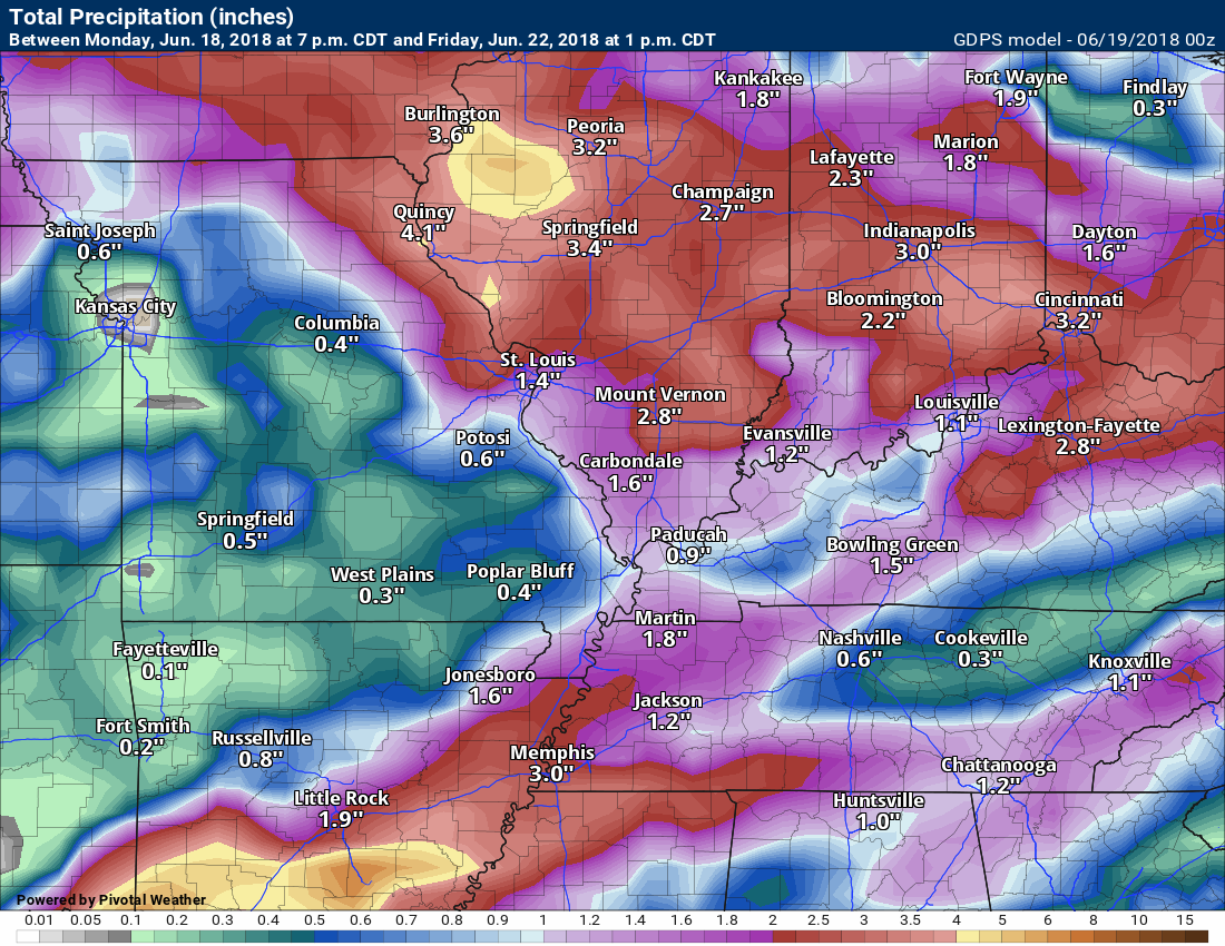
We will have on and off thunderstorm chances this week.
Heavy rain will occur where thunderstorms form. Last week some areas picked up an inch of rain in less than twenty minutes. This week will be no different. Pockets of flash flooding likely.
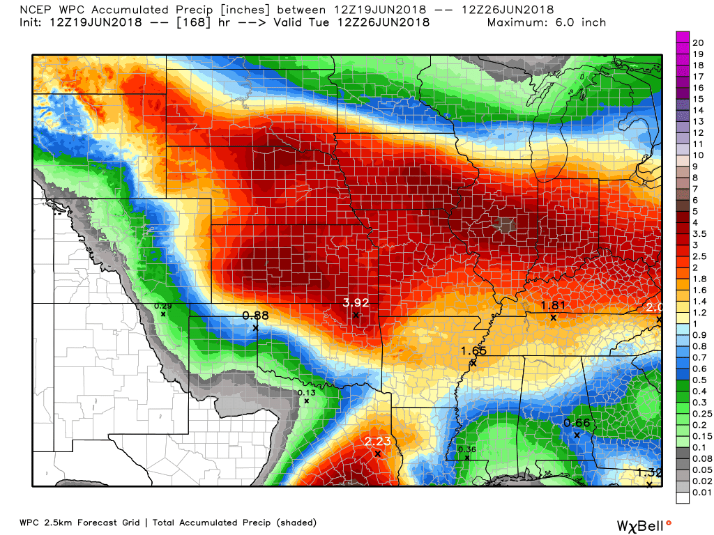
Here is the latest WPC / NOAA
A WIDE range of rainfall totals (even within the same county).
This graphic will not cover those wild swings in rainfall totals that occur from locally heavy thunderstorms.
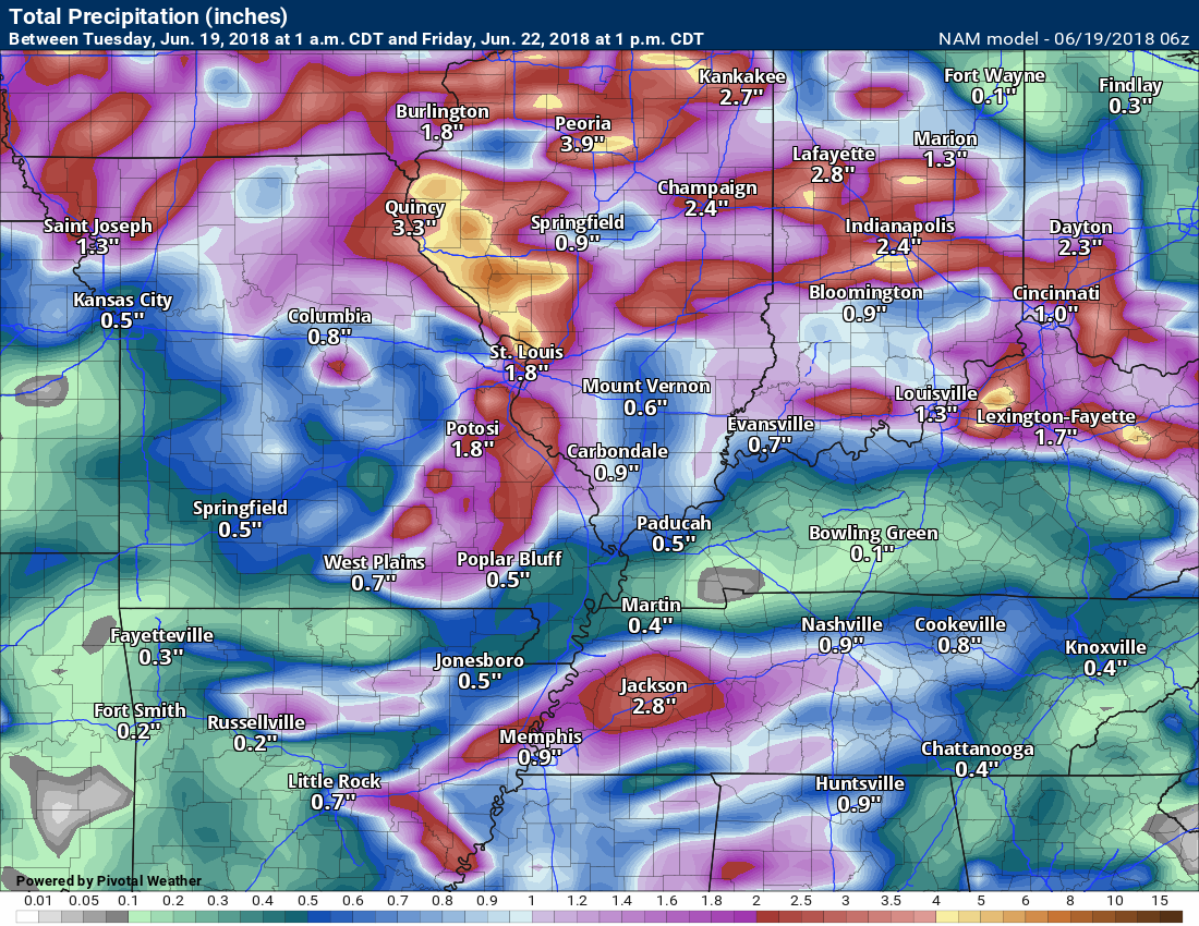
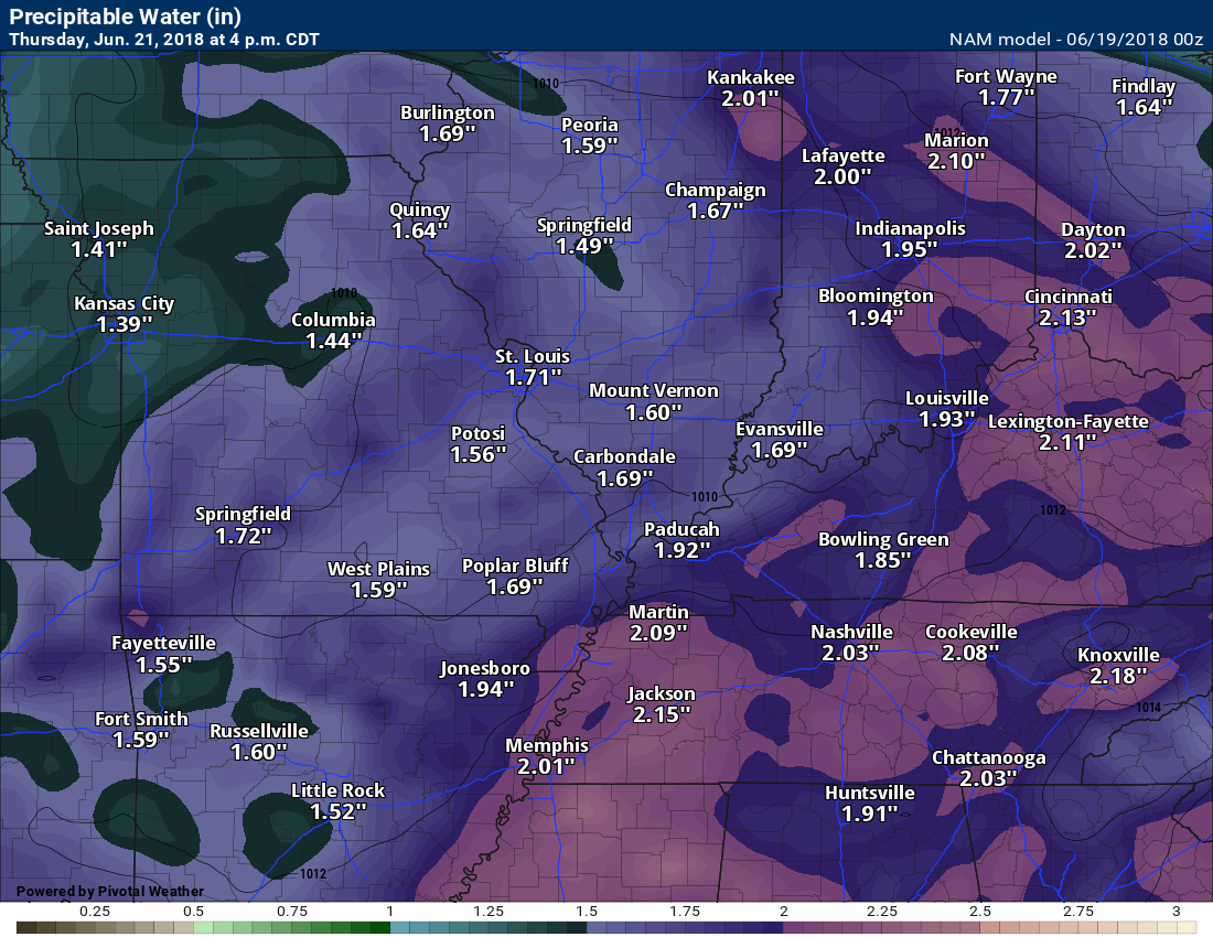
This next graphic is the NAM model guidance rainfall forecast
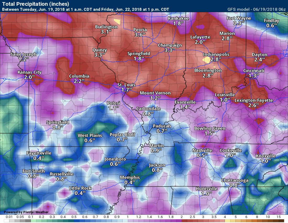
Click images to enlarge
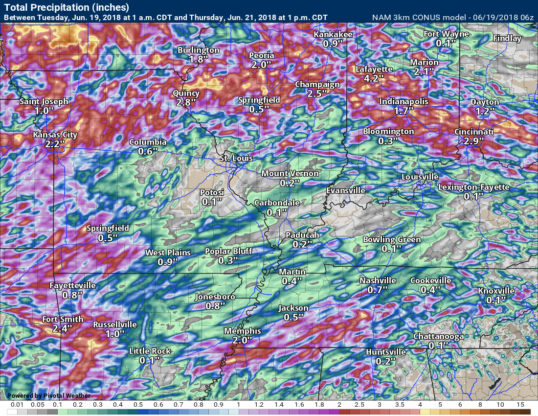
The NAM model
This next graphic is the GFS
This next graphic is the GEM model rainfall
.

We offer interactive local city live radars and regional radars. If a radar does not update then try another one.
If a radar does not appear to be refreshing then hit Ctrl F5 on your keyboard.
You may also try restarting your browser.
The local city view radars also have clickable warnings.
During the winter months, you can track snow and ice by clicking the winterize button on the local city view interactive radars.

Questions? Broken links? Other questions?
You may email me at beaudodson@usawx.com

The National Weather Service defines a severe thunderstorm as one that produces quarter size hail or larger, 58 mph winds or greater, and/or a tornado.
Tuesday through Thursday: We will have thunderstorm chances. Some of the storms will be intense. The greatest coverage should arrive Thursday into Thursday night.
Heavy rain is likely where storms form. There will also be a risk of downburst winds. Downburst winds can exceed 50 mph. Some of the most intense storms could produce hail. Last week one county received ping pong size hail.
Thunderstorms, during the summer months, can produce frequent cloud to ground lightning. Monitor updates. Some storms could become severe.
Friday through Sunday: Additional thunderstorms are possible during this time frame. There is a lot of uncertainty on the coverage.
What are downbursts?

Interactive live weather radar page. Choose the city nearest your location. If one of the cities does not work then try a nearby one. Click here.
National map of weather watches and warnings. Click here.
Storm Prediction Center. Click here.
Weather Prediction Center. Click here.

Live lightning data: Click here.

Interactive GOES R satellite. Track clouds. Click here.

Here are the latest local river stage forecast numbers Click Here.
Here are the latest lake stage forecast numbers for Kentucky Lake and Lake Barkley Click Here.

The spring and preliminary summer outlooks have been posted for subscribers. Scroll down to see the outlook.Not a subscriber? Learn more at this link.

Weather Headlines
- Warm and muggy weather
- Thunderstorm chances
- Peak rain chances should be Thursday into Thursday night
- Tropical moisture feed could mean heavy rain totals (for some)
A great photograph by Jacob Woods. Kentucky Lake.
Our weather pattern is about to turn a bit more active. With that said, there does remain questions on timing and coverage of precipitation.
I feel confident we will have several periods of time where thunderstorm activity will increase.
Temperatures will be a little cooled based on cloud cover and precipitation, especially as we head into Thursday through Sunday. At one time Sunday looked to be even hotter, but latest guidance has trended towards a cooler solution (relatively speaking).
Thunderstorm activity today will be isolated to widely scattered. Same for tonight. Any storms that form could be strong. Thunderstorm chances will range from 10% to 20% through Tuesday night.
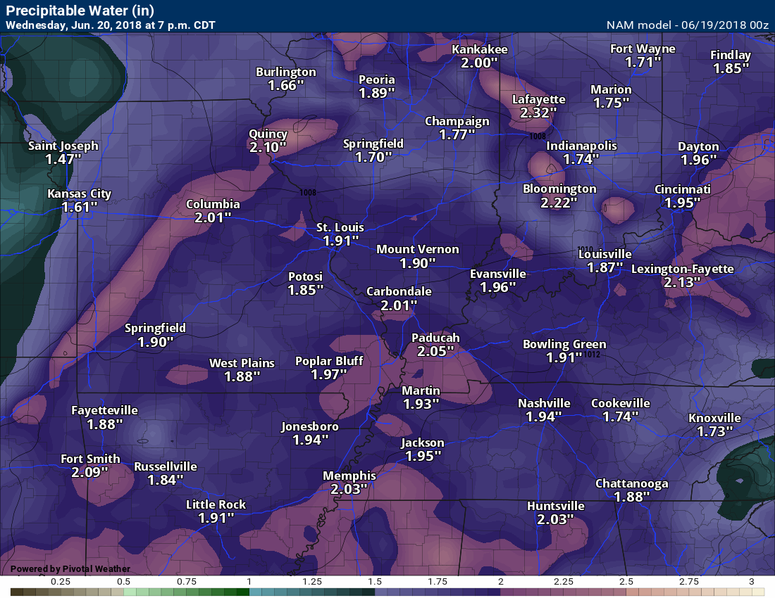
Wednesday into Wednesday night we should see more activity than Tuesday. Any storms that form could be strong. Heavy rain is a concern from slow moving thunderstorms. PWAT values are very high. That equals heavy rain. PWAT is a measure of moisture in the atmosphere.
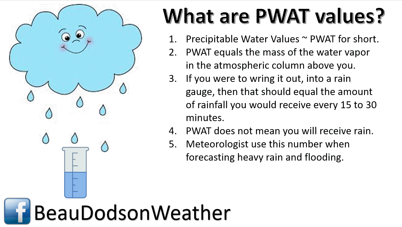
Here are the Wednesday and Thursday PWAT values.
I consider high PWAT values to be 1.7″ or above. Very high numbers would be 2″ and above.
These are large numbers. Thunderstorms that form could be intense and could produce very heavy downpours.
Thursday
Click to enlarge images.
Here is the Wednesday evening forecast weather map. Notice the low pressure center entering southeast Nebraska and a stationary front extending into Indiana.
The red zone is where thunderstorm activity should be focused. Meaning, increase activity. Increased areal coverage.
The green zone is where thunderstorms are possible, but coverage won’t be as great.
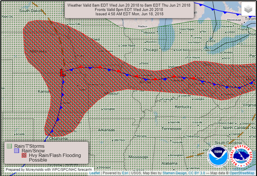
Thursday into Thursday night may be the peak of the thunderstorm chances. Thunderstorms could produce locally heavy rain. We will need to monitor the flash flood threat. If storms train over the same areas then flash flooding would likely occur.
Friday into Sunday will continue to theme of the week. Warm and muggy. Showers and thunderstorms will be possible. I am not as certain about coverage of thunderstorm activity Friday into Sunday. Monitor updated forecast numbers.
With the chance of showers and thunderstorms I have lowered temperatures a few degrees. Expect widespread 85 to 90 degree readings Wednesday into Sunday.
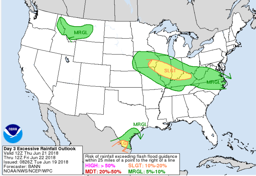
We do have a marginal to slight risk of flash flooding over the coming days. Thursday may be the main concern.
The WPC/NOAA has outlined our region for some flash flooding potential Thursday into Thursday night.
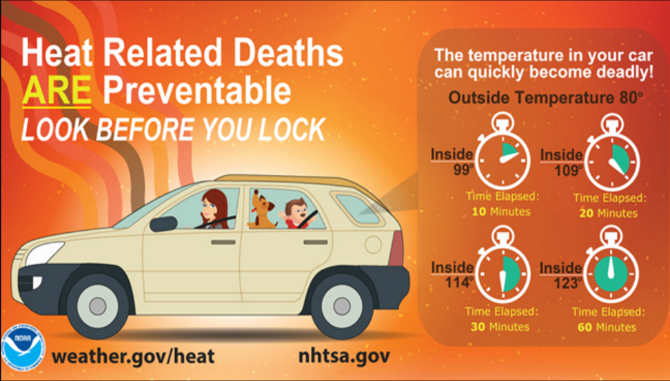
Do you know the symptoms of heat related illness?
Also, don’t forget our outdoor friends.

![]()
![]()

A new weather podcast is now available! Weather Geeks (which you might remember is on The Weather Channel each Sunday)
To learn more visit their website. Click here.
![]()

WeatherBrains Episode 647
WeatherBrains Episode 647 is now online (June 11, 2018).
If you are crazy about weather, this is THE netcast audio program for you!
This week’s Guest WeatherBrain is a Philom. We will find out exactly what that means in a moment. He is the seventh editor of Farmers’ Almanac, which is significant, given that it was founded in 1818. Peter Geiger, welcome to WeatherBrains!
Other discussions in this weekly podcast include topics like:
Sun spot cycles
Tropical disturbance in the Caribbean
Meaning of the word “Philom”
Astronomy Outlook with Tony Rice
and more!
Previous episodes can be viewed by clicking here.
We offer interactive local city live radars and regional radars. If a radar does not update then try another one. If a radar does not appear to be refreshing then hit Ctrl F5. You may also try restarting your browser.
The local city view radars also have clickable warnings.
During the winter months, you can track snow and ice by clicking the winterize button on the local city view interactive radars.
You may email me at beaudodson@usawx.com
Find me on Facebook!

Find me on Twitter!

Did you know that a portion of your monthly subscription helps support local charity projects?
You can learn more about those projects by visiting the Shadow Angel Foundation website and the Beau Dodson News website.

I encourage subscribers to use the app vs regular text messaging. We have found text messaging to be delayed during severe weather. The app typically will receive the messages instantly. I recommend people have three to four methods of receiving their severe weather information.
Remember, my app and text alerts are hand typed and not computer generated. You are being given personal attention during significant weather events.
