Morning update posted a 8 am on June 16, 2017.
Friday, June 16, 2017


Videos can be viewed at this link. Long Range Video Update
If you believe you missed a video then you can also click the LIVE FEED link on the Weather Talk website. That page holds links for several days.
I can text you the videos, as well. Make sure you have text option FOUR turned on. That would be the Weather Extra text option. Sign up for the text messages at www.beaudodsonweather.com
.
 .
..
This forecast update covers southern Illinois, southeast Missouri, western Kentucky. and northwest Tennessee.
June 15, 2017
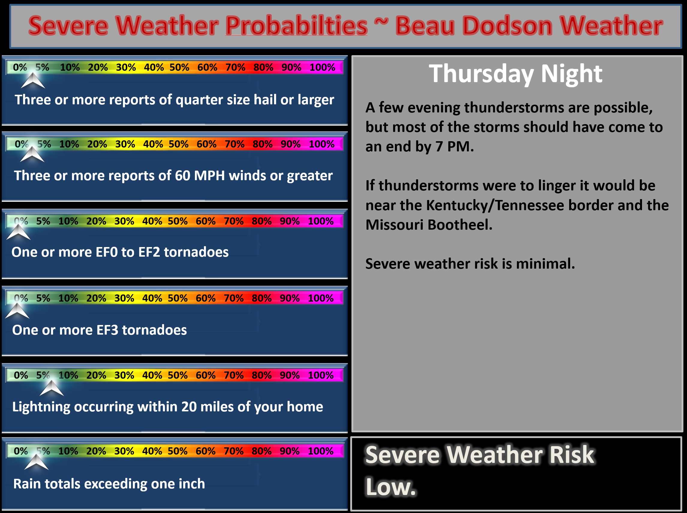
Thursday Night Forecast Details:
Forecast: Partly cloudy. Perhaps an isolated shower or thunderstorm during the evening. Many areas will be dry overnight. Patchy dense fog possible.
Temperatures: MO ~ 70 to 74 IL ~ 70 to 74 KY ~ 70 to 74 TN ~ 70 to 74
Winds: Variable winds before 1 am and then the winds will become more south and southwest at 6 to 12 mph
My confidence in the forecast verifying: Medium. Some adjustments are possible
What impacts are anticipated from the weather? Most areas will have no impact. I can’t rule out a few wet roadways during the evening hours and lightning. Fog could lower visibility.
Is severe weather expected? No
The NWS defines severe weather as 58 mph winds or great, 1″ hail or larger, and/or tornadoes
What is the chance of precipitation? MO ~ 20% IL ~ 20% KY ~ 20% TN ~ 30%
Coverage of precipitation: None to isolated
Should I cancel my outdoor plans? No, but check radars.
.
Live radars ~ click here
Live lightning data ~ click here
.
June 16, 2017
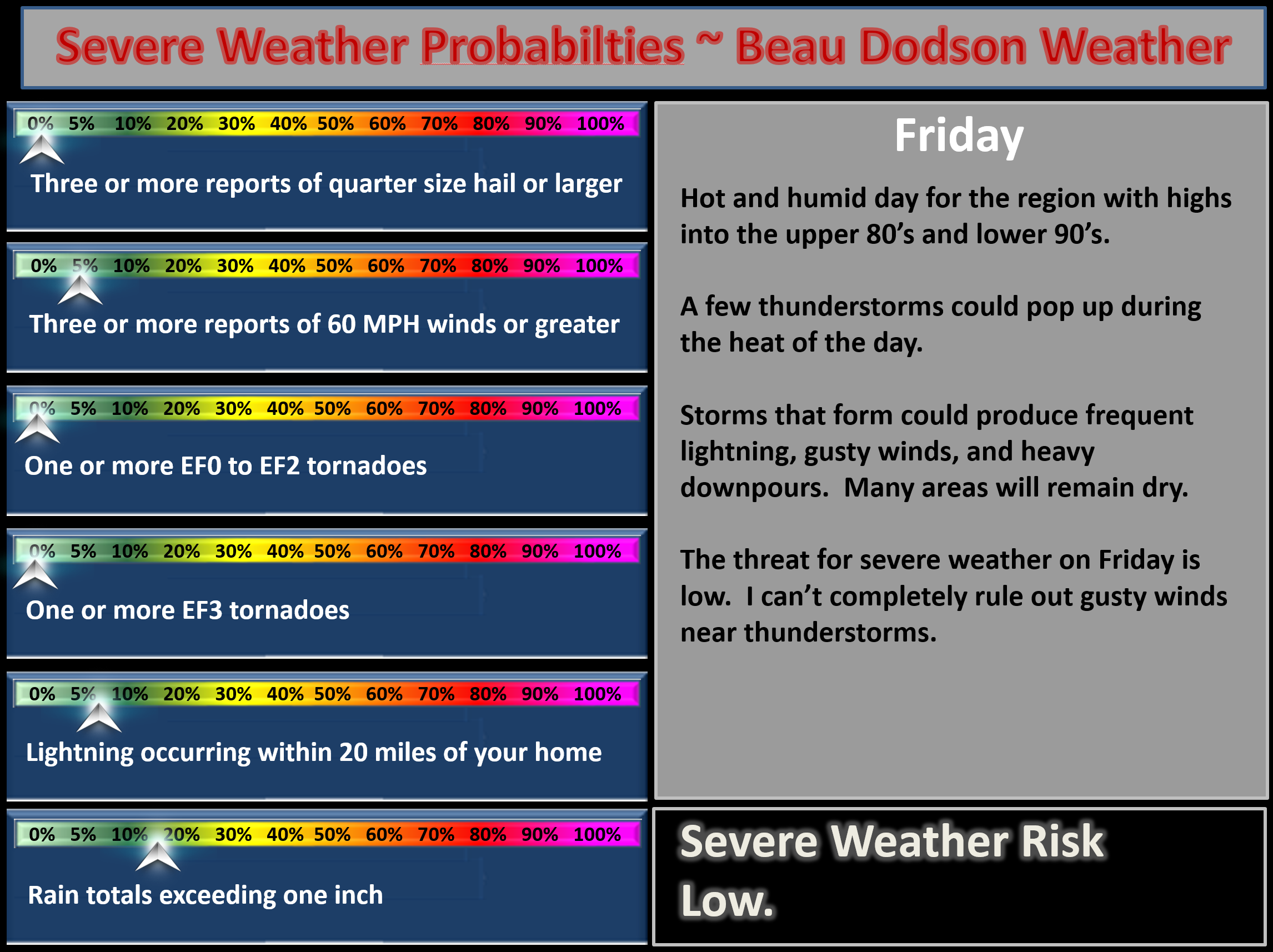
Friday Forecast Details
Forecast: Partly cloudy. Hot and humid. A chance for scattered showers and thunderstorms.
Temperatures: MO ~ 88 to 94 IL 88 to 94 KY 86 to 94 TN 88 to 94
Winds: South and southwest winds at 5 to 10 mph with gusts to 15 mph
What impacts are anticipated from the weather? A few wet roadways and heavy downpours. Lightning.
My confidence in the forecast verifying: Medium. Some adjustments are possible
Is severe weather expected? Small risk for damaging winds with the most intense storms.
The NWS defines severe weather as 58 mph winds or great, 1″ hail or larger, and/or tornadoes
What is the chance of precipitation? MO ~ 40% IL ~ 30% KY ~ 30% TN ~ 30%
Coverage of precipitation: Scattered to perhaps some sort of line of storms for extreme southern Missouri into western Tennessee. Lower confidence north of that line.
Should I cancel my outdoor plans? No, but check radars
.
Friday Night Forecast Details:
Forecast: Partly cloudy. Warm. Humid. A shower or thunderstorm possible.
Temperatures: MO ~ 68 to 72 IL ~ 68 to 72 KY ~ 68 to 74 TN ~ 68 to 74
Winds: South at 5 mph with gusts to 10 mph
My confidence in the forecast verifying: Medium. Some adjustments are possible.
What impacts are anticipated from the weather? A few wet roadways and heavy downpours. Lightning. Pea size hail
Is severe weather expected? Unlikely
The NWS defines severe weather as 58 mph winds or great, 1″ hail or larger, and/or tornadoes
What is the chance of precipitation: MO ~ 30% IL ~ 30% KY ~ 20% TN ~ 20%
Coverage of precipitation: Isolated to perhaps scattered.
Should I cancel my outdoor plans? No, but monitor updates
.
June 17, 2017
Saturday Forecast Details
Forecast: Partly sunny. A shower or thunderstorm possible. Hot and humid.
Temperatures: MO ~ 88 to 94 IL 88 to 94 KY 88 to 94 TN 88 to 94
Winds: South winds 5 to 10 mph with gusts to 15 mph
What impacts are anticipated from the weather? A few wet roadways and heavy downpours. Lightning.
My confidence in the forecast verifying: Medium. Some adjustments are possible.
Is severe weather expected? Small risk that a storm could produce high winds.
The NWS defines severe weather as 58 mph winds or great, 1″ hail or larger, and/or tornadoes
What is the chance of precipitation? MO ~ 30% IL ~ 30% KY ~ 30% TN ~ 30%
Coverage of precipitation: Widely scattered
Should I cancel my outdoor plans? No, but monitor updates and radars. Have a backup plan in mind in case thunderstorm coverage is greater.
.
Saturday Night Forecast Details:
Forecast: Partly cloudy. A thunderstorm possible. Perhaps the best chance will be over the northern parts of southeast Missouri and the northern parts of southern Illinois.
Temperatures: MO ~ 70 to 74 IL ~ 70 to 74 KY ~ 70 to 74 TN ~ 70 to 74
Winds: South at 5 to 10 mph with gusts to 15 mph
My confidence in the forecast verifying: Medium. Some adjustments are possible.
What impacts are anticipated from the weather? A few wet roadways and heavy downpours. Lightning. Pea size hail
Is severe weather expected? Small risk for damaging winds.
The NWS defines severe weather as 58 mph winds or great, 1″ hail or larger, and/or tornadoes
What is the chance of precipitation: MO ~ 30% IL ~ 30% KY ~ 30% TN ~ 30%
Coverage of precipitation: Isolated to scattered.
Should I cancel my outdoor plans? No, but monitor radars and updates. Have a plan B in mind
.
June 18, 2017
Sunday Forecast Details
Forecast: Partly sunny. Warm and humid. A good chance for showers and thunderstorms along an incoming cold front. Some storms could be strong.
Temperatures: MO ~ 86 to 92 IL 86 to 92 KY 86 to 92 TN 86 to 92
Winds: South at 5 to 10 mph with gusts to 15 mph. Stronger winds near thunderstorms.
What impacts are anticipated from the weather? Wet roadways and lightning. Heavy downpours where storms do occur. High winds possible with some storms. Hail possible with a few storms.
My confidence in the forecast verifying: Medium. Some adjustments are possible.
Is severe weather expected? A marginal risk for damaging winds and hail.
The NWS defines severe weather as 58 mph winds or great, 1″ hail or larger, and/or tornadoes
What is the chance of precipitation? MO ~ 60% IL ~ 60% KY ~ 60% TN ~ 60%
Coverage of precipitation: Becoming numerous.
Should I cancel my outdoor plans? No, but monitor radars and updates. Have a plan B in mind.
.
Sunday Night Forecast Details:
Forecast: Partly cloudy. A chance for evening storms.
Temperatures: MO ~ 64 to 68 IL ~ 64 to 68 KY ~ 64 to 68 TN ~ 64 to 68
Winds: Winds becoming west and northwest at 6 to 12 mph
My confidence in the forecast verifying: Medium. Some adjustments are possible.
What impacts are anticipated from the weather? Wet roadways and lightning. Heavy downpours where storms do occur
Is severe weather expected? A marginal risk for damaging winds.
The NWS defines severe weather as 58 mph winds or great, 1″ hail or larger, and/or tornadoes
What is the chance of precipitation: MO ~ 40% IL ~ 40% KY ~ 50% TN ~ 50%
Coverage of precipitation: Coverage diminishing overnight.
Should I cancel my outdoor plans? No, but monitor radars and updates. Have a plan B in mind.
.
June 19, 2017
Monday Forecast Details
Forecast: Partly to mostly sunny. Perhaps a little cooler and less humid. Small chance for isolated storms.
Temperatures: MO ~ 82 to 86 IL 82 to 86 KY 82 to 86 TN 82 to 86
Winds: Northwest at 5 to 10 mph
What impacts are anticipated from the weather? Most likely none. A small chance for isolated thunderstorms.
My confidence in the forecast verifying: Medium. Some adjustments are possible.
Is severe weather expected? No
The NWS defines severe weather as 58 mph winds or great, 1″ hail or larger, and/or tornadoes
What is the chance of precipitation? MO ~ 20% IL ~ 20% KY ~ 20% TN ~ 20%
Coverage of precipitation: Isolated
Should I cancel my outdoor plans? No
.
Monday Night Forecast Details:
Forecast: Partly cloudy. Perhaps a little cooler and less humid.
Temperatures: MO ~ 64 to 68 IL ~ 60 to 66 KY ~ 64 to 68 TN ~ 64 to 68
Winds: Northwest at 5 mph
My confidence in the forecast verifying: Medium. Some adjustments are possible.
What impacts are anticipated from the weather? None
Is severe weather expected? No
The NWS defines severe weather as 58 mph winds or great, 1″ hail or larger, and/or tornadoes
What is the chance of precipitation: MO ~ 0% IL ~ 0% KY ~ 0% TN ~ 0%
Coverage of precipitation: None
Should I cancel my outdoor plans? No
.
June 20, 2017
Tuesday Forecast Details
Forecast: Partly sunny. Warm.
Temperatures: MO ~ 84 to 88 IL 84 to 88 KY 84 to 88 TN 84 to 88
Winds: North and northwest at 6 to 12 mph
What impacts are anticipated from the weather? None
My confidence in the forecast verifying: Medium. Some adjustments are possible.
Is severe weather expected? No
The NWS defines severe weather as 58 mph winds or great, 1″ hail or larger, and/or tornadoes
What is the chance of precipitation? MO ~ 0% IL ~ 0% KY ~ 0% TN ~ 0%
Coverage of precipitation: None
Should I cancel my outdoor plans? No
.
Tuesday Night Forecast Details:
Forecast: Partly cloudy. Perhaps a little cooler and less humid.
Temperatures: MO ~ 62 to 66 IL ~ 62 to 66 KY ~ 62 to 66 TN ~ 62 to 66
Winds: Variable at 5 mph.
My confidence in the forecast verifying: Medium. Some adjustments are possible.
What impacts are anticipated from the weather? None
Is severe weather expected? No
The NWS defines severe weather as 58 mph winds or great, 1″ hail or larger, and/or tornadoes
What is the chance of precipitation: MO ~ 0% IL ~ 0% KY ~ 0% TN ~ 0%
Coverage of precipitation: None
Should I cancel my outdoor plans? No
.
June 21, 2017
Wednesday Forecast Details
Forecast: Partly sunny. Quite warm.
Temperatures: MO ~ 86 to 92 IL 86 to 92 KY 86 to 92 TN 86 to 92
Winds: Variable at 5 to 10 mph
What impacts are anticipated from the weather?
My confidence in the forecast verifying: Low. Significant adjustments possible.
Is severe weather expected? No
The NWS defines severe weather as 58 mph winds or great, 1″ hail or larger, and/or tornadoes
What is the chance of precipitation? MO ~ 20% IL ~ 20% KY ~ 20% TN ~ 20%
Coverage of precipitation:
Should I cancel my outdoor plans? No
.
Wednesday Night Forecast Details:
Forecast: Partly cloudy.
Temperatures: MO ~ 65 to 70 IL ~ 65 to 70 KY ~ 65 to 70 TN ~ 65 to 70
Winds:
My confidence in the forecast verifying: Low. Significant adjustments possible.
What impacts are anticipated from the weather?
Is severe weather expected? No
The NWS defines severe weather as 58 mph winds or great, 1″ hail or larger, and/or tornadoes
What is the chance of precipitation: MO ~ 20% IL ~ 20% KY ~ 20% TN ~ 20%
Coverage of precipitation:
Should I cancel my outdoor plans? No
.
June 22, 2017
Thursday Forecast Details
Forecast: Partly sunny. Quite warm.
Temperatures: MO ~ 86 to 92 IL 86 to 92 KY 86 to 92 TN 86 to 92
Winds:
What impacts are anticipated from the weather?
My confidence in the forecast verifying: Low. Significant adjustments possible.
Is severe weather expected? No
The NWS defines severe weather as 58 mph winds or great, 1″ hail or larger, and/or tornadoes
What is the chance of precipitation? MO ~ 20% IL ~ 20% KY ~ 20% TN ~ 20%
Coverage of precipitation:
Should I cancel my outdoor plans? No
.
Thursday Night Forecast Details:
Forecast: Partly cloudy. Mild.
Temperatures: MO ~ 65 to 70 IL ~ 65 to 70 KY ~ 65 to 70 TN ~ 65 to 70
Winds:
My confidence in the forecast verifying: Low. Significant adjustments possible.
What impacts are anticipated from the weather?
Is severe weather expected? No
The NWS defines severe weather as 58 mph winds or great, 1″ hail or larger, and/or tornadoes
What is the chance of precipitation: MO ~ 20% IL ~ 20% KY ~ 20% TN ~ 20%
Coverage of precipitation:
Should I cancel my outdoor plans? No
.
June 23, 2017
Friday Forecast Details
Forecast: Partly sunny. Quite warm.
Temperatures: MO ~ 86 to 92 IL 86 to 92 KY 86 to 92 TN 86 to 92
Winds:
What impacts are anticipated from the weather?
My confidence in the forecast verifying: Low. Significant adjustments possible.
Is severe weather expected? No
The NWS defines severe weather as 58 mph winds or great, 1″ hail or larger, and/or tornadoes
What is the chance of precipitation? MO ~ 20% IL ~ 20% KY ~ 20% TN ~ 20%
Coverage of precipitation:
Should I cancel my outdoor plans? No
.
Friday Night Forecast Details:
Forecast: Partly cloudy. Mild.
Temperatures: MO ~ 65 to 70 IL ~ 65 to 70 KY ~ 65 to 70 TN ~ 65 to 70
Winds:
My confidence in the forecast verifying: Low. Significant adjustments possible.
What impacts are anticipated from the weather?
Is severe weather expected? No
The NWS defines severe weather as 58 mph winds or great, 1″ hail or larger, and/or tornadoes
What is the chance of precipitation: MO ~ 20% IL ~ 20% KY ~ 20% TN ~ 20%
Coverage of precipitation:
Should I cancel my outdoor plans? No
.
.
Don’t forget to check out the Southern Illinois Weather Observatory web-site for weather maps, tower cams, scanner feeds, radars, and much more! Click here
.

A severe thunderstorm is defined as a storm that produces quarter size hail or larger, 58 mph winds or greater, and/or a tornado. That is the official National Weather Service definition of a severe thunderstorm.
Thursday night through Sunday night: Thunderstorms will remain in the forecast through Sunday evening. A few strong storms are possible through Saturday night.
A few storms could become severe on Sunday with damaging winds and hail. The overall severe weather risk is small, but not zero. Monitor the day to day forecast details at the top of the blog.
Any of the storms that form could produce heavy downpours, gusty winds, and cloud to ground lightning. The more intense storms could also produce small hail.
Monday through Friday of next week: Severe weather is not anticipated. Uncertainties surround thunderstorm chances beyond Wednesday. Monitor updates.
Severe Weather Probabilities for tonight and Thursday
Click to enlarge images

Weather Analysis for the coming week:
Interactive Weather Radar Page. Choose the city nearest your location: Click this link
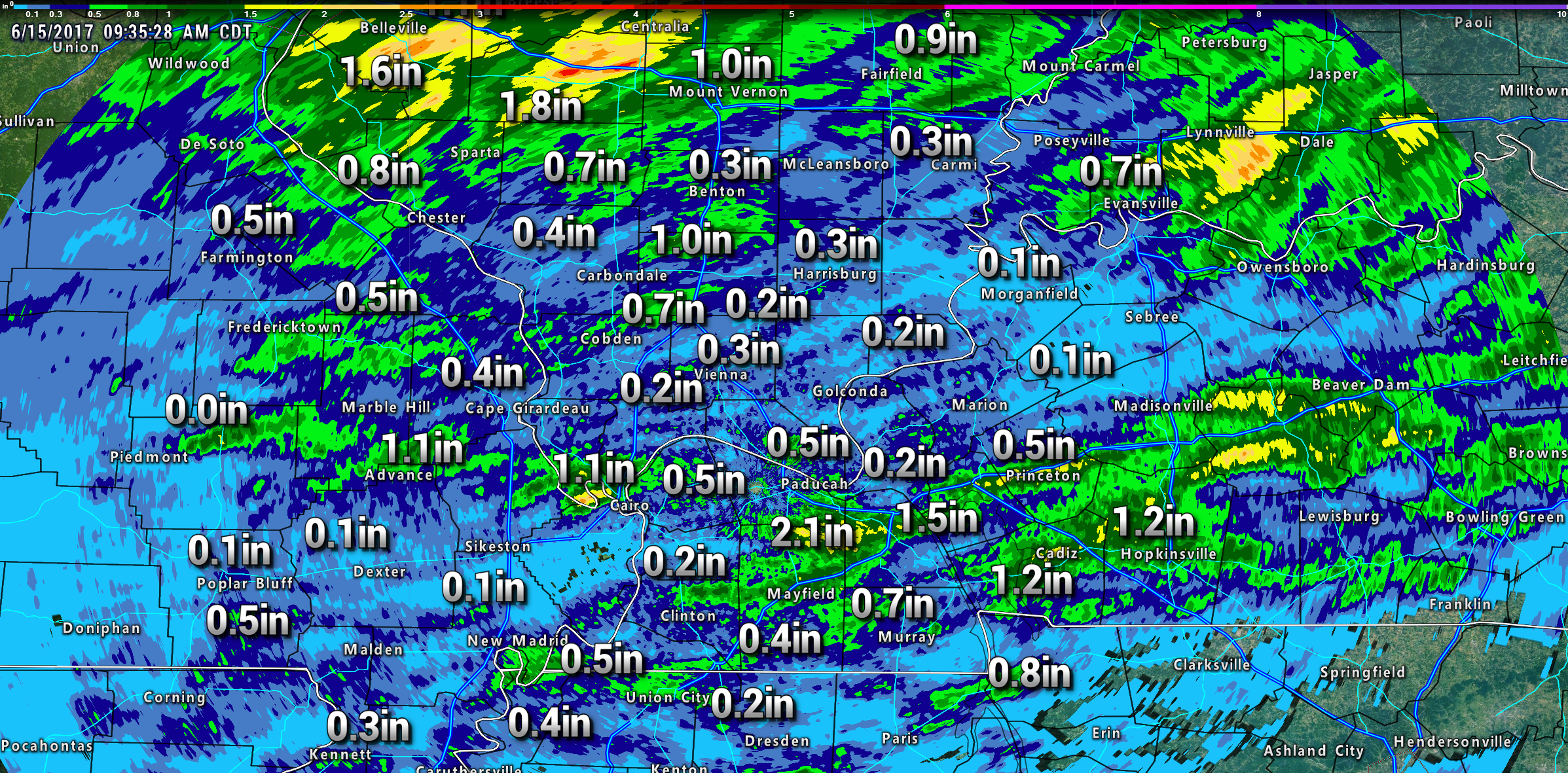
Showers and thunderstorms swept through the region late Wednesday night into Thursday morning. Rainfall totals ranged from 0.00″ to nearly two inches.
Quite a few of you woke up to lightning and thunder. I did see a few shelf cloud photographs. They are always photogenic.
That band of showers and storms moved off to our south and east by the late morning hours and that left us with a mix of sun and clouds. Warm and humid air, as well.
Radar estimated rainfall totals. Click image to enlarge.
Rainfall totals varied greatly from county to county. Typical for summer.
Friday into Saturday night:
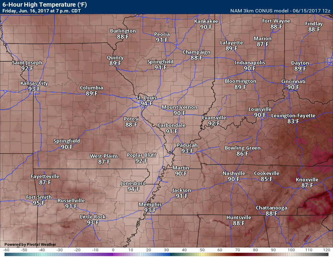
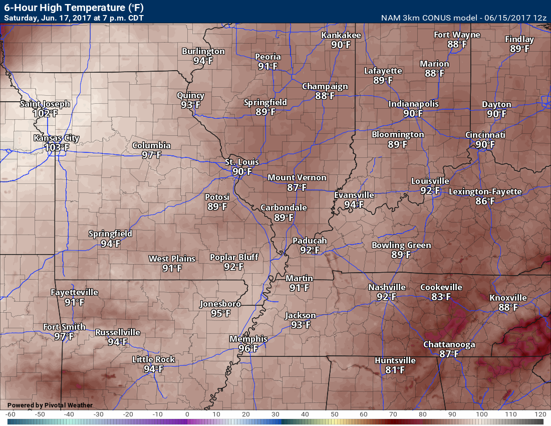
How and muggy conditions will be with us into the weekend. Both Friday and Saturday will deliver temperatures into the 90’s. Heat index values of 95 to 102 degrees. Uncomfortable for many. Peak hours for the heat index will be between 1 pm and 7 pm.
Winds will remain mostly out of the south and southwest at 6 to 12 mph with a few higher gusts.
There will be a 30% for storms on Friday, Friday night, Saturday, and Saturday night. There is a small chance of an MCS impacting the region during that time frame, but I think the greatest precipitation coverage remains out of our local area. If an MCS or decaying MCS were to move into our region then I would need to raise rain probabilities. For now, I will leave the forecast as is.
Friday high temperature forecast
Saturday high temperature forecast
Sunday and Sunday night:
A cold front will move through the region on Sunday and Sunday night. This will bring a temporary end to the hot and muggy conditions. Collective cheer? I hear some of you, but not all!
I know some of you like the hot weather. I don’t mind hot weather, but I am not a fan of the high dew points/humidity.
You can see the cold front on this surface map for Sunday morning.
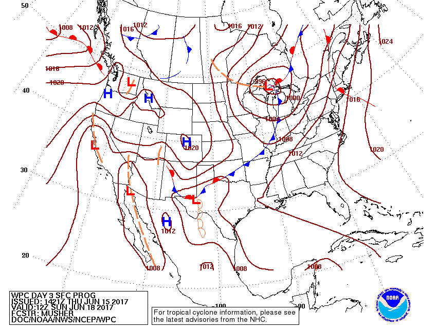
The front will bump into the warm and humid air-mass. This will spark showers and thunderstorms.
I am expecting a band of showers and thunderstorms to be moving in the region from the north and west on Sunday morning into the afternoon hours. How early in the day the cloud cover moves in will be important. If the atmosphere has time to become unstable then a few severe thunderstorms will be possible. This will need to be monitored. Confidence in the severe weather risk on Sunday is low. Monitor updates.
If the front arrives early in the day, and we have plenty of cloud cover and precipitation, then the severe weather threat will not be all that great.
Let’s keep an eye on Sunday’s weather.
The main concern would be damaging winds and frequent cloud to ground lightning. Torrential downpours, as well.
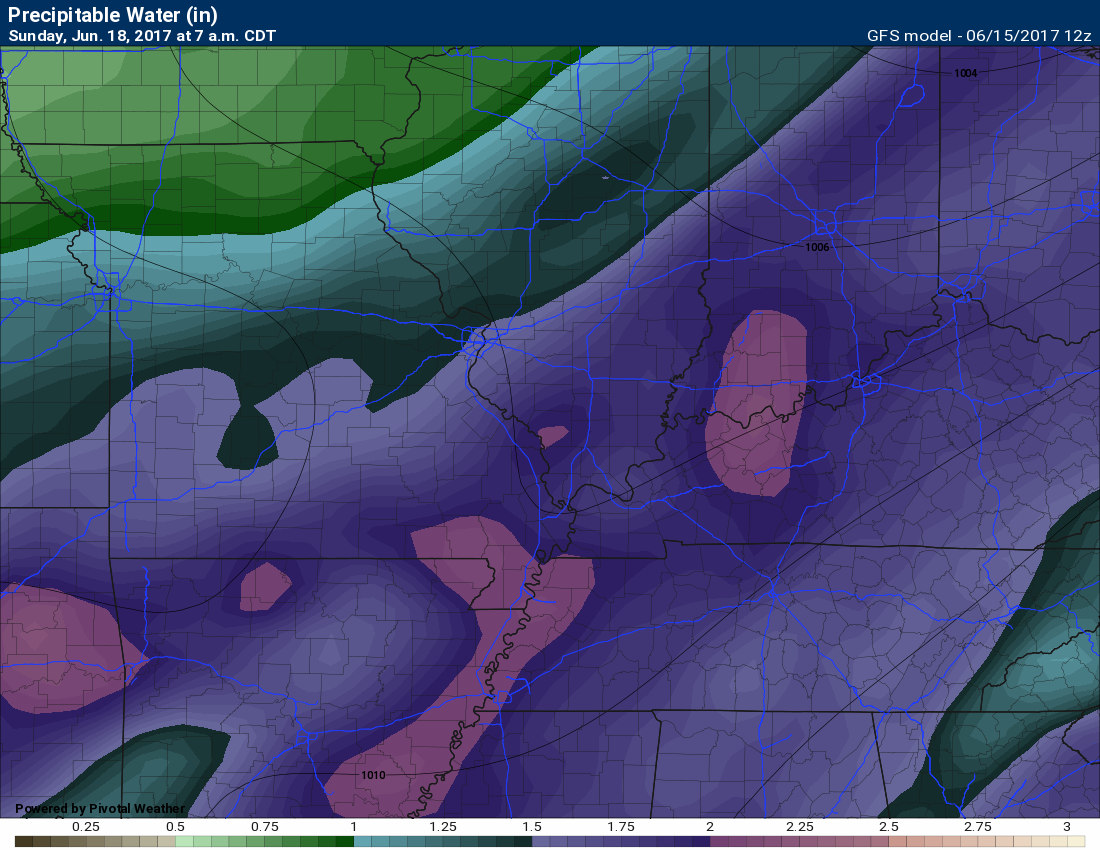
PWAT values will be high. PWAT is a measure of moisture in the entire atmosphere. The higher the number the greater the rainfall rate. PWAT values of 1.7 to 2.o+ are considered high to extreme.
Here is the PWAT values map for Sunday. Very high PWAT values. That could mean heavy rain. Again, some of this will depend on the timing of the frontal passage.
Scale is at the bottom of the graphic.
Future-cast radar images, from different models, show rain chances at any given point in the day.
I am hoping to fine tune the Sunday forecast over the next day or two. Just not sure on timing and coverage. Either way, plan on some Sunday thunderstorms. Locally heavy rain possible.
Monday through Friday of next week:
The cold front will be to our east by Monday. That will mean lower temperatures and lower dew points. Lower dew points will mean a nicer air mass.
Here is the Monday and Tuesday afternoon dew point map
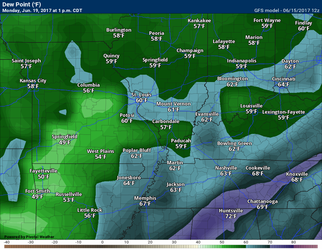
and Tuesday
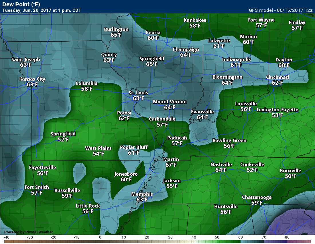
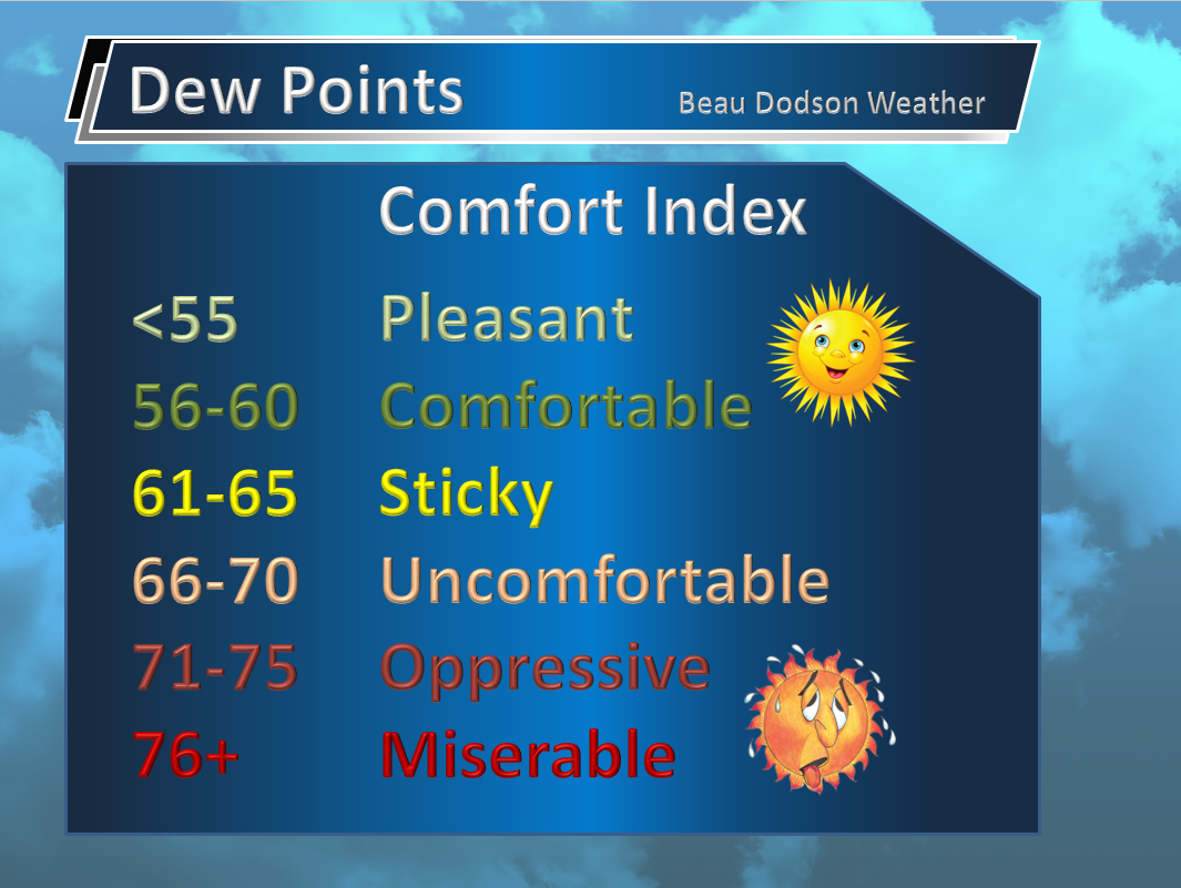
Dew points? This graphic will help you.
Dry weather is anticipated for both Monday and Tuesday. Most likely dry on Wednesday, as well. Models are a bit muddled on rain chances beyond Wednesday. For now, I kept the rain probabilities at 0% to less than 20% during the Monday through Friday time frame of next week. Adjustments possible.
Summer rain probabilities. What you should know
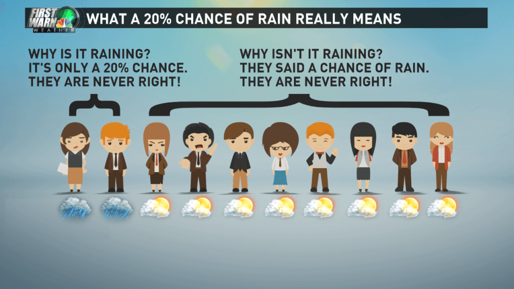
We are entering a summer pattern. Air-mass thunderstorms are common in our region during the months of June through August. Thunderstorm probabilities are often 20% to 30%. What does that mean? It normally means a 100% that someone in the area will receive a thunderstorm. Most areas, however, will remain dry.
Weather forecasting, during the summer months, can be difficult to predict county by county. Mainly because of the random nature of air-mass thunderstorms.
They tend to dot radar, especially during the afternoon and early evening hours. This is because the sun heats the ground and that causes air to rise. Cumulus clouds will form if you have sufficient rising motion. Those Cumulus clouds turn into Cumulonimbus clouds. Cumulonimbus clouds are thunderstorms.
These storms can drop an inch of rain in less than fifteen minutes. I call them gully washers. Meanwhile, your neighbor barely receives a sprinkle.
If you have lived in our region, any amount of time, then you are familiar with these types of thunderstorms. Some meteorologists call them air-mass thunderstorms. Others call them popcorn thunderstorms (because they dot radar).
Occasionally these thunderstorms will produce pockets of wind damage. Downburst winds can exceed 60 mph over small areas. They also produce frequent cloud to ground lightning. If they are slow moving then isolated flash flooding will result.
So the next time you plan an outdoor event and there is a 20% chance for thunderstorms, remember what that 20% actually means.
.
If you have not signed up for the texts messages, then please do. Link www.beaudodsonweather.com
I encourage you to use the app. That app receives the information faster than Verizon or ATT.
Apple app link
https://itunes.apple.com/us/app/id1190136514
Android app link
Remember, the app is for www.weathertalk.com subscribers. The app allows your to receive the text messages faster than ATT and Verizon. If you are not a subscriber then the app won’t work.
Here is the download link for the Android version Click Here
Your support helps with the following:

and


Find me on Twitter
.

We have regional radars and local city radars – if a radar does not update then try another one. Occasional browsers need their cache cleared. You may also try restarting your browser. That usually fixes the problem. Occasionally we do have a radar go down. That is why I have duplicates. Thus, if one fails then try another one.
During the winter you can track snow and ice by clicking the winterize button on the local city view interactive radars.
If you have any problems then please send me an email beaudodson@usawx.com
Interactive Weather Radar Page. Choose the city nearest your location: Click this link—
National interactive radar: Click this link.
Local interactive city radars include St Louis, Mt Vernon, Evansville, Poplar Bluff, Cape Girardeau, Marion, Paducah, Hopkinsville, Memphis, Nashville, Dyersburg, and all of eastern Kentucky. These are interactive radars. Local city radars – click here
.

The official 6-10 day and 8-14 day temperature and precipitation outlook. Check the date stamp at the top of each image (so you understand the time frame).
.
The forecast maps below are issued by the Weather Prediction Center (NOAA)
.

.

.
The latest 8-14 day temperature and precipitation outlook. Note the dates are at the top of the image. These maps DO NOT tell you how high or low temperatures or precipitation will be. They simply give you the probability as to whether temperatures or precipitation will be above or below normal.
.


.
The Beau Dodson Weather APP is ready for Apple and Android users. The purpose of this app is for me to deliver your text messages instantly. ATT and Verizon have not always been reliable when it comes to speed. The app allows instant delivery.
Some of you have asked if you can keep receiving the texts on your phone and the app. The answer to that is, yes. The Android app will automatically allow that to happen. On the Apple app, however, you will need to go into your app and click settings. Make sure the green tab is OFF. Off means you will still receive the texts to your phone and the app. If you have any questions, then email me at beaudodson@usawx.com
The app is for text subscribers.
The direct download, for the Apple app, can be viewed here
https://itunes.apple.com/us/app/id1190136514
If you have not signed up for the texting service then you may do so at www.beaudodsonweather.com

The Android app is also ready.
Remember, the app’s are for www.weathertalk.com subscribers. The app allows your to receive the text messages faster than ATT and Verizon.
Here is the download link for the Android version Click Here

——————————————————–
If you have not signed up for the texts messages, then please do. Link www.beaudodsonweather.com
Your support helps with the following:
and

Who do you trust for your weather information and who holds them accountable?
I have studied weather in our region since the late 1970’s. I have 39 years of experience in observing our regions weather patterns. My degree is in Broadcast Meteorology and a Bachelor’s of Science.
My resume includes:
Member of the American Meteorological Society.
NOAA Weather-Ready Nation Ambassador.
Meteorologist for McCracken County Emergency Management. I served from 2005 through 2015.
Meteorologist for McCracken County Rescue. 2015 through current
I own and operate the Southern Illinois Weather Observatory.
I am the chief meteorologist for Weather Talk LLC. I am the owner of Weather Talk LLC.
I am also a business owner in western Kentucky.
Recipient of the Mark Trail Award, WPSD Six Who Make A Difference Award, Kentucky Colonel, and the Caesar J. Fiamma” Award from the American Red Cross.
In 2005 I helped open the largest American Cross shelter in U.S. history in Houston, Texas. I was deployed to help after Hurricane Katrina and Hurricane Rita. I was a shelter manager of one of the Houston, Texas shelter divisions.
In 2009 I was presented with the Kentucky Office of Highway Safety Award.
Recognized by the Kentucky House of Representatives for my service to the State of Kentucky leading up to several winter storms and severe weather outbreaks.
If you click on the image below you can read the Kentucky House of Representatives Resolution.

I am also President of the Shadow Angel Foundation which serves portions of western Kentucky and southern Illinois.
There is a lot of noise on the internet. A lot of weather maps are posted without explanation. Over time you should learn who to trust for your weather information.
My forecast philosophy is simple and straight forward.
- Communicate in simple terms
- To be as accurate as possible within a reasonable time frame before an event
- Interact with you on Twitter, Facebook, email, texts, and this blog
- Minimize the “hype” that you might see on some television stations or through other weather sources
- Push you towards utilizing wall-to-wall LOCAL TV coverage during severe weather events
Many of the graphics on this page are from www.weatherbell.com
WeatherBell is a great resource for weather model guidance.


You can sign up for my AWARE email by clicking here I typically send out AWARE emails before severe weather, winter storms, or other active weather situations. I do not email watches or warnings. The emails are a basic “heads up” concerning incoming weather conditions