For $5 a month you can receive the following. You may choose to receive these via your WeatherTalk app or regular text messaging.
- Severe weather app/text alerts from my keyboard to your app/cell phone. These are hand typed by Beau. During tornado outbreaks, you will receive numerous app/text messages telling you exactly where the tornado is located.
- Daily forecast app/texts from my computer to your app/cell phone.
- Social media links sent directly to your app/cell phone. When I update the blog, videos, or Facebook you will receive the link.
- AWARE emails. These emails keep you well ahead of the storm. They give you several days of lead time before significant weather events.
- Direct access to Beau via text and email. Your very own personal meteorologist. I work for you!
- Missouri and Ohio Valley centered video updates
- Long-range weather videos
- Week one, two, three and four temperature and precipitation outlooks.
- Monthly outlooks.
- Your subscription also will help support several local charities.
Haven’t you subscribed? Subscribe at www.beaudodsonweather.com

Your subscription also helps support these local charities and projects.

I encourage subscribers to use the app vs regular text messaging. We have found text messaging to be delayed during severe weather. The app typically will receive the messages instantly. I recommend people have three to four methods of receiving their severe weather information.
Remember, my app and text alerts are hand typed and not computer generated. You are being given personal attention during significant weather events.

WWW.WEATHERTALK.COM subscribers, here is my day to day schedule for your weather products.


Interactive live weather radar page. Choose the city nearest your location. If one of the city radars won’t load then try a nearby one. Click here.
June 01, 2018
Friday Forecast Details
Forecast: A mix of sun and clouds. Morning rain should come to an end. Early AM storms in the Missouri Bootheel and NW Tennessee. Becoming hot and muggy. Isolated to widely scattered showers and thunderstorms. We may have a CAP today that could prevent storms from forming. I keft a slight chance in the forecast.
Temperatures: MO ~ 88 to 94 IL ~ 88 to 94 KY ~ 88 to 94 TN ~ 88 to 94
What is the chance of precipitation? MO ~ 30% IL ~ 20% KY ~ 40% TN ~ 40%
Coverage of precipitation: Isolated to widely scattered. A bit more widespread early this morning along the KY/TN border. Bootheel, as well. Northwest Tennessee, as well.
Winds: West and southwest at 5 to 10 mph
What impacts are anticipated from the weather? Wet roads and lightning. Heavy rain possible.
My confidence in the forecast verifying: Medium
Is severe weather expected? Storms could produce a few reports of hail and strong winds.
The NWS defines severe weather as 58 mph wind or great, 1″ hail or larger, and/or tornadoes
Should I cancel my outdoor plans? No, but check radars
UV Index: 10 High
Sunrise: 5:36 AM
Friday Night Forecast Details:
Forecast: Mostly clear. Patchy fog. A few evening clouds. Some increase in clouds overnight across southeast Missouri and southwest Illinois. Warm and humid. A chance of an evening thunderstorm. A chance of late night storms mainly over southeast Missouri. I will be monitoring an incoming line of thunderstorms from Missouri. It is forecast to weaken as it moves into our area.
Temperatures: MO ~ 66 to 74 IL ~ 68 to 72 KY ~ 68 to 70 TN ~ 68 to 72
What is the chance of precipitation? MO ~ 30% IL ~ 20% KY ~ 20% TN ~ 20%
Coverage of precipitation: Isolated to scattered.
Winds: Variable at 4 to 8 mph
What impacts are anticipated from the weather? Wet roadways. Lightning. Locally heavy rain.
My confidence in the forecast verifying: Medium
Is severe weather expected? Unlikely, but monitor updates
The NWS defines severe weather as 58 mph wind or great, 1″ hail or larger, and/or tornadoes
Should I cancel my outdoor plans? No, but check radars
Sunset: 8:09 PM
Moonrise: 10:43 PM Waning Gibbous
Moonset: 8:06 AM
June 02, 2018
Saturday Forecast Details
Forecast: Partly sunny. Hot and muggy. Scattered showers and locally heavy thunderstorms. The best chance will be during the afternoon and evening hours. There are questions about whether or not our atmosphere will be unstable enough for severe weather. This is highly dependent on what happens to our northwest Friday night and Saturday morning. Monitor updates.
Temperatures: MO ~ 86 to 90 IL ~ 86 to 90 KY ~ 86 to 90 TN ~ 86 to 90
What is the chance of precipitation? MO ~ 50% IL ~ 40% KY ~ 40% TN ~ 40%
Coverage of precipitation: Scattered to perhaps numerous late in the day. Greatest coverage may be over southeast Missouri.
Winds: South and southeast at 5 to 10 mph with gusts to 14
What impacts are anticipated from the weather? Scattered wet roads and lightning. Heavy rain possible where storms occur. Monitor the severe weather risk.
My confidence in the forecast verifying: Medium
Is severe weather expected? Some storms could be severe. Monitor updates.
The NWS defines severe weather as 58 mph wind or great, 1″ hail or larger, and/or tornadoes
Should I cancel my outdoor plans? No, but check radars
UV Index: 10 High
Sunrise: 5:35 AM
Saturday Night Forecast Details:
Forecast: Partly cloudy. Warm and humid. Scattered thunderstorms possible. Some of the storms could be severe. Greatest coverage could be over southeast Missouri, but confidence is low. Monitor updates concerning Saturday night’s weather.
Temperatures: MO ~ 65 to 70 IL ~ 64 to 68 KY ~ 65 to 70 TN ~ 65 to 70
What is the chance of precipitation? MO ~ 60% IL ~ 40% KY ~ 40% TN ~ 50%
Coverage of precipitation: Scattered to perhaps numerous. Lower than normal confidence.
Winds: Southwest at 5 to 10 mph. Winds becoming west and eventually northwest.
What impacts are anticipated from the weather? Wet roadways. Lightning. Locally heavy rain. Severe storms possible.
My confidence in the forecast verifying: Medium
Is severe weather expected? Monitor updates. Severe storms are possible.
The NWS defines severe weather as 58 mph wind or great, 1″ hail or larger, and/or tornadoes
Should I cancel my outdoor plans? No, but check radars
Sunset: 8:09 PM
Moonrise: 11:31 PM Waning Gibbous
Moonset: 8:57 AM
June 03, 2018
Sunday Forecast Details
Forecast: Mostly sunny. Some cumulus clouds may form. Breezy. Not as hot. Not as humid.
Temperatures: MO ~ 82 to 85 IL ~ 82 to 85 KY ~ 80 to 85 TN ~ 82 to 85
What is the chance of precipitation? MO ~ 10% IL ~ 10% KY ~ 10% TN ~ 10%
Coverage of precipitation: Most likely none.
Winds: North and northwest at 7 to 14 mph with gusts to 25 mph
What impacts are anticipated from the weather? Most likely none.
My confidence in the forecast verifying: Medium
Is severe weather expected? No
The NWS defines severe weather as 58 mph wind or great, 1″ hail or larger, and/or tornadoes
Should I cancel my outdoor plans? No
UV Index: 8 to 10 High
Sunrise: 5:35 AM
Sunday Night Forecast Details:
Forecast: Mostly clear and cooler.
Temperatures: MO ~ 60 to 64 IL ~ 58 to 62 KY ~ 60 to 64 TN ~ 60 to 65
What is the chance of precipitation? MO ~ 5% IL ~ 5% KY ~ 5% TN ~ 5%
Coverage of precipitation: Most likely none
Winds: North and northwest at 7 to 14 mph
What impacts are anticipated from the weather? Most likely none.
My confidence in the forecast verifying: Medium
Is severe weather expected? No
The NWS defines severe weather as 58 mph wind or great, 1″ hail or larger, and/or tornadoes
Should I cancel my outdoor plans? No
Sunset: 8:11 PM
Moonrise: 11:59 PM Waning Gibbous
Moonset: 9:50 AM
June 04, 2018
Monday Forecast Details
Forecast: Mostly sunny. A nice day anticipated.
Temperatures: MO ~ 80 to 85 IL ~ 80 to 85 KY ~ 80 to 85 TN ~ 80 to 85
What is the chance of precipitation? MO ~ 5% IL ~ 5% KY ~ 5% TN ~ 5%
Coverage of precipitation: None
Winds: North and northwest at 6 to 12 mph
What impacts are anticipated from the weather? None
My confidence in the forecast verifying: Medium
Is severe weather expected? No
The NWS defines severe weather as 58 mph wind or great, 1″ hail or larger, and/or tornadoes
Should I cancel my outdoor plans? No
UV Index: 8 to 10 High
Sunrise: 5:35 AM
Monday Night Forecast Details:
Forecast: Mostly clear and cooler.
Temperatures: MO ~ 60 to 64 IL ~ 58 to 62 KY ~ 60 to 64 TN ~ 60 to 65
What is the chance of precipitation? MO ~ 5% IL ~ 5% KY ~ 5% TN ~ 5%
Coverage of precipitation: None
Winds: North and northwest at 5 to 10 mph
What impacts are anticipated from the weather? None
My confidence in the forecast verifying: Medium
Is severe weather expected? No
The NWS defines severe weather as 58 mph wind or great, 1″ hail or larger, and/or tornadoes
Should I cancel my outdoor plans? No
Sunset: 8:11 PM
Moonrise: 12:10 AM Waning Gibbous
Moonset: 10:45 AM
June 05, 2018
Tuesday Forecast Details
Forecast: Mostly sunny. A nice day anticipated.
Temperatures: MO ~ 80 to 85 IL ~ 80 to 85 KY ~ 80 to 85 TN ~ 80 to 85
What is the chance of precipitation? MO ~ 5% IL ~ 5% KY ~ 5% TN ~ 5%
Coverage of precipitation: None
Winds: North and northwest at 5 to 10 mph
What impacts are anticipated from the weather? None
My confidence in the forecast verifying: Medium
Is severe weather expected? No
The NWS defines severe weather as 58 mph wind or great, 1″ hail or larger, and/or tornadoes
Should I cancel my outdoor plans? No
UV Index: 8 to 10 High
Sunrise: 5:35 AM
Tuesday Night Forecast Details:
Forecast: Mostly clear and cooler.
Temperatures: MO ~ 60 to 64 IL ~ 58 to 62 KY ~ 60 to 64 TN ~ 60 to 65
What is the chance of precipitation? MO ~ 5% IL ~ 5% KY ~ 5% TN ~ 5%
Coverage of precipitation: None
Winds: Variable wind 3 to 6 mph
What impacts are anticipated from the weather? None
My confidence in the forecast verifying: Medium
Is severe weather expected? No
The NWS defines severe weather as 58 mph wind or great, 1″ hail or larger, and/or tornadoes
Should I cancel my outdoor plans? No
Sunset: 8:12 PM
Moonrise: 12:46 AM Waning Gibbous
Moonset: 11:41 AM
June 06, 2018
Wednesday Forecast Details
Forecast: Partly to mostly sunny. A bit warmer and a bit more humid.
Temperatures: MO ~ 82 to 86 IL ~ 82 to 86 KY ~ 82 to 86 TN ~ 82 to 86
What is the chance of precipitation? MO ~ 5% IL ~ 5% KY ~ 5% TN ~ 5%
Coverage of precipitation: None
Winds: East wind 5 to 10 mph
What impacts are anticipated from the weather? None
My confidence in the forecast verifying: Medium
Is severe weather expected? No
The NWS defines severe weather as 58 mph wind or great, 1″ hail or larger, and/or tornadoes
Should I cancel my outdoor plans? No
UV Index: 8 to 10 High
Sunrise: 5:34 AM
Wednesday Night Forecast Details:
Forecast: Mostly clear. A few passing clouds.
Temperatures: MO ~ 60 to 64 IL ~ 60 to 64 KY ~ 60 to 64 TN ~ 60 to 65
What is the chance of precipitation? MO ~ 5% IL ~ 5% KY ~ 5% TN ~ 5%
Coverage of precipitation: None
Winds: East and southeast wind 3 to 6 mph
What impacts are anticipated from the weather? None
My confidence in the forecast verifying: Medium
Is severe weather expected? No
The NWS defines severe weather as 58 mph wind or great, 1″ hail or larger, and/or tornadoes
Should I cancel my outdoor plans? No
Sunset: 8:12 PM
Moonrise: 1:13 AM Last Quarter
Moonset: 12:39 PM
.
.
RAIN TOTALS
It is important to remember, late spring and summer thunderstorms can drop a lot of rain in a short amount of time. Rain rates can occasionally exceed 1.5 to 2″ per hour. This can cause brief periods of flash flooding or ponding of water.
It is next to impossible to forecast which county will receive more rain than a neighboring county. Typical, for our region. Your neighbor can pick up a heavy thunderstorm and you end up with just a few drops.
I am monitoring additional thunderstorm chances (mainly on Saturday). Some of the storms could be intense and produce heavy rain.
Flash flooding is a concern with high PWAT (moisture) levels. PWAT values will top 1.7″ today. Very high numbers. Slow moving storms could produce extremely heavy downpours. Avoid flooded roadways.

Interactive Radars:
Interactive live weather radar page. Choose the city nearest your location. If one of the city radars won’t load then try a nearby one. Click here.

Questions? Broken links? Other?
You may email me at beaudodson@usawx.com

Friday: A few isolated storms are possible today and this evening. Most of the area should remain dry. Early AM storms in the Missouri Bootheel could be intense.
Saturday and Saturday night: We have another risk of thunderstorms Saturday and Saturday night. Some of these storms could be intense with hail and high winds. Monitor updates concerning the weekend threat of severe thunderstorms.
There remain a lot of questions about how Saturday’s weather will unfold. The greatest risk may end up being over southeast Missouri.
.
![]()
Interactive live weather radar page. Choose the city nearest your location. If one of the cities does not work then try a nearby one. Click here.
National map of weather watches and warnings. Click here.
Storm Prediction Center. Click here.
Weather Prediction Center. Click here.

Live lightning data: Click here.

Interactive GOES R satellite. Track clouds. Click here.

Here are the latest local river stage forecast numbers Click Here.
Here are the latest lake stage forecast numbers for Kentucky Lake and Lake Barkley Click Here.

The spring and preliminary summer outlooks have been posted for subscribers. Scroll down to see the outlook.
Not a subscriber? Learn more at this link.

Weather Headlines
- Thursday’s severe storms
- Hot and muggy today. Isolated storm risk.
- Closely monitoring Saturday and Saturday night’s weather. Severe storms possible.
- Somewhat cooler and less humid air arrives Sunday and Monday.
Thursday produced numerous reports of severe weather. It was a long weather day! Understatement.
Some locations remained dry. Others were not so lucky.
There was widespread wind damage across many southern Illinois counties. The storms early in the day produced damage across all but the southern seven counties.
Many communities had trees and power lines down. Some trees fell on homes.
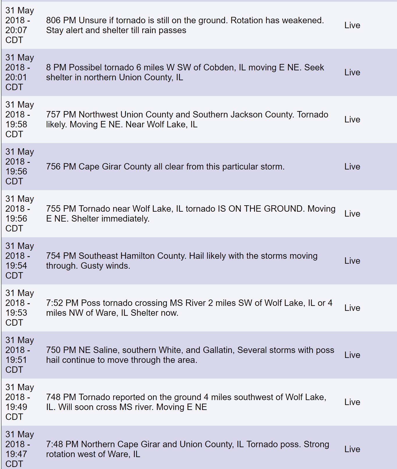
Additional storms formed late in the afternoon and evening. Some of those storms produced ping pong size hail, 70 mph winds, and even tornadoes.
At least one or two tornadoes struck northern Cape Girardeau County, Missouri, and Union County, Illinois. If you have not checked out my Twitter feed then please do so. Numerous photos of the tornadoes can be viewed there. Click here for Twitter.
Thankfully, to my knowledge, nobody was injured by the tornado.
Here were some of the text/app messages I sent out during the tornado. Reverse order.
The good news is that today won’t be active as Thursday. A calmer day ahead.
There will be some early AM storms in the Missouri Bootheel and northwest Tennessee. Isolated severe weather risk.
There is a chance of an isolated storm today. There is a chance we remain completely dry. There may be a CAP on the atmosphere today.
If a storm does form then it could produce brief downpours and gusty winds.
I am more concerned about Saturday.
Saturday will be a day that we need to keep an eye on radars. There is a lower than normal confidence level concerning how Saturday afternoon and night unfolds.
There is the potential of a squall line (line of storms) forming somewhere in the State of Missouri. The question is where?
Guidance shows two possible scenarios.
One scenario is that a complex of storms forms Friday night across northern Missouri and moves southward overnight into Saturday morning. This complex dies off before reaching most of our region. This stabilizes the atmosphere Saturday.
If that happens then the threat of severe weather diminishes.
Another scenario is that the Friday night system does not develop and our atmosphere becomes very unstable Saturday afternoon into Saturday night.
Some of the charts show 3000+ CAPE. If that happens then storms could rapidly develop in the heat of the afternoon and evening.
Storms would quickly become severe and produce large hail and damaging winds. Isolated tornadoes, as well.
At this point, I am unsure which scenario will develop. The Storm Prediction Center also is not sure.
I would recommend everyone monitor updates moving forward.
I will be updating everyone via the app and Facebook/blog.
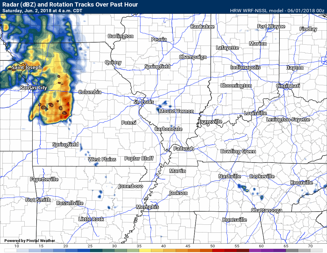
Let me show you a couple of future-cast radars.
These are different models. Which one verifies is the big question.
Notice the powerful line of storms Saturday afternoon and night.
This particular model would hit our area hard. There would be severe reports.
The timestamp is located in the upper left corner.
HRW WRF NSSEL model.
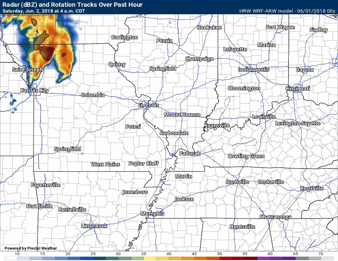
This next model is the HRW WRF-ARW
This model would hit southeast Missouri fairly hard. Uncertain on the rest of the area.
This next model is the HRW NMMB
It would bring some storms into the region. It shows the heaviest weather across Missouri and Arkansas.

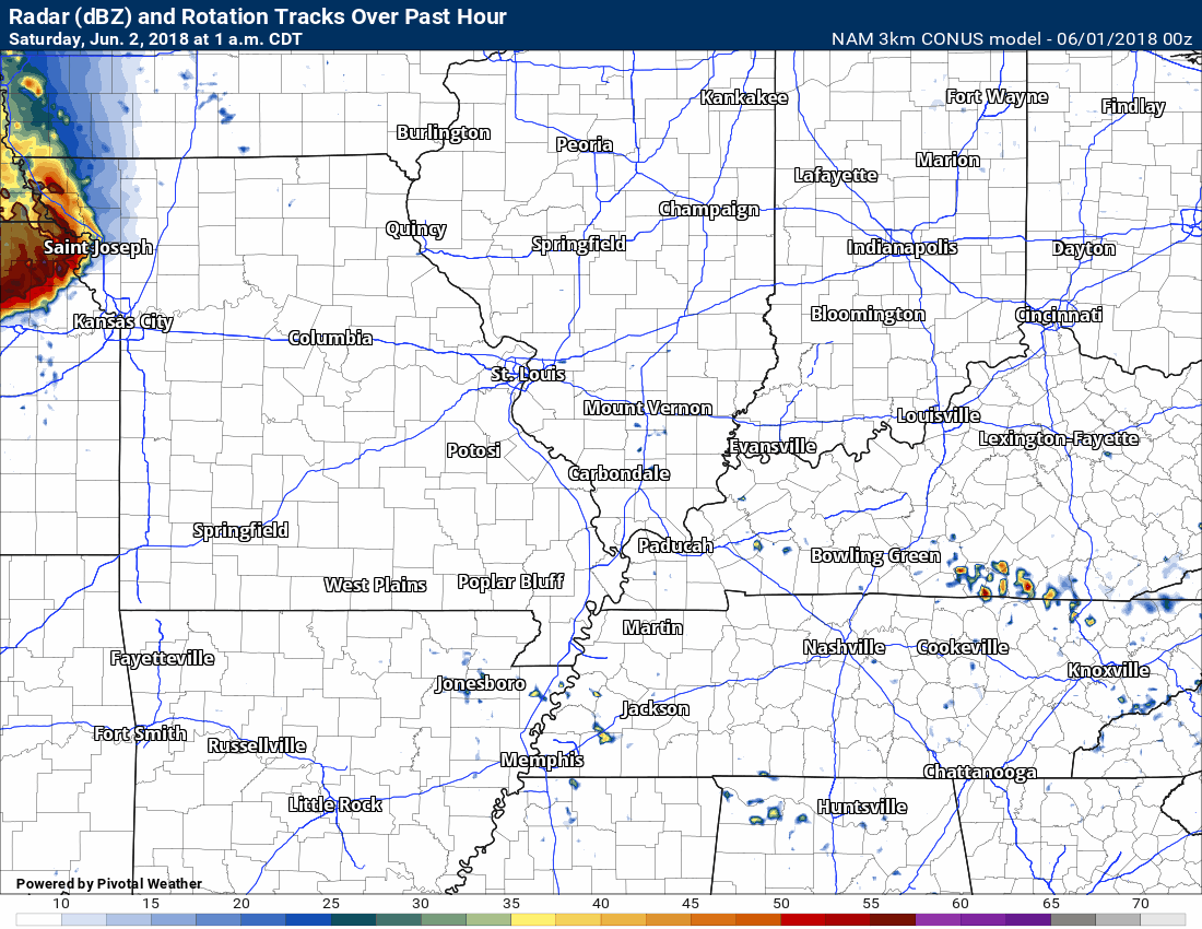
This next model is the 3K NAM
This would bring some storms into the region Saturday evening/night. It is not as intense with the line as some other models.
It would produce some severe reports in our region.
Monitor updates.
Sunday into Tuesday should be dry, a bit cooler, and less humid.

A new weather podcast is now available! Weather Geeks (which you might remember is on The Weather Channel each Sunday)
To learn more visit their website. Click here.
.![]()

WeatherBrains Episode 645
The first named storm of 2018 is now in the books, so we’re going to be talking with two experts in the area of tropical weather, Max Mayfield, left, and Bryan Norcross, right.
These two hurricane specialists currently work for WPLG in Fort Lauderdale. They both need no introduction. Max Mayfield, former Director of the National Hurricane Center, and Bryan Norcross, Mr. Hurricane who appeared on the show a few months ago when his book came out.
Max was unable to get connected to the hangout.
Other discussions in this weekly podcast include topics like:
- Extremes: 111 at Death Valley, CA, and 28 at Leadville, CO
- Alberto developed in SE Gulf and moved north through Alabama
- Humongous flooding in Ellicott City, MD
- 4 lightning deaths in US this year
- Astronomy Outlook with Tony Rice
- and more!
Previous episodes can be viewed by clicking here.

We offer interactive local city live radars and regional radars. If a radar does not update then try another one. If a radar does not appear to be refreshing then hit Ctrl F5. You may also try restarting your browser.
The local city view radars also have clickable warnings.
During the winter months, you can track snow and ice by clicking the winterize button on the local city view interactive radars.
You may email me at beaudodson@usawx.com
Find me on Facebook!

Find me on Twitter!

Did you know that a portion of your monthly subscription helps support local charity projects?
You can learn more about those projects by visiting the Shadow Angel Foundation website and the Beau Dodson News website.

I encourae subscribers to use the app vs regular text messaging. We have found text messaging to be delayed during severe weather. The app typically will receive the messages instantly. I recommend people have three to four methods of receiving their severe weather information.
Remember, my app and text alerts are hand typed and not computer generated. You are being given personal attention during significant weather events.
