We have some great sponsors for the Weather Talk Blog. Please let our sponsors know that you appreciate their support for the Weather Talk Blog.
Milner and Orr Funeral Home and Cremation Services located in Paducah, Kentucky and three other western Kentucky towns – at Milner and Orr they believe in families helping families. You can find Milner and Orr on Facebook, as well.
![]()
Check out our sponsors! There are more on the right side bar of the page, as well. Be sure and let them know that you appreciate their sponsorship of the WeatherTalk daily weather bulletin.

Wortham Dental Care located in Paducah, Kentucky. The gentle dentist. Mercury free dentistry. They also do safe Mercury removal. You can find Wortham Dental Care on Facebook, as well
.

Trover’s Equipment and Lawn Care – Family owned and operated! They are a dealer for Snapper, Simplicity, Snapper Pro, Bad Boy Mowers, and Intimidator Utility Vehicles. They are a Stihl and Dolmar power products dealer. They also are a dealer for Briggs & Stratton, Kohler gas & diesel engines, and Kawasaki engines. They service and repair just about any brand. You can find them on Facebook, as well
.

Visit their web-site here. Or, you can also visit their Facebook page.

Endrizzi’s Storm Shelters – For more information click here. Endrizzi Contracting and Landscaping can be found on Facebook, as well – click here
Are you looking for a full service insurance agency that writes homes, businesses, and vehicles in Illinois, Kentucky, and Tennessee. Call Gary’s office at 270.442.8234 for rates and plans to protect what matters to you!

Gary Eckelkamp’s web-site click the above banner or click here

This forecast update covers far southern Illinois, far southeast Missouri, and far western Kentucky. See the coverage map on the right side of the blog.
Remember that weather evolves. Check back frequently for updates, especially during active weather.
The forecast numbers below may vary a bit across the region. These are the averages.
WEATHER RADAR PAGE – Click here —
Monday night – Partly cloudy in the evening with a slight chance for a shower or thunderstorm. Partly cloudy late with a few thunderstorms developing from the southwest and moving northeast.
Temperatures: Lows in the 60’s to lower 70’s.
Winds: South and southwest winds at 5-10 mph. If storms occur then there would be gusty winds near them.
My confidence in this part of the forecast verifying is high
Should I cancel my outdoor plans? No
Is severe weather expected? No
What is the chance for precipitation? 20% before 9 pm and then 30%-40% late.
What impact is expected? If storms occur then lightning and a heavy downpours possible. Avoid flooded roadways in case flooding develops.
Tuesday – Flash flood watch. Flooding continues to be a concern. Partly to mostly cloudy. An 80% chance for showers and thunderstorms. Heavy rain possible where storms occur. Avoid flooded roadways. This will depend on how far south and east the cold front swings. We will have to see how far south the fronts sags.
Temperatures: Highs from 80 to 85 degrees
Winds: West and southeast winds at 5-10 mph. A gust to 15 mph possible. Winds would be gustier near storms, of course.
My confidence in this part of the forecast verifying is medium
Should I cancel my outdoor plans? I would have a back up plan.
What is the chance for precipitation? 80% chance
What impact is expected? Storms could produce lightning, heavy rain, and gusty winds. Flash flooding is always a concern this time of the year with slow moving thunderstorms or training.
Tuesday night – Flash flood watch. Cloudy. Showers and thunderstorms possible. Locally heavy rain possible.
Temperatures: Lows in the 60’s to lower 70’s.
Winds: South and southwest winds at 5-10 mph. Winds would be gustier near storms, of course.
My confidence in this part of the forecast verifying is medium
Should I cancel my outdoor plans? Monitor radars and have a back up plan in mind.
Is severe weather expected? Minimal risk.
What is the chance for precipitation? 60%-70% chance over southeast MO and southern IL. 50%-60% elsewhere.
What impact is expected? Where storms occur then lightning and a heavy downpour possible. Gusty winds.
Wednesday – Flash flood watch. Partly sunny. Not as warm. A chance for thunderstorms. Where storms occur there could be locally heavy rainfall totals. Best chances on Wednesday might again be over southeast Missouri and southern Illinois vs Kentucky and Tennessee. This will depend on the placement of the cold front. Models are not in agreement as to how far south the front pushes.
Temperatures: Highs from 80 to 85 degrees
Winds: Variable winds in the area. South of the front we will have southwest winds. North of the front there will be east and southeast winds at 5-10 mph. Winds would be gustier near storms, of course.
My confidence in this part of the forecast verifying is medium
Should I cancel my outdoor plans? Have a back up plan.
What is the chance for precipitation? 40%-50% chance (best chances for Missouri and Illinois)
What impact is expected? Storms could produce lightning, heavy rain, and gusty winds
Wednesday night – Partly cloudy. A few scattered thunderstorms still possible.
Temperatures: Lows in the upper 60’s to lower 70’s.
Winds: South and southwest winds at 5-10 mph.
My confidence in this part of the forecast verifying is medium
Should I cancel my outdoor plans? I can’t rule out a storm, but scattered in nature.
Is severe weather expected? Minimal risk.
What is the chance for precipitation? 30% chance
What impact is expected? Where storms occur then lightning and a heavy downpour possible. Gusty winds.
Thursday – Partly cloudy with a few scattered storms possible. Warm and humid.
Temperatures: Highs from 84 to 88 degrees
Winds: South and southwest winds at 5-10 mph.
My confidence in this part of the forecast verifying is medium
Should I cancel my outdoor plans? Should be okay. Just small chances for storms.
What is the chance for precipitation? 20% chance
What impact is expected? Lightning would be the main concern if a storm forms.
Right now it appears Friday into Sunday will be mostly sunny to partly sunny. I believe rain chances will be less than 10% for that time period. Warm/hot. Highs perhaps into the lower 90’s.
Rain chances might return by Monday or Tuesday.
![]()
Sunrise and Sunset Times – Click Here


Don’t forget to check out the Southern Illinois Weather Observatory web-site for weather maps, tower cams, scanner feeds, radars, and much more! Click here

An explanation of what is happening in the atmosphere over the coming days…
Highlights
1. Showers and thunderstorms are back in the forecast
2. Heavy rain potential for at least parts of the region. Flash flooding a big concern.
3. I have some advertiser or sponsorship spots available on the blog and on Facebook. Contact me for details at beaudodson@usawx.com
Well, we just can’t shake the showers and thunderstorms. The past few weeks (and 2 months for some) have been quite wet. Now, a few of you have somehow managed to miss out on the the big rain events. But, you are the minority. Parts of our region have experienced 200%-400% of normal precipitation.
More heavy rain is in the forecast for some of my forecast counties. Flash flooding is a concern, but with a setup like this you never really know where. Heavy rains can fall in small locations and produce big problems. Keep this in mind.
My forecast for July was for at least half the month to be in NW flow. So far we have had 5 days in northwest flow. We will briefly move more towards a southwest flow aloft and then return back to northwest flow. Remember, northwest flow typically keeps our region wet and cooler than normal.
A cold front is moving into the region from the north and west. This front will advance into southeast Missouri and southern Illinois on Tuesday. It will then stall out in the area until Thursday. On Thursday it will return north as a warm front. Once that happens we will heat up again.
The region has been experiencing northwest flow for about the last 2 weeks. The northwest flow brought below normal temperatures. It is quite rare to have 2 weeks of below normal temperatures in the summer.
Showers and thunderstorms will accompany the stalled front over the coming days. Some of the rain will be heavy. Rainfall totals of 1-3″ are likely over parts of southeast Missouri and southern Illinois. Western Kentucky, as well. Some places will pick up more than 3″ of rain. Perhaps 4-6″ in spots.
There is some debate on the placement of heavy rain. I did see a few data sets that showed the heaviest totals from southeast Missouri into western Kentucky. But, the majority of data has the heavier rain a tad north of there.
With this type of air-mass we could see some heavy totals just about anywhere thunderstorms occur. Keep that in mind. I am sure there will be some heavy totals over western Kentucky and western Tennessee, as well. And, where this occurs flash flooding can quickly develop from slow moving storms. Without much warning.
Here is one map showing you potential rainfall totals. Again, totals will vary.
This map isn’t gospel 🙂 It is a general idea of placement of the heavier rain totals. Use it as guidance.

Flash flooding once again can’t be ruled out. And, remember...you do not need a warning from the NWS to experience problems. Many many of our counties had flooding problems last week without advisories or warnings. If you see a flooded roadway then avoid it. One person was killed in western Kentucky last week because they drove into flood waters.
The saying is “turn around, don’t drown”
The front will meander around our region until Thursday. At that point it should move back north. Perhaps even as early as Wednesday afternoon and night. Either way…showers and storms will continue to be in the forecast into Thursday.
Friday into the weekend should warm back up to near seasonal temperatures and maybe a bit above normal. We will see.
Severe weather?
Although I can’t completely rule out an isolated severe thunderstorm, overall it appears the risk is minimal. Bigger concern will be additional heavy rain over parts of our region.
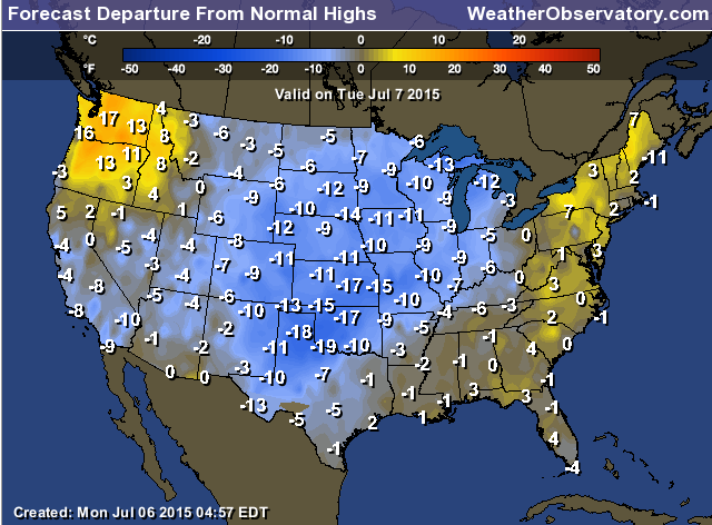
Let’s once again check out the temperature anomalies for Monday. Normal to slightly below normal? Will be close. These are high temperature departures. Look what is coming in from the northwest behind that next cold front. How far will the front push? That is the question.
These numbers represent how many degrees above or below normal temperatures will be on Tuesday (temperatures have been below normal for two weeks…quite amazing for summer)

This section of the blog is speculative forecast information. Because it is past the range of what meteorologists can forecast accurately, it should be considered speculation. Anything past day 5 is considered a long range forecast.
Highlights
1. What about the third and fourth week of July?
2. Time to heat back up!
3. Will the northwest flow return?
All of the data is pointing towards the ridge of high pressure building back into our region late this week into the weekend. What does that mean? It means that after two weeks of below normal temperatures (and northwest flow) it is time to return to a normal summer pattern.
Temperatures will be on the rise by Friday into the weekend. Humidity will also be present. It will feel like summer. Not sure how long the ridge will last. I will crunch some data once we move this cold front out of the region. But, at least for awhile the ridge is going to once again win (this happened the second and third weeks of June). So, not surprised to see it return. We could not remain below normal forever! It is still summer.
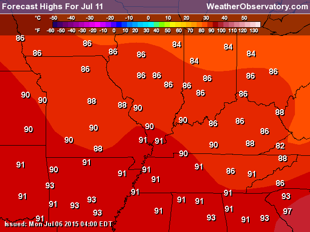
Here is the high temperature forecast for Saturday. Fun at the lake?
We might play a bit of a tug of war between the ridge and troughs over the coming 2-4 weeks. I do see some fairly significant heat in August, as well.
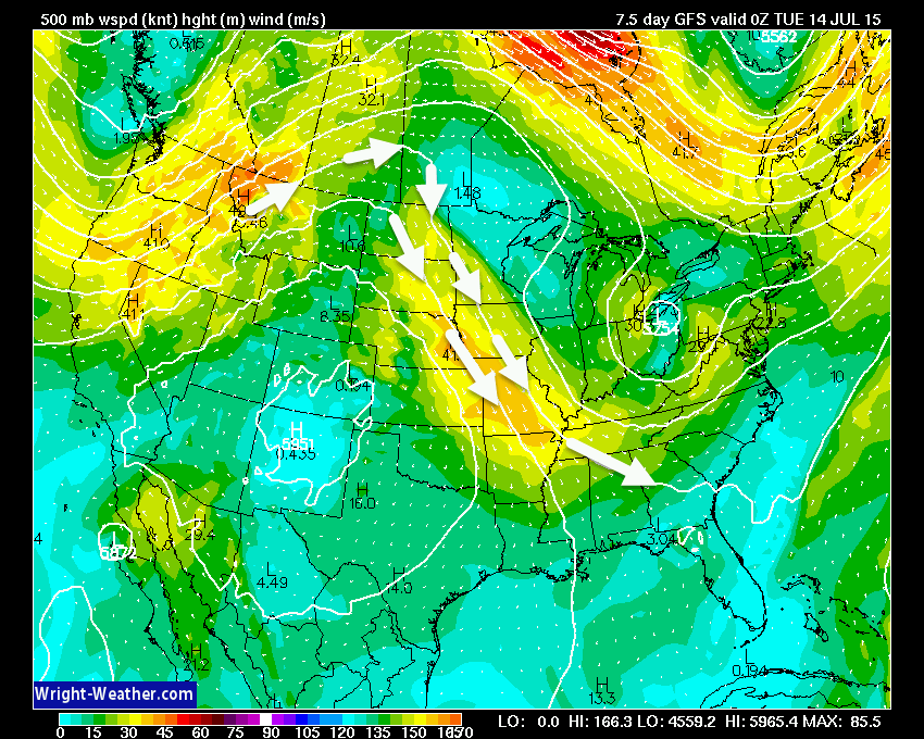
I pulled up the GFS model to show you the flow over the coming week.
Here is Wednesday. A bit more of a zonal look to the flow aloft.
Zonal is when winds aloft are more west to east. Northwest flow is when the arrows (wind) are coming in from the northwest.

Here is the Sunday outlook. See the high pressure? That is the ridge of high pressure that normally builds into our region during summer.
The ridge of high pressure typically means hot weather. This weekend we will see the ridge return. At least for a couple of days.

And finally, let’s pull ahead to next week. BACK to northwest flow! At least for a few days. We will see how long that will last. Once again that would mean active weather. I think we have had plenty of rain (most of us, at least)
If the above map is correct then next Monday into Wednesday could again be stormy and wet.
Radars
WEATHER RADAR PAGE – Click here —

I also set up a storm tracking page with additional links (use during active weather for quick reference)
Storm Tracking Tool Page
Don’t forget to support our sponsors!

How much precipitation should we expect over the next few days?
As we enter the late spring and summer months, keep in mind that slow moving thunderstorms can always produce locally heavy rainfall totals. This is no secret to all of you who are farmers. Your neighbors could pick up 1″ of rain from a thunderstorm, meanwhile you are sitting on dry ground. Forecasting exact rainfall totals during this time of the year can be tricky, at best
Tuesday into Thursday will bring better rain chances with pockets of 1-3″+ again possible. Same as this past week. Some places will end up with a lot of rain. Flash flooding is a concern, again.
Here is the official rainfall forecast (broad-brushed) for the upcoming week. Most of this falls from TUE into THUR
There was a little shift northward for the heavier rain totals. This is because of the front stalling out before it reaches too far into Kentucky and Tennessee. Image is from weatherbell.com
Click the image to view a larger size.
You can see the sharp gradient on this map.


Can we expect severe thunderstorms over the next 24 to 48 hours? Remember that a severe thunderstorm is defined as a thunderstorm that produces 58 mph winds or higher, quarter size hail or larger, and/or a tornado.
Thunderstorm threat level is a ONE on Monday night and a TWO on Tuesday.
Tuesday Severe Weather Outlook – Storms are likely, but most should remain below severe levels.
Wednesday Severe Weather Outlook – Storms are likely in the area. Severe weather risk is minimal.
Thursday Severe Weather Outlook – Thunderstorms are possible, but should remain below severe levels.
Friday Severe Weather Outlook – Severe weather is not anticipated
Saturday Severe Weather Outlook – Severe weather is not anticipated
Sunday Severe Weather Outlook – Severe weather is not anticipated


A few storms over the coming days. Of course, lightning is always a concern for outdoor events. There will also be some locally heavy rainfall amounts. The ground is saturated. I can’t rule out flooding in some areas if storms train over the same areas. Some rainfall amounts may exceed 3 inches. This is especially true over southeast Missouri and southern Illinois. I can’t completely rule it out over western Kentucky and Tennessee, but the better chances will be north vs south.
Avoid flooded roadways. Flash flooding may occur with this type of patter.
The severe weather threat will be minimal. Gusty winds possible in and near storms. Small chance for small hail.
Rivers will remain high.

Here are the current river stage forecasts. You can click your state and then the dot for your location. It will bring up the full forecast and hydrograph.
Click Here For River Stage Forecasts…
Here are some current forecast hydrographs. These will be updated each day with new information.


Smithland Lock and Dam

Paducah, Kentucky Forecast Stage

Cairo, Illinois

Cape Girardeau, Missouri
Current Temperatures Around The Local Area


We have regional radars and local city radars – if a radar does not seem to be updating then try another one. Occasional browsers need their cache cleared. You may also try restarting your browser. That usually fixes the problem. Occasionally we do have a radar go down. That is why I have duplicates. Thus, if one fails then try another one.
If you have any problems then please send me an email beaudodson@usawx.com
WEATHER RADAR PAGE – Click here —
We also have a new national interactive radar – you can view that radar by clicking here.
Local interactive city radars include St Louis, Mt Vernon, Evansville, Poplar Bluff, Cape Girardeau, Marion, Paducah, Hopkinsville, Memphis, Nashville, Dyersburg, and all of eastern Kentucky – these are interactive radars. Local city radars – click here
NOTE: Occasionally you will see ground clutter on the radar (these are false echoes). Normally they show up close to the radar sites – including Paducah.

Regional Radar – Click on radar to take you our full radar page.


Regional Radar

Live Lightning Data – zoom and pan: Click here
Live Lightning Data with sound (click the sound button on the left side of the page): Click here
I also set up a storm tracking page with additional links (use during active weather for quick reference)
Storm Tracking Tool Page
![]()
Current WARNINGS (a warning means take action now). Click on your county to drill down to the latest warning information. Keep in mind that there can be a 2-3 minute delay in the updated warning information.
I strongly encourage you to use a NOAA Weather Radio or warning cell phone app for the most up to date warning information. Nothing is faster than a NOAA weather radio.


Color shaded counties are under some type of watch, warning, advisory, or special weather statement. Click your county to view the latest information.

Missouri Warnings

Illinois Warnings

Kentucky Warnings

Here is the official 6-10 day and 8-14 day temperature and precipitation outlook. Check the date stamp at the top of each image (so you understand the time frame).
The forecast maps below are issued by the Weather Prediction Center (NOAA).


The latest 8-14 day temperature and precipitation outlook. Note the dates are at the top of the image. These maps DO NOT tell you how high or low temperatures or precipitation will be. They simply give you the probability as to whether temperatures or precipitation will be above or below normal.


Who do you trust for your weather information and who holds them accountable?
I have studied weather in our region since the late 1970’s. I have 37 years of experience in observing our regions weather patterns. My degree is in Broadcast Meteorology from Mississippi State University and an Associate of Science (AS). I am currently working on my Bachelor’s Degree in Geoscience. Just need to finish two Spanish classes!
I am a member of the American Meteorological Society. I am a NOAA Weather-Ready Nation Ambassador. And, I am the Meteorologist for McCracken County Emergency Management.
I own and operate the Southern Illinois Weather Observatory.
There is a lot of noise on the internet. A lot of weather maps are posted without explanation. Over time you should learn who to trust for your weather information.
My forecast philosophy is simple and straight forward.
- Communicate in simple terms
- To be as accurate as possible within a reasonable time frame before an event
- Interact with you on Twitter, Facebook, and the blog
- Minimize the “hype” that you might see on television or through other weather sources
- Push you towards utilizing wall-to-wall LOCAL TV coverage during severe weather events
I am a recipient of the Mark Trail Award, WPSD Six Who Make A Difference Award, Kentucky Colonel, and the Caesar J. Fiamma” Award from the American Red Cross. In 2009 I was presented with the Kentucky Office of Highway Safety Award. I was recognized by the Kentucky House of Representatives for my service to the State of Kentucky leading up to several winter storms and severe weather outbreaks.
If you click on the image below you can read the Kentucky House of Representatives Resolution.

I am also President of the Shadow Angel Foundation which serves portions of western Kentucky and southern Illinois.
Many of my graphics are from www.weatherbell.com – a great resource for weather data, model data, and more


You can sign up for my AWARE email by clicking here I typically send out AWARE emails before severe weather, winter storms, or other active weather situations. I do not email watches or warnings. The emails are a basic “heads up” concerning incoming weather conditions.