We have some great sponsors for the Weather Talk Blog. Please let our sponsors know that you appreciate their support for the Weather Talk Blog.
Milner and Orr Funeral Home and Cremation Services located in Paducah, Kentucky and three other western Kentucky towns – at Milner and Orr they believe in families helping families. You can find Milner and Orr on Facebook, as well.
![]()
.

For all of your families eye care needs. Visit their web-site here. Or, you can also visit their Facebook page.
.

Best at Enabling Body Shop Profitability since 1996. Located In Paducah Kentucky and Evansville Indiana; serving all customers in between. They provide Customer Service, along with all the tools necessary for body shops to remain educated and competitive. Click the logo above for their main web-site. You can find McClintock Preferred Finishes on Facebook, as well

Expressway Carwash and Express Lube are a locally owned and operated full service Carwash and Lube established in 1987. We have been proudly serving the community for 29 years now at our Park Avenue location and 20 years at our Southside location. We have been lucky enough to partner with Sidecar Deli in 2015, which allows us to provide our customers with not only quality service, but quality food as well. . If you haven’t already, be sure to make Expressway your one stop shop, with our carwash, lube and deli. For hours of operation and pricing visit www.expresswashlube.com or Expressway Carwash on Facebook.

TORNADO SHELTERS! Endrizzi’s Storm Shelters – For more information click here. Endrizzi Contracting and Landscaping can be found on Facebook, as well – click here
I have launched the new weather texting service! I could use your help. Be sure and sign up and fully support all of the weather data you see each day.
This is a monthly subscription service. Supporting this helps support everything else. The cost is $3 a month for one phone, $5 a month for three phones, and $10 a month for seven phones.
For more information visit BeauDodsonWeather.com
Or directly sign up at Weathertalk.com


This forecast update covers far southern Illinois, far southeast Missouri, and far western Kentucky. See the coverage map on the right side of the blog.
Remember that weather evolves. Check back frequently for updates, especially during active weather.

Friday Night – Partly cloudy. Showers and scattered thunderstorms.
What impact is expected? Wet roadways and perhaps lightning.
Temperatures: Lows in the 63-66 degree range
Winds: Winds variable at 5-10 mph. Higher near storms.
What is the chance for precipitation? 60%
Coverage of precipitation: Scattered
Is severe weather expected? No, but if storms form they could produce frequent lightning and gusty winds.
My confidence in this part of the forecast verifying is High
Should I cancel my outdoor plans? No, but monitor radars
.
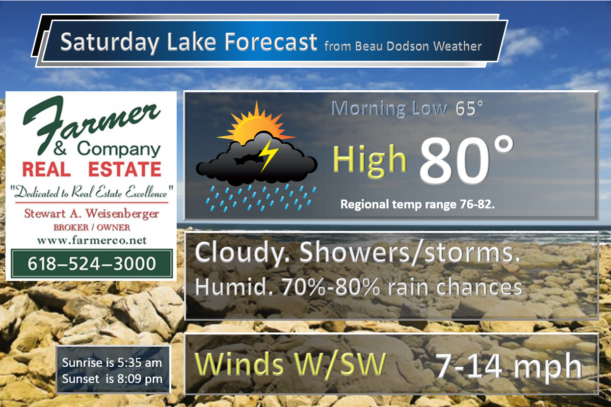
Saturday. – Quite a few clouds. Showers and thunderstorms likely. Some storms will produce frequent lightning, heavy rain, and gusty winds.
What impact is expected? Wet roadways and lightning. Heavy rain possible. Gusty winds near storms. Small chance for hail.
Temperatures: High temperatures in the 76-82 degree range.
Winds: West and southwest winds at 7-14 mph. Gusts to 15 mph. Higher near storms.
What is the chance for precipitation? 70%-80%
Coverage of precipitation? Numerous to widespread coverage
Is severe weather expected? A few storms could produce strong winds and small hail. Lightning and heavy downpours are the primary concern. There is a small risk of a few storms becoming severe.
My confidence in this part of the forecast verifying is High
Should I cancel my outdoor plans? Have a solid plan B.
Saturday Night – Partly to mostly cloudy. A shower or thunderstorm possible, especially before 10 pm.
What impact is expected? Wet roadways and lightning.
Temperatures: Lows in the 62-66 degree range
Winds: Winds southwest and west at 5-10 mph. Gusty near storms.
What is the chance for precipitation? 50% before 10 pm. 40% after 10 pm. 30% after 2 am. Decreasing chances through the night.
Coverage of precipitation: Ending from west to east
Is severe weather expected? A few evening storms could produce gusty winds and small hail.
My confidence in this part of the forecast verifying is High
Should I cancel my outdoor plans? No, but have a plan B for the early evening hours. Hopefully the rain will end by evening.
.
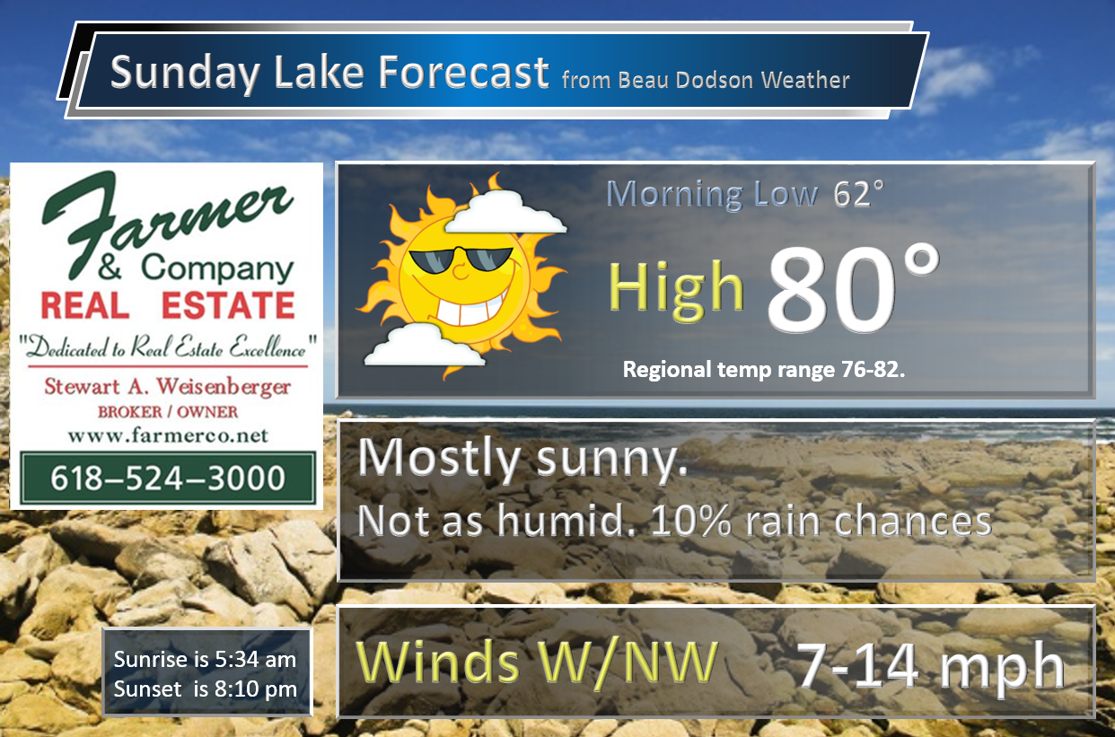
Sunday. – Mostly sunny during the morning. Perhaps some afternoon puffy clouds. Cooler. Small chance for a shower or two. Not as humid.
What impact is expected? Small chance for wet roads and lightning. Mainly over the Pennyrile area of western Kentucky.
Temperatures: High temperatures in the 76-82 degree range.
Winds: West and northwest winds at 8-16 mph. Gusty at times.
What is the chance for precipitation? 20%
Coverage of precipitation? Isolated
Is severe weather expected? No
My confidence in this part of the forecast verifying is High
Should I cancel my outdoor plans? No
Sunday Night – Partly cloudy. Cool. Less humid.
What impact is expected? None
Temperatures: Lows in the 58-64 degree range
Winds: Winds northwest at 5-10 mph.
What is the chance for precipitation? 0%
Coverage of precipitation: None.
Is severe weather expected? No
My confidence in this part of the forecast verifying is High
Should I cancel my outdoor plans? No
.
Monday. – Mostly sunny during the morning. Perhaps some afternoon puffy clouds.
What impact is expected? None.
Temperatures: High temperatures in the 76-84 degree range.
Winds: West winds at 7-14 mph.
What is the chance for precipitation? 0%
Coverage of precipitation? None.
Is severe weather expected? No
My confidence in this part of the forecast verifying is High
Should I cancel my outdoor plans? No
Monday Night – Increasing clouds from the north. Less humid. Nice.
What impact is expected? None
Temperatures: Lows in the 58-64 degree range
Winds: Winds west at 5 mph.
What is the chance for precipitation? 0%
Coverage of precipitation: None.
Is severe weather expected? No
My confidence in this part of the forecast verifying is High
Should I cancel my outdoor plans? No
.
Tuesday. A few clouds. Otherwise, quite a bit of sun. Small chance for thunderstorms.
What impact is expected? Most likely none. I will be monitoring a storm system to our north.
Temperatures: High temperatures in the 78-84 degree range.
Winds: Northwest winds at 6-18-16 mph and gusty at times.
What is the chance for precipitation? 20%
Coverage of precipitation? None to isolated.
Is severe weather expected? No
My confidence in this part of the forecast verifying is Medium
Should I cancel my outdoor plans? No
Tuesday Night – Clearing. Nice.
What impact is expected? None
Temperatures: Lows in the 55-60 degree range
Winds: Winds north/northwest at 5 mph.
What is the chance for precipitation? 0%
Coverage of precipitation: None.
Is severe weather expected? No
My confidence in this part of the forecast verifying is High
Should I cancel my outdoor plans? No
.
Wednesday. – Mostly sunny. Afternoon cumulus clouds.
What impact is expected? None
Temperatures: High temperatures in the 76-82 degree range
Winds: Northeast winds at 6-12 mph
What is the chance for precipitation? 0%
Coverage of precipitation? None
Is severe weather expected? No
My confidence in this part of the forecast verifying is High
Should I cancel my outdoor plans? No
Wednesday Night – Mostly clear.
What impact is expected? None
Temperatures: Lows in the 58-64 degree range
Winds: Winds variable at 5-10 mph.
What is the chance for precipitation? 0%
Coverage of precipitation: None
Is severe weather expected? No
My confidence in this part of the forecast verifying is High
Should I cancel my outdoor plans? No
.
Thursday. – A mix of sun and clouds. More humid.
What impact is expected? None to isolated
Temperatures: High temperatures in the 82-86 degree range
Winds: South winds at 6-12 mph
What is the chance for precipitation? 10%
Coverage of precipitation? Isolated
Is severe weather expected? No
My confidence in this part of the forecast verifying is High
Should I cancel my outdoor plans? No
Thursday Night – Partly cloudy
What impact is expected?
Temperatures: Lows in the 64-68 degree range
Winds: Winds southwest at 5-10 mph.
What is the chance for precipitation? 10%
Coverage of precipitation: Isolated
Is severe weather expected? No
My confidence in this part of the forecast verifying is High
Should I cancel my outdoor plans? No
.
Friday. – A mix of sun and clouds. Warm. Humid.
What impact is expected?
Temperatures: High temperatures in the 84-88 degree range
Winds: Southwest winds at 7-14 mph. Gusts to 20 mph.
What is the chance for precipitation? 20%
Coverage of precipitation? Isolated
Is severe weather expected? No
My confidence in this part of the forecast verifying is Medium
Should I cancel my outdoor plans? No
Friday Night – Partly cloudy. Warm.
What impact is expected? None
Temperatures: Lows in the 68-72 degree range
Winds: Winds variable at 5-10 mph.
What is the chance for precipitation? 10%
Coverage of precipitation: Isolated
Is severe weather expected? No
My confidence in this part of the forecast verifying is Medium
Should I cancel my outdoor plans? No
.
Saturday. – Partly cloudy.
What impact is expected?
Temperatures: High temperatures in the 84-88 degree range
Winds: Southwest winds at 7-14 mph with gusts to 20 mph.
What is the chance for precipitation? 10% (long way off. Probabilities always start smaller and increase as confidence grows).
Coverage of precipitation?
Is severe weather expected?
My confidence in this part of the forecast verifying is Low
Should I cancel my outdoor plans?
Saturday Night – Partly cloudy.
What impact is expected?
Temperatures: Lows in the 66-72 degree range
Winds: Winds variable at 5-10 mph.
What is the chance for precipitation? 10%
Coverage of precipitation:
Is severe weather expected?
My confidence in this part of the forecast verifying is Low
Should I cancel my outdoor plans?
.
Sunday. – Partly sunny.
What impact is expected?
Temperatures: High temperatures in the 84-88 degree range
Winds: Southwest winds at 7-14 mph. Gusty.
What is the chance for precipitation?
Coverage of precipitation?
Is severe weather expected?
My confidence in this part of the forecast verifying is Low
Should I cancel my outdoor plans?
Sunday Night – Partly cloudy. A thunderstorm possible.
What impact is expected?
Temperatures: Lows in the 66-72 degree range
Winds: Winds variable at 5-10 mph.
What is the chance for precipitation? 0%
Coverage of precipitation:
Is severe weather expected?
My confidence in this part of the forecast verifying is Low
Should I cancel my outdoor plans?
.
Monday. – Partly sunny. A thunderstorm possible.
What impact is expected?
Temperatures: High temperatures in the 84-86 degree range
Winds: Southwest winds at 7-14 mph
What is the chance for precipitation?
Coverage of precipitation?
Is severe weather expected?
My confidence in this part of the forecast verifying is Low
Should I cancel my outdoor plans?
Monday Night – Partly cloudy.
What impact is expected?
Temperatures: Lows in the 64-68 degree range
Winds: Winds variable at 5-10 mph.
What is the chance for precipitation?
Coverage of precipitation:
Is severe weather expected?
My confidence in this part of the forecast verifying is Low
Should I cancel my outdoor plans?
.
Tuesday. – Partly sunny. Warm.
What impact is expected?
Temperatures: High temperatures in the 84-86 degree range
Winds: Southwest winds at 7-14 mph
What is the chance for precipitation?
Coverage of precipitation?
Is severe weather expected?
My confidence in this part of the forecast verifying is Low
Should I cancel my outdoor plans?
Tuesday Night – Partly cloudy.
What impact is expected?
Temperatures: Lows in the 64-68 degree range
Winds: Winds variable at 5-10 mph.
What is the chance for precipitation?
Coverage of precipitation:
Is severe weather expected?
My confidence in this part of the forecast verifying is Low
Should I cancel my outdoor plans?
.
The weekend forecast is sponsored by Farmer and Company Real Estate.

Farmer & Company Real Estate is proud to represent buyers and sellers in both Southern Illinois and Western Kentucky. With 13 licensed brokers, we can provide years of experience to buyers & sellers of homes, land & farms and commercial & investment properties. We look forward to representing YOU! Follow us on Facebook, as well
The weekend forecast is sponsored by Farmer and Company Real Estate. Click here to visit their site.


Don’t forget to check out the Southern Illinois Weather Observatory web-site for weather maps, tower cams, scanner feeds, radars, and much more! Click here

An explanation of what is happening in the atmosphere over the coming days…
- Have a plan B for Saturday. Rain is likely to occur in the region.
- Dry weather Sunday (small chance Sunday) through perhaps Thursday!
- Another chance for storms next Friday night or Saturday (low confidence this far out)
- Active the week of the 12th-18th?
Want to see what lightning looks like in slow motion?
And now, the weather forecast summary
Welcome to the weekend! The first full weekend of meteorological summer. Remember, meteorologists measure the seasons a little bit different than everyone else. We consider summer to be June, July, and August. Normally the weather behaves that way, as well.
We have one more solid day of precipitation chances. Then, a BREAK! Everyone say, THANK YOU! I will same the same. We deserve a break from the day after day after day of thunderstorm chances. And, a break is what we should have next week.
First, we have to get through Saturday and Saturday night.
Many of you have been watching the sad news out of Texas. A number of people have died because of flooding. Many people have lost everything in the severe flooding. The system that has been producing our rain is connected to that one. And, the Texas system will finally push northeast on Saturday. I know Texas will be glad to see it leave.
The end result for our region will be thunderstorm chances from Friday night into Saturday night. The highest concentration of showers and thunderstorms will be on Saturday. Expect numerous showers and thunderstorms. It may not rain all day. But, there will be a high enough precipitation chance to warrant your attention. Especially true if you are participating in some of the outdoor festivals, weddings, and yard sales. Have a solid plan B. The same thing I have been telling you all week. Have a plan B. Then, hope for the best.
A few remaining showers or thunderstorms are possible on Sunday. Mainly over our eastern counties. The chances won’t be great. But, a couple of storms might form. Most of the region will remain dry. And, perhaps a bit less humid.
- Some data shows thunderstorms on Tuesday. This is because of a disturbance moving in from the north. I think, at this time, most of the precipitation will stay to our north and east. If the system shifts a bit further southwest then thunderstorms would be possible in our area. I will be monitoring this wrinkle in the dry forecast.
I am anticipating a dry streak from Sunday through at least Thursday (and maybe Friday). There are a couple of very weak disturbances that will move through the northwest flow. Those could deliver some clouds. But, I believe the best chance for showers or thunderstorms will remain to our northeast. Northwest flow means that jet stream will be diving in from the northwest. Normally that means less humid and cooler weather for our region.
We have a lot of moisture in the ground. That might keep dew points higher. If that occurs then the air might feel a bit more humid. Especially on warm afternoons. Heat index values are a bit higher when dew points increase.
Hot weather is possible by Thursday or Friday. Briefly. I consider hot to be 90 degrees or above. Can we reach 90 degrees later this week? There is at least a chance.
I am watching for a possible cold front next weekend. Low confidence. Still in the long range part of the guidance.
There is a lot of debate about the summer forecast. Many summer long range forecasts are calling for drought and heat. But, at this point, nature is not buying into that. Will that continue to be the case?
Typically we start experiencing MCS’s. These are large thunderstorm masses that form to our west and northwest. They then move over the Missouri and Ohio Valleys. Each year the track is a little bit different. This depends on where the jet stream sets up shop. MCS’s can bring a lot of rain and some severe weather. This is one item I will be monitoring over the coming weeks.
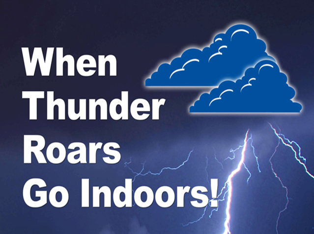
Storms have been prolific lightning producers over the last few days. Cloud to ground lightning will be a concern for outdoor activities. Keep that in mind. See the live lightning tracker in the link section (scroll down).
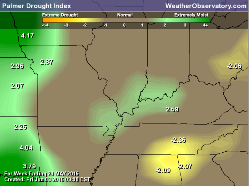
The Palmer Drought Index indicates that our region is wet. No secret on that subject.
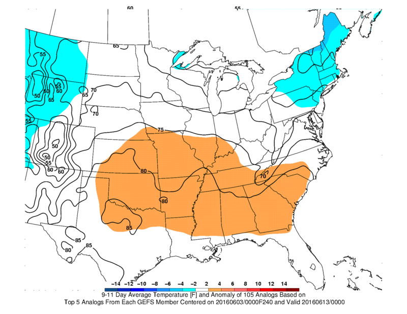
I occasionally like to look at the CIPPS analogs. Analogs are years that resembled the current weather pattern. The long range analog models attempt to guess at what might happen based on previous years.
The analogs are showing warmer than normal temperatures for this coming Friday-Monday. And, they are showing the potential for thunderstorms in or near our region. They have the higher chances on June 13th to our north. But, we have at least some storm chances Friday night into Monday, as well. Long way off in the weather world.
I am discussing next Friday-Monday (June 11th-13th)
Here are the analog forecast maps. This first one is for temperatures. The brown/orange color indicates that odds favor above normal temperatures.
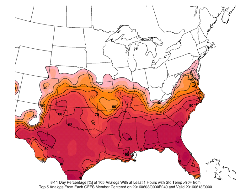
This next map is for the probabilities of temperatures reaching 90 degrees or above for at least one hour. This map would be for next weekend into Monday.
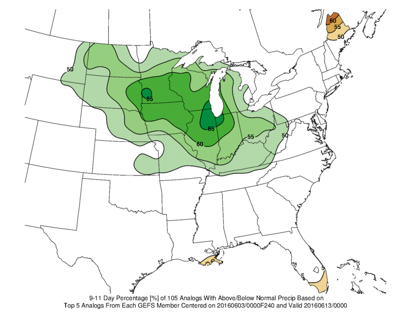
This next map shows where precipitation will most likely occur.
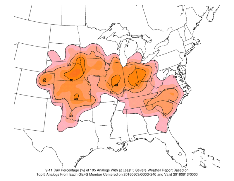
And, this last map shows where some of the storms could be intense. Again, this would be for next weekend into the early part of the following week.
Rain or shine, have a nice weekend.
Radar


We have regional radars and local city radars – if a radar does not seem to be updating then try another one. Occasional browsers need their cache cleared. You may also try restarting your browser. That usually fixes the problem. Occasionally we do have a radar go down. That is why I have duplicates. Thus, if one fails then try another one.
If you have any problems then please send me an email beaudodson@usawx.com
WEATHER RADAR PAGE – Click here —
We also have a new national interactive radar – you can view that radar by clicking here.
Local interactive city radars include St Louis, Mt Vernon, Evansville, Poplar Bluff, Cape Girardeau, Marion, Paducah, Hopkinsville, Memphis, Nashville, Dyersburg, and all of eastern Kentucky – these are interactive radars. Local city radars – click here

Live Lightning Data – zoom and pan: Click here
Live Lightning Data with sound (click the sound button on the left side of the page): Click here

Can we expect severe thunderstorms over the next 24 to 48 hours? Remember that a severe thunderstorm is defined as a thunderstorm that produces 58 mph winds or higher, quarter size hail or larger, and/or a tornado.
.
Friday night: A few storms possible on Friday night. Lightning is the main concern.
Saturday: Thunderstorms likely. Lightning is the main concern. A couple of storms could be on the strong side with gusty winds and hail. There is a small threat for a severe thunderstorm.
Sunday: Severe weather is not anticipated.
Monday: Severe weather is not anticipated.
Tuesday-Friday: Severe weather is not anticipated.
Saturday: Thunderstorms will be possible.
.

.
No major changes
.

.
A couple of concerns for the next few days. The first concern will be thunderstorms with frequent lightning and heavy downpours. The atmosphere has a lot of moisture for thunderstorm to work with. PWAT values are near the top of the chart for this time of the year. Downpours could produce 1-3″ of rain per hour. Slow moving storms will be a concern. Isolated flash flooding can’t be ruled out.
The next concern will be cloud to ground lightning. Thunderstorms, over the last few days, have produced frequent lightning. Anyone with outdoor events should monitor radars and lightning data links.
If you have plans on Friday or Saturday then have a back up plan. Especially true for Saturday. It might not rain all day, but there will be storms on radar.
The risk for severe weather is low. But, the risk is not zero. Keep that in mind. A couple of storms could produce down burst winds and hail. Isolated severe storms possible on Saturday.
.

.
Yes, monitor radars if you have outdoor plans. Throw an umbrella and parka in the car. There will be some locally heavy showers and thunderstorms from now into Saturday evening.
.

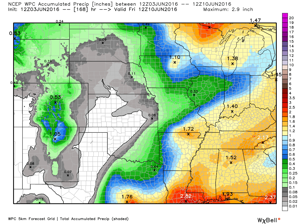
How much precipitation should we expect over the next few days?

Here are the current river stage forecasts. You can click your state and then the dot for your location. It will bring up the full forecast and hydrograph.
..

Here is the official 6-10 day and 8-14 day temperature and precipitation outlook. Check the date stamp at the top of each image (so you understand the time frame).
The forecast maps below are issued by the Weather Prediction Center (NOAA).


The latest 8-14 day temperature and precipitation outlook. Note the dates are at the top of the image. These maps DO NOT tell you how high or low temperatures or precipitation will be. They simply give you the probability as to whether temperatures or precipitation will be above or below normal.


Who do you trust for your weather information and who holds them accountable?
I have studied weather in our region since the late 1970’s. I have 37 years of experience in observing our regions weather patterns. My degree is in Broadcast Meteorology from Mississippi State University and an Associate of Science (AS). I am currently working on my Bachelor’s Degree in Geoscience.
My resume includes:
Member of the American Meteorological Society.
NOAA Weather-Ready Nation Ambassador.
Meteorologist for McCracken County Emergency Management. I served from 2005 through 2015.
I own and operate the Southern Illinois Weather Observatory.
Recipient of the Mark Trail Award, WPSD Six Who Make A Difference Award, Kentucky Colonel, and the Caesar J. Fiamma” Award from the American Red Cross.
In 2009 I was presented with the Kentucky Office of Highway Safety Award.
Recognized by the Kentucky House of Representatives for my service to the State of Kentucky leading up to several winter storms and severe weather outbreaks.
I am also President of the Shadow Angel Foundation which serves portions of western Kentucky and southern Illinois.
There is a lot of noise on the internet. A lot of weather maps are posted without explanation. Over time you should learn who to trust for your weather information.
My forecast philosophy is simple and straight forward.
- Communicate in simple terms
- To be as accurate as possible within a reasonable time frame before an event
- Interact with you on Twitter, Facebook, and the blog
- Minimize the “hype” that you might see on television or through other weather sources
- Push you towards utilizing wall-to-wall LOCAL TV coverage during severe weather events
I am a recipient of the Mark Trail Award, WPSD Six Who Make A Difference Award, Kentucky Colonel, and the Caesar J. Fiamma” Award from the American Red Cross. In 2009 I was presented with the Kentucky Office of Highway Safety Award. I was recognized by the Kentucky House of Representatives for my service to the State of Kentucky leading up to several winter storms and severe weather outbreaks.
If you click on the image below you can read the Kentucky House of Representatives Resolution.

Many of my graphics are from www.weatherbell.com – a great resource for weather data, model data, and more


You can sign up for my AWARE email by clicking here I typically send out AWARE emails before severe weather, winter storms, or other active weather situations. I do not email watches or warnings. The emails are a basic “heads up” concerning incoming weather conditions.