For those of you are not subscribing. I brought on some help for long range forecasts a month or so ago.
This is the kind of information that is available for $3 a month.
You can subscribe at www.beaudodsonweather.com
You have to get to the point where you enter your phone number and other information in order to receive this information.
You can find all of my daily links on the Severe Weather Outlook tab and the Live Feed tab on the WeatherTalk.com website.
Link to graphics and long range video
https://wtalk.co/L9U46HQJ
Wednesday, July 26, 2017
Hot day ahead of us, folks, but relief is on the way.
Heat index values today of 102 to 110 degrees. Actual air temperatures in the 94 to 98 degree range. Use care, as always
We have the potential for severe weather late tonight (far north) and area-wide on Thursday.
I am also concerned about the heavy rain potential. Any slow moving storms will produce two to three inches of rain per hour.
Extremely high PWAT values (moisture of moisture in the entire atmosphere) mean that the atmosphere is filled to the brim with moisture. Hopefully we won’t have training storms. Training storms is when storms repeatedly move over the same areas.
Damaging wind is the main severe weather concern. I can’t rule out hail on Thursday, as well. The main concern, however, will be a few reports of wind damage.
Storms over the last few days have been prolific lightning producers. That will continue until the cold front passes Thursday night.
Much drier and cooler air will start to arrive on Friday and peak on Saturday and Sunday.
High temperatures in the upper 70’s to lower 80’s are anticipated for both Saturday and Sunday. GREAT camping weather this weekend.
Here is the 4 am future-cast radar for Thursday morning. We will have to see how far south the line will hold together late tonight. We could have some strong storms over our far northern counties late tonight, as well.
SPC severe weather outlook for Thursday. A level 2 out of 5 risk for our region.
.


Videos can be viewed at this link. Long Range Video Update
If you believe you missed a video then you can also click the LIVE FEED link on the Weather Talk website. That page holds links for several days.
I can text you the videos, as well. Make sure you have text option FOUR turned on. That would be the Weather Extra text option. Sign up for the text messages at www.beaudodsonweather.com
.
 .
..
This forecast update covers southern Illinois, southeast Missouri, western Kentucky. and northwest Tennessee.
.
The following link is for Weather Text subscribers. This is the page where short and long range video outlooks have been posted. The videos are being produced by a team of meteorologists. Some of the best in the region.
https://weathertalk.com/app/beaucast
.
July 25, 2017
Tuesday Night Forecast Details:
Forecast: Partly cloudy. Warm. Evening heavy thunderstorms possible. Storms will produce heavy rain, gusty winds, and prolific lightning. Isolated risk for damaging winds. A few storms possible overnight, as well.
Temperatures: MO ~ 70 to 75 IL ~ 70 to 75 KY ~ 70 to 75 TN ~ 70 to 75
Winds: East and southeast winds at 4 to 8 mph.
What impacts are anticipated from the weather? Isolated wet roadways and lighting.
My confidence in the forecast verifying: High. This forecast should verify
Is severe weather expected? Small risk for damaging winds
The NWS defines severe weather as 58 mph winds or great, 1″ hail or larger, and/or tornadoes
What is the chance of precipitation? MO ~ 30% IL ~ 30% KY ~ 40% TN ~ 40%
Coverage of precipitation: Scattered early and then isolated late.
Should I cancel my outdoor plans? No, but check radars
.
July 26, 2017
Wednesday Forecast Details
Forecast: Mostly to partly sunny. Isolated to scattered thunderstorms possible. Hot. Muggy. Heat index values of 100 to 108 degrees. Locally higher numbers possible.
Temperatures: MO ~ 94 to 96 IL ~ 94 to 96 KY ~ 94 to 96 TN ~ 94 to 96
Winds: South and southeast winds at 6 to 12 mph with gusts to 16 mph
What impacts are anticipated from the weather? Isolated wet roadways and lighting.
My confidence in the forecast verifying: High. This forecast should verify.
Is severe weather expected? Unlikely, but monitor updates
The NWS defines severe weather as 58 mph winds or great, 1″ hail or larger, and/or tornadoes
What is the chance of precipitation? MO ~ 30% IL ~ 30% KY ~ 30% TN ~ 30%
Coverage of precipitation: Isolated to scattered
Should I cancel my outdoor plans? No, but check radars.
.
Wednesday Night Forecast Details:
Forecast: Partly cloudy. Warm. An increasing chances for thunderstorms moving in from the northwest and north. Some storms could produce heavy rain, frequent lightning, and gusty winds. Greater risk over the northern half of southeast Missouri and northern half of southern Illinois. The line would then move southward, but may weaken as it moves further and further south.
Temperatures: MO ~ 72 to 76 IL ~ 72 to 76 KY ~ 74 to 78 TN ~ 74 to 78
Winds: South and southwest at 8 to 16 mph and gusty.
What impacts are anticipated from the weather? Wet roadways. Lightning, Gusty winds near storms. Heavy downpours possible. Dime size hail possible.
My confidence in the forecast verifying: High. This forecast should verify.
Is severe weather expected? I can’t rule out damaging winds over the northern parts of southeast Missouri and northern parts of southern Illinois. Monitor updates.
The NWS defines severe weather as 58 mph winds or great, 1″ hail or larger, and/or tornadoes
What is the chance of precipitation? MO ~ 50% IL ~ 50% KY ~ 30% TN ~ 30%
Coverage of precipitation: Scattered to perhaps numerous, especially late across the northern half of the region. Lesser chances the further and further south you travel.
Should I cancel my outdoor plans? No, but monitor radars.
.
July 27, 2017
Thursday Forecast Details
Forecast: Quite a few clouds. Showers and thunderstorms likely. Some storms could be intense. There is a chance, if clouds linger, that thunderstorms won’t form or won’t be as heavy as anticipated. Keep this in mind. Clouds could knock down our chances for severe weather or heavy rain. Not unusual. If storms do form, they will be heavy. Very high PWAT values forecasted for Thursday and Thursday night.
Temperatures: MO ~ 85 to 90 IL ~ 85 to 90 KY ~ 85 to 90 TN ~ 85 to 90
Winds: South and southwest winds at 7 to 14 mph with gusts to 22 mph
What impacts are anticipated from the weather? Lightning and wet roadways. Storms could produce locally heavy rain and gusty winds. Low end flash flood risk. A few reports of damaging winds possible.
My confidence in the forecast verifying: Medium. Some adjustments are possible.
Is severe weather expected? Monitor updates. Some storms could be intense with high winds.
The NWS defines severe weather as 58 mph winds or great, 1″ hail or larger, and/or tornadoes
What is the chance of precipitation? MO ~ 60% IL ~ 60% KY ~ 60% TN ~ 60%
Coverage of precipitation: Scattered to numerous.
Should I cancel my outdoor plans? Have a plan B. Rain is possible.
.
Thursday Night Forecast Details:
Forecast: Mostly cloudy. Showers and locally heavy thunderstorms likely. There is a chance, if clouds linger on Thursday, that thunderstorms won’t form or won’t be as heavy as anticipated. Keep this in mind. Clouds could knock down our chances for severe weather or heavy rain. Not unusual. If storms do form, they will be heavy.
Temperatures: MO ~ 68 to 74 IL ~ 68 to 74 KY ~ 68 to 74 TN ~ 68 to 74
Winds: South and southwest winds at 6 to 12 mph with gusts to 18 mph. Winds becoming variable in direction.
What impacts are anticipated from the weather? Lightning and wet roadways. Storms could produce locally heavy rain and gusty winds. Low end flash flood risk. A few reports of damaging winds possible.
My confidence in the forecast verifying: Medium. Some adjustments are possible.
Is severe weather expected? Monitor updates. Some storms could be intense.
The NWS defines severe weather as 58 mph winds or great, 1″ hail or larger, and/or tornadoes
What is the chance of precipitation? MO ~ 60% IL ~ 60% KY ~ 60% TN ~ 60%
Coverage of precipitation: Scattered to numerous
Should I cancel my outdoor plans? Monitor updates. Some storms are likely.
.
July 28, 2017
Friday Forecast Details
Forecast: Partly cloudy. Most likely dry. Not as muggy. A few remaining storms possible over our southern counties near the Missouri/Arkansas line and the Kentucky/Tennessee line. I believe precipitation will be winding down on Friday morning.
Temperatures: MO ~ 82 to 86 IL ~ 82 to 86 KY ~ 82 to 86 TN ~ 82 to 86
Winds: Winds becoming north and northeast at 7 to 14 mph with gusts to 20 mph.
What impacts are anticipated from the weather? If the front moves far enough south, then no impacts. Lightning and wet roadways. Storms could produce locally heavy rain and gusty winds. Lower confidence on Friday’s forecast.
My confidence in the forecast verifying: Medium. Some adjustments are possible.
Is severe weather expected? No
The NWS defines severe weather as 58 mph winds or great, 1″ hail or larger, and/or tornadoes
What is the chance of precipitation? MO ~ 30% IL ~ 20% KY ~ 30% TN ~ 40%
Coverage of precipitation: Precipitation coming to an end.
Should I cancel my outdoor plans? No.
.
Friday Night Forecast Details:
Forecast: Partly cloudy. Turning cooler and less humid.
Temperatures: MO ~ 60 to 65 IL ~ 60 to 65 KY ~ 60 to 65 TN ~ 60 to 65
Winds: North and northeast winds at 5 to 10 mph with gusts to 25 mph
What impacts are anticipated from the weather? Storms should be ending.
My confidence in the forecast verifying: Low. Significant adjustments possible.
Is severe weather expected? No
The NWS defines severe weather as 58 mph winds or great, 1″ hail or larger, and/or tornadoes
What is the chance of precipitation? MO ~ 0% IL ~ 0% KY ~ 0% TN ~ 0%
Coverage of precipitation: Precipitation should have come to an end.
Should I cancel my outdoor plans? No.
.
July 29, 2017
Saturday Forecast Details
Forecast: Partly cloudy. Cooler. Less muggy.
Temperatures: MO ~ 75 to 80 IL ~ 75 to 80 KY ~ 75 to 80 TN ~ 75 to 80
Winds: North and northeast winds at 6 to 12 mph with gusts to 18 mph.
What impacts are anticipated from the weather? None
My confidence in the forecast verifying: Medium. Some adjustments are possible.
Is severe weather expected? No
The NWS defines severe weather as 58 mph winds or great, 1″ hail or larger, and/or tornadoes
What is the chance of precipitation? MO ~ 0% IL ~ 0% KY ~ 0% TN ~ 0%
Coverage of precipitation: None
Should I cancel my outdoor plans? No
.
Saturday Night Forecast Details:
Forecast: Mostly clear. Less humid. Cooler.
Temperatures: MO ~ 62 to 66 IL ~ 62 to 66 KY ~ 62 to 66 TN ~ 62 to 66
Winds: North and northeast winds at 5 to 10 mph with gusts to 15 mph
What impacts are anticipated from the weather? None
My confidence in the forecast verifying: Medium. Some adjustments are possible.
Is severe weather expected? No
The NWS defines severe weather as 58 mph winds or great, 1″ hail or larger, and/or tornadoes
What is the chance of precipitation? MO ~ 0% IL ~ 0% KY ~ 0% TN ~ 0%
Coverage of precipitation: None
Should I cancel my outdoor plans? No.
.
July 30, 2017
Sunday Forecast Details
Forecast: Mostly sunny. Nice. Not as humid.
Temperatures: MO ~ 76 to 82 IL ~ 76 to 82 KY ~ 76 to 82 TN ~ 76 to 82
Winds: North and northeast winds at 6 to 12 mph.
What impacts are anticipated from the weather? None
My confidence in the forecast verifying: Medium. Some adjustments are possible
Is severe weather expected? No
The NWS defines severe weather as 58 mph winds or great, 1″ hail or larger, and/or tornadoes
What is the chance of precipitation? MO ~ 0% IL ~ 0% KY ~ 0% TN ~ 0%
Coverage of precipitation: None
Should I cancel my outdoor plans? No
.
Sunday Night Forecast Details:
Forecast: Mostly clear.
Temperatures: MO ~ 60 to 65 IL ~ 60 to 65 KY ~ 60 to 65 TN ~ 60 to 65
Winds: North winds at 5 to 10 mph with gusts to 15 mph
What impacts are anticipated from the weather? None
My confidence in the forecast verifying: Medium. Some adjustments are possible
Is severe weather expected? No
The NWS defines severe weather as 58 mph winds or great, 1″ hail or larger, and/or tornadoes
What is the chance of precipitation? MO ~ 0% IL ~ 0% KY ~ 0% TN ~ 0%
Coverage of precipitation: None
Should I cancel my outdoor plans? No.
.
July 31, 2017
Monday Forecast Details
Forecast: Partly cloudy.
Temperatures: MO ~ 80 to 84 IL ~ 80 to 84 KY ~ 80 to 84 TN ~ 80 to 84
Winds: North and northeast winds at 6 to 12 mph.
What impacts are anticipated from the weather? None
My confidence in the forecast verifying: Low. Significant adjustments are possible
Is severe weather expected? No
The NWS defines severe weather as 58 mph winds or great, 1″ hail or larger, and/or tornadoes
What is the chance of precipitation? MO ~ 10% IL ~ 10% KY ~ 10% TN ~ 10%
Coverage of precipitation: Most likely none.
Should I cancel my outdoor plans? No
.
Monday Night Forecast Details:
Forecast: Partly cloudy.
Temperatures: MO ~ 60 to 65 IL ~ 60 to 65 KY ~ 60 to 65 TN ~ 60 to 65
Winds: North winds at 5 to 10 mph with gusts to 15 mph
What impacts are anticipated from the weather? None
My confidence in the forecast verifying: Low. Significant adjustments are possible
Is severe weather expected? No
The NWS defines severe weather as 58 mph winds or great, 1″ hail or larger, and/or tornadoes
What is the chance of precipitation? MO ~ 10% IL ~ 10% KY ~ 10% TN ~ 10%
Coverage of precipitation: Most likely none.
Should I cancel my outdoor plans? No.
.
August 1, 2017
Tuesday Forecast Details
Forecast: Partly cloudy. Warmer. A slight chance for thunderstorms.
Temperatures: MO ~ 85 to 90 IL ~ 85 to 90 KY ~ 85 to 90 TN ~ 85 to 90
Winds: Northeast winds at 6 to 12 mph.
What impacts are anticipated from the weather? None
My confidence in the forecast verifying: Low. Significant adjustments are possible
Is severe weather expected? No
The NWS defines severe weather as 58 mph winds or great, 1″ hail or larger, and/or tornadoes
What is the chance of precipitation? MO ~ 10% IL ~ 10% KY ~ 10% TN ~ 10%
Coverage of precipitation: Most likely none.
Should I cancel my outdoor plans? No
.
Tuesday Night Forecast Details:
Forecast: Partly cloudy.
Temperatures: MO ~ 64 to 68 IL ~ 64 to 68 KY ~ 64 to 68 TN ~ 64 to 68
Winds: East winds at 5 to 10 mph
What impacts are anticipated from the weather? None
My confidence in the forecast verifying: Low. Significant adjustments are possible
Is severe weather expected? No
The NWS defines severe weather as 58 mph winds or great, 1″ hail or larger, and/or tornadoes
What is the chance of precipitation? MO ~ 10% IL ~ 10% KY ~ 10% TN ~ 10%
Coverage of precipitation: Most likely none.
Should I cancel my outdoor plans? No.
.

Don’t forget to check out the Southern Illinois Weather Observatory web-site for weather maps, tower cams, scanner feeds, radars, and much more! Click here

A severe thunderstorm is defined as a storm that produces quarter size hail or larger, 58 mph winds or greater, and/or a tornado. That is the official National Weather Service definition of a severe thunderstorm.
Tuesday night through Wednesday night: Isolated summer pop-up storms are possible into Wednesday. Some of the storms will produce heavy rain, frequent lightning, and gusty winds.
There is a chance greater coverage on Wednesday night, especially late. A cold front will slowly push into the region from the north. A few storms could be strong. The best chance for stronger storms will be over northern parts of southeast Missouri and northern parts of southern Illinois. Monitor updates.
Thursday through Thursday night: Thunderstorms are likely on Thursday and Thursday night. They may linger into Friday, but data has been trending drier for Friday. Some of the storms could become severe. Torrential rain is possible with an extremely moist atmosphere. Storms will also produce frequent lightning and strong winds. Monitor updates concerning the potential for severe weather and heavy rain.
Saturday through Wednesday: Severe weather is not anticipated.

BIG weather changes are on the way. I think most people are going to appreciate the incoming cold front. Collective cheers are appropriate.
The front arrives on Thursday and Thursday night. Cooler and drier air will arrive behind the front. The air-mass will feel much nicer than recent weeks. Lower temperatures, lower humidity, and lower dew points. That all spells great camping weather this weekend!
Let’s break it down
Tuesday night into Wednesday
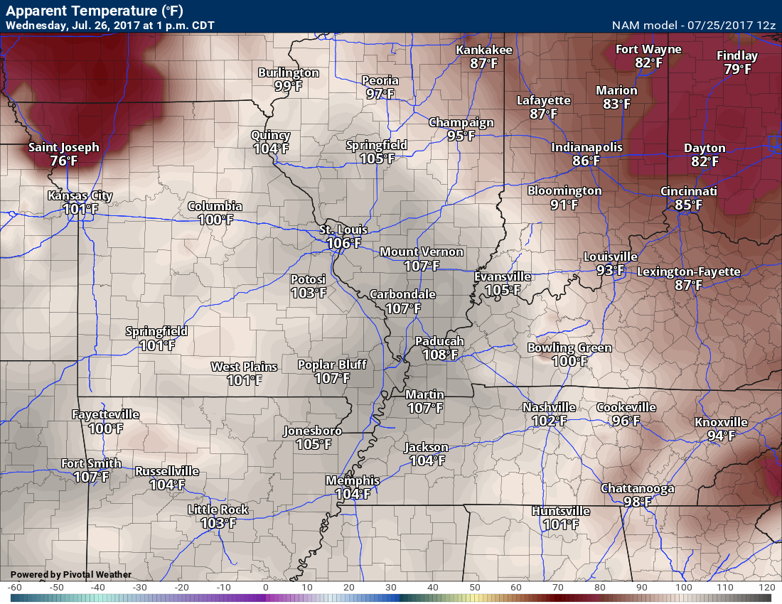
More of the same. Warm/hot and muggy. Overnight lows in the 70’s and daytime highs in the 90’s. Heat index values on Wednesday will climb into the lower 100’s. Ick weather. At least that is what I call it!
Heat index forecast map for Wednesday
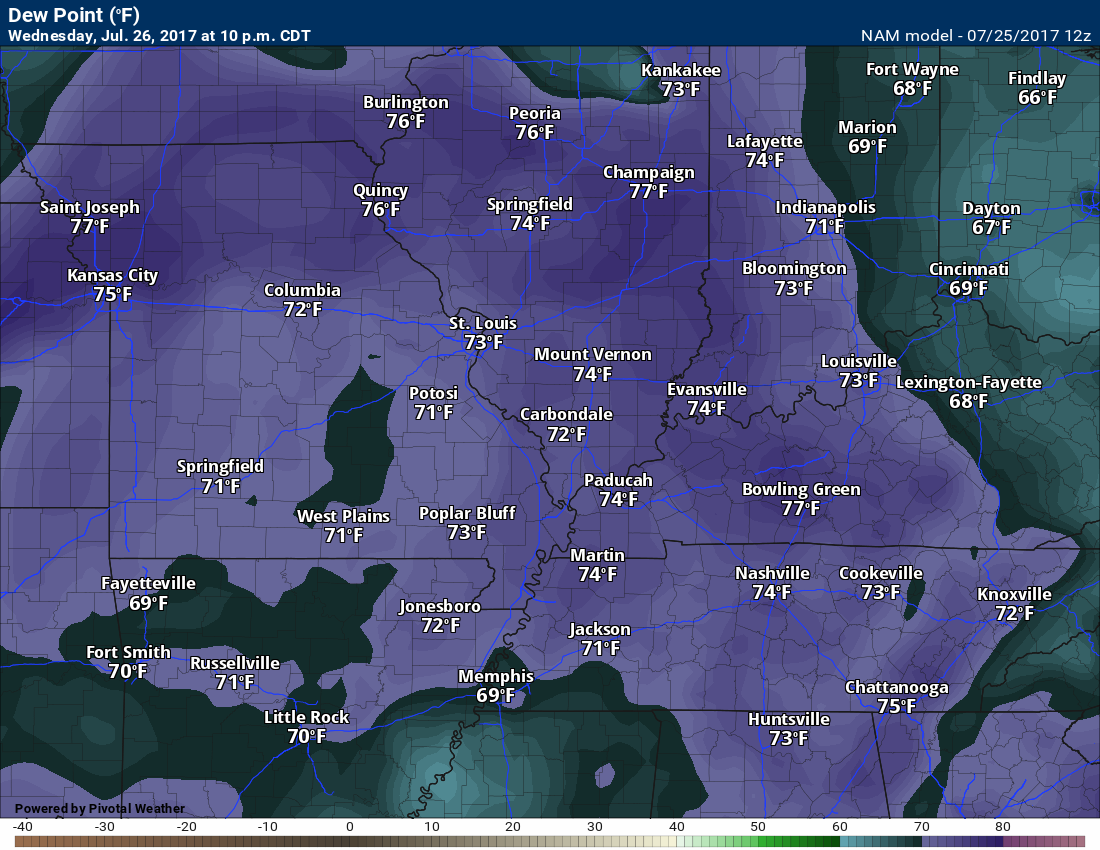
Dew point map for Wednesday. High dew points = muggy conditions.
Isolated storms could pop up both Tuesday night and Wednesday. Where storms occur there will be gully washers and frequent lightning. The bulk of the area will remain dry through Wednesday afternoon. A few spots will pick up an inch or more of rain. Typical summer storms.
Storms on Monday night produced one to two inches of rain in southeast Missouri. Many areas remained dry, but a few areas were drenched.
Wednesday night
Late Wednesday night a cold front will edge into our region from the north. The air ahead of the front will be quite unstable. It will also contain a lot of moisture.
Here are the CAPE numbers for Wednesday night. CAPE is a measure of instability.
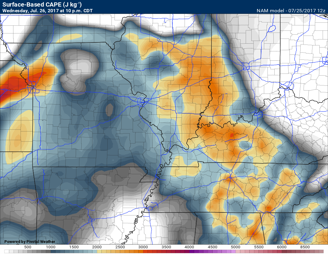
What is CAPE ~ to learn more click here
PWAT values ahead of of the front on Wednesday night. Lot of moisture to work with. PWAT is a measure of moisture in the entire atmosphere. These are big numbers.
This is a PWAT map from the College of Dupage. Those pink colors are top of the chart. PWAT values of 2.8″ or higher. Incredible moisture in the atmosphere.
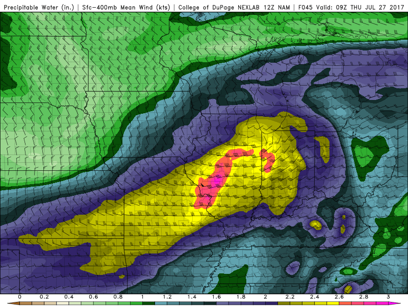
Learn more about PWAT values ~ click here
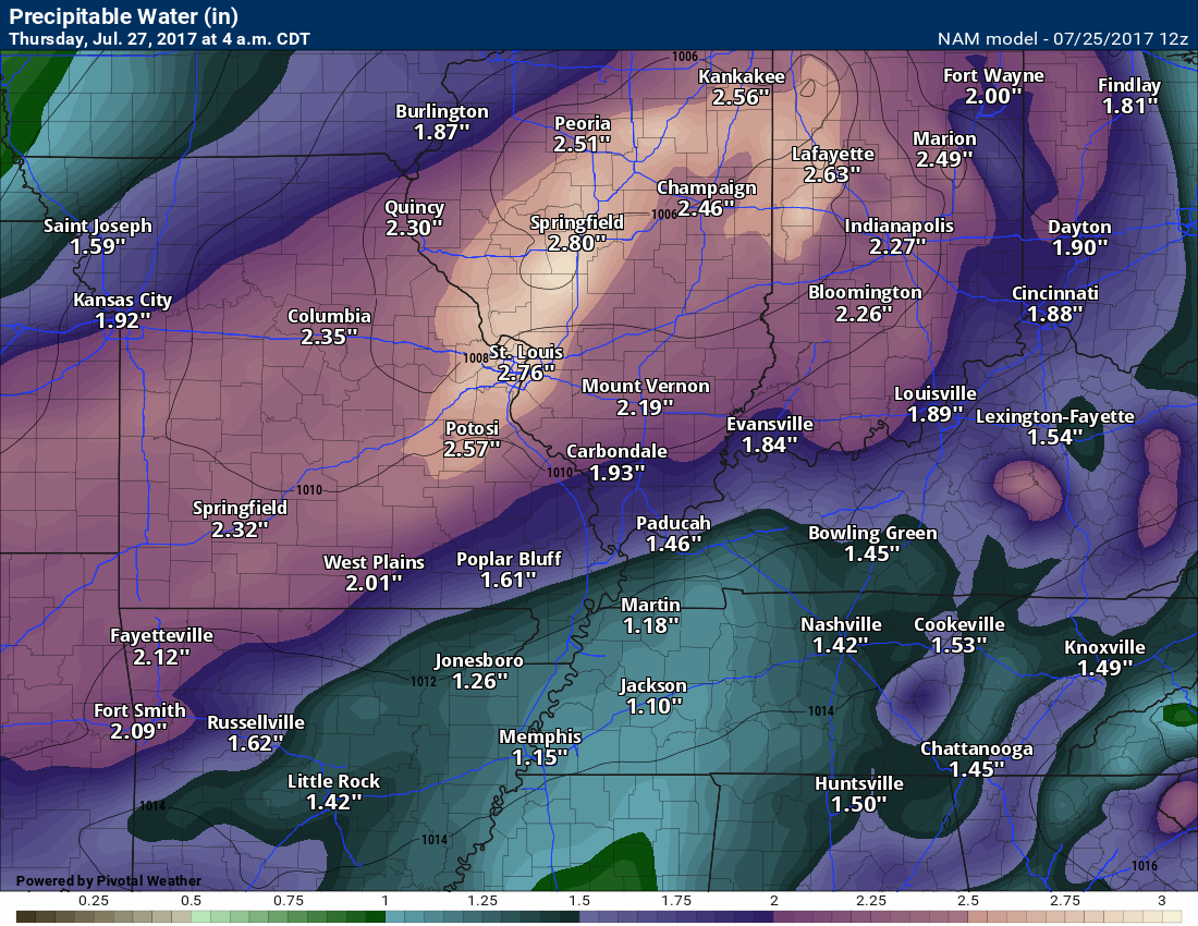
Here is the Thursday 4 am PWAT map.
I suspect storms will enter our northern counties late Wednesday night/Thursday morning. The storms would most likely occur north of a line from Perry County, Missouri, eastward towards Carbondale/Marion, Illinois, and then towards Evansville. From there northward is where the best chance of storms will occur.
Storms that form could be intense with high winds, heavy rain, and frequent lightning. Pea to dime size hail, as well.
Future-cast radar. Remember, this is one models opinion and these are rarely spot on. Use this for guidance and not gospel.
Wednesday 10 PM
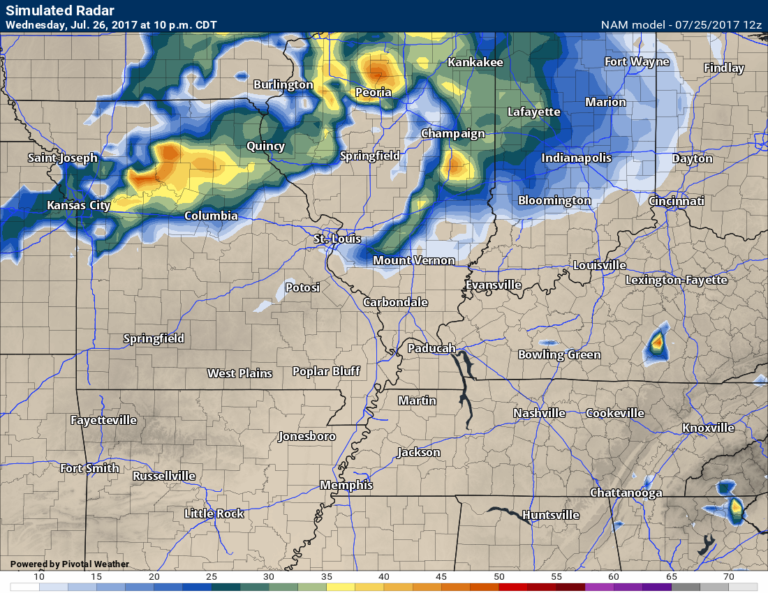
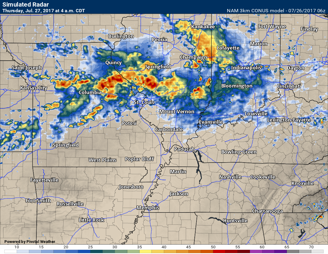
Radar at 4 am on Thursday morning
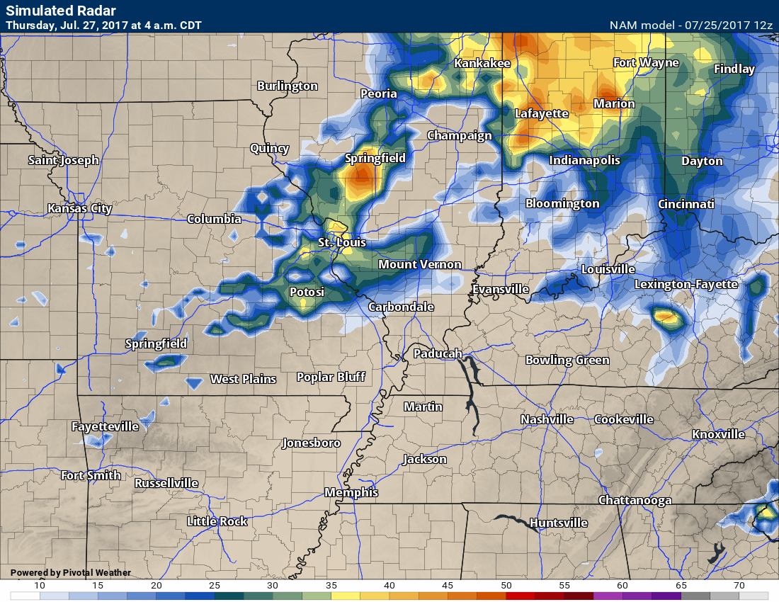
The line of storms will slide southward into Thursday morning. There remain some questions as to how much they will weaken as they move further and further south towards the Ohio River.
Thursday and Thursday night
The cold front moves into our area. Showers and thunderstorms will be possible along the front. Some of the storms could produce high winds, heavy rain, frequent lightning, and small hail. I can’t rule out severe weather.
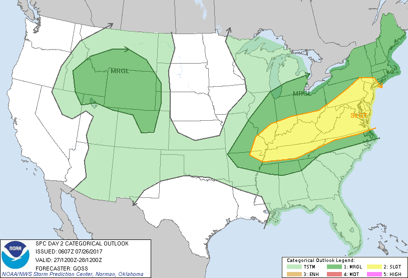
The Storm Prediction Center has placed us in a level 1 risk for Thursday. That is a marginal risk. A marginal risk means that a few storms could become severe. Widespread severe weather is unlikely.
Here is the SPC outlook. Dark green (level 1 out of 5 risk) is the marginal risk. Yellow is a level 2 out of 5 risk (a slight risk).
The light green represents general non-severe thunderstorms.
Wednesday outlook (monitor late Wednesday night over our northern counties)
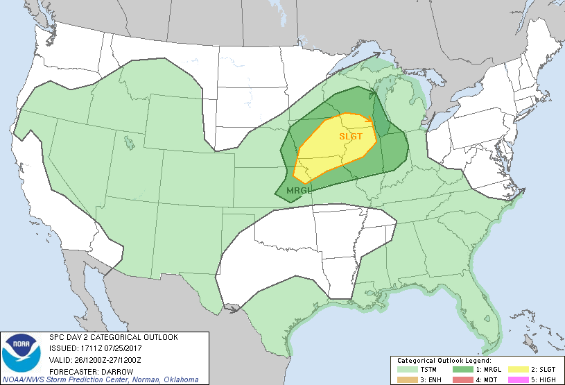
Thursday severe weather outlook
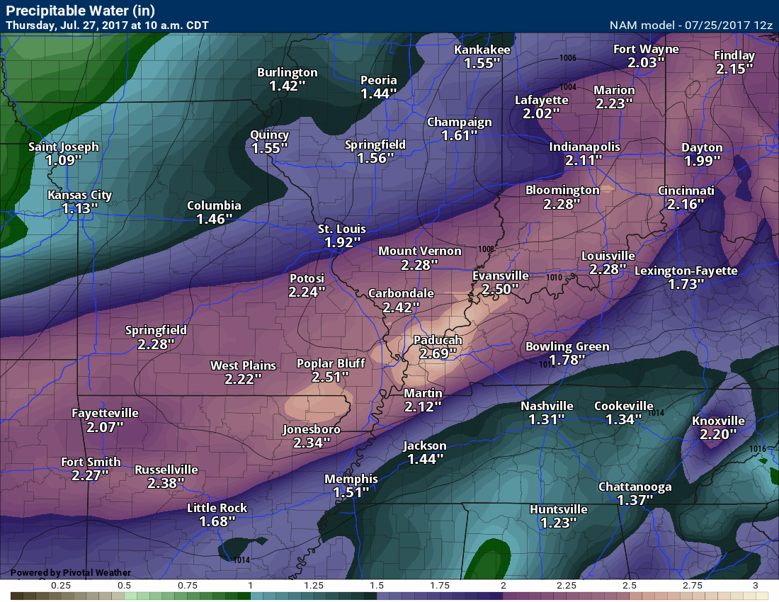
The atmosphere on Thursday will be primed for heavy rain. Any storms that train over the same areas could cause a brief period of flash flooding. Rainfall rates of 1.5 to 3″ per hour will be possible. That means if a couple of storms track over the same area they will pick up a considerable amount of rain.
Generally, this system should produce 0.40″ to 0.80″ of rain for the area. Then, there will be pockets of one to three inches. This is not uncommon during the summer months. Many of you already know this.
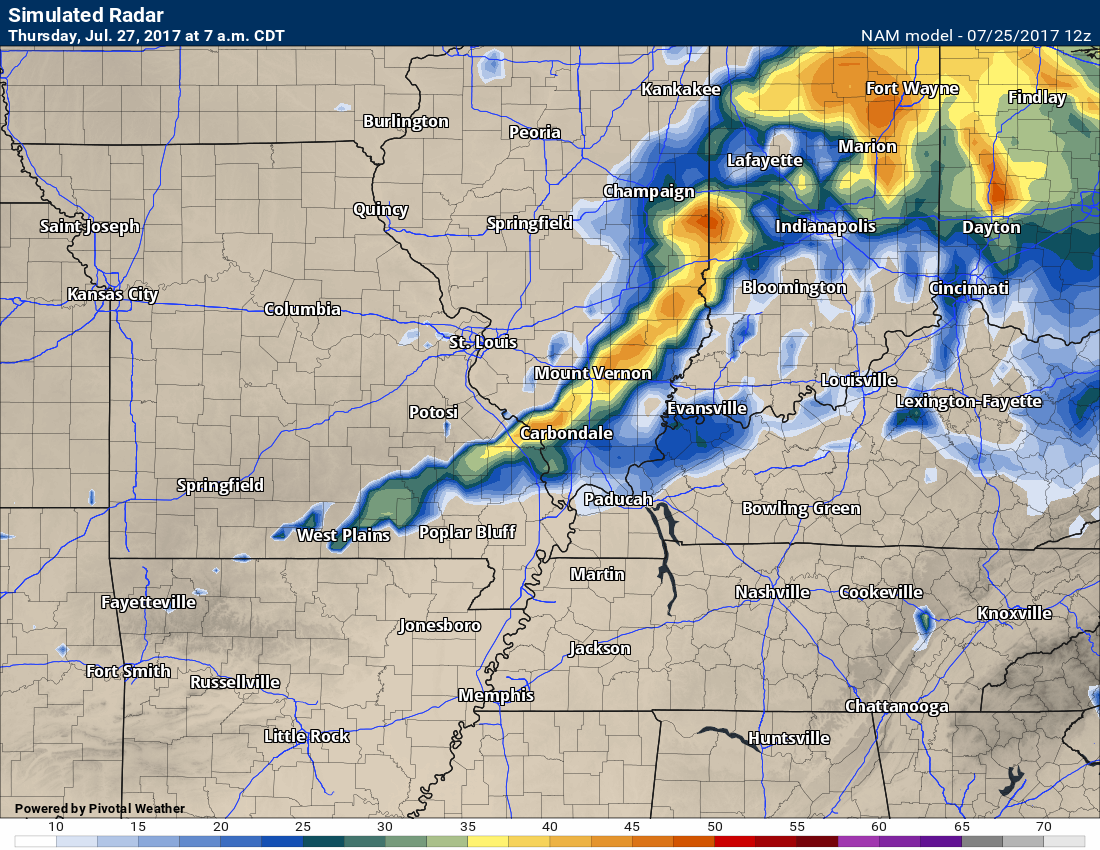
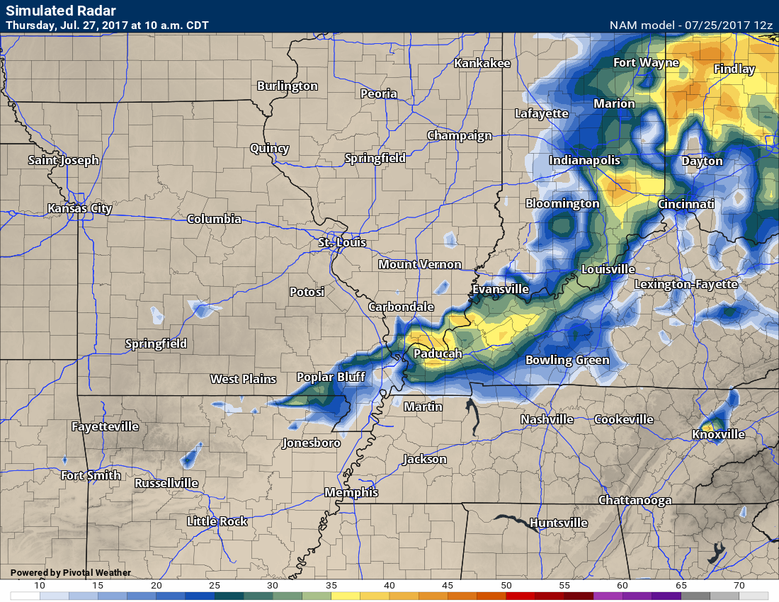
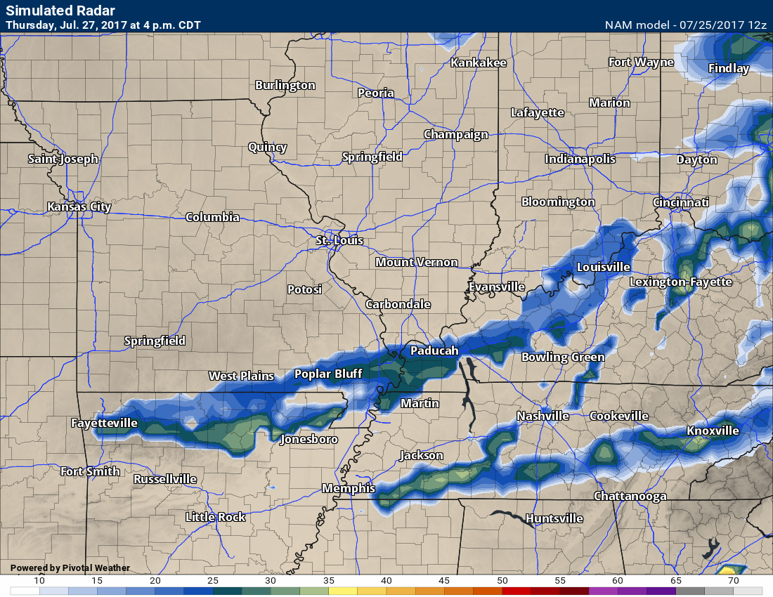
Future-cast radar. Remember, this is one models opinion and these are rarely spot on. Use this for guidance and not gospel.
Thursday 7 am
A line of storms moving through our region according to the NAM model guidance
Thursday at 10 am
Thursday at 4 pm
PWAT values on Wednesday night, Thursday, and Thursday night will be very high. Numbers north of 2.4″ are possible. That means the atmosphere is loaded with moisture.
Thursday morning at 10 am
Friday into Sunday night
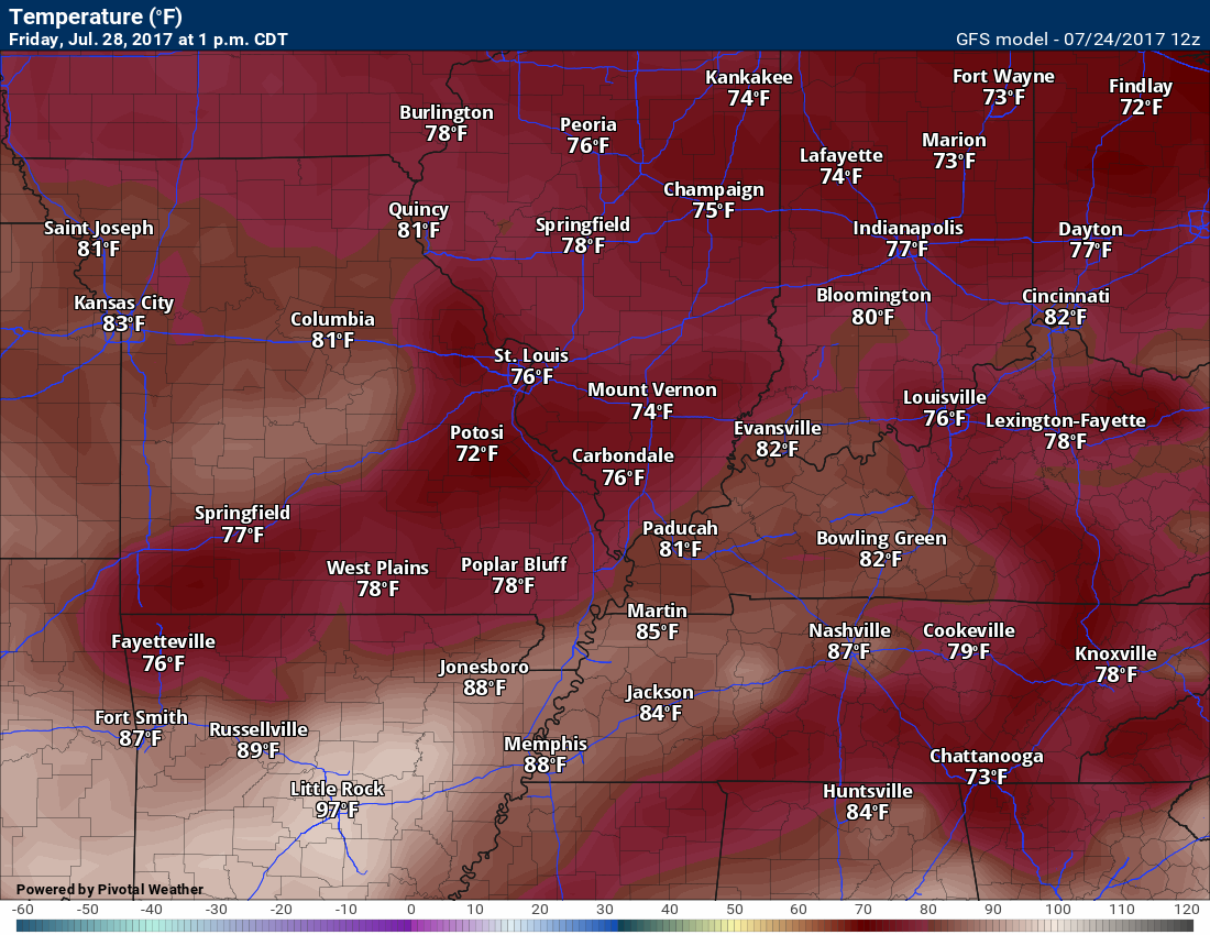
Nice camping weather. There might be a few remaining storms on Friday morning, but I believe most of the activity would have ended. Keep this in mind, however, in case a few storms do linger longer than anticipated.
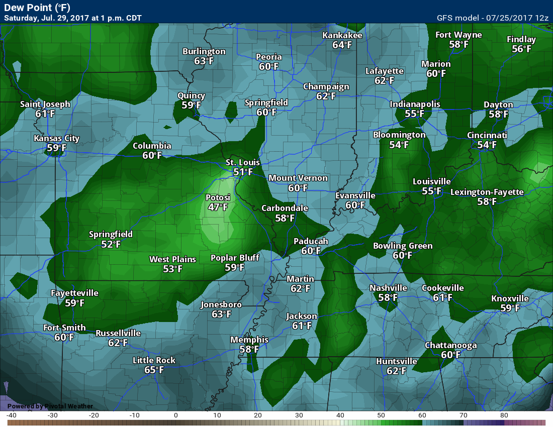
The air mass will be nicer on Friday. Lower dew points. The same for Saturday and Sunday. You are going to feel the difference. There is no doubt about that.
Friday dew point map
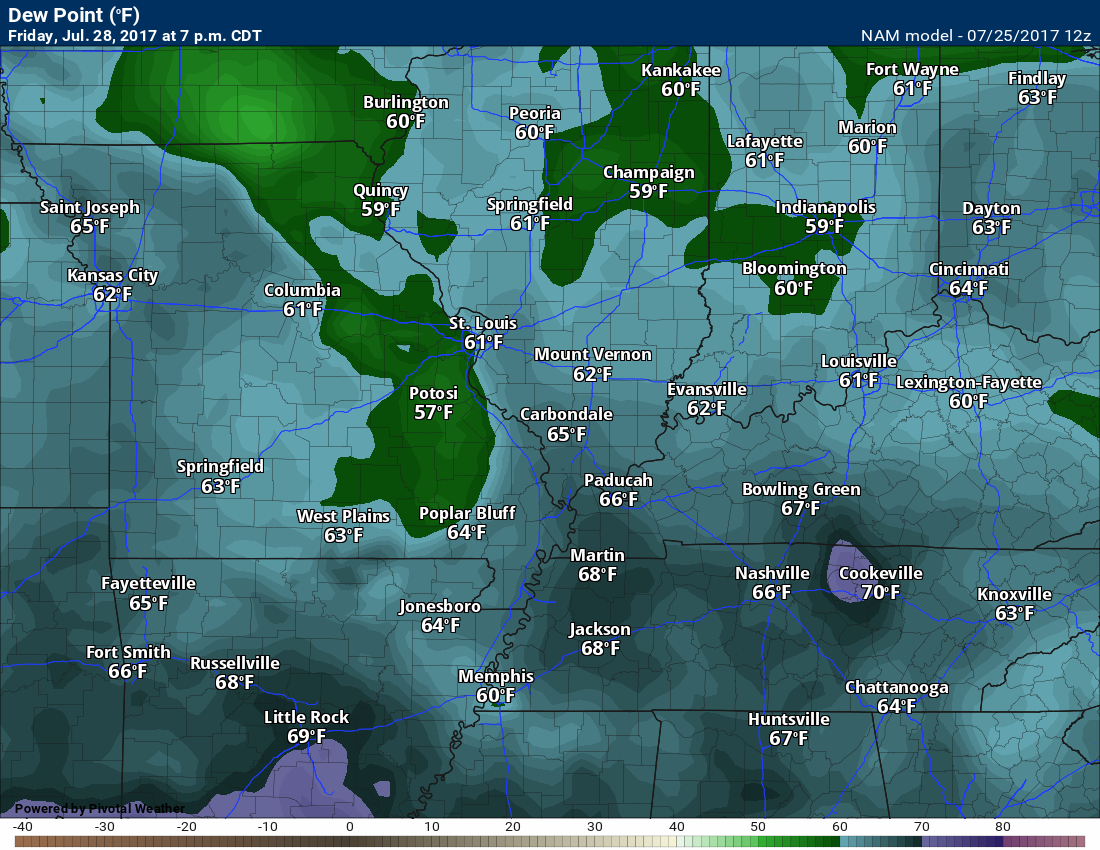
Saturday dew point map
Sunday dew point map
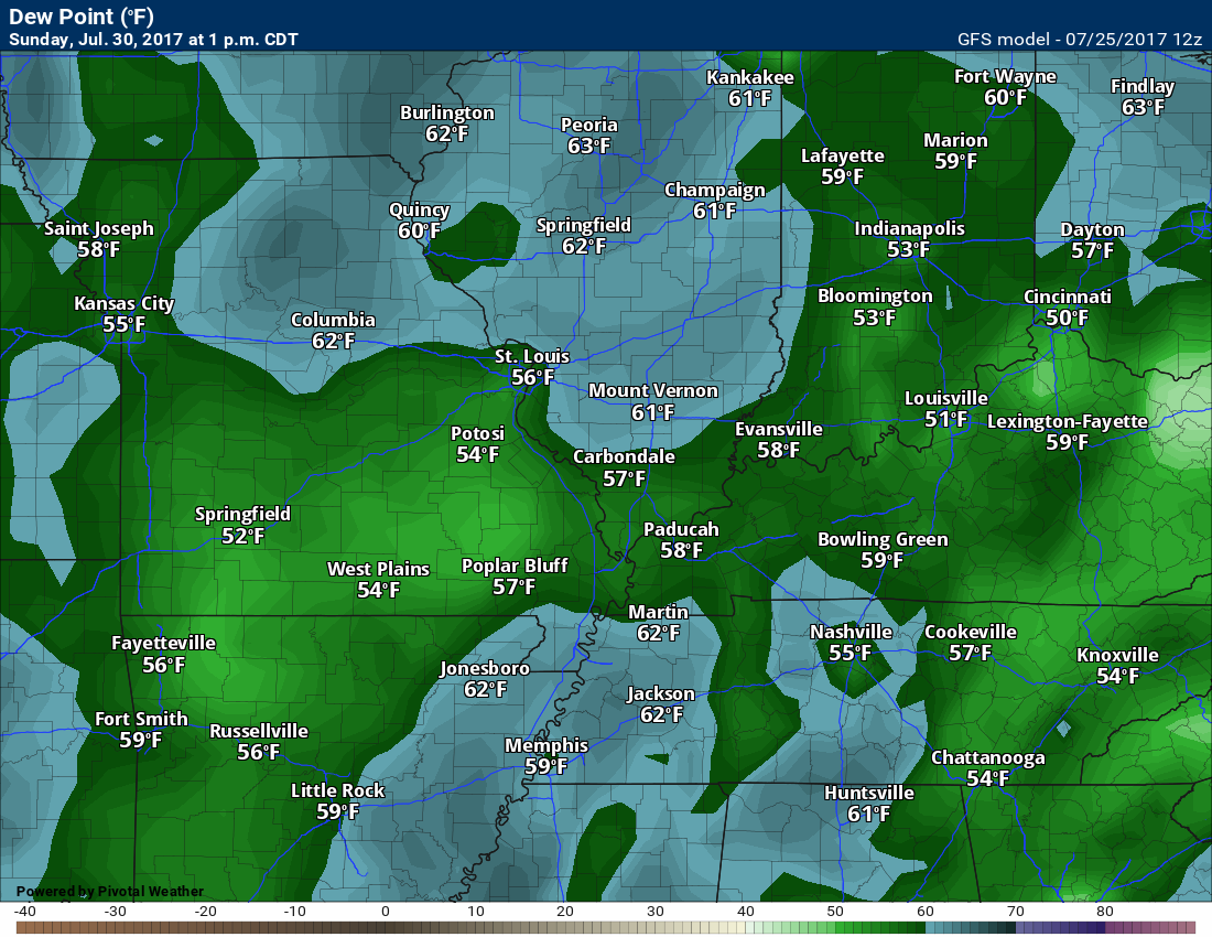
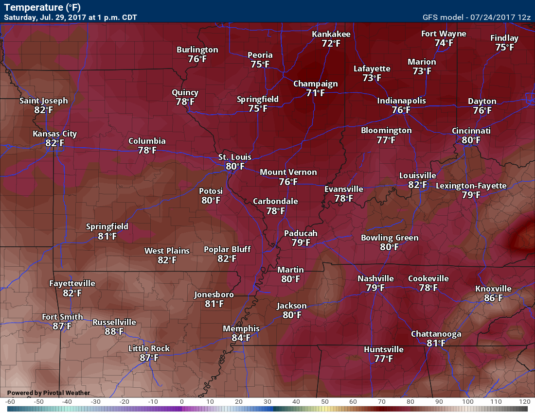
Temperatures will also be lower, as well. Some of the guidance paints upper 70’s for Saturday and Sunday. I went upper 70’s to lower 80’s. It might feel a little cool on Saturday night. Lower dew points combined with temperatures in the sixties will feel quite refreshing. You will be able to open your windows and let some fresh air in.
Friday high temperature map
Saturday high temperatures per the GFS model
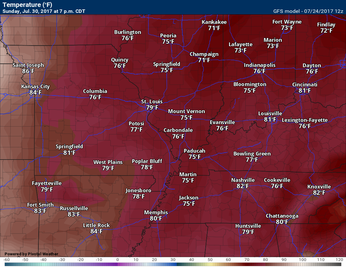
Sunday high temperatures per the GFS model
Next week should deliver mostly below normal temperatures. Some of the models want to build the heat ridge back into the region by the end of the week.
The GFS has us flirting with 90’s on Wednesday. This will need to be monitored. I went a bit lower than guidance for Tuesday’s highs, but will monitor trends.
As far as precipitation goes, it will likely remain dry on Monday and Tuesday. I am monitoring some weak disturbances on Wednesday and Thursday. This might provide a chance for a few showers or storms. Low confidence on precipitation next week.
We may have to wait until around August 4th through 7th for better rain chances. Long way off.
Are you subscribing to the Weather Talk texts and videos?
We now have premiere videos for the short and long range forecasts! Make sure you have text option four turned on (green).
Sign up at www.beaudodsonweather.com
We also have an Apple and Android app (scroll down to bottom of the page for more information)

Were you aware that I have hired some help for long range videos? Short range videos, as well. An amazing team of meteorologists.
Click the link below to read more
http://cms.weathertalk.com/meet-the-team/
Weather Talk subscribers now have some of the best short and long range weather videos produced across the eastern United States.
.

Find me on Twitter
.

We have regional radars and local city radars – if a radar does not update then try another one. Occasional browsers need their cache cleared. You may also try restarting your browser. That usually fixes the problem. Occasionally we do have a radar go down. That is why I have duplicates. Thus, if one fails then try another one.
During the winter you can track snow and ice by clicking the winterize button on the local city view interactive radars.
If you have any problems then please send me an email beaudodson@usawx.com
Interactive Weather Radar Page. Choose the city nearest your location: Click this link—
National interactive radar: Click this link.
Local interactive city radars include St Louis, Mt Vernon, Evansville, Poplar Bluff, Cape Girardeau, Marion, Paducah, Hopkinsville, Memphis, Nashville, Dyersburg, and all of eastern Kentucky. These are interactive radars. Local city radars – click here
.

The official 6-10 day and 8-14 day temperature and precipitation outlook. Check the date stamp at the top of each image (so you understand the time frame).
.
The forecast maps below are issued by the Weather Prediction Center (NOAA)
.

.

.
The latest 8-14 day temperature and precipitation outlook. Note the dates are at the top of the image. These maps DO NOT tell you how high or low temperatures or precipitation will be. They simply give you the probability as to whether temperatures or precipitation will be above or below normal.
.


.
The Beau Dodson Weather APP is ready for Apple and Android users. The purpose of this app is for me to deliver your text messages instantly. ATT and Verizon have not always been reliable when it comes to speed. The app allows instant delivery.
Some of you have asked if you can keep receiving the texts on your phone and the app. The answer to that is, yes. The Android app will automatically allow that to happen. On the Apple app, however, you will need to go into your app and click settings. Make sure the green tab is OFF. Off means you will still receive the texts to your phone and the app. If you have any questions, then email me at beaudodson@usawx.com
The app is for text subscribers.
The direct download, for the Apple app, can be viewed here
https://itunes.apple.com/us/app/id1190136514
If you have not signed up for the texting service then you may do so at www.beaudodsonweather.com

The Android app is also ready.
Remember, the app’s are for www.weathertalk.com subscribers. The app allows your to receive the text messages faster than ATT and Verizon.
Here is the download link for the Android version Click Here

——————————————————–
If you have not signed up for the texts messages, then please do. Link www.beaudodsonweather.com
Your support helps with the following:

and


Who do you trust for your weather information and who holds them accountable?
I have studied weather in our region since the late 1970’s. I have 39 years of experience in observing our regions weather patterns. My degree is in Broadcast Meteorology and a Bachelor’s of Science.
My resume includes:
Member of the American Meteorological Society.
NOAA Weather-Ready Nation Ambassador.
Meteorologist for McCracken County Emergency Management. I served from 2005 through 2015.
Meteorologist for McCracken County Rescue. 2015 through current
I own and operate the Southern Illinois Weather Observatory.
I am the chief meteorologist for Weather Talk LLC. I am the owner of Weather Talk LLC.
I am also a business owner in western Kentucky.
Recipient of the Mark Trail Award, WPSD Six Who Make A Difference Award, Kentucky Colonel, and the Caesar J. Fiamma” Award from the American Red Cross.
In 2005 I helped open the largest American Cross shelter in U.S. history in Houston, Texas. I was deployed to help after Hurricane Katrina and Hurricane Rita. I was a shelter manager of one of the Houston, Texas shelter divisions.
In 2009 I was presented with the Kentucky Office of Highway Safety Award.
Recognized by the Kentucky House of Representatives for my service to the State of Kentucky leading up to several winter storms and severe weather outbreaks.
If you click on the image below you can read the Kentucky House of Representatives Resolution.

I am also President of the Shadow Angel Foundation which serves portions of western Kentucky and southern Illinois.
There is a lot of noise on the internet. A lot of weather maps are posted without explanation. Over time you should learn who to trust for your weather information.
My forecast philosophy is simple and straight forward.
- Communicate in simple terms
- To be as accurate as possible within a reasonable time frame before an event
- Interact with you on Twitter, Facebook, email, texts, and this blog
- Minimize the “hype” that you might see on some television stations or through other weather sources
- Push you towards utilizing wall-to-wall LOCAL TV coverage during severe weather events
Many of the graphics on this page are from www.weatherbell.com
WeatherBell is a great resource for weather model guidance.


You can sign up for my AWARE email by clicking here I typically send out AWARE emails before severe weather, winter storms, or other active weather situations. I do not email watches or warnings. The emails are a basic “heads up” concerning incoming weather conditions