![]() .
.

Are you in need of new eye glasses? New contacts? Perhaps you need an eye exam. Then be sure and visit the Eye Care Associates of western Kentucky (the Paducah location). For all of your families eye care needs.
Visit their web-site here. Or, you can also visit their Facebook page.

Best at Enabling Body Shop Profitability since 1996. Located In Paducah Kentucky and Evansville Indiana; serving all customers in between. They provide Customer Service, along with all the tools necessary for body shops to remain educated and competitive. Click the logo above for their main web-site.
You can find McClintock Preferred Finishes on Facebook, as well

Expressway Carwash and Express Lube are a locally owned and operated full-service Carwash and Lube established in 1987.
They have been proudly serving the community for 29 years now at their Park Avenue location and 20 years at their Southside location. They have been lucky enough to partner with Sidecar Deli in 2015, which allows them to provide their customers with not only quality service, but quality food as well.
If you haven’t already, be sure to make Expressway your one-stop shop, with their carwash, lube and deli. For hours of operation and pricing visit www.expresswashlube.com or Expressway Carwash on Facebook.
.
.

Looking for some tasty holiday treats? Fluff Cupcakes has what you and your family need. Located in Benton, Kentucky. They even deliver!
I have used Fluff Cupcakes, during Thanksgiving and Christmas, for the last couple of years. I can tell you that the cupcakes are delicious. Be sure and contact Tracy and place your order. Birthdays, holidays, or just because! Visit them on Facebook at this link – click here

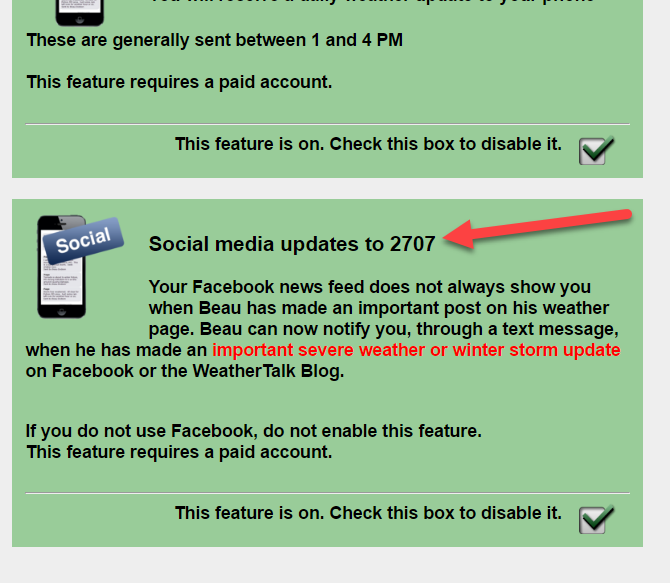
I have launched a new weather texting service! Be sure and sign up and fully support all of the weather data you see each day.
Weather Talk is a monthly subscription texting (and more) service. Supporting this helps cover the daily costs (average monthly costs are $700+) or all of the data, my time, and the Shadow Angel Foundation. The cost is $3 a month for one phone, $5 a month for three phones, and $10 a month for seven phones. You can sign up and opt out of the text messages, as well.
For more information visit BeauDodsonWeather.com
If you would like to receive a text notification, when the winter weather outlooks are updated, then make sure you have opted in to text option three. These are found behind the Personal Notification Settings on the weathertalk.com page.
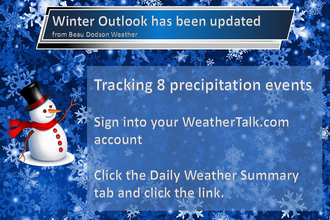
Winter storm forecasts will be posted on the www.weathertalk.com website. Look under the Daily Weather Summary tab.

This forecast update covers far southern Illinois, far southeast Missouri, and far western Kentucky. See the coverage map on the right side of the blog
January 7, 2017
Saturday Night: Mostly clear and bitterly cold.
What impact is expected? Cold wind chills. Frost bite.
My confidence in this part of the forecast verifying: High. This forecast should verify.
Temperatures: Low temperatures from 8 to 14 degrees (coldest where snow blankets the ground). Temperatures will vary considerably from north to south.
Wind Chill: 5 to 10 above
Winds: Light winds less than 6 mph.
What is the chance of precipitation? MO ~ 0% IL ~ 0% KY ~ 0% TN ~ 0%
Coverage of precipitation: None
Will there be a chance for frozen precipitation? No
Is severe weather expected? No
Should I cancel my outdoor plans? No, but it will be cold.
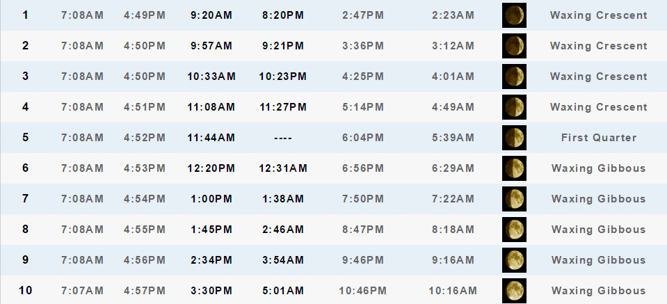
Sunset will be at 4:54 p.m.
Moonrise will be at 1:00 p.m. and moonset will be at 1:38 Waxing Gibbous
.
January 8, 2017
Sunday: Mostly sunny during the morning. Increasing clouds through the day.
What impact is expected? Morning temperatures and wind chills will be bitterly cold.
My confidence in this part of the forecast verifying: Medium. Some adjustments are possible.
Temperatures: High temperatures in the 28 to 34 degree range
Wind Chill: 5 to 10 degrees early in the morning.
Winds: Calm winds becoming variable and eventually east/southeast at 5-10 mph
What is the chance of precipitation? MO ~ 10% IL ~ 10% KY ~ 10% TN ~ 10%
Coverage of precipitation? Most likely none
Will there be a chance for frozen precipitation? Unlikely
Is severe weather expected? No
Should I cancel my outdoor plans? No, but it will be cold.
Sunrise will be at 7:08 a.m. and sunset will be at 4:55 p.m.
UV Index: 1-2
Moonrise will be at 1:45 p.m. and moonset will be at 2:46 a.m. Waxing Gibbous
Sunday Night: Cloudy. Perhaps some clearing after midnight. Cold.
What impact is expected? Most likely none.
My confidence in this part of the forecast verifying: Medium. Some adjustments are possible.
Temperatures: Low temperatures from 16 to 22 degrees.
Wind Chill: 10 to 18 degrees
Winds: South and southeast winds at 6 to 12 mph. Perhaps gusty winds after 2 am.
What is the chance of precipitation? MO ~ 10% IL ~ 10% KY ~ 0% TN ~ 0%
Coverage of precipitation: Most likely none
Will there be a chance for frozen precipitation? Unlikely
Is severe weather expected? No
Should I cancel my outdoor plans? No, but it will be cold.
.
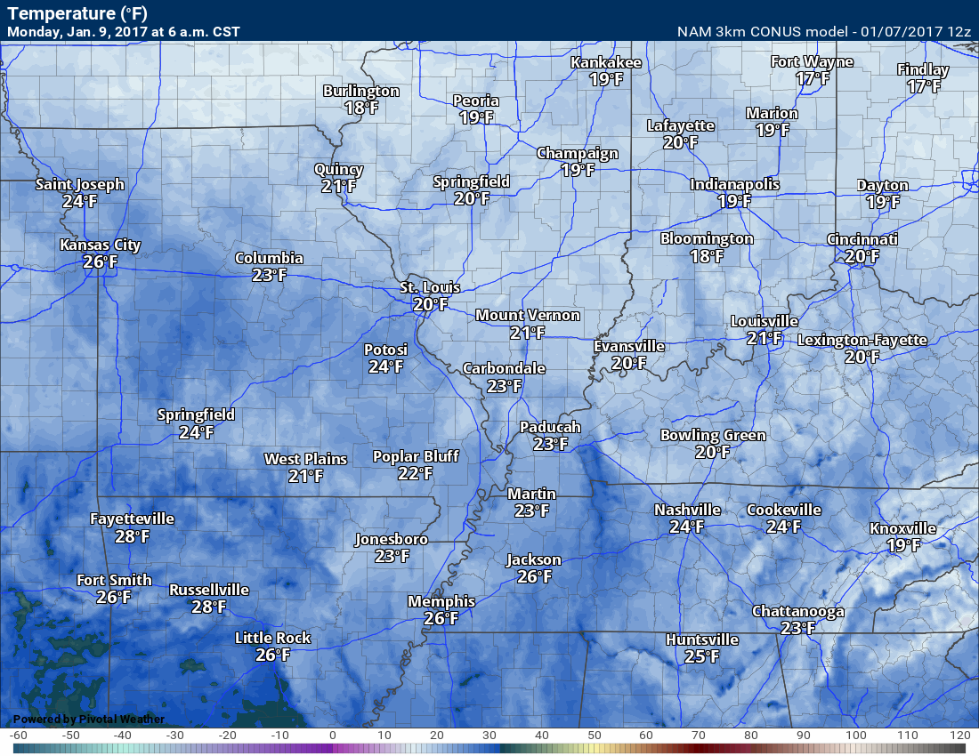
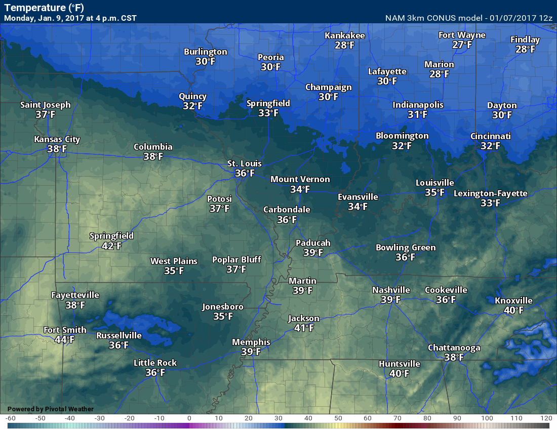
January 9, 2017
Monday: A mix of sun and clouds. Not as cold as recent days.
What impact is expected? Most likely none
My confidence in this part of the forecast verifying: Medium. Some adjustments are possible.
Temperatures: High temperatures in the 36 to 44 degree range
Wind Chill: 15-25 degrees early in the morning.
Winds: South and southeast 6 to 12 mph with gusts to 15 mph
What is the chance of precipitation? MO ~ 0% IL ~ 0% KY ~ 0% TN ~ 0%
Coverage of precipitation? None
Will there be a chance for frozen precipitation? None
Is severe weather expected? No
Should I cancel my outdoor plans? No, but it will be cold.
Sunrise will be at 7:07 a.m. and sunset will be at 4:56 p.m.
UV Index: 1-2
Moonrise will be at 2:34 p.m. and moonset will be at 3:54 a.m. Waxing Gibbous
Monday Night: Cloudy. A 40% for showers. Breezy, at times.
What impact is expected? Wet roadways possible. Gusty winds.
My confidence in this part of the forecast verifying: Medium. Some adjustments are possible.
Temperatures: Low temperatures early in the night (30’s). Temperatures may rise into the 40’s by sunrise
Wind Chill:
Winds: South winds at 10-20 mph with gusts to 35 mph
What is the chance of precipitation? MO ~ 40% IL ~ 40% KY ~ 40% TN ~ 40%
Coverage of precipitation: Increasing coverage through the night
Will there be a chance for frozen precipitation? Not at this time.
Is severe weather expected? No
Should I cancel my outdoor plans? No, but monitor radars and rain coverage.
.
January 10, 2017
Tuesday: Cloudy. Mild. Showers likely. A rumble of thunder possible. Windy.
What impact is expected? Wet roadways. Perhaps lightning. Breezy.
My confidence in this part of the forecast verifying: Medium. Some adjustments are possible.
Temperatures: High temperatures in the 56 to 62 degree range.
Wind Chill:
Winds: South at 10-20 mph with gusts to 38 mph.
What is the chance of precipitation? MO ~ 60% IL ~ 60% KY ~ 60% TN ~ 60%
Coverage of precipitation? Scattered to widespread
Will there be a chance for frozen precipitation? None
Is severe weather expected? Most likely no
Should I cancel my outdoor plans? Have a plan B
Sunrise will be at 7:07 a.m. and sunset will be at 4:57 p.m.
UV Index: 0
Moonrise will be at 3:30 p.m. and moonset will be at 5:01 a.m. Waxing Gibbous
Tuesday Night: Cloudy. Showers possible. Rumble of thunder possible. There could be a wide range of temperatures from north to south.
What impact is expected? Wet roadways. Gusty winds. Maybe lightning.
My confidence in this part of the forecast verifying: Medium. Some adjustments are possible.
Temperatures: Low temperatures from 36 to 42. There could be a large range of temperatures as a front will be in the area.
Wind Chill:
Winds: Southwest to west at 10-25 mph and gusty. Winds becoming west and northwest after frontal passage.
What is the chance of precipitation? MO ~ 60% IL ~ 60% KY ~ 60% TN ~ 60%
Coverage of precipitation: Scattered to perhaps widespread.
Will there be a chance for frozen precipitation? No
Is severe weather expected? Unlikely, but monitor updates.
Should I cancel my outdoor plans? Have a plan B.
.
Complicated forecast Wednesday through next weekend. A frontal boundary in or near the region might mean a wide range of temperatures. I can’t rule out a wintry mix over portions of the region late in the week. The boundary and temperatures will need to be closely monitored.
I will be monitoring for the potential of heavy rain, as well.
Significant adjustments are possible in the overall forecast.
January 11, 2017
Wednesday: Cloudy. Showers possible. Wide range of temperatures possible in the region
What impact is expected? Wet roadways.
My confidence in this part of the forecast verifying: Medium. Some adjustments are possible.
Temperatures: High temperatures in the 50-55 degrees
Winds: South at 10-20 mph
What is the chance of precipitation? MO ~ 40% IL ~ 40% KY ~ 40% TN ~ 40%
Coverage of precipitation? Scattered
Will there be a chance for frozen precipitation? None
Is severe weather expected? No
Should I cancel my outdoor plans? Monitor. Rain is possible.
Sunrise will be at 7:07 a.m. and sunset will be at 4:58 p.m.
UV Index: 0
Moonrise will be at 4:30 p.m. and moonset will be at 6:03 a.m. Waxing Gibbous
Wednesday Night: Cloudy. Showers possible. It is possible that temperatures rise at night. Front near the region.
What impact is expected? Wet roadways.
My confidence in this part of the forecast verifying: Medium. Some adjustments are possible.
Temperatures: Low temperatures from 48-54 degrees
Wind Chill:
Winds: Northwest winds becoming east/southeast at 10-15 mph.
What is the chance of precipitation? MO ~ 40% IL ~ 40% KY ~ 40% TN ~ 40%
Coverage of precipitation: Scattered
Will there be a chance for frozen precipitation? No
Is severe weather expected? Monitor updates.
Should I cancel my outdoor plans? Monitor updates. Rain is possible.
.
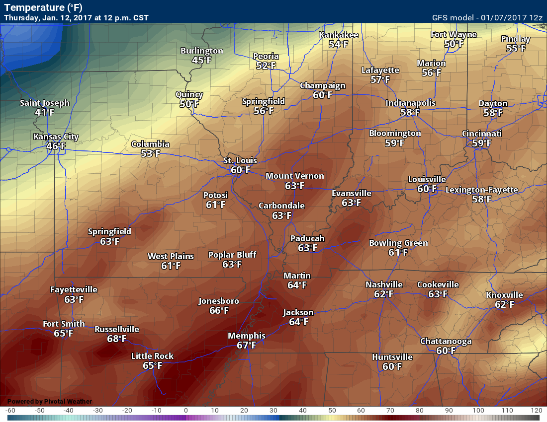
January 12, 2017
Thursday: Cloudy. Warmer. Windy. A chance for showers and thunderstorms.
What impact is expected? Wet roadways. Lightning.
My confidence in this part of the forecast verifying: Low. Significant adjustments are possible.
Temperatures: High temperatures in the 54-58 degree range
Wind Chill:
Winds: South and southwest at 6-12 mph. Winds may vary across the region.
What is the chance of precipitation? MO ~ 40% IL ~ 40% KY ~ 40% TN ~ 40%
Coverage of precipitation? Scattered
Will there be a chance for frozen precipitation? None
Is severe weather expected? Monitor updates
Should I cancel my outdoor plans? Monitor. Rain is possible.
Sunrise will be at 7:07 a.m. and sunset will be at 4:59 p.m.
UV Index: 0 to 1
Moonrise will be at 5:35 p.m. and moonset will be at 7:00 a.m. Waxing Gibbous
Thursday Night: Cloudy. Showers possible. A thunderstorm possible.
What impact is expected? Wet roadways. Lightning.
My confidence in this part of the forecast verifying: Low. Significant adjustments are possible.
Temperatures: Low temperatures from 48-54 degrees. A frontal boundary might mean a wide range of temperatures.
Wind Chill:
Winds: Southwest to west at 8-16 mph
What is the chance of precipitation? MO ~ 40% IL ~ 40% KY ~ 40% TN ~ 40%
Coverage of precipitation: Scattered to perhaps widespread.
Will there be a chance for frozen precipitation? No, but monitor updates
Is severe weather expected? Monitor updates.
Should I cancel my outdoor plans? Monitor updates. Rain is possible.
More information on the UV index. Click here
The School Bus Stop Forecast is sponsored by Heath Health and Wellness. Located next to Crowell Pools in Lone Oak, Kentucky.Visit their website here. And. visit Heath Health Foods on Facebook!

Heath Health Foods is a locally owned and operated retail health and wellness store. Since opening in February 2006; the store has continued to grow as a ministry with an expanding inventory which also offers wellness appointments and services along with educational opportunities.
Visit their web-site here. And. visit Heath Health Foods on Facebook!
.

Don’t forget to check out the Southern Illinois Weather Observatory web-site for weather maps, tower cams, scanner feeds, radars, and much more! Click here

An explanation of what is happening in the atmosphere over the coming day
- Complicated forecast
- Heavy rain potential
- Wintry weather?
- Updated winter weather outlook
Forecast analysis
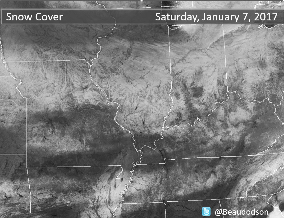
Check out the snow cover in the region.
Can you find the rivers? The white is snow. Isn’t nature amazing. Notice where there is not any snow? Parts of southeast Missouri and western Kentucky have snow. Other parts have nada.
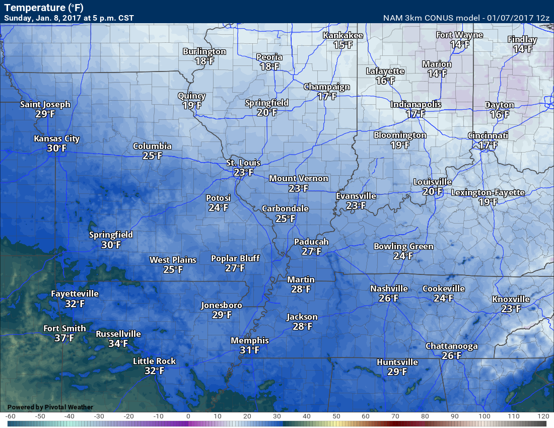
Saturday night through Sunday
Confidence: High
Cold weather will be the main story. Temperatures on Saturday night might dip back into the single digits near Mt Vernon, Illinois. Elsewhere, mostly lower to middle teens. Brrr will once again be the word of the day.
Some increase is clouds is likely on Sunday. Some of the models are showing snow showers on Sunday afternoon. This seems unlikely with dry air at the surface.
Sunday night and Monday
Confidence: Medium
Some clearing on Sunday night before more clouds arrive on Monday.
Shower chances should hold off until Monday evening or night.
Temperatures on Sunday night won’t be as cold as recent nights. Temperatures on Monday won’t be as cold, either.
Expect Sunday night lows to dip into the 20’s and Monday highs to reach into the 30’s and perhaps lower 40’s.
Monday night and Wednesday
Confidence: Medium
Clouds with increasing precipitation chances will be the forecast as we push into Monday night and Tuesday. It appears the precipitation will fall as liquid and not wintry.
I can’t completely rule out a rumble of thunder on Tuesday and Tuesday night.
Gusty winds will arrive on Monday night and continue into Tuesday. Some gusts above 30 mph are likely to occur.
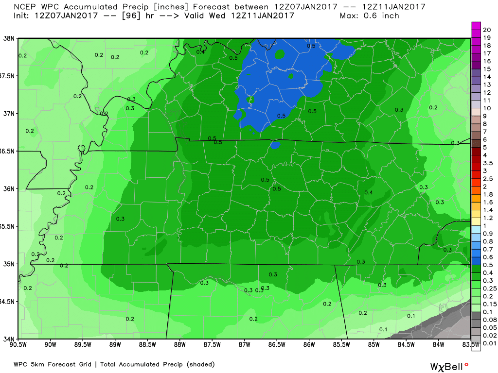
Rainfall totals of 0.20″ to 0.40″ are anticipated Monday night through Wednesday.
Wednesday into Saturday
Confidence: Low
A complex weather setup for the middle and end of the week. I have little or no confidence in the day to day details.
It appears a frontal boundary will meander near our region during this time period. Cold temperatures to the north of the boundary and warm temperatures to the south of the boundary.
There will be periods of time on both Thursday and Friday when temperatures will rise into the 60’s. Mild. Well above normal temperatures.
Showers, thunderstorms, and perhaps other types of weather will be in the forecast during this time frame. I will carefully monitor the cold air. It is not completely out of the question that portions of the region dip below freezing for some of this precipitation.
Confidence is low. Monitor updates.
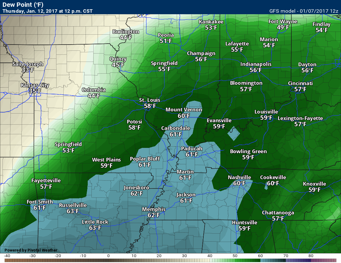
Another concern will be thunderstorms and heavy rain. Guidance indicates temperatures will rise into the 60’s on Thursday. Dew points will rise, as well. Strong wind fields. This is a recipe for storms.
Dew points on the GFS for Thursday and Friday. Anything from 58 and above is a red flag for heavier thunderstorms.
Temperatures for Thursday and Friday. Warm if the GFS is correct.

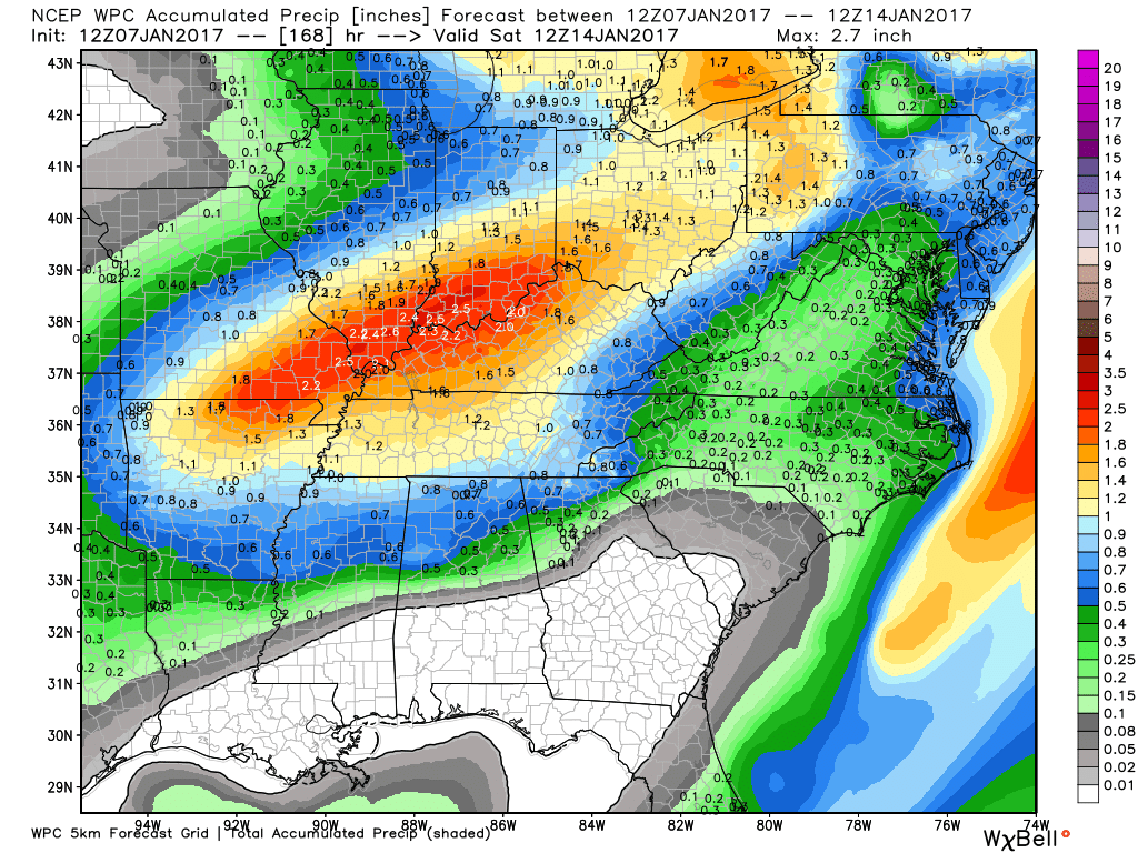
Some of the guidance packages are spitting out large rain totals for the middle and end of next week. Flash flooding concerns might rise if some of the model guidance is correct.
WPC is starting to paint some totals in the 1.5 to 2.5″ range.
I have the feeling the weatherman is going to be busy over the coming ten days.
I am tracking EIGHT events in the winter weather outlook. Busy.
Winter weather outlooks will be posted on the www.weathertalk.com website. Look under the Daily Weather Summary tab. These are updated at least twice each week.
For more information visit BeauDodsonWeather.com
If you would like to receive a text notification, when the winter weather outlooks are updated, then make sure you have opted in to text option three. The text options are found under the Personal Notification Settings tab on the weathertalk.com page.

Find me on Twitter
How much rain is expected over the coming days?
Monday night through Tuesday night you can expect 0.25″ to 0.50″
North view and south view
Click to enlarge

Heavier totals are likely as we push into Tuesday night through Friday. Several inches of rain could occur for some of my forecast counties. Monitor updates as we move forward.
Click enlarge
High and Low-Temperature Outlook
Sunday morning low temperatures.

Sunday afternoon high temperatures
Monday morning low temperatures.
Monday afternoon high temperatures
Monday temperatures might be a few degrees warmer

Severe thunderstorm outlook.
Remember that a severe thunderstorm is defined as a thunderstorm that produces 58 mph winds or higher, quarter size hail or larger, and/or a tornado.
Sunday through Monday night: Severe weather is not anticipated
Tuesday through Tuesdasy night: Lightning possible. Monitor updated forecasts.
Wednesday through Wednesday night: Severe weather is not anticipated
Thursday and Thursday night: Monitor updates. Storms are possible.
Friday and Friday night: Monitor updates.

We have regional radars and local city radars – if a radar does not seem to be updating then try another one. Occasional browsers need their cache cleared. You may also try restarting your browser. That usually fixes the problem. Occasionally we do have a radar go down. That is why I have duplicates. Thus, if one fails then try another one.
If you have any problems then please send me an email beaudodson@usawx.com
WEATHER RADAR PAGE – Click here —
We also have a new national interactive radar – you can view that radar by clicking here.
Local interactive city radars include St Louis, Mt Vernon, Evansville, Poplar Bluff, Cape Girardeau, Marion, Paducah, Hopkinsville, Memphis, Nashville, Dyersburg, and all of eastern Kentucky – these are interactive radars. Local city radars – click here
Regional Radar
 .
.
.

Live Lightning Data – zoom and pan: Click here
Live Lightning Data with sound (click the sound button on the left side of the page): Click here

No major changes to the forecast.

Bitterly cold nights ahead of us. Day’s will also be cold. Frost bite is always a concern is this type of weather..
Monitoring the southern snow system. This should remain south of most of the area. I will monitor the Missouri Bootheel and western Tenenssee.


 The latest 8-14 day temperature and precipitation outlook. Note the dates are at the top of the image. These maps DO NOT tell you how high or low temperatures or precipitation will be. They simply give you the probability as to whether temperatures or precipitation will be above or below normal.
 .
..


Who do you trust for your weather information and who holds them accountable?I have studied weather in our region since the late 1970’s. I have 38 years of experience in observing our region’s weather patterns.
I hold a Bachelor’s of Science in Geosciences with a concentration in Broadcast Meteorology. I graduated from Mississippi State University.
My resume includes the following:
Member of the American Meteorological Society.
NOAA Weather-Ready Nation Ambassador.
I am the owner and operator of Weather Talk (in partnership with The Fire Horn)
I own and operate the Southern Illinois Weather Observatory.
Recipient of the Mark Trail Award, WPSD Six Who Make A Difference Award, Kentucky Colonel, and the Caesar J. Fiamma” Award from the American Red Cross.
I am a recipient of the Mark Trail Award, WPSD Six Who Make A Difference Award, Kentucky Colonel, and the Caesar J. Fiamma” Award from the American Red Cross. In 2009 I was presented with the Kentucky Office of Highway Safety Award. I was recognized by the Kentucky House of Representatives for my service to the State of Kentucky leading up to several winter storms and severe weather outbreaks.
I am also President of the Shadow Angel Foundation which serves portions of western Kentucky and southern Illinois.
There is a lot of noise on the internet. A lot of weather maps are posted without explanation. Over time you should learn who to trust for your weather information.
My forecast philosophy is simple…
- Communicate in simple terms
- To be as accurate as possible within a reasonable time frame before an event
- Interact with you on Twitter, Facebook, email, and the blog
- Minimize the “hype” that you might see on television or through other weather sources
- Push you towards utilizing wall-to-wall LOCAL TV coverage during severe weather events

Many of my graphics are from www.weatherbell.com – a great resource for weather data, model data, and more

You can sign up for my AWARE email by clicking here I typically send out AWARE emails before severe weather, winter storms, or other active weather situations. I do not email watches or warnings. The emails are a basic “heads up” concerning incoming weather conditions.