
.
January 7, 2018
Sunday afternoon forecast
Forecast: Cloudy. Rain developing. A few sleet pellets mixed in with the rain (early on).
Temperatures: MO ~ 34 to 45 IL ~ 34 to 44 KY ~ 38 to 48 (colder near KY/IN border). Warmest over far western Kentucky.
What is the chance of precipitation? MO ~ 80% IL ~ 80% KY ~ 80% TN ~ 80%
Coverage of precipitation: Becoming widespread later this afternoon and evening
Wind chill values: 28 to 38
Accumulating snow or ice: Unlikely.
Winds: South wind 7 to 14 mph with gusts to 25 mph
What impacts are anticipated from the weather? Wet roadways.
My confidence in the forecast verifying: High
Is severe weather expected? No
The NWS defines severe weather as 58 mph wind or great, 1″ hail or larger, and/or tornadoes
Should I cancel my outdoor plans? Have a plan B during the afternoon and evening hours.
.
January 7, 2018
Sunday Night Forecast Details
Forecast: Cloudy with rain. Breezy. Steady temperatures.
Temperatures: MO ~ 34 to 44 IL ~ 34 to 44 KY ~ 35 to 44
What is the chance of precipitation? MO ~ 100% IL ~ 100% KY ~ 100% TN ~ 100%
Coverage of precipitation: Widespread
Wind chill values: 30 to 40
Accumulating snow or ice: Most of the precipitation should be rain.
Winds: South and southeast wind 10 to 20 mph with gusts to 30 mph
What impacts are anticipated from the weather? Wet roadways.
My confidence in the forecast verifying: Medium
Is severe weather expected? No
The NWS defines severe weather as 58 mph wind or great, 1″ hail or larger, and/or tornadoes
Should I cancel my outdoor plans? Have a plan B
.
January 8, 2018
Monday Forecast Details
Forecast: Cloudy. Morning showers possible. Showers ending as the day wears on.
Temperatures: MO ~ 37 to 42 IL ~ 37 to 42 KY ~ 38 to 44
What is the chance of precipitation? MO ~ 30% IL ~ 40% KY ~ 50% TN ~ 50%
Coverage of precipitation: Scattered (mainly early)
Wind chill values: 35 to 40
Accumulating snow or ice: No
Winds: North and northwest at 5 to 10 mph
What impacts are anticipated from the weather? Wet roadways
My confidence in the forecast verifying: High
Is severe weather expected? No
The NWS defines severe weather as 58 mph wind or great, 1″ hail or larger, and/or tornadoes
Should I cancel my outdoor plans? Have a plan B during the morning hours
.
Monday Night Forecast Details:
Forecast: Cloudy. Chilly. Patchy fog, drizzle, and freezing drizzle possible. I will monitor the potential of freezing drizzle.
Temperatures: MO ~ 28 to 34 IL ~ 28 to 34 KY ~ 32 to 35
What is the chance of precipitation? MO ~ 20% IL ~ 20% KY ~ 20% TN ~ 20%
Coverage of precipitation: Isolated
Wind chill values: 15 to 25
Accumulating snow or ice: Monitor updates on drizzle
Winds: Variable wind at 5 to 10 mph
What impacts are anticipated from the weather? Fog may reduce visibility. I will monitor the freezing drizzle potential.
My confidence in the forecast verifying: Medium
Is severe weather expected? No
The NWS defines severe weather as 58 mph wind or great, 1″ hail or larger, and/or tornadoes
Should I cancel my outdoor plans: No
.
January 9, 2018
Tuesday Forecast Details
Forecast: A mix of sun and clouds. Isolated shower possible.
Temperatures: MO ~ 42 to 46 IL ~ 42 to 46 KY ~ 44 to 48
What is the chance of precipitation? MO ~ 10% IL ~ 10% KY ~ 10% TN ~ 10%
Coverage of precipitation: Isolated
Wind chill values: N/A
Accumulating snow or ice: No
Winds: West and southwest wind 5 to 10 mph
What impacts are anticipated from the weather? None to isolated wet roadways.
My confidence in the forecast verifying: High
Is severe weather expected? No
The NWS defines severe weather as 58 mph wind or great, 1″ hail or larger, and/or tornadoes
Should I cancel my outdoor plans? No
.
Tuesday Night Forecast Details:
Forecast: Mostly cloudy. Fog possible. Drizzle or light showers possible. Steady or slowly rising temperatures.
Temperatures: MO ~ 38 to 44 IL ~ 36 to 42 KY ~ 38 to 44
What is the chance of precipitation? MO ~ 30% IL ~ 30% KY ~ 30% TN ~ 30%
Coverage of precipitation: Scattered
Wind chill values: 30 to 40
Accumulating snow or ice: No
Winds: East and southeast becoming south and southeast wind at 5 to 10 mph
What impacts are anticipated from the weather? Perhaps wet roadways and lower visibility in fog.
My confidence in the forecast verifying: Medium
Is severe weather expected? No
The NWS defines severe weather as 58 mph wind or great, 1″ hail or larger, and/or tornadoes
Should I cancel my outdoor plans: No
.
January 10, 2018
Wednesday Forecast Details
Forecast: Morning fog possible. Mostly cloudy. A few showers possible.
Temperatures: MO ~ 55 to 60 IL ~ 55 to 60 KY ~ 55 to 60
What is the chance of precipitation? MO ~ 30% IL ~ 20% KY ~ 20% TN ~ 20%
Coverage of precipitation: Spotty
Wind chill values: N/A
Accumulating snow or ice: No
Winds: South wind 5 to 10 mph
What impacts are anticipated from the weather? A few wet roadways possible
My confidence in the forecast verifying: Medium
Is severe weather expected? No
The NWS defines severe weather as 58 mph wind or great, 1″ hail or larger, and/or tornadoes
Should I cancel my outdoor plans? No
.
Wednesday Night Forecast Details:
Forecast: Mostly cloudy. Milder. Showers possible.
Temperatures: MO ~ 48 to 54 IL ~ 48 to 54 KY ~ 48 to 54
What is the chance of precipitation? MO ~ 40% IL ~ 40% KY ~ 40% TN ~ 40%
Coverage of precipitation: Scattered
Wind chill values: N/A
Accumulating snow or ice: No
Winds: South winds at 8 to 16 mph
What impacts are anticipated from the weather? Wet roadways
My confidence in the forecast verifying: Medium
Is severe weather expected? No
The NWS defines severe weather as 58 mph wind or great, 1″ hail or larger, and/or tornadoes
Should I cancel my outdoor plans: No
.
January 11, 2018
Thursday Forecast Details
Forecast: Mostly cloudy. Rain showers likely. Milder. Windy. Temperatures may fall if the cold front arrives early.
Temperatures: MO ~ 55 to 60 IL ~ 55 to 60 KY ~ 55 to 60
What is the chance of precipitation? MO ~ 50% IL ~ 50% KY ~ 50% TN ~ 50%
Coverage of precipitation: Scattered
Wind chill values: N/A
Accumulating snow or ice: No
Winds: South at 10 to 20 mph winds may switch to west and northwest once the cold front passes.
What impacts are anticipated from the weather? Wet roadways
My confidence in the forecast verifying: Medium
Is severe weather expected? No
The NWS defines severe weather as 58 mph wind or great, 1″ hail or larger, and/or tornadoes
Should I cancel my outdoor plans? Have a plan B
.
Thursday Night Forecast Details:
Forecast: Cloudy. Rain. Turning colder. Rain may change to a wintry mix. Low confidence on that subject. Turning colder.
Temperatures: MO ~ 28 to 34 IL ~ 28 to 34 KY ~ 30 to 34
What is the chance of precipitation? MO ~ 60% IL ~ 60% KY ~ 60% TN ~ 60%
Coverage of precipitation: Perhaps widespread
Wind chill values: 25 to 35
Accumulating snow or ice: Monitor updates
Winds: Becoming west and northwest at 8 to 16 mph and gusty
What impacts are anticipated from the weather? Wet roadways. Monitor updates concerning wintry mix potential. Low confidence.
My confidence in the forecast verifying: LOW
Is severe weather expected? No
The NWS defines severe weather as 58 mph wind or great, 1″ hail or larger, and/or tornadoes
Should I cancel my outdoor plans: Have a plan B
Monitor Friday’s forecast. Some of the guidance shows a wintry mix. A bit early for certainties.
.

.
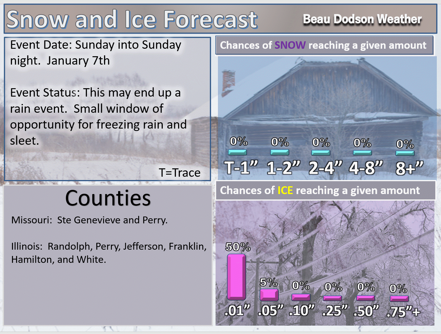
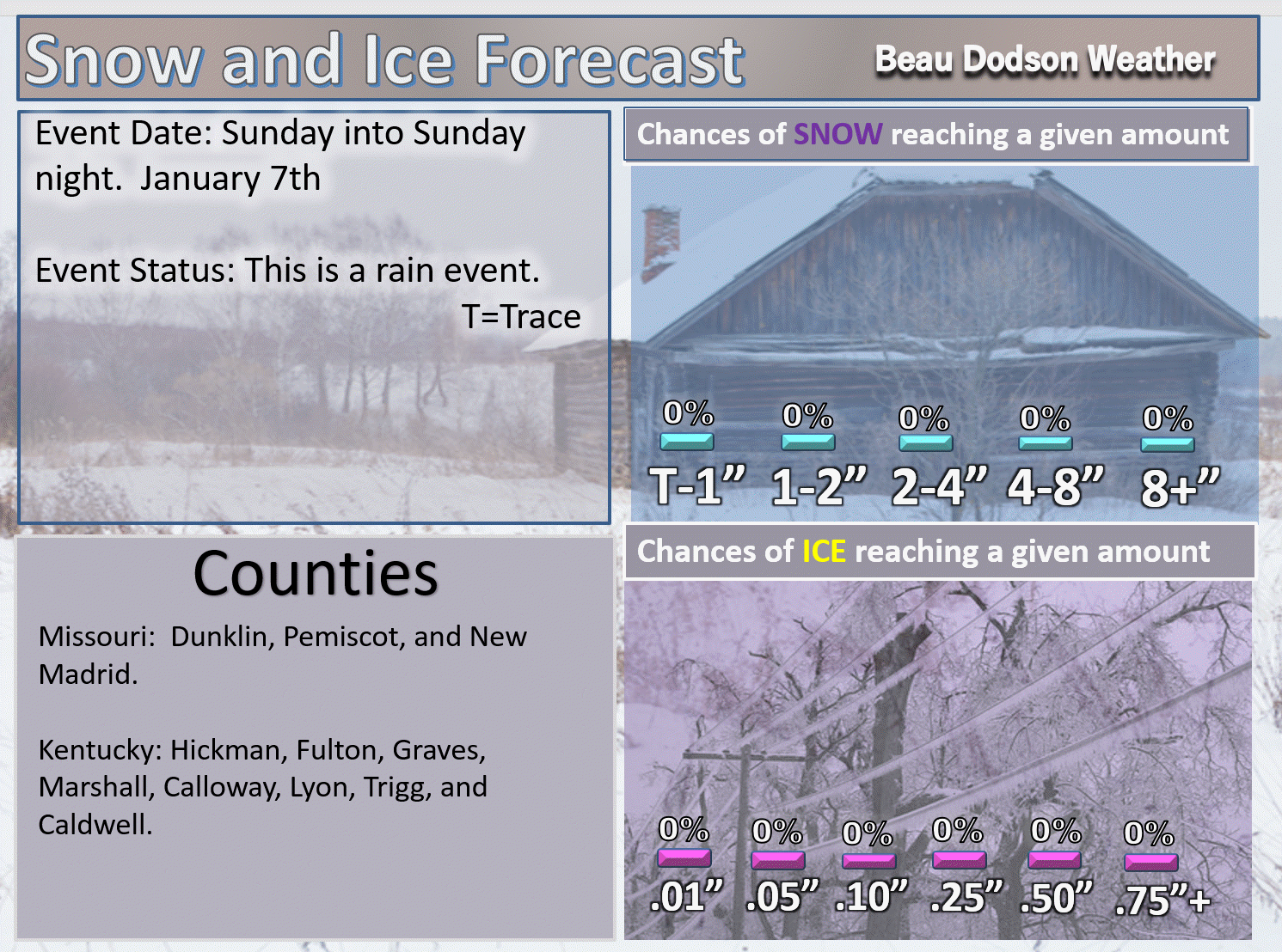
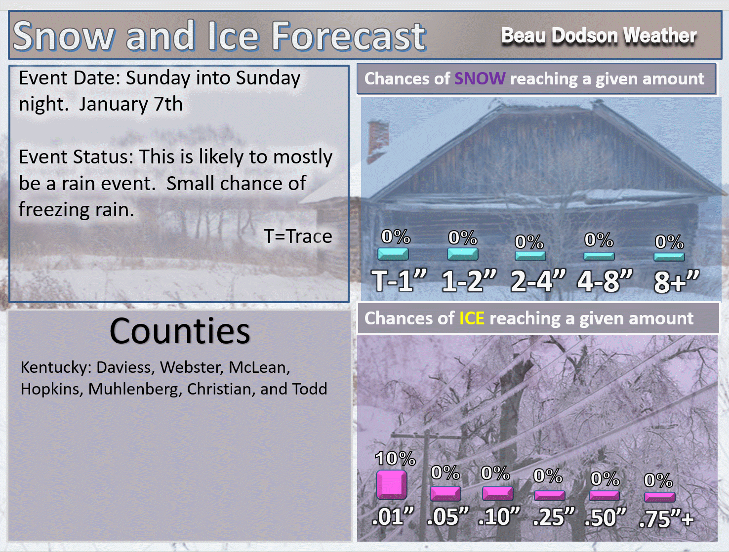
Sunday afternoon through Monday: A brief window of opportunity for freezing rain and sleet over portions of the area. For the most part, this is a rain event.
January 12th and 13th: Monitor updates. Another precipitation event is possible.
.

.
The National Weather Service definition of a severe thunderstorm is one that produces quarter size hail or larger, 58 mph winds or greater, and/or a tornado.
Now through next Friday: Severe storms are not anticipated.
.

Interactive Weather Radar Page. Choose the city nearest your location: Click this link
Forecast
Interactive Weather Radar Page. Choose the city nearest your location: Click this link
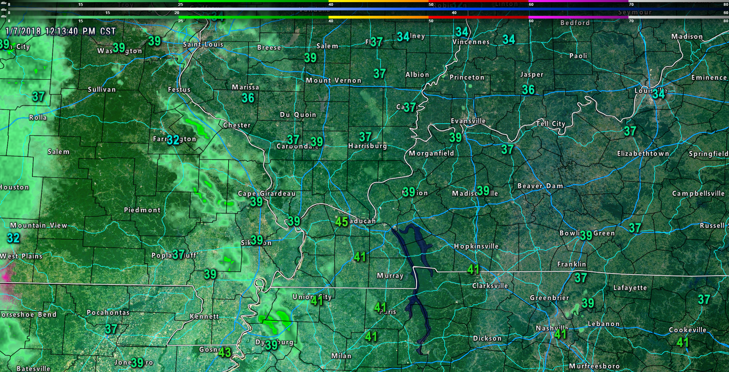
The main weather concern over the coming 24 hours will be tonight’s rain.
Temperatures have risen to 40+ degrees across portions of the area. This is great news as it will prevent any ice from forming.
This is mainly a rain event.
Here is the 12 PM temperature map. As you can see, well above freezing in most locations.
Click to enlarge images
.
.
Surfaces remain cold across our northern counties. Some patchy ice will be possible there. Officially there is a winter weather advisory for some of our counties. I think the window of opportunity for ice to develop is limited. Either way, use care as precipitation begins. Cold surfaces could produce a brief period of ice.
A few showers are possible Monday morning. Clouds will linger.
Isolated showers Tuesday and Tuesday night. Better rain chances arrive as we move into Wednesday and especially Wednesday night into Thursday night.
Colder air arrives Thursday night. The rain could change to a wintry mix. This will need to be monitored. Still a bit early to know if accumulating snow or ice will occur.
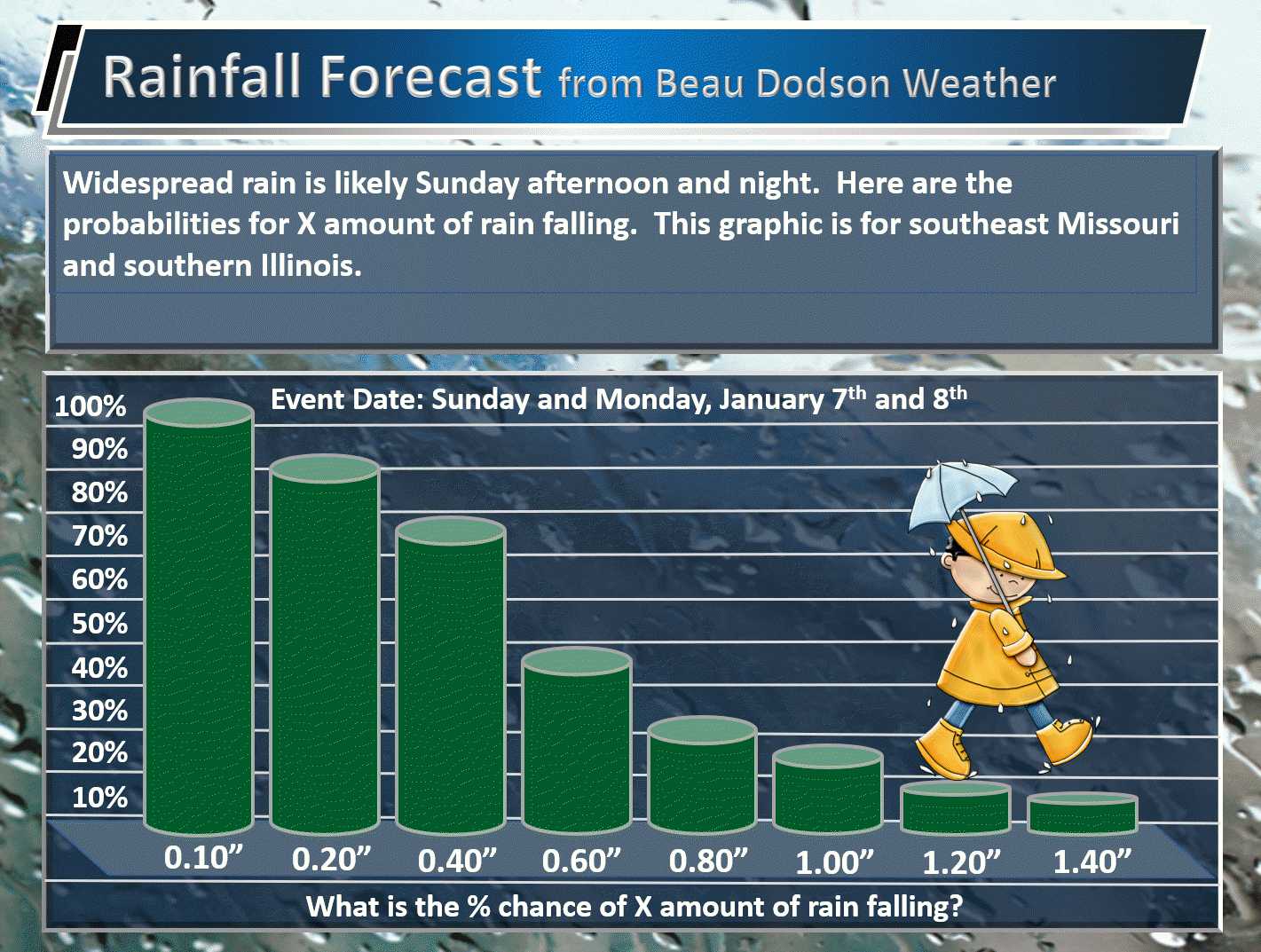
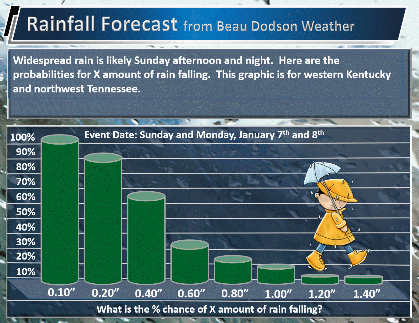
Here are my latest rain probability numbers. What is the % chance of X amount of rain falling.
This is for today into Monday morning.
Southeast MO and southern IL
.
.
Western KY and northwest TN
.
.
Here are my latest winter weather outlooks. Main concern is a brief period of freezing rain. This is mainly a rain event.
.


.


We offer regional radars and local city radars – if a radar does not update then try another one. Occasional browsers need their cache cleared. You may also try restarting your browser. This will usually fix any problems.
During the winter you can track snow and ice by clicking the winterize button on the local city view interactive radars.
You may email me at beaudodson@usawx.com
Interactive Weather Radar Page. Choose the city nearest your location: Click this link
National interactive radar: Click this link.