
Updated at 3 PM Thursday
January 4, 2018
Thursday Night Forecast Details:
Forecast: Increasing clouds. Snow showers or flurries possible.
Temperatures: MO ~ 4 to 10 IL ~ 2 to 8 KY ~ 5 to 10
What is the chance of precipitation? MO ~ 40% IL ~ 40% KY ~ 30% TN ~ 20%
Coverage of precipitation: Scattered
Wind chill values: -8 to 4 degrees above
Accumulating snow or ice: A dusting or less. Best chance of a dusting would be across the northern half of southeast Missouri and southern Illinois.
Winds: North and northwest at 5 to 10 mph
What impacts are anticipated from the weather? Cold wind chills. Slick roads if snow accumulates.
My confidence in the forecast verifying: High
Is severe weather expected? No
The NWS defines severe weather as 58 mph wind or great, 1″ hail or larger, and/or tornadoes
Should I cancel my outdoor plans: Cold wind chill values
.
January 5, 2018
Friday Forecast Details
Forecast: Mostly cloudy. A chance of flurries or snow showers.
Temperatures: MO ~ 25 to 30 IL ~ 18 to 25 KY ~ 22 to 26
What is the chance of precipitation? MO ~ 20% IL ~ 20% KY ~ 30% TN ~ 20%
Coverage of precipitation: Isolated
Wind chill values: 10 to 20
Accumulating snow or ice: A dusting or less
Winds: Variable at 4 to 8 mph
What impacts are anticipated from the weather? Early morning slick roads if the snow sticks.
My confidence in the forecast verifying: Medium
Is severe weather expected? No
The NWS defines severe weather as 58 mph wind or great, 1″ hail or larger, and/or tornadoes
Should I cancel my outdoor plans? No
.
Friday Night Forecast Details:
Forecast: Clouds early and then clearing. Bitterly cold.
Temperatures: MO ~ 7 to 14 IL ~ 2 to 8 KY ~ 5 to 10
What is the chance of precipitation? MO ~ 0% IL ~ 0% KY ~ 0% TN ~ 0%
Coverage of precipitation: Most likely none
Wind chill values: -5 to 10
Accumulating snow or ice: No
Winds: North and northast winds 5 to 10 mph
What impacts are anticipated from the weather? Cold wind chills
My confidence in the forecast verifying: High
Is severe weather expected? No
The NWS defines severe weather as 58 mph wind or great, 1″ hail or larger, and/or tornadoes
Should I cancel my outdoor plans: It will be quite cold
.
January 6, 2018
Saturday Forecast Details
Forecast: Mostly sunny.
Temperatures: MO ~ 26 to 32 IL ~ 25 to 30 KY ~ 25 to 30
What is the chance of precipitation? MO ~ 0% IL ~ 0% KY ~ 0% TN ~ 0%
Coverage of precipitation: None
Wind chill values: 20 to 30
Accumulating snow or ice: No
Winds: East 4 to 8 mph
What impacts are anticipated from the weather? None
My confidence in the forecast verifying: High
Is severe weather expected? No
The NWS defines severe weather as 58 mph wind or great, 1″ hail or larger, and/or tornadoes
Should I cancel my outdoor plans? No
.
Saturday Night Forecast Details:
Forecast: Partly cloudy. Precipitation should hold off until Sunday.
Temperatures: MO ~ 18 to 24 IL ~ 18 to 24 KY ~ 18 to 24
What is the chance of precipitation? MO ~ 20% (late) IL ~ 20% (late) KY ~ 10% TN ~ 10%
Coverage of precipitation: Most likely none. Small chance after 3 AM
Wind chill values: 15 to 20
Accumulating snow or ice: Most likely none. The precip should hold off until Sunday.
Winds: Southeast at 5 to 10 mph
What impacts are anticipated from the weather? Icy roads if sleet or freezing rain develops. Low chance.
My confidence in the forecast verifying: High
Is severe weather expected? No
The NWS defines severe weather as 58 mph wind or great, 1″ hail or larger, and/or tornadoes
Should I cancel my outdoor plans: No
.
January 7, 2018
Sunday Forecast Details
Forecast: Cloudy. Patchy freezing rain, sleet, and snow developing during the afternoon hours. I will need to monitor the timing of this event. Guidance is mixed. Most of the precipitation may hold off until late afternoon into Sunday night. Precipitation may change to all rain as temperatures will be on the rise.
Temperatures: MO ~ 32 to 36 IL ~ 32 to 36 KY ~ 32 to 36
What is the chance of precipitation? MO ~ 60% IL ~ 60% KY ~ 60% TN ~ 60%
Coverage of precipitation: Scattered
Wind chill values: 25 to 35
Accumulating snow or ice: Monitor updates. Some ice accumulation or snow accumulation is possible.
Winds: South wind 5 to 10 mph
What impacts are anticipated from the weather? Icy roads are possible.
My confidence in the forecast verifying: Medium
Is severe weather expected? No
The NWS defines severe weather as 58 mph wind or great, 1″ hail or larger, and/or tornadoes
Should I cancel my outdoor plans? Have a plan B
.
January 7, 2018
Sunday Forecast Details
Forecast: Cloudy. A mixture of rain, freezing rain, and sleet (questions remain on precip type). Precipitation may change to all rain as temperatures will be on the rise.
Temperatures: MO ~ 32 to 36 IL ~ 32 to 36 KY ~ 32 to 36
What is the chance of precipitation? MO ~ 60% IL ~ 60% KY ~ 60% TN ~ 60%
Coverage of precipitation: Widespread
Wind chill values: 25 to 35
Accumulating snow or ice: Monitor updates. Some ice accumulation or snow accumulation is possible.
Winds: South wind 5 to 10 mph
What impacts are anticipated from the weather? Icy roads can’t be ruled out.
My confidence in the forecast verifying: Medium
Is severe weather expected? No
The NWS defines severe weather as 58 mph wind or great, 1″ hail or larger, and/or tornadoes
Should I cancel my outdoor plans? Have a plan B
.
January 8, 2018
Monday Forecast Details
Forecast: Morning clouds. Becoming partly sunny. Rain showers possible early.
Temperatures: MO ~ 35 to 40 IL ~ 36 to 42 KY ~ 36 to 42
What is the chance of precipitation? MO ~ 30% IL ~ 30% KY ~ 40% TN ~ 30%
Coverage of precipitation: Scattered
Wind chill values: 30 to 40
Accumulating snow or ice: Most likely no.
Winds: Southwest and west wind 5 to 10 mph
What impacts are anticipated from the weather? Most likely none, but monitor updates.
My confidence in the forecast verifying: LOW
Is severe weather expected? No
The NWS defines severe weather as 58 mph wind or great, 1″ hail or larger, and/or tornadoes
Should I cancel my outdoor plans? Monitor updates.
.
Monday Night Forecast Details:
Forecast: Clearing. Chilly.
Temperatures: MO ~ 22 to 26 IL ~ 22 to 26 KY ~ 24 to 26
What is the chance of precipitation? MO ~ 0% IL ~ 0% KY ~ 0% TN ~ 0%
Coverage of precipitation: Most likely none
Wind chill values: 15 to 25
Accumulating snow or ice: No
Winds: North wind at 5 to 10 mph
What impacts are anticipated from the weather? None
My confidence in the forecast verifying: Medium
Is severe weather expected? No
The NWS defines severe weather as 58 mph wind or great, 1″ hail or larger, and/or tornadoes
Should I cancel my outdoor plans: No
.

.
Thursday night through Saturday: Flurries or snow showers are possible, but widespread accumulating snow is unlikely. There is a chance of a dusting across southeast Missouri and southern Illinois on Thursday night and Friday morning. Lesser chances the further south you travel.
Saturday night through Monday: I continue to monitor the chance of a wintry mix on Sunday and Sunday night. There remain questions about temperatures. Temperatures are forecast to rise above freezing on Sunday. The question is when. Freezing rain, sleet, and snow will be possible across the area.
It only takes a small amount of freezing rain to cause icy roads. Roads are very cold.
.

.
The National Weather Service definition of a severe thunderstorm is one that produces quarter size hail or larger, 58 mph winds or greater, and/or a tornado.
Now through next Thursday: Severe storms are not anticipated.
.

Interactive Weather Radar Page. Choose the city nearest your location: Click this link
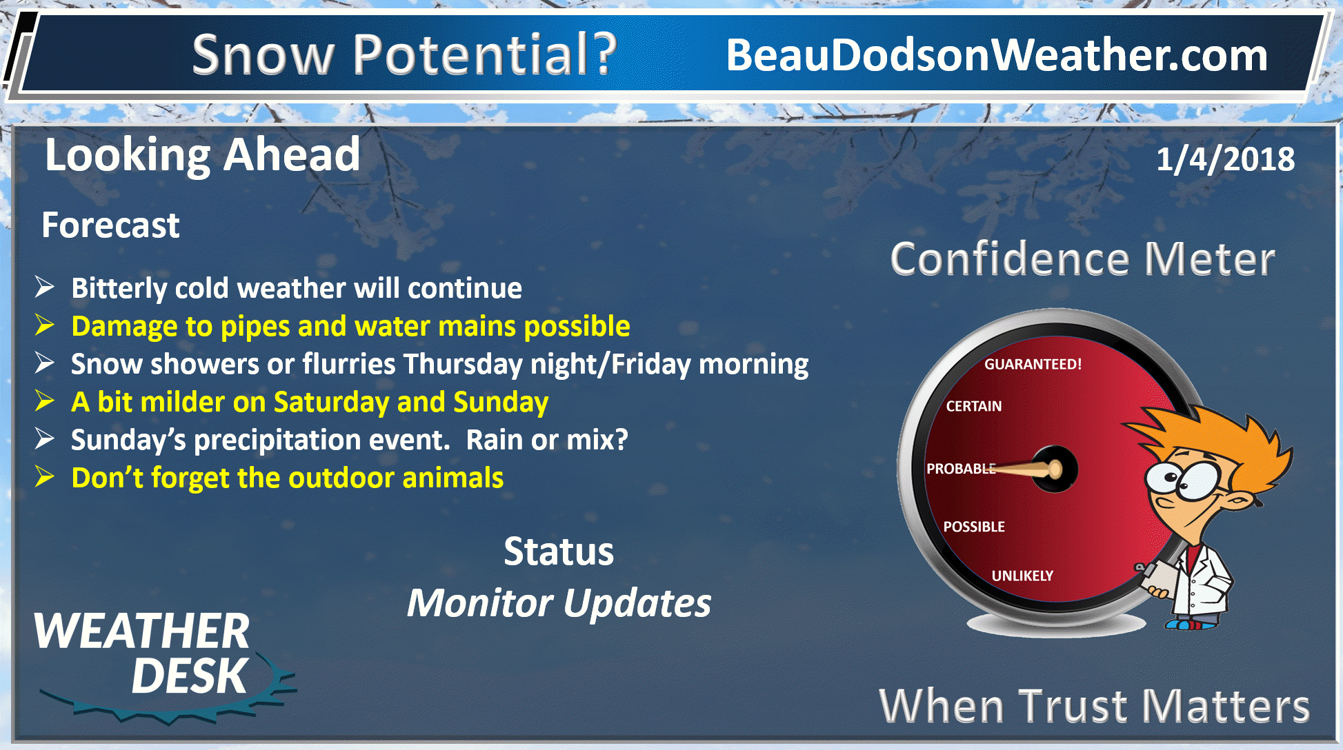
Well, the cold weather just keeps on coming!
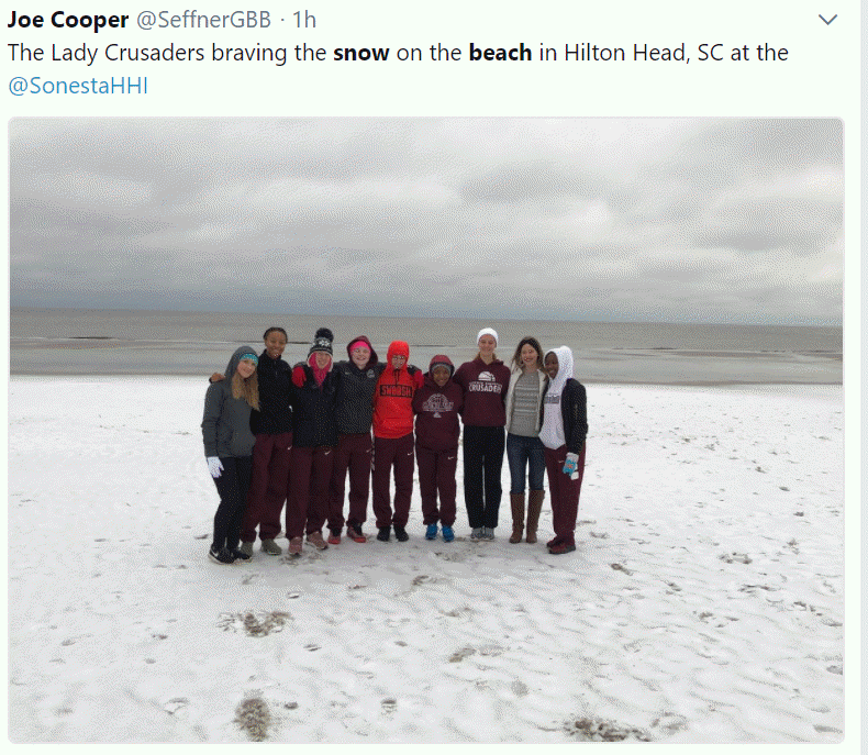
Did you see the photographs of snow in Florida? Snow at the beaches along the East Coast? Blizzard warnings for Virginia Beach. Amazing.
This is the second southern snow storm in the last few weeks. Yet, we still can’t seem to drum up more than a few snow flurries.
Here is a photo I found on Twitter. This is Hilton Head, South Carolina. At the beach, no less!
.
.
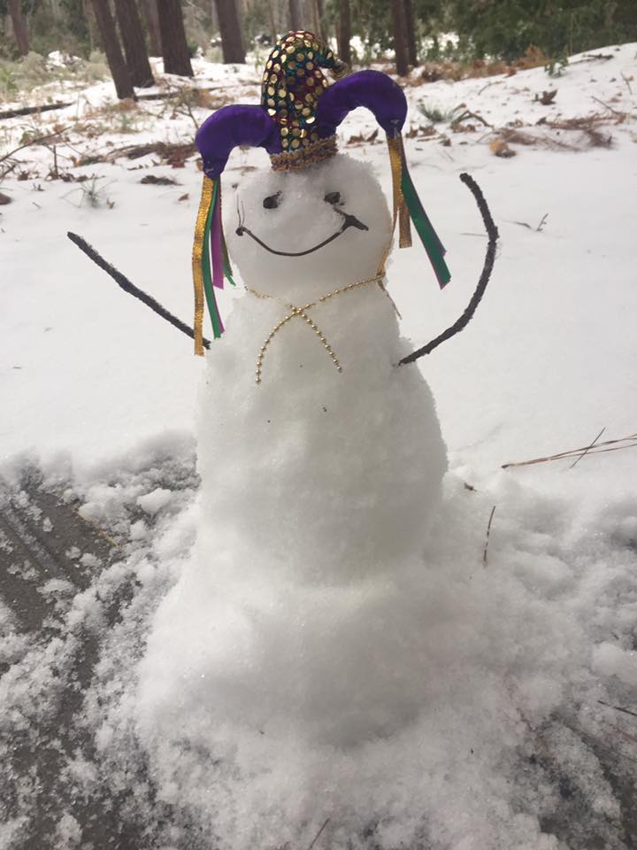
This next photo was sent to Bailey Wolfe from her family in Hilton Head. Amazing!
.
.
Not everyday you see snow in Florida!
.
.
We are stuck with more cold weather over the coming days.
A weak disturbance will pass through the region on Thursday night and Friday morning. Some clouds will accompany the disturbance. There is a chance of some flurries or snow showers. I can’t rule out a trace to a dusting or so of snow. The main area of concern would be northern portions of southeast Missouri into southern Illinois. Lesser chances south and southeast.
We will continue to be cold on Friday with highs in the 20’s. Lows Friday night will dip back into the single digits over most of the region.
Saturday will also be cold. Not the best day for anything outside. Highs in the 20’s are anticipated.
A stronger system arrives on Sunday/Sunday night. Precipitation should spread into our region from the west and southwest.
We may remain dry Saturday night into Sunday morning. There is a question on the time of the wintry precipitation. The trend has been for a slower arrival time.
Cold air will be in place as the precipitation arrives. You can expect a wintry mix of freezing rain and sleet. Perhaps snow, as well. Either way, a mix of precipitation.
Temperatures will be on the rise Sunday, but how much of a rise? That is the question.
The ground is cold and roads are cold. If rain falls on these surfaces it would likely freeze.
Slick roads are possible Sunday/Sunday night. We need to monitor temperatures. At some point, we should push above freezing.
The track of strength of the system has not been handled all that well by the model guidance.
Historically, cold air masses are slow to leave. It is possible, if the system is strong enough, for warm air advection to win out. That would mean the wintry mix would quickly change to all rain.
If the system is weaker it might have a more difficult time pulling in the warmer air.
I would encourage everyone to monitor updates moving forward. The forecast confidence on precipitation type remains low.
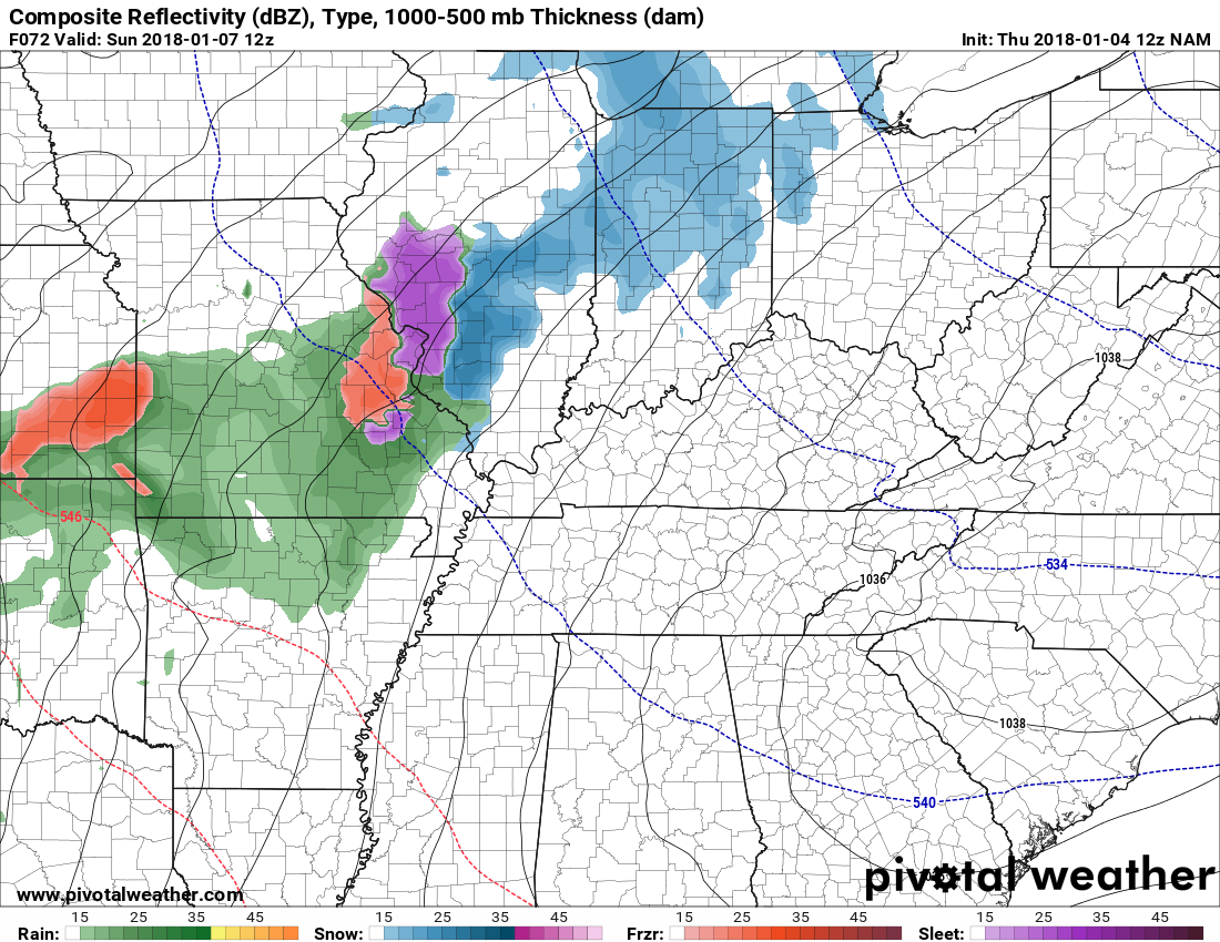
Here is the NAM model 6 AM on Sunday. Temperatures.
.

.
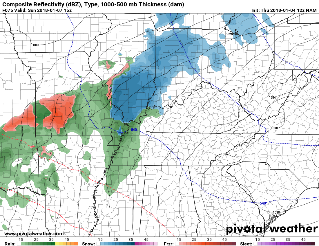
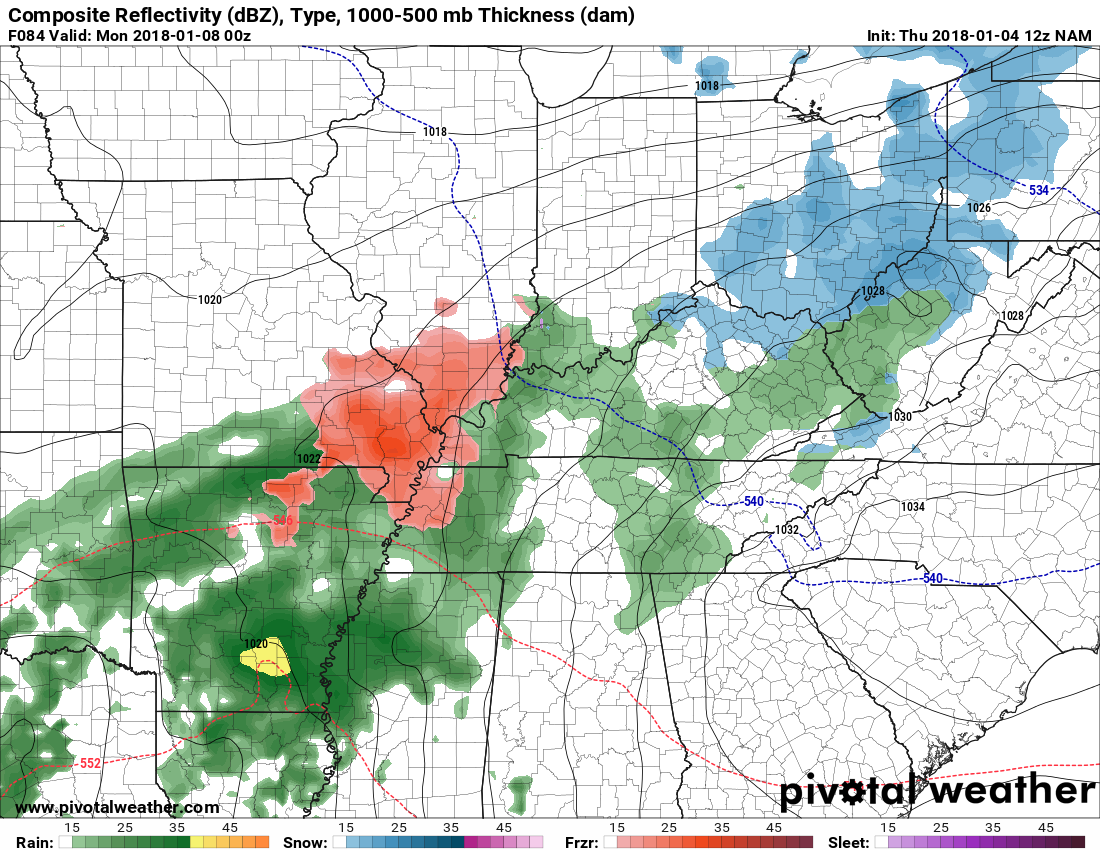
The NAM model guidance is starting to show the precipitation on Sunday.
6 AM Sunday
Green is rain. Purple is freezing rain and sleet. Blue would be snow.
One models opinion on Sunday. Confidence remains low on the timing of precipitation arrival.
.
9 AM Sunday
12 PM Sunday

6 PM Sunday
.
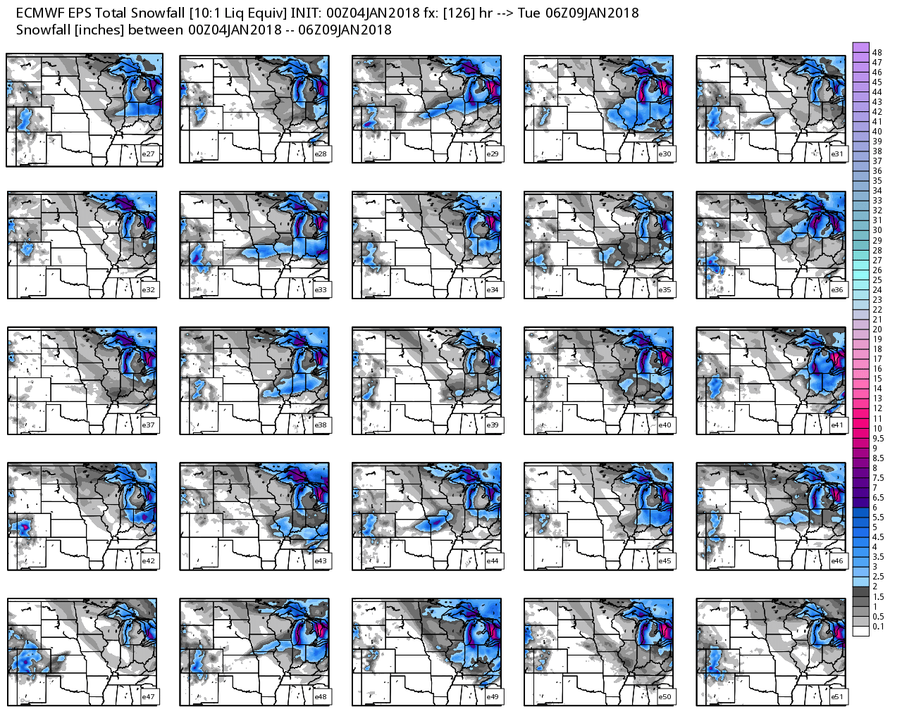
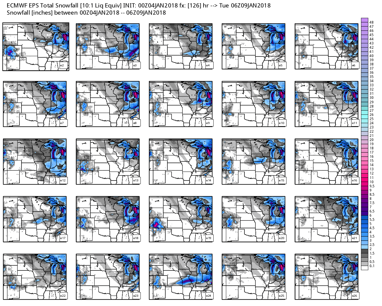
A few of the EC guidance ensemble members have snow and ice on Sunday. This will need to be monitored.
A few EC ensemble members have snow/ice here on Sunday. This will need to be monitored.
Quite a few of the ensembles are showing the potential for frozen precipitation on Sunday. Again, confidence remains low.
.
.
.
.
Beau’s Winter Weather Outlook
It is important to remember that this pattern is fluid. There is always going to be lower than normal confidence, during the winter months, for the forecast past day three or four.
.
.
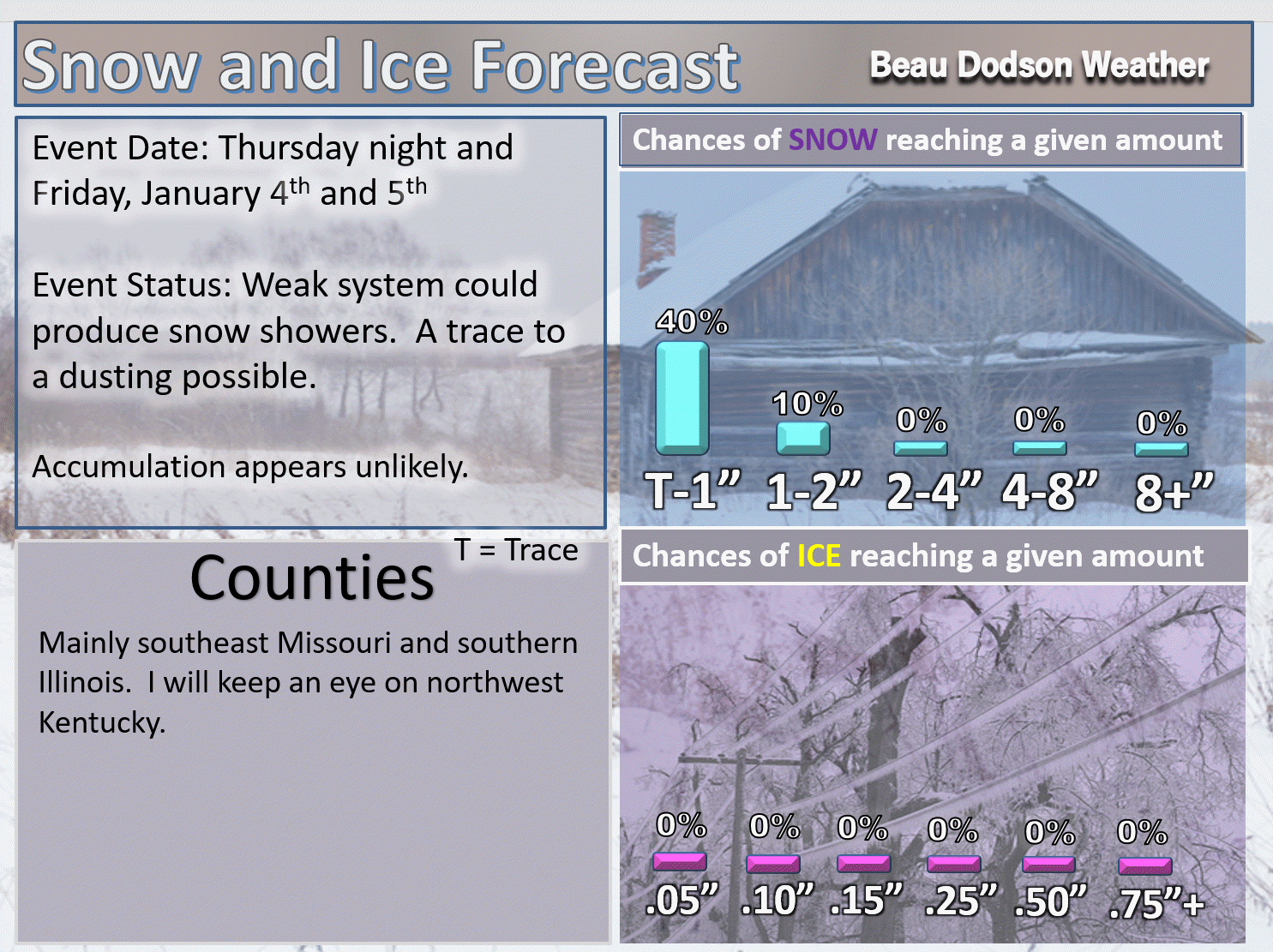
Here are my latest snow probability maps for the week ahead.
Breaking it down between snow and ice.
A weak system Thursday night into Friday morning will push into our region from the St Louis, MO area. Snow showers and flurries will be possible, especially across the northern half of southeast Missouri and southern Illinois. A bit more uncertain for western Kentucky. Small chance in west Tennessee.
Snow totals would be a trace to perhaps a dusting or so.
T-1″ means a trace to one inch.
.
.
The larger system arrives on Sunday. A mixture of freezing rain, sleet, and snow is likely to develop Sunday morning and afternoon. Icy roads are possible. The frozen precipitation could turn to rain, although this remains uncertain. Monitor updates.
Remember, it does not take much freezing rain to cause problems. A trace can cause icy roads.
T-1″ means a trace to one inch.
.

.
These have been updated with the latest data.
These graphics show you the % chance of one inch or more of snow and/or accumulating sleet and freezing rain.
I am monitoring Friday for flurries. The Sunday system is larger. Widespread rain or wintry mix is likely on Sunday. The timing of the event will need to be monitored. The frozen precipitation may change to all rain. Warmer air is forecast to move into the area during the weekend (esp on Sunday).
.

.
Next week
.

.


We offer regional radars and local city radars – if a radar does not update then try another one. Occasional browsers need their cache cleared. You may also try restarting your browser. This will usually fix any problems.
During the winter you can track snow and ice by clicking the winterize button on the local city view interactive radars.
You may email me at beaudodson@usawx.com
Interactive Weather Radar Page. Choose the city nearest your location: Click this link
National interactive radar: Click this link.