2:30 PM video update Thursday
10:15 AM Thursday Video Update
On and off snow showers will continue into this afternoon. Perhaps another dusting to an inch in spots.
I am monitoring activity moving in from Missouri. This is the 2nd round that I have been talking about.
Hazardous roads are being reported in many areas. It only takes a little bit of snow to caused problems. Thus, impact is more important than amounts.
Use care, as always.
THURSDAY MORNING VIDEO UPDATE
We have some great sponsors for the Weather Talk Blog. Please let our sponsors know that you appreciate their support for the Weather Talk Blog.
Milner and Orr Funeral Home and Cremation Services located in Paducah, Kentucky and three other western Kentucky towns – at Milner and Orr they believe in families helping families. You can find Milner and Orr on Facebook, as well.
![]()
.

Are you in need of new eye glasses? New contacts? Perhaps you need an eye exam. Then be sure and visit the Eye Care Associates of western Kentucky (the Paducah location).
For all of your families eye care needs. Visit their web-site here. Or, you can also visit their Facebook page.


Expressway Carwash and Express Lube are a locally owned and operated full service Carwash and Lube established in 1987. They have been proudly serving the community for 29 years now at their Park Avenue location and 20 years at their Southside location. They have been lucky enough to partner with Sidecar Deli in 2015, which allows them to provide their customers with not only quality service, but quality food as well. If you haven’t already, be sure to make Expressway your one-stop shop, with their carwash, lube and deli. For hours of operation and pricing visit www.expresswashlube.com or Expressway Carwash on Facebook.
.
.
Looking for some tasty holiday treats? Fluff Cupcakes has what you and your family need. Located in Benton, KY they deliver! I have used Fluff Cupcakes, during Thanksgiving and Christmas, for the last couple of years. I can tell you that the cupcakes are delicious. Be sure and contact Tracy and place your order. Birthdays, holidays, or just because!

Heath Health Foods is a locally owned and operated retail health and wellness store. Since opening in February 2006; the store has continued to grow as a ministry with an expanding inventory which also offers wellness appointments and services along with educational opportunities. Visit their web-site here. And. visit Heath Health Foods on Facebook!

If you are on this site then it means you are a paying customer to Weather Talk. If you are not a customer (because someone sent you the password) and would like to become one then visit www.weathertalk.com
If you want to receive the winter weather outlooks, via a text, then be sure and opt-in text option three (behind the Personal Notification Settings tab. It is the social media text for severe weather and winter weather). I will text you the link and password to the latest post.
Keep in mind that a normal work day for me is between 8 and 12 hours. During active weather, it is not uncommon for those hours to extend to 18 hours. I do not work for radio or television. I am a private meteorologist and work for you. The proceeds are used for web site maintenance, graphics, the interactive radars, the AWARE emails, the computer equipment to run all of this, the texting service, software, and my time. Proceeds are also used for a variety of local charities.
As always, your support is appreciated. Happy New Year! I hope you have a wonderful, prosperous, healthy year ahead.
Thank you
Beau Dodson
DISCLAIMER: If you are reading this winter weather outlook then it means you understand the complexities of winter forecasting.
Winter storm forecasting is difficult 12 to 24 hours in advance, let alone days in advance. Don’t skim the graphics. Read the commentary and actual forecast thoughts.
What you read here is for planning purposes only. There can be and often are wild fluctuations in model guidance past two or three days. Again, keep this in mind. Don’t say “Beau said it is going to snow on Thursday”
Confidence on snow events, past two or three days, is typically going to be low. Again, forecasters can not accurately predict snow totals more than 12 to 24 hours in advance.
If I tell you confidence is low then that means significant adjustments are possible in the forecast.
I issue the winter weather forecast for those who enjoy tracking winter storms. As long as we all understand that anything past two or three days is considered long range. This is especially true during the winter months with a fast jet stream flow.
Welcome to the winter weather outlook

An explanation of what is happening in the atmosphere over the coming days…
Today’s update is a video. It is easier for me to give you a video update than explain all the details in words.
COMING SOON!
1. Beau Dodson Weather App. The App will include the interactive radars. More importantly, the app is going to be used to push the text messages to your phone. There have been issues with Verizon over the past month. This is not acceptable when the information needs to be in your hands within seconds after I type out a message. This is most important during tornado outbreaks.
The app will receive the messages must faster than text messages. This is not going to be a bell’s and whistle’s app. This app will be for me to get my hand typed messages to you and your family faster. Stay tuned!
2. As many of you know, I run the Shadow Angel Foundation. We had quite a few people sign up in November and December. This means we are adding a new charity that the foundation will help. The charity will be the Guardian Family Services. This is located in Massac County and it serves six southern Illinois counties. More information here – Click here
We will continue to donate brand new GUND bears to Child Watch and PASAC. Both of those charities are located in western Kentucky. Our annual teddy bear costs are around $3000 to $4000 dollars. It varies each year based on how many bears they need.
3. Beau Dodson Weather Watcher program. Stay tuned!
Your support of the text messages is what helps pay for all of the above.
Thank you for your support!
More graphics further down in the blog. Here is the video update issued on Wednesday afternoon
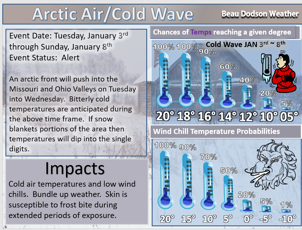
Tuesday, January 3rd through Sunday, January 8th
Concern: A cold front will sweep through the area on Tuesday and Tuesday night. Falling temperatures will accompany the front. There is a chance for some light rain showers with the front. I can’t rule out some flurries/novelty snowflakes. I believe most of the precipitation will end as the cold air arrives.
Impact? Wind chills will drop into the teens late Tuesday night into Sunday morning. If snow accumulates then temperatures will be a few degrees colder.
Confidence: High confidence on the cold air arriving Tuesday afternoon into Wednesday. The cold air will last through the weekend.
Confidence level on a scale from 1 to 10. One being the lowest confidence level. Ten being the highest confidence level.
Confidence level on the cold air arriving: 10
Changes since the last update: I have increased probabilities for colder temperatures. As you can see, we now have a 100% chance for temperatures to dip into the 18 to 20 degree range.
The coldest temperatures will likely be on Thursday, Friday, and Saturday nights.
If snow accumulates then temperatures will be a few degrees colder.
.
Let’s take a look at a few maps.
Low-temperature maps, wind chill maps, and high-temperature maps
This first image is for Wednesday 6 a.m.
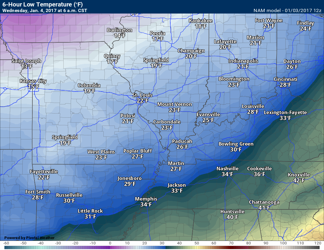
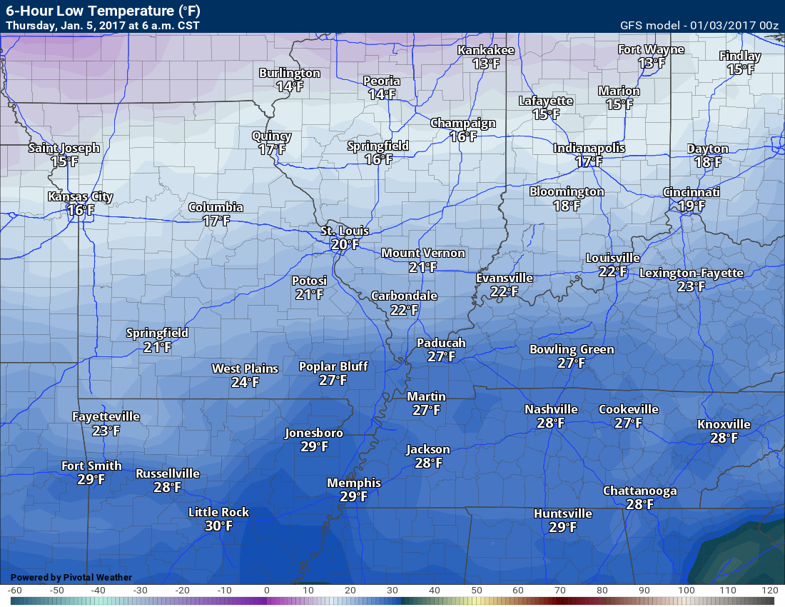
This next image is for Thursday at 6 a.m.
Air temperature
Temperatures could be a few degrees colder than NAM indicates.
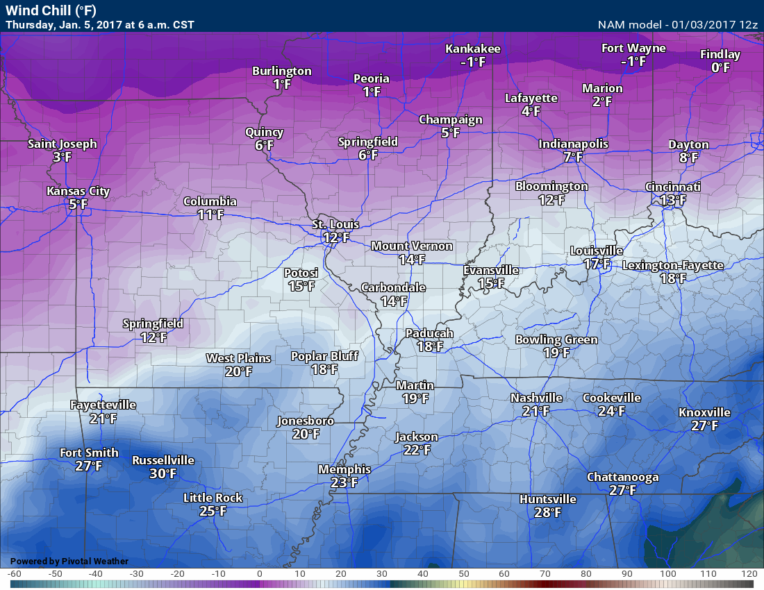
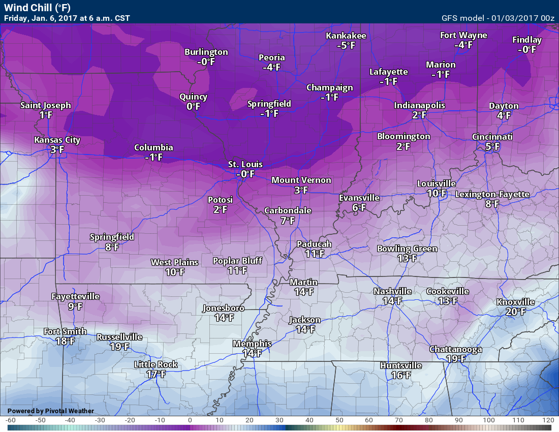
Thursday morning wind chills. Brrrrr Bundle up the kids weather.

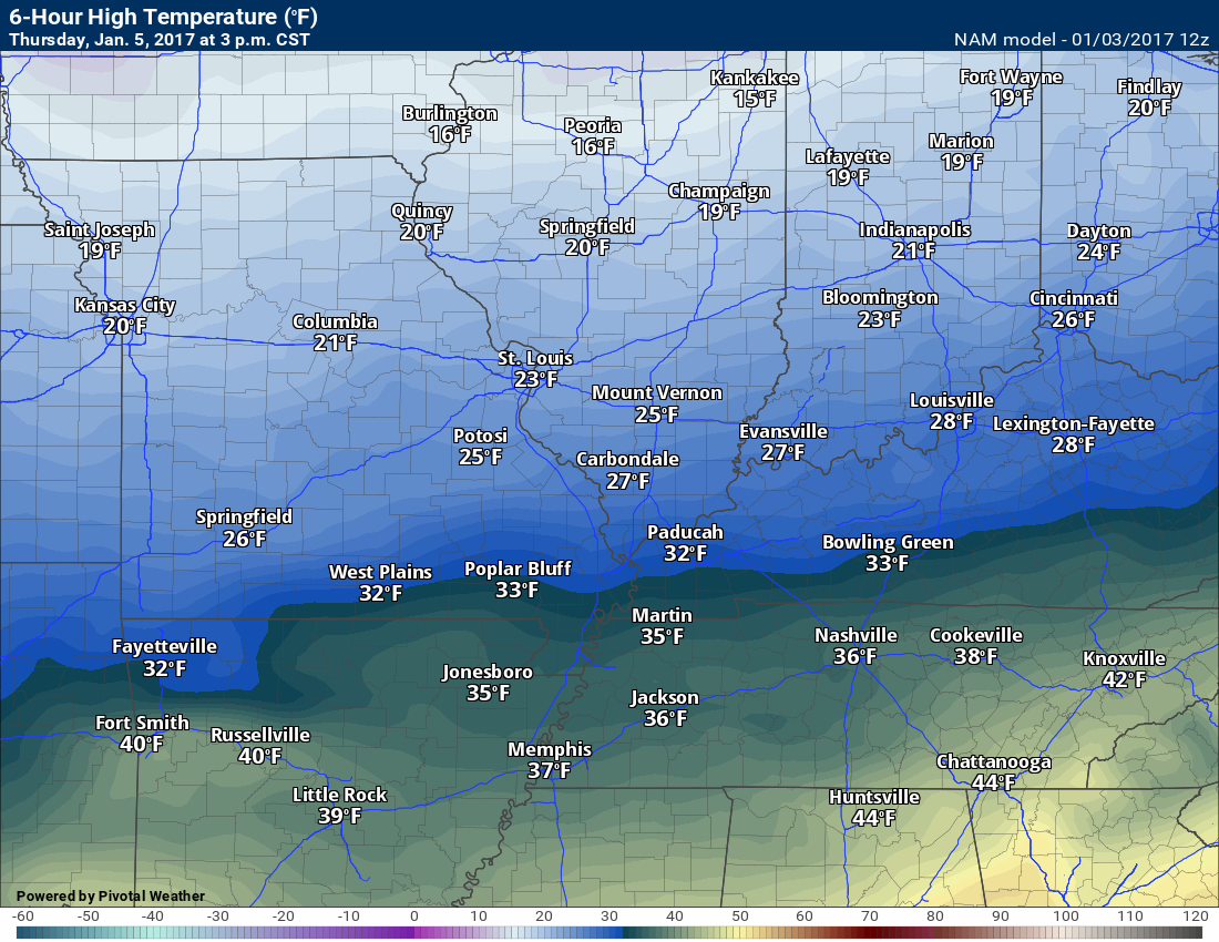
Thursday 3 p.m. air temperatures
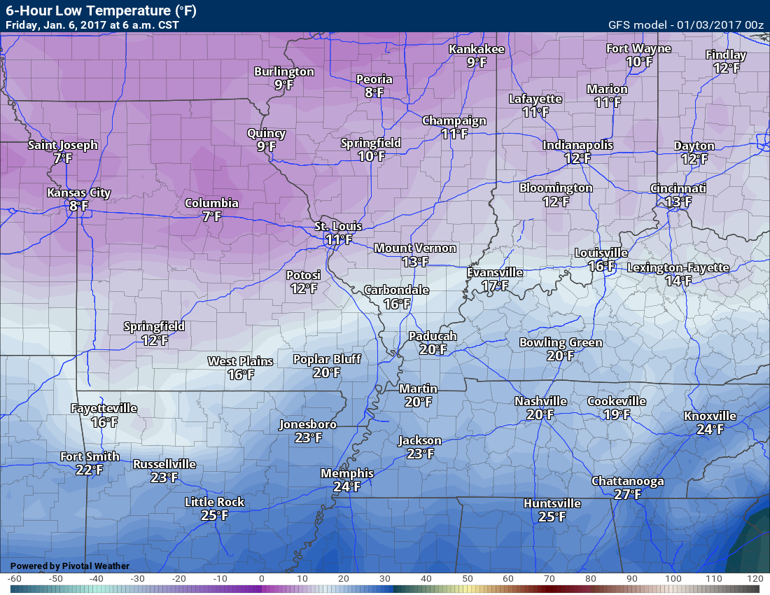
Friday morning low temperatures
Friday morning wind chills
Again, brrrr
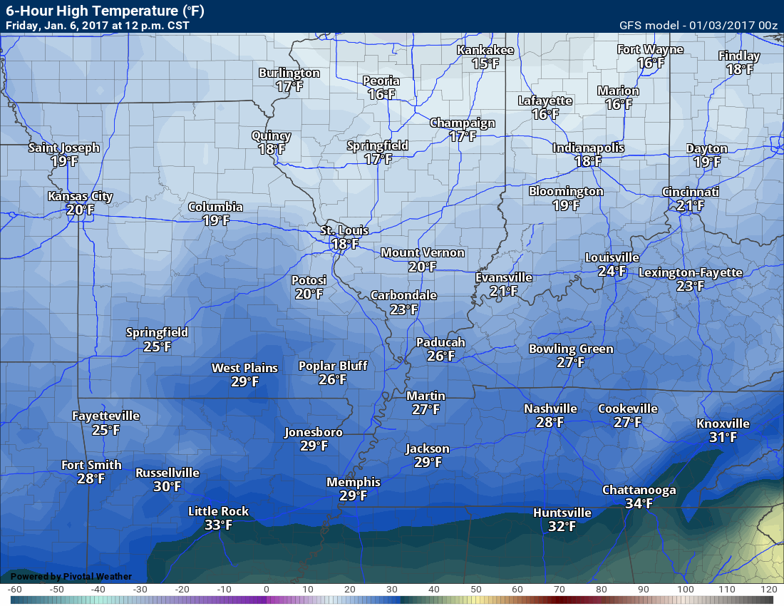
Friday 12 p.m. air temperatures
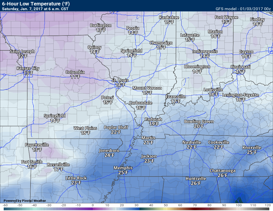
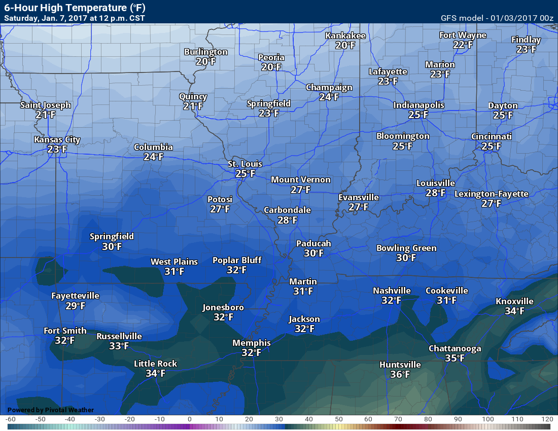
Saturday morning low temperatures
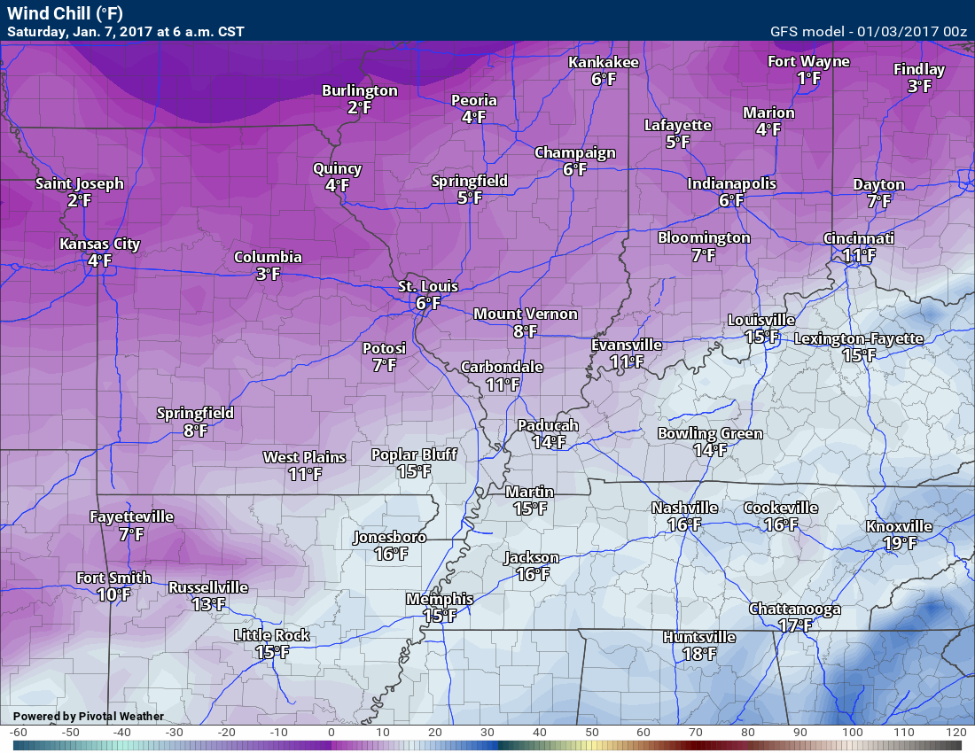
Saturday morning wind chills
Saturday 12 p.m. temperatures
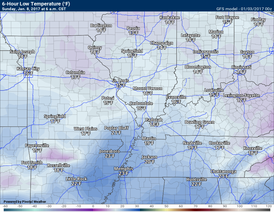
Sunday morning low temperatures
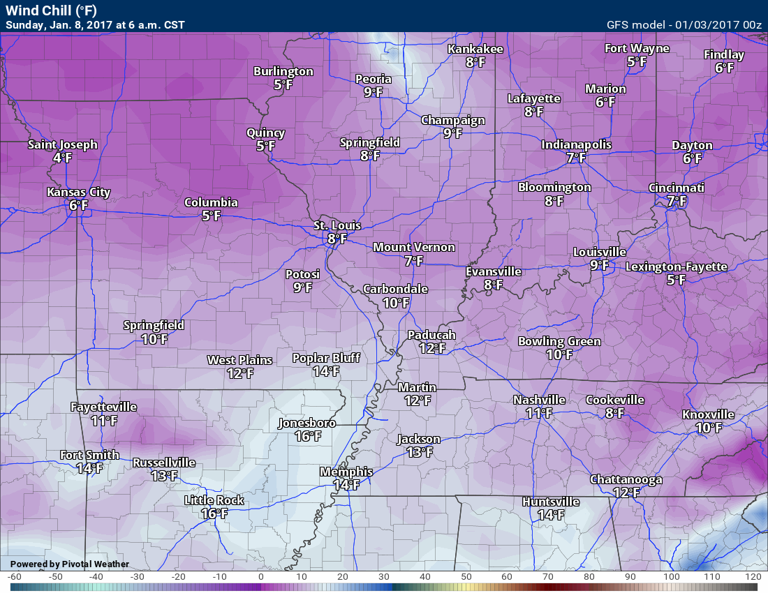
Sunday morning wind chills
Church-goers will want the heavy coats on Sunday.
Sunday afternoon temperatures. A bit warmer than previous days.
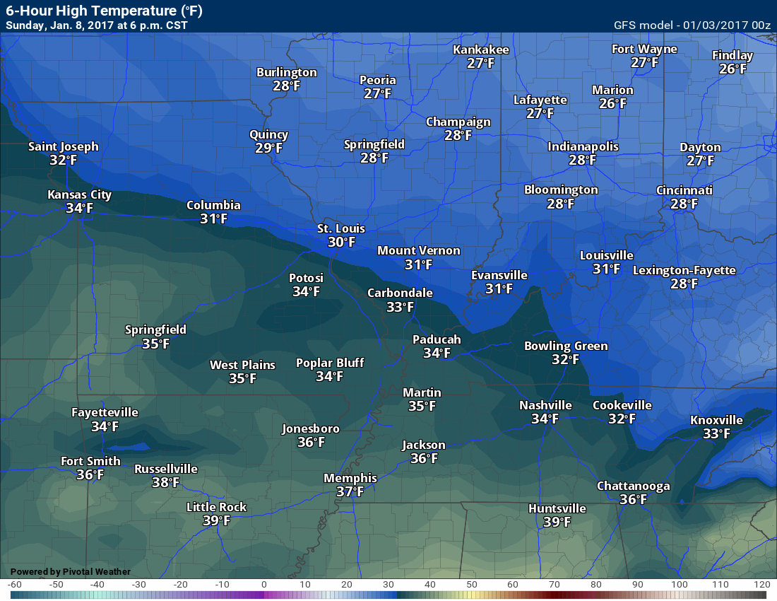
Keep in mind, these temperature maps will change if snow accumulates in the region.
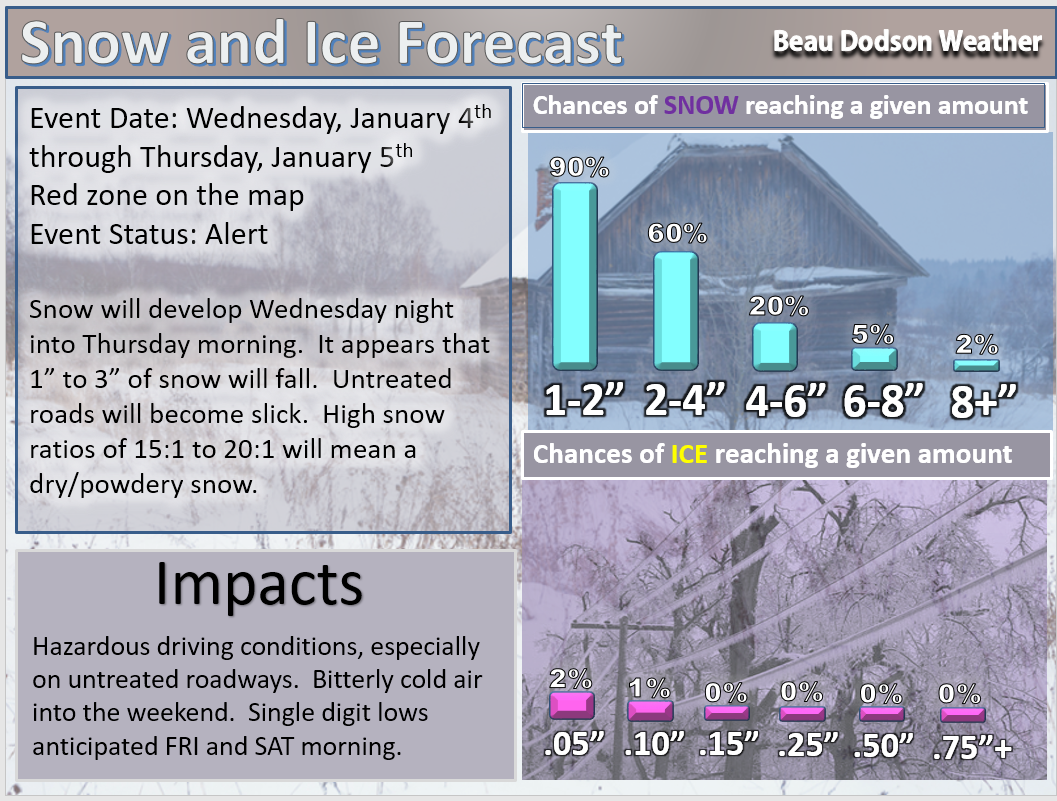
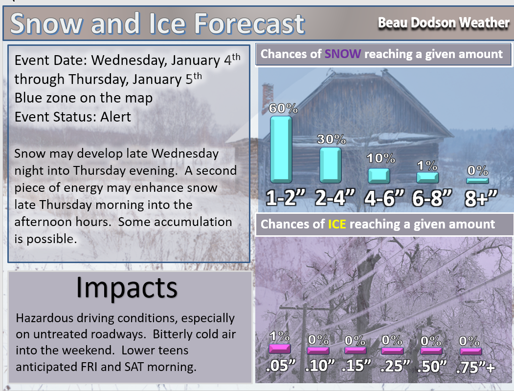
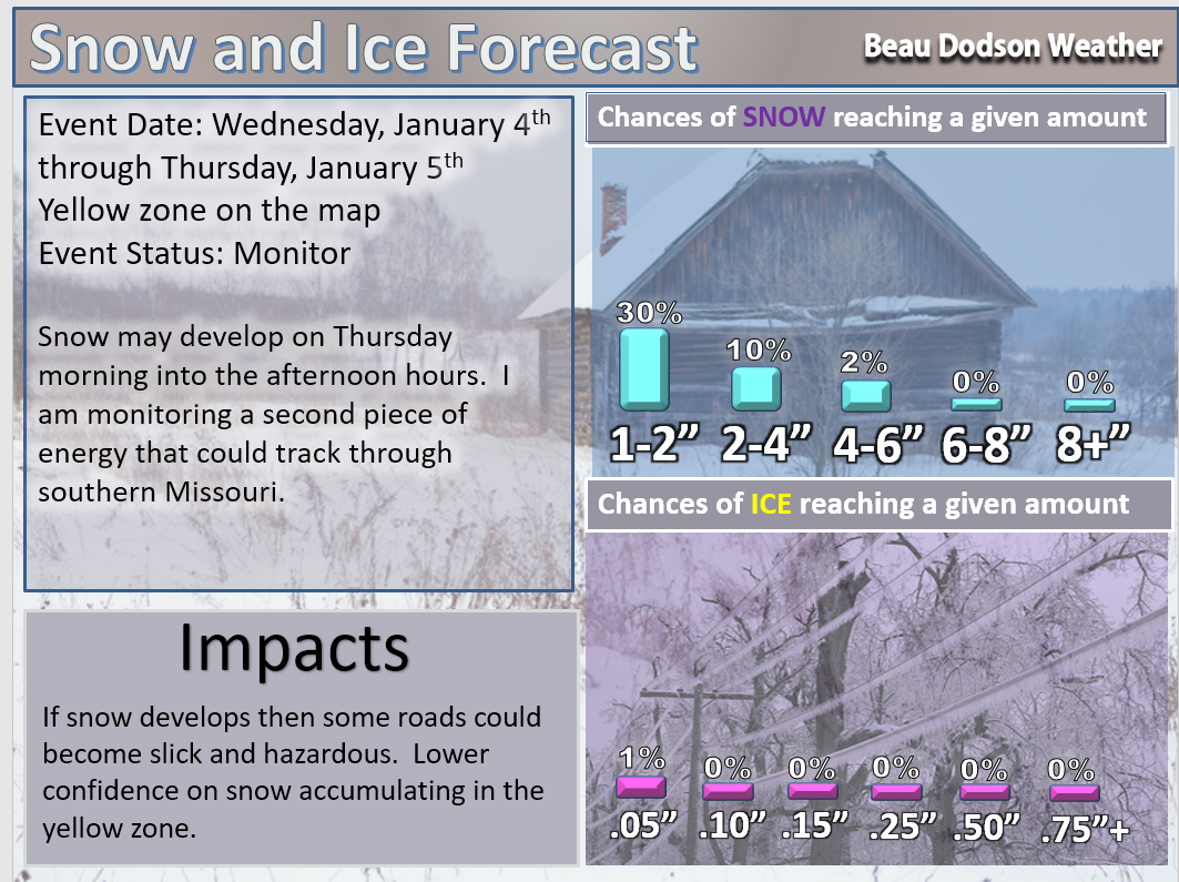
Wednesday night, January 4th through Thursday/evening January 5th
Concern: A weak weather system will pass through the region. The system will spread snow from Kansas into parts of Missouri late Wednesday night into Thursday morning. The disturbance will then push across our local area Thursday morning and afternoon/evening.
Impact? Hazardous driving conditions
Confidence: Medium to high confidence that snow flurries or snow showers develop late Wednesday night into Thursday evening.
Confidence level on a scale from 1 to 10. One being the lowest confidence level. Ten being the highest confidence level.
Confidence level on snow or wintry mix across at least some portion of our area: 8
Milk and Cookies with Beau? Possibly
9 PM Wednesday video update
3 PM Wednesday Video
Here is the snow forecast via graphics (please see video for details. The graphics don’t tell you the whole story)
Forecast
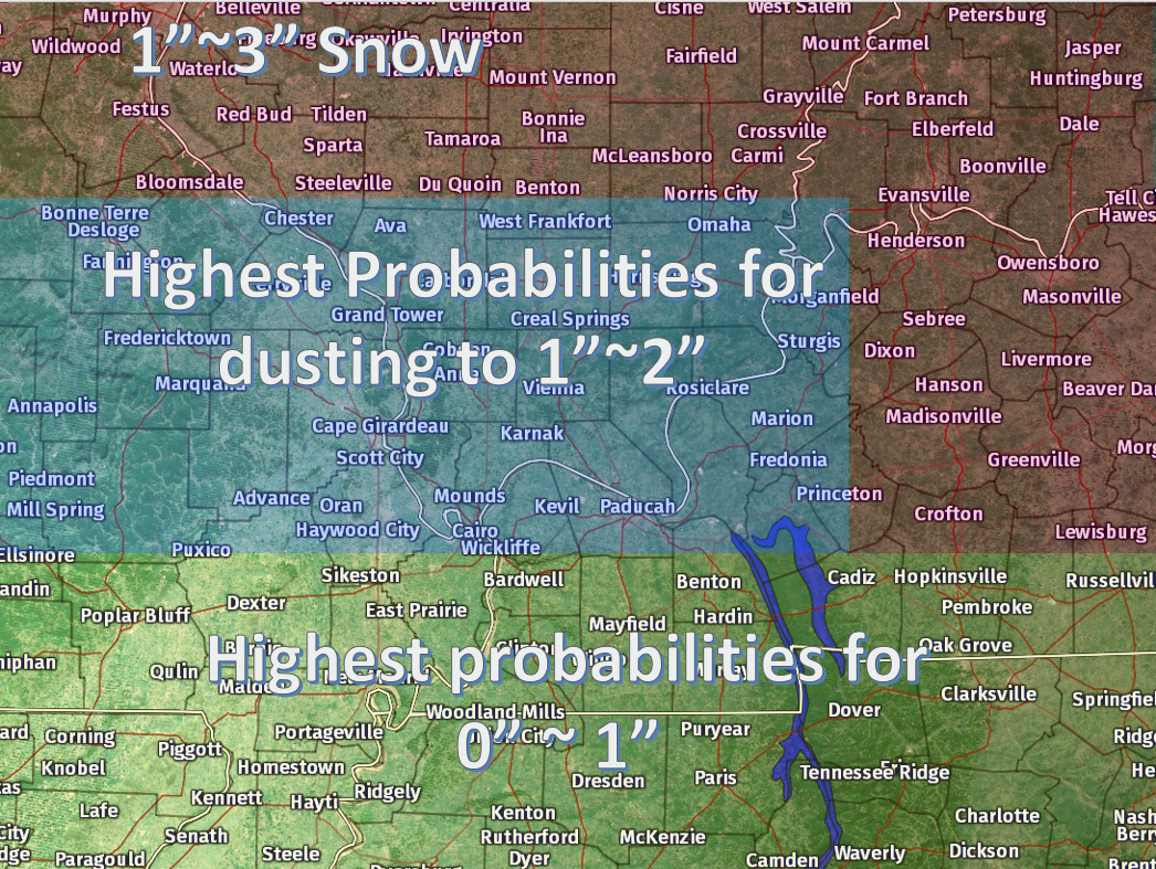
Red zone forecast
Blue zone
Yellow zone
My current forecast on this event
What could go wrong?
- Higher ratios. Meaning greater than 20:1. If 0.10″ of liquid falls in the form of snowflakes then that normally means 1″ of snow. When you have 20:1 ratios it means 2″ of snow. There is a possibility the system produces more snow than anticipated.
- Dry air eats the snow. If you have dry air at the surface then the snow evaporates before hitting the ground. This cuts into your snow totals. Sometimes radar shows snow over your house, but nothing is falling from the sky. This is because of dry air aloft. Until the atmosphere moistens up enough for the flakes to reach the ground they evaporate. Each flake that falls adds a little more moisture to the air. Eventually, if the storm has not moved out of the area, the snow will reach the ground.
- The system shifts slightly further south or north. Then the snow maps would need to be adjusted.
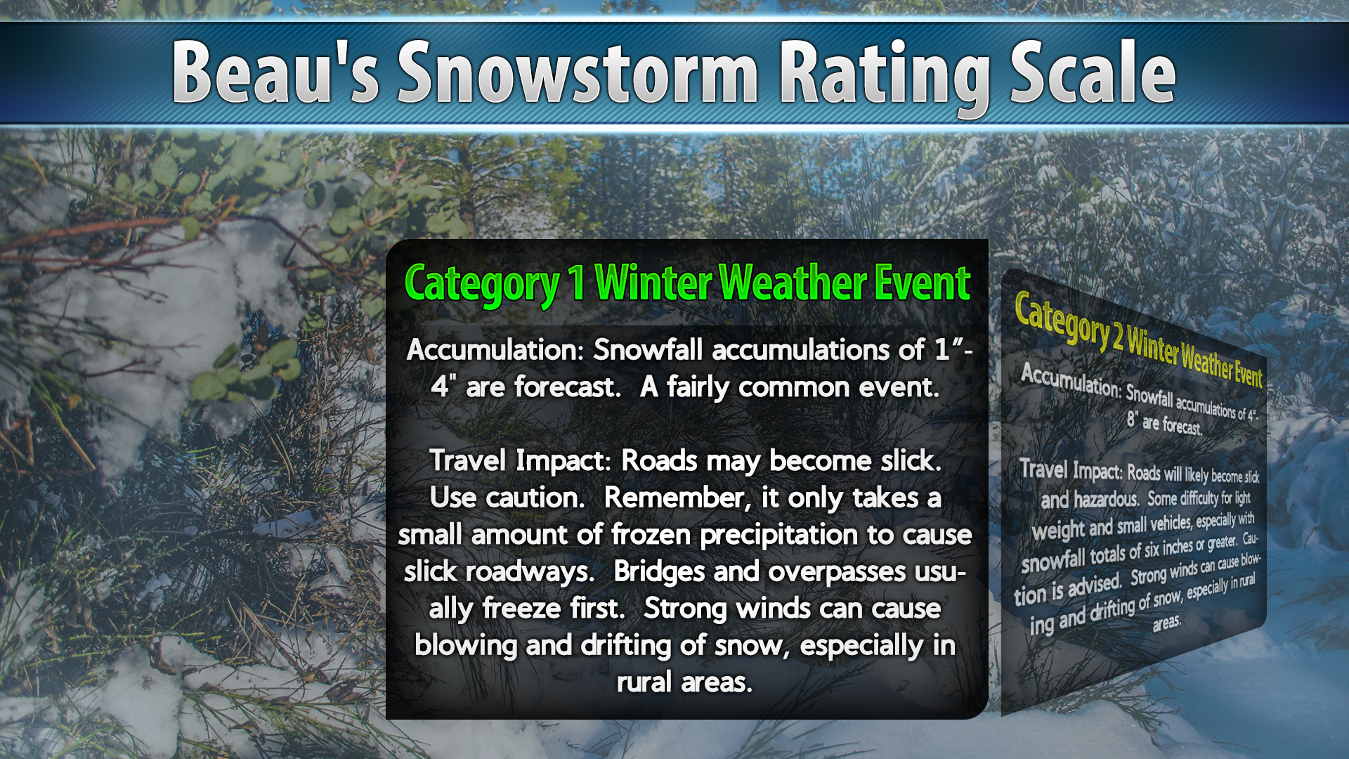
On the Beau Dodson Winter Storm Index this would be a small event, as well.
This is a borderline event (at this point). I will update everything again on Wednesday.
The late Wednesday night and Thursday system trended a little bit north over the past 24 hours.
This is not an easy forecast because of the dry air at the surface and how weak the system is. The forecast is a bit more complicated because of the ratios, as well.
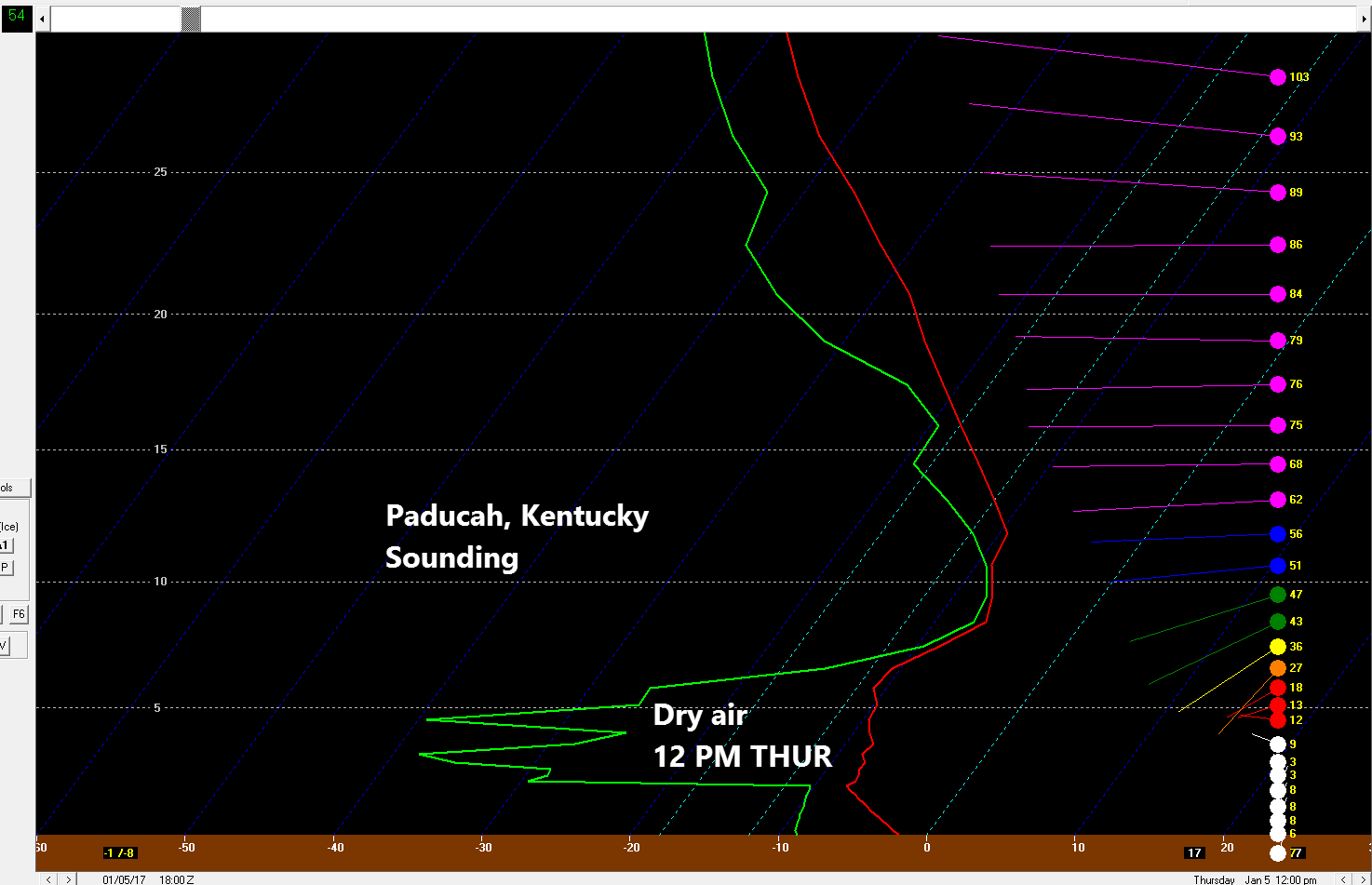
Let me show you a sounding. What is a sounding? A sounding is a slice of the atmosphere at a given time.
For example
This is the Paducah, Kentucky sounding for 12 pm on Thursday. The green line represents moisture and the red line is the temperature.
You are looking from the ground level up to 30,000′. The white line is the freezing line. Notice how the green and red lines are left of the white line? That means the entire atmosphere is below freezing. If precipitation falls then it would be snow.
Notice the dry air. The green line needs to hug the red line for the atmosphere to be fully moistened. That is when precipitation typically reaches the ground.
Quite a bit of dry air to overcome on this sounding. It would eat most of the snowflakes. Eat meaning they would evaporate.
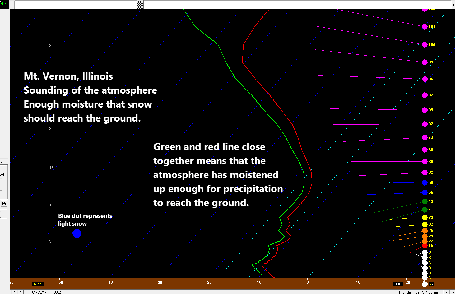
But, let’s look at Mt Vernon, Illinois for the Thursday snow potential. Notice how the green line and red line are touching? That means the atmosphere is allowing precipitation to reach the ground.
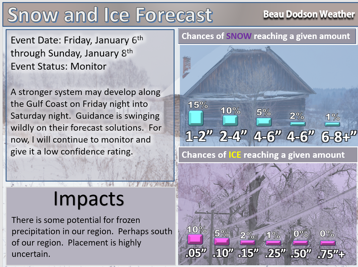
Friday, January 7th through Saturday night, January 8th
Concern: A system develops across portions of the Gulf of Mexico states. Model guidance has been all over the place with this event. The guidance won’t have a better handle on the set-up until the system into the West Coast. At that point, the models can sample the system.
Impact? Hazardous driving conditions if snow or a wintry mix develops.
Confidence: Low confidence that snow or a wintry mix will develop in or near our region. This system is a southern system. It may go so far south that our region misses out on precipitation. Stay tuned.
Confidence level on a scale from 1 to 10. One being the lowest confidence level. Ten being the highest confidence level.
Confidence level on accumulating snow or wintry mix across at least some portion of our area: 2
Milk and Cookies with Beau event? Unlikely, but monitor.
WPC/NOAA has issued a forecast on the snow potential.
Their map has changed a few times over the past two days. They did have a higher risk zone further to the west. They will be monitoring trends, as well.
This map will likely change over the next 72 hours. Let’s continue to monitor the track of the area of low pressure.
This is for the Friday/Saturday time frame. What is the probability of two inches of snow falling in that 24 hour period. Friday 6 pm until Saturday 6 pm.
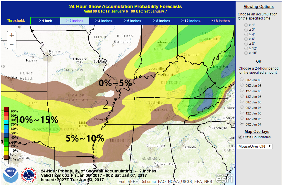
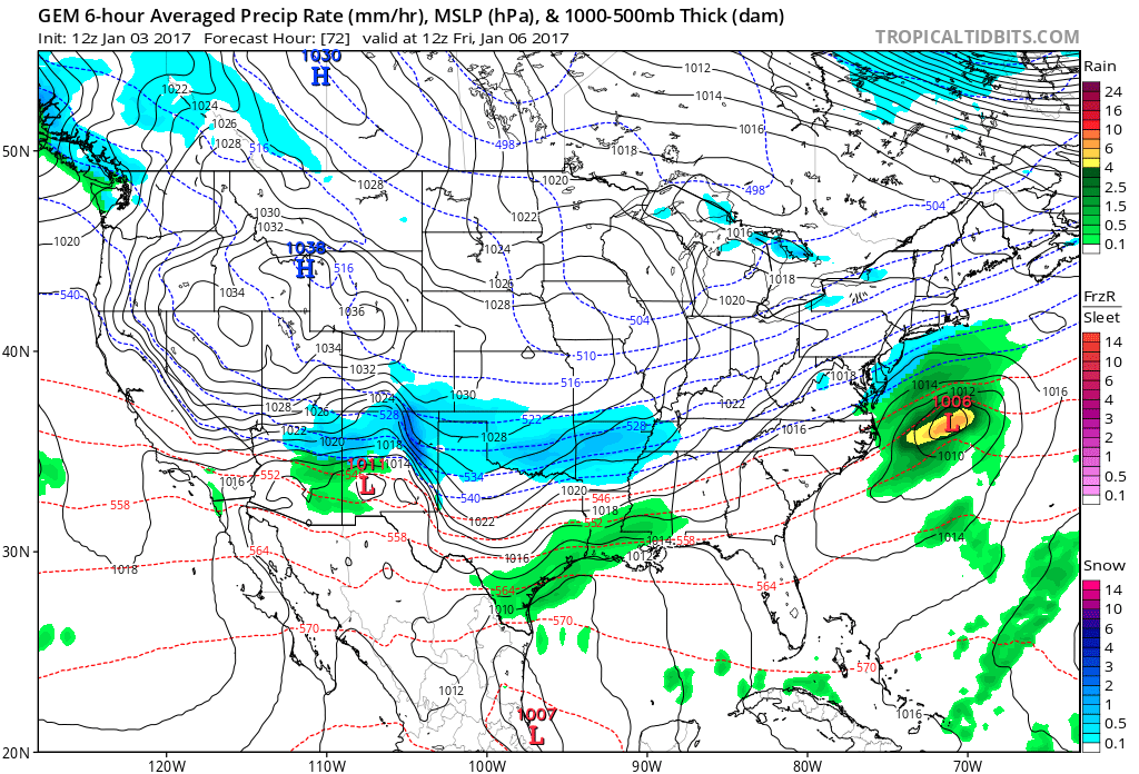
Let me show you the model differences on that system.
The Canadian GEM model is further north with the precipitation and a deeper area of low pressure. If the GEM is correct then portions of our region would recent measurable snow. It is the outlier, at this point.
Blue represents snow. Green represents rain.
This first map is for Friday at 6 am. You can see an area of snow near our region. Again, the GEM is the outlier.
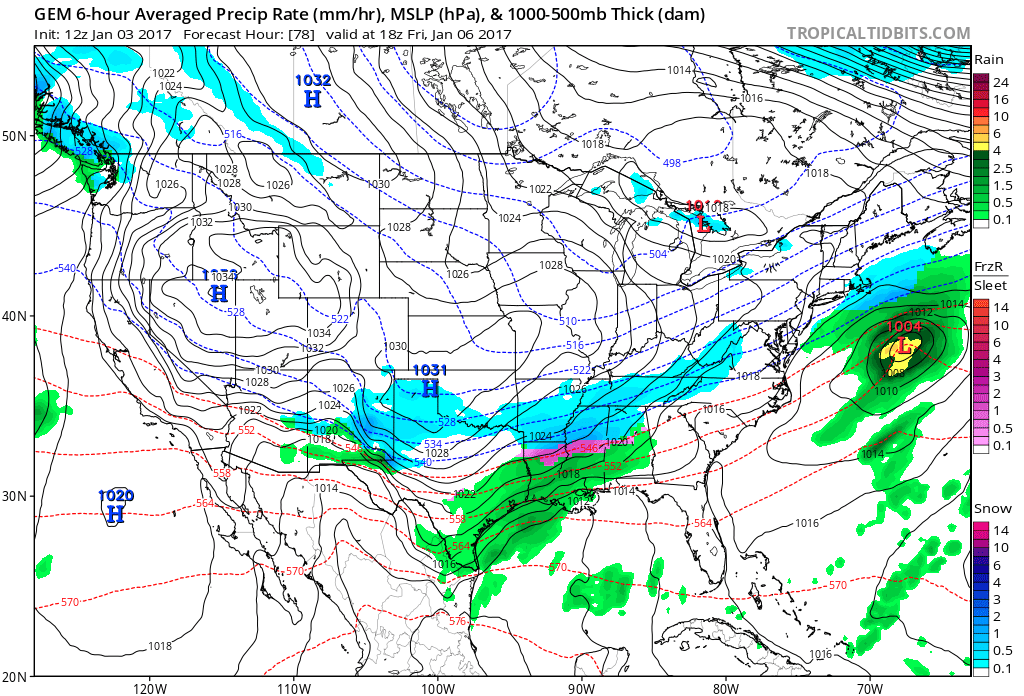
This next graphic is for Friday at 12 pm
Snow for western Tennessee on this map. Areas north remain dry.
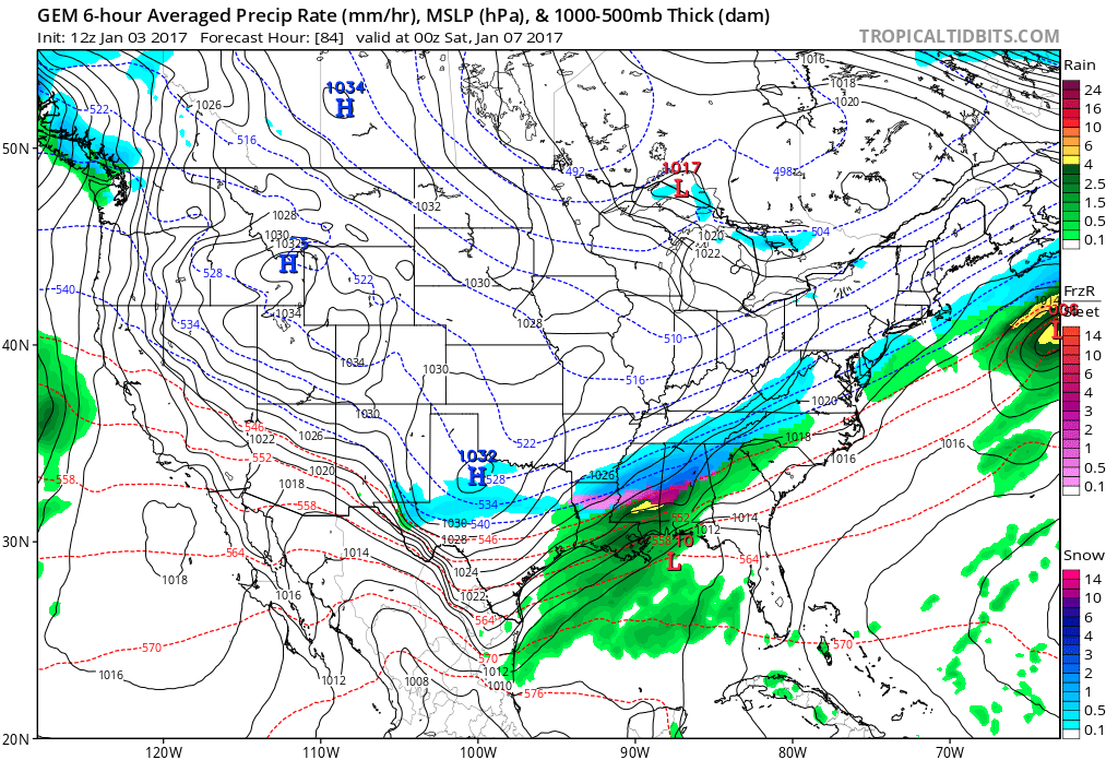
This next map is for Friday at 6 pm
Snow in Louisiana? GEM would say, yes.
Let’s look at the GFS. The GFS is so far south that we might not even see much in the way of clouds.
The GFS has snow and ice into central Mississippi.
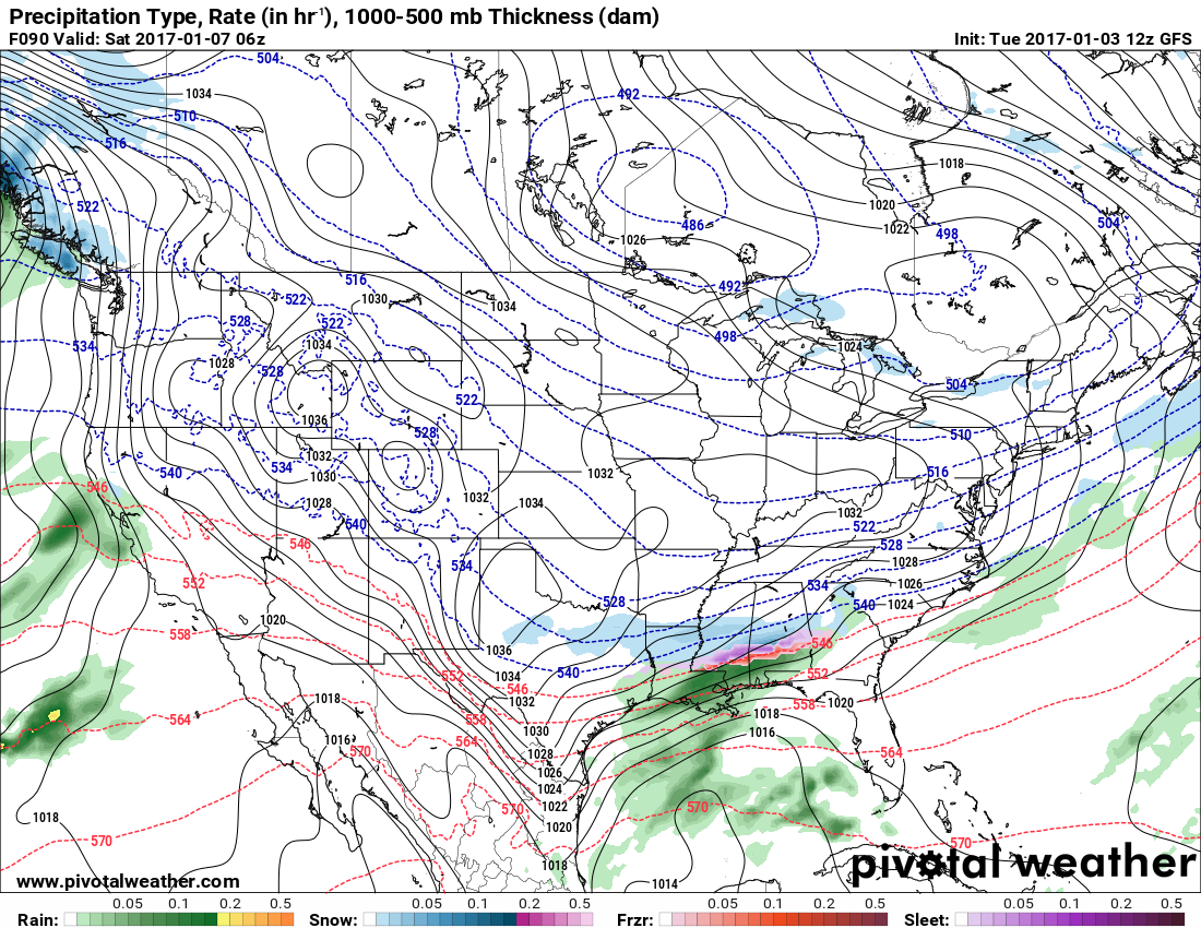
Folks, if you want snow from the Friday/Saturday system then you have to hope for a stronger area of lower pressure and a slight northwest trend. That is the only hope for snow.
Models typically are too far south with storm systems in this range of time. If the GEM is correct then we should closely monitor the system.
The EC is south, as well. Most of the models are south. It is a long shot, at this point.
I will update on this event on Wednesday. Still several days to monitor.
Don’t focus on specifics when it comes to the long range outlooks!
What is important is always the pattern when it comes to long range forecasting. There is not a meteorologist in the country that can accurately predict detailed snow forecasts weeks in advance. Not going to happen.
What we can do is show you the overall pattern. That gives us a general idea of what might happen.
The pattern, later this week, favors some precipitation somewhere from our region to the Gulf of Mexico. Placement is uncertain.
Forecasters who promise you snow three, four, five, six, seven days in advance often find themselves in this position…
What is the general idea?
1. Warming trend next week.
2. precipitation eventy around the 10th/11th. Should be rain.
3. Another system around the 15th through 17th
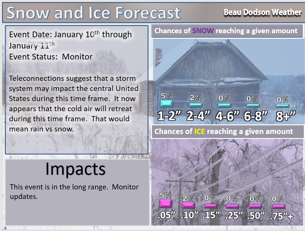
Tuesday, January 10th through Wednesday, January 11th
Concern: Precipitation event. Appears this will be a rain event.
Impact? Wet roadways.
Confidence: Very low on frozen precipitation occurring.
Confidence level on a scale from 1 to 10. One being the lowest confidence level. Ten being the highest confidence level.
Confidence level: 1
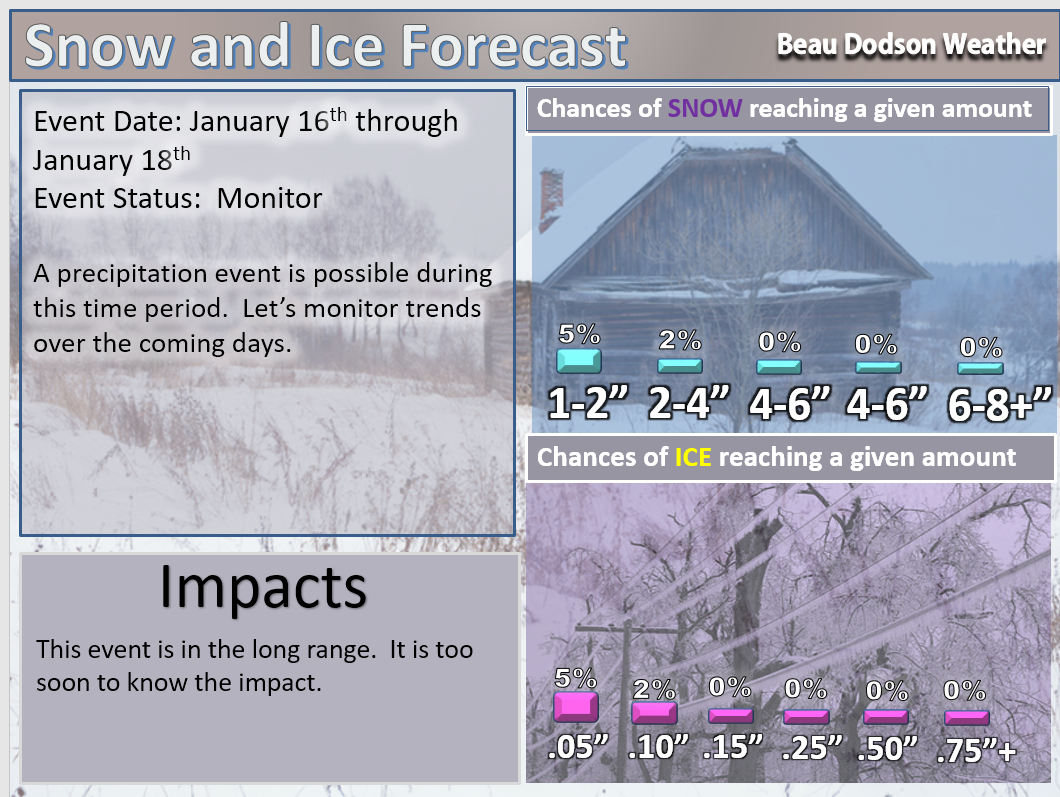
Monday, January 16th through Monday, January 18th
Concern: Precipitation event.
Impact? Unknown
Confidence: Very low
Confidence level on a scale from 1 to 10. One being the lowest confidence level. Ten being the highest confidence level.
Confidence level: 1
.
January 3rd through January 8th
Winter weather disclaimer.
This is a long range forecast. That means confidence is low as to the eventual outcome. Keep that in mind. Meteorologists have a hard enough time forecasting snow 24 hours in advance let alone days or weeks in advance.
If you want to read my philosophy, on long range forecasting, then I will point you to this article – Click Here
Long range forecasting is a little bit of skill and a lot of luck. The skill level dramatically decreases once we move past week one.
This next paragraph is Meteorologist John Dee’s comments on long range forecast. I agree with him.
I would like to start out by trying to differentiate between seasonal forecasting and weather forecasting for the next week or so.All weather forecasting involves a percentage of guessing. A forecast for the next 24-48 hours might be 90% science and 10% guesswork, and by the time you are trying to forecast for days 7, 8, 9 and 10, the percentages might be more like 50% science and 50% guesswork. By the time you get into seasonal forecasting, there is little proven science and methodology behind those forecasts- at least methods that truly work. Most seasonal forecasts are really just creative writing using meteorological terms! End of his comments.
End of his comments.
Winter is defined as December through February.
How do weather app’s know the forecast for anywhere in the world? Why does my weather app say heavy snow in two weeks?
These are questions that I receive on a regular basis. It is important to remember the weather app’s (for the most part) are computer-generated forecasts. There are a few app’s that allow tv stations to edit the forecast. Most, however, do not.
Why not to trust your cell phone app’s weather forecast.
App’s are, for the most part, not human based forecasts. They are simply spitting out what one computer model says. This is why the forecast on your app changes every few hours. Do not trust app’s. I call them cr’apps.
The link to the daily (free blog) is this talk.weathertalk.com
You can also check my Twitter feed (@beaudodson) and the Beau Dodson Weather Facebook page.
Remember, models are not forecasters. Models are nothing more than a set of algorithms/numbers turned into a pretty map. There is no interpretation by a human. They are for guidance only. People who post these maps are not issuing a forecast. They are just showing you the most extreme snowfall map they can find. Some of us in the weather business call this click bait.
What is click bait? It is showing people incredible snowfall maps with outrageous headlines. This happens in the spring, as well. In the spring it is normally a headline that reads BIG TORNADO OUTBREAK FORECAST. Then the details show the system is 5, 6, 7 or more days away. This serves only to scare people or upset them.
My advice, don’t share those posts or pages. Check with your trusted weather sources. See what they are saying. Your trusted weather sources are always going to be monitoring the situation. A forecast should ramp up and not down.
What does ramp up and not down mean? It means you don’t tell people that 8″ of snow will occur seven days down the road. You start out by mentioned a possible system down the road, but the details are not specific and it is too early for an accurate forecast. As time progresses, the confidence in what will happen will grow. It is at that time that you start to ramp up the rhetoric.
Occasionally the snow maps are correct, but most of the time they are not.
Snow can not be accurately forecast days in advance (with any confidence). Meteorologists do well to forecast snow accumulations within the 24 hour mark. I have witnessed snow forecasts bust WHILE it is snowing. What does bust mean? It means the forecast busted/did not verify.
Definitions:
Analogs: Analog forecasting is based on looking at previous years and trying to find a similar match to current conditions. This can help forecasters determine probabilities of X, Y, and Z happening. Weather repeats itself. Finding the match is what is difficult.
Arctic Outbreak: Bitterly cold air that moves from the arctic into Canada and then into the United States. These cold outbreaks are responsible for temperatures below zero to lower teens in our region.
Clipper: An Alberta clipper (also known as a Canadian Clipper) is a fast moving low pressure area which generally affects the central provinces of Canada and parts of the Upper Midwest and Great Lakes regions of the United States, precipitating a sudden temperature drop and sharp winds.
Ensembles: See below for a longer explanation. Ensembles are models that are run multiple times with slightly different variables. The more agreement among the ensemble guidance the higher the confidence in the eventual outcome of weather conditions.
GFS: An American model. Medium to high skill model.
GEM: A Canadian model. Medium skill model.
NAM & WRF: An American short range model. High skill level.
EC: A European model. High skill model.
CFS-2: An American model array used for long range forecasting. Low to medium skill model.
Guidance: Another word for models.
Isobars: Equal lines of pressure. Tightly packed isobars typically mean windier conditions.
Low pressure: Typically associated with rain or snow. Unsettled weather.
Canadian High Pressure: Typically associated with cold to bitter cold temperatures.
Models: Models are what forecasters use for guidance when issuing a forecast. Models alone do not forecast the weather. They offer guidance when making forecast decisions.
Pattern: The general weather conditions in the long range.
Trends: What direction is the guidance moving. Warmer? Colder? Track of the low further north of south?
Short range: One to three days into the future.
Medium range: Four to six days into the future.
Long range: More than six days into the future.
What are ensembles?
There are two types of models. There is what we call the control/operational run and there are ensembles. Ensembles give you a spread. They show you different possible solutions. The more ensemble members agree the better the chance the forecast will verify.
For example, let’s say I run the GFS model ten times. Each time with slightly different variables. Once finished, eight of the ten model runs show rain next Wednesday. That means you have a higher than normal confidence in the eventual outcome of the weather conditions. It does not mean the model will always be correct. It just adds to the confidence level.
The EC model is for Medium-term Weather Prediction, the operational model is re-run at a lower resolution (than the control run) and this is then repeated 50 times, each with slightly different starting conditions.
Don’t focus on specifics when it comes to the long range outlooks!
NOT specifics. What is important is always going to be the pattern when it comes to long range forecasting. There is not a meteorologist in the country that can accurately predict detailed forecasts weeks in advance. Not going to happen.
What we can do is show you the overall pattern. That gives us a general idea of what might happen.
Remember, it is not uncommon to have wild fluctuations in what the models show past week one. In other words, these maps can change from run to run. Most computer models are updated four times each day.
.
Here is the official 6-10 day and 8-14 day temperature and precipitation outlook. Check the date stamp at the top of each image (so you understand the time frame).
The forecast maps below are issued by the Weather Prediction Center (NOAA).


The latest 8-14 day temperature and precipitation outlook. Note the dates are at the top of the image. These maps DO NOT tell you how high or low temperatures or precipitation will be. They simply give you the probability as to whether temperatures or precipitation will be above or below normal.


Have you switched phone carriers?
If you have recently switched phone carriers then be sure and adjust your Weather Talk account settings. Just click on the My Personal Notification Settings tab. You will then see the pull down menu with different phone carriers. Choose the one that best fits your phone (ATT, Verizon, and so on).
Updated PayPal or credit cards.
Don’t forget to update your credit card information if you have a new card. You can do that by clicking on the My Account tab and then click the second green button. The same applies to PayPal.
Your support helps cover costs. Each month I have at or more than $700 in expenses. That is my out of pocket expenses. Don’t forget the proceeds also help with the Shadow Angel Foundation projects. You can view those projects at this link – Click Here.

Invite Your Friends!
Be sure and invite your friends to sign up for the Weather Talk text messages. Remember, there are four text messages you can choose from.
You can adjust your account settings whenever you like.
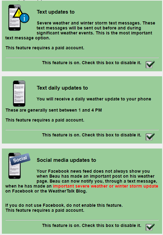
The first text message option is the most important one. The severe weather text messages. I send these out during severe thunderstorms, tornadoes, and winter storms.
The second text message option is the daily weather forecast. Typically this is updated between 12 pm and 4 pm each day. You will receive the forecast for tonight and tomorrow. They will arrive as two messages. This is because of limits on how many characters can be sent in a text. I am also hand typing them.
The third text message option is the social media texts for severe weather/winter storm days. I will send you the latest link to videos, the blog, and the Facebook threads.
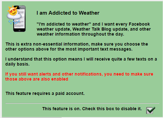
The fourth text option (does NOT replace any of the other three) is for non-severe weather day social media links. I will send you a link to the latest video, blog update, Facebook thread, and winter storm outlooks. Again, this text option does NOT replace the other three. You still need to select the other three (or whichever ones you wish to receive).
Here is what the four text message options look like on the Weather Talk website (under the My Personal Notification Settings tab).
and the fourth one (which does not replace the other three)