Monthly costs to run Weather Talk can top $2000.00
Please consider subscribing!
Here are my monthly out of pocket costs to deliver you the weather.
.

.
Do you want more? How about short and long range outlooks, videos, and more detailed analysis! You will receive that with your subscription.
Subscribe at www.beaudodsonweather.com
Once subscribed you can choose from four different app/text messages!
.
.
Subscriber videos and long range update – Click Here
.

.
January 29, 2018
Monday Forecast Details
Forecast: Gusty winds at times. Cloudy. A chance of flurries or snow showers before 2 pm. Ending from northwest to southeast. Some areas will likely not see any precipitation. No accumulation to perhaps a spotty dusting.
Temperatures: MO ~ 34 to 38 IL ~ 34 to 38 KY ~ 34 to 38
What is the chance of precipitation? MO ~ 20% IL ~ 30% KY ~ 40% TN ~ 10%
Coverage of precipitation: Isolated to spotty possible
Wind chill values: 20 to 34
Accumulating snow or ice: Small chance of a dusting in a few spots.
Winds: North at 5 to 10 mph with gusts to 30 mph
What impacts are anticipated from the weather? Most likely none, but monitor updates.
My confidence in the forecast verifying: Medium
Is severe weather expected? No
The NWS defines severe weather as 58 mph wind or great, 1″ hail or larger, and/or tornadoes
Should I cancel my outdoor plans? No
.
Monday Night Forecast Details:
Forecast: Evening clouds departing. Becoming mostly clear. Cold.
Temperatures: MO ~ 16 to 24 IL ~ 14 to 20 KY ~ 16 to 24
What is the chance of precipitation? MO ~ 0% IL ~ 0% KY ~ 0% TN ~ 0%
Coverage of precipitation: None
Wind chill values: 10 to 20
Accumulating snow or ice: No
Winds: North at 10 to 20 mph early becoming north at 6 to 12 mph
What impacts are anticipated from the weather? None
My confidence in the forecast verifying: High
Is severe weather expected? No
The NWS defines severe weather as 58 mph wind or great, 1″ hail or larger, and/or tornadoes
Should I cancel my outdoor plans: No
.
January 30, 2018
Tuesday Forecast Details
Forecast: Mostly sunny. Chilly. Some passing clouds through the day.
Temperatures: MO ~ 36 to 42 IL ~ 35 to 40 KY ~ 35 to 40
What is the chance of precipitation? MO ~ 0% IL ~ 0% KY ~ 0% TN ~ 0%
Coverage of precipitation: None
Wind chill values: 28 to 35
Accumulating snow or ice: No
Winds: North becoming south at 6 to 12 mph
What impacts are anticipated from the weather? None
My confidence in the forecast verifying: High
Is severe weather expected? No
The NWS defines severe weather as 58 mph wind or great, 1″ hail or larger, and/or tornadoes
Should I cancel my outdoor plans? No
.
Tuesday Night Forecast Details:
Forecast: Mostly clear. Cold. Breezy, at times.
Temperatures: MO ~ 26 to 32 IL ~ 26 to 32 KY ~ 28 to 32
What is the chance of precipitation? MO ~ 0% IL ~ 0% KY ~ 0% TN ~ 0%
Coverage of precipitation: None
Wind chill values: 20 to 30
Accumulating snow or ice: No
Winds: South at 5 to 10 mph becoming gusty overnight.
What impacts are anticipated from the weather? None
My confidence in the forecast verifying: High
Is severe weather expected? No
The NWS defines severe weather as 58 mph wind or great, 1″ hail or larger, and/or tornadoes
Should I cancel my outdoor plans: No
.
January 31, 2018
Wednesday Forecast Details
Forecast: Becoming windy. Mostly sunny during the morning. Some increase in clouds during the afternoon. Mild.
Temperatures: MO ~ 52 to 56 IL ~ 52 to 56 KY ~ 52 to 56
What is the chance of precipitation? MO ~ 0% IL ~ 0% KY ~ 0% TN ~ 0%
Coverage of precipitation: None
Wind chill values: N/A
Accumulating snow or ice: No
Winds: South at 7 to 14 mph with gusts to 30 mph during the afternoon
What impacts are anticipated from the weather? None
My confidence in the forecast verifying: High
Is severe weather expected? No
The NWS defines severe weather as 58 mph wind or great, 1″ hail or larger, and/or tornadoes
Should I cancel my outdoor plans? No
.
Wednesday Night Forecast Details:
Forecast: Becoming cloudy. A chance of mainly late night rain showers. Cool.
Temperatures: MO ~ 36 to 44 IL ~ 36 to 44 KY ~ 36 to 44
What is the chance of precipitation? MO ~ 40% IL ~ 40% KY ~ 40% TN ~ 30%
Coverage of precipitation: Scattered
Wind chill values: 30 to 40
Accumulating snow or ice: No
Winds: South becoming southwest at 6 to 12 mph
What impacts are anticipated from the weather? Wet roadways
My confidence in the forecast verifying: High
Is severe weather expected? No
The NWS defines severe weather as 58 mph wind or great, 1″ hail or larger, and/or tornadoes
Should I cancel my outdoor plans: No
.
The Thursday through Monday part of the forecast remains in the LOW confidence category. Monitor updates.
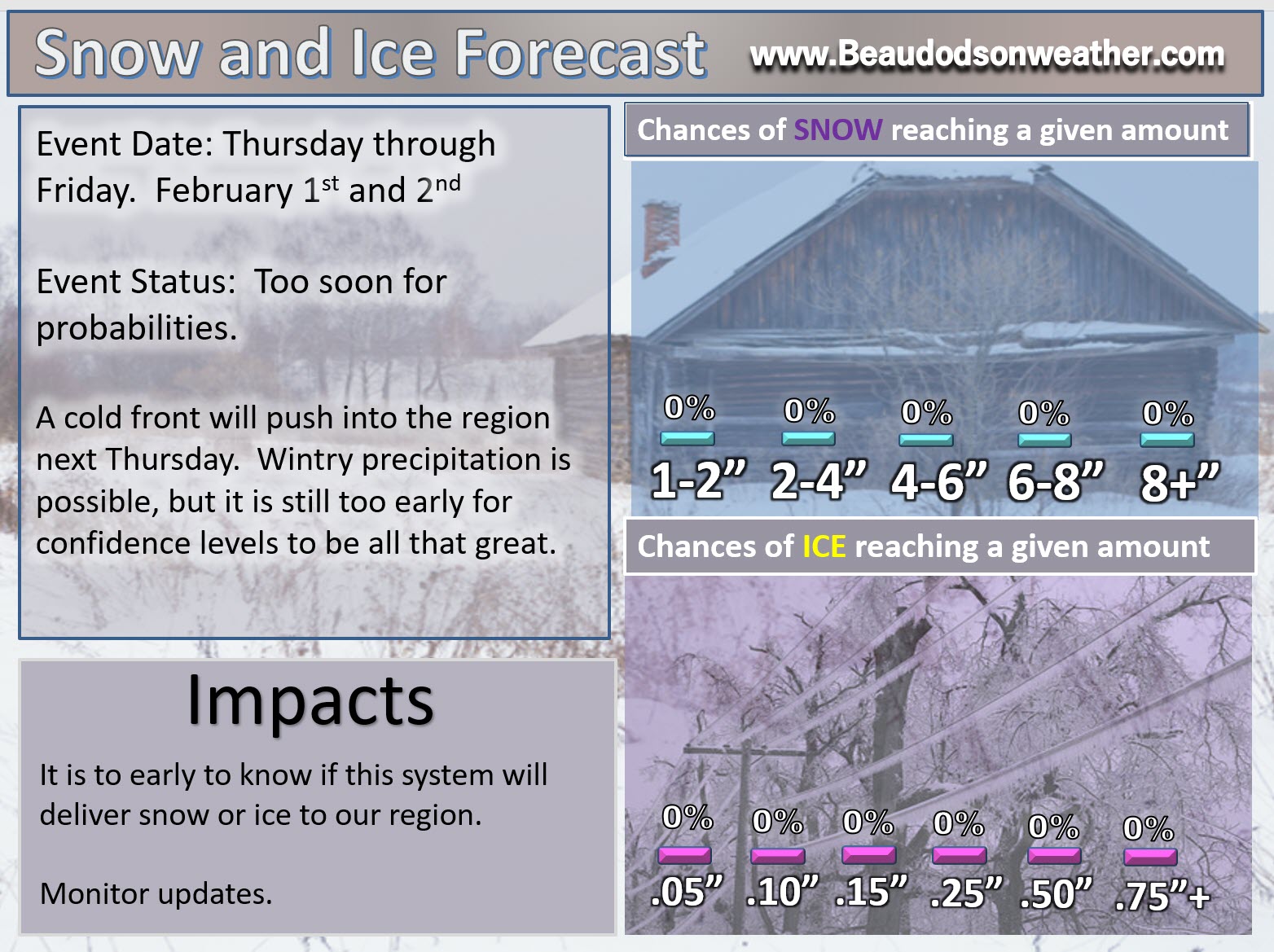
February 1, 2018
Thursday Forecast Details
Forecast: Mostly cloudy. Rain showers likely. Colder air may move into the area late in the day. I will be monitoring that portion of the forecast. If the cold air moves in fast enough then rain showers may change to snow showers. Low confidence.
Temperatures: MO ~ 34 to 44 Temps may fall during the day IL ~ 34 to 44 temps may fall during the day KY ~ 42 to 48
What is the chance of precipitation? MO ~ 60% IL ~ 60% KY ~ 60% TN ~ 60%
Coverage of precipitation: Scattered to perhaps widespread.
Wind chill values: 20 to 32
Accumulating snow or ice: Monitor updates.
Winds: West at 8 to 16 mph and gusty. Winds becoming north and northwest behind the cold front (northern portions of the area).
What impacts are anticipated from the weather? Wet roadways. Monitor updates.
My confidence in the forecast verifying: Medium
Is severe weather expected? No
The NWS defines severe weather as 58 mph wind or great, 1″ hail or larger, and/or tornadoes
Should I cancel my outdoor plans? Have a plan B
.
Thursday Night Forecast Details:
Forecast: Cloudy early. Snow showers possible. Clearing and colder overnight.
Temperatures: MO ~ 18 to 25 IL ~ 18 to 24 KY ~ 24 to 28
What is the chance of precipitation? MO ~ 30% IL ~ 30% KY ~ 30% TN ~ 30%
Coverage of precipitation: Scattered early.
Wind chill values: 10 to 18
Accumulating snow or ice: Possible, but confidence remains low.
Winds: Becoming north and northwest at 10 to 20 mph
What impacts are anticipated from the weather? Monitor updates
My confidence in the forecast verifying: LOW
Is severe weather expected? No
The NWS defines severe weather as 58 mph wind or great, 1″ hail or larger, and/or tornadoes
Should I cancel my outdoor plans: Have a plan B and monitor updates
.
February 2, 2018
Friday Forecast Details
Forecast: Partly cloudy. Colder.
Temperatures: MO ~ 30 to 35 IL ~ 30 to 35 KY ~ 30 to 35
What is the chance of precipitation? MO ~ 10% IL ~ 10% KY ~ 10% TN ~ 10%
Coverage of precipitation: Most likely none
Wind chill values: 20 to 30
Accumulating snow or ice: No
Winds: North and northwest at 5 to 10 mph
What impacts are anticipated from the weather? None
My confidence in the forecast verifying: Medium
Is severe weather expected? No
The NWS defines severe weather as 58 mph wind or great, 1″ hail or larger, and/or tornadoes
Should I cancel my outdoor plans? No
.
Friday Night Forecast Details:
Forecast: Mostly clear. Colder
Temperatures: MO ~ 18 to 22 IL ~ 16 to 20 KY ~ 18 to 22
What is the chance of precipitation? MO ~ 0% IL ~ 0% KY ~ 0% TN ~ 0%
Coverage of precipitation: None
Wind chill values: 10 to 20
Accumulating snow or ice: No
Winds: South at 6 to 12 mph
What impacts are anticipated from the weather? Most likely none.
My confidence in the forecast verifying: High
Is severe weather expected? No
The NWS defines severe weather as 58 mph wind or great, 1″ hail or larger, and/or tornadoes
Should I cancel my outdoor plans: No
.
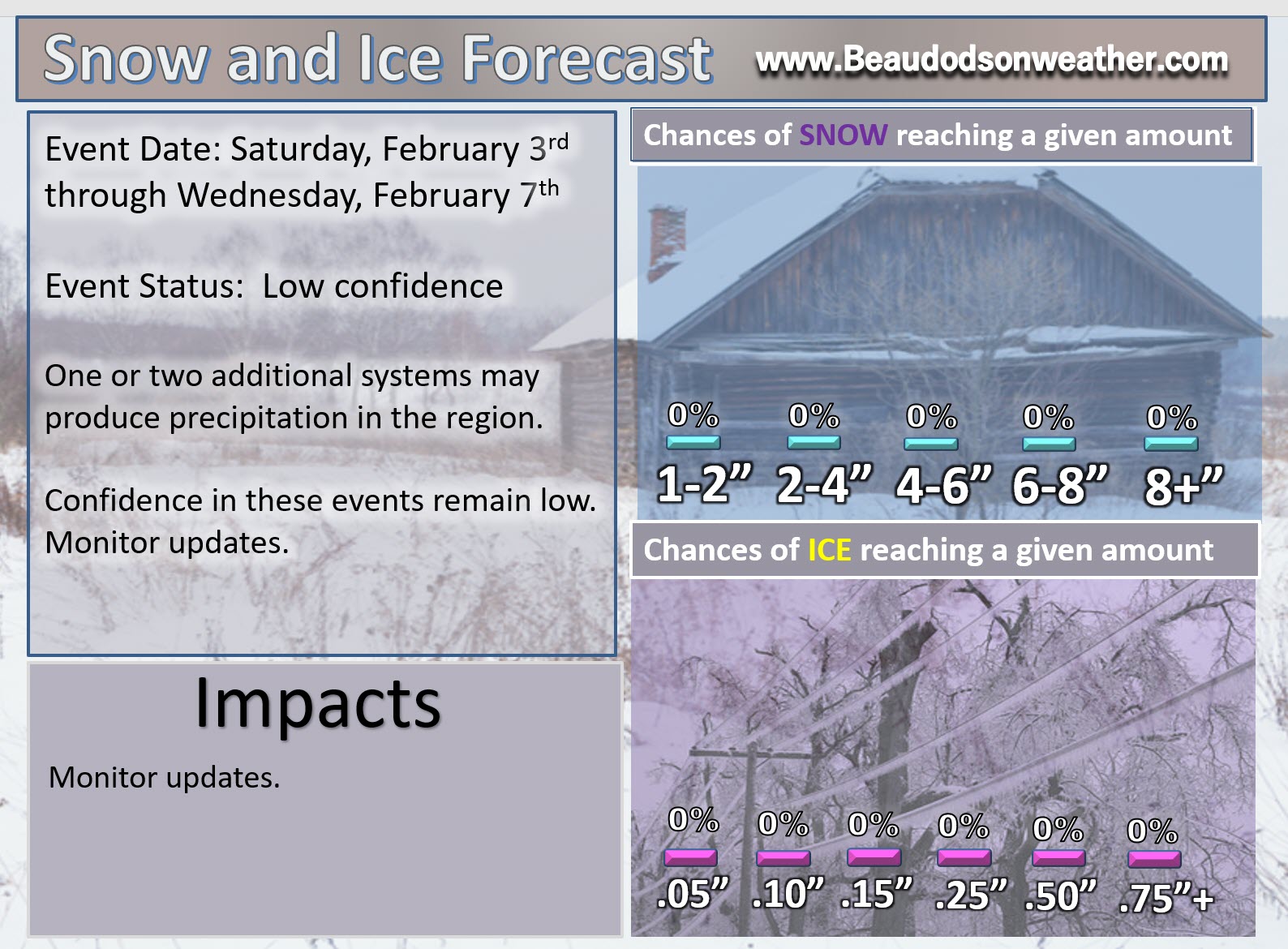
February 3, 2018
Saturday Forecast Details
Forecast: A mix of sun and clouds. Cool.
Temperatures: MO ~ 38 to 44 IL ~ 38 to 44 KY ~ 38 to 44
What is the chance of precipitation? MO ~ 10% IL ~ 10% KY ~ 10% TN ~ 10%
Coverage of precipitation: None
Wind chill values: 30 to 40
Accumulating snow or ice: No
Winds: South at 10 to 20 mph and gusty
What impacts are anticipated from the weather? None
My confidence in the forecast verifying: LOW
Is severe weather expected? No
The NWS defines severe weather as 58 mph wind or great, 1″ hail or larger, and/or tornadoes
Should I cancel my outdoor plans? No
.
Saturday Night Forecast Details:
Forecast: Increasing clouds. Snow showers possible.
Temperatures: MO ~ 28 to 34 IL ~ 28 to 34 KY ~ 28 to 34
What is the chance of precipitation? MO ~ 30% IL ~ 30% KY ~ 30% TN ~ 30%
Coverage of precipitation: Scattered
Wind chill values: 20 to 30
Accumulating snow or ice: Monitor updates
Winds: South 7 to 14 mph with gusts to 20 mph
What impacts are anticipated from the weather? Monitor updates
My confidence in the forecast verifying: LOW
Is severe weather expected? No
The NWS defines severe weather as 58 mph wind or great, 1″ hail or larger, and/or tornadoes
Should I cancel my outdoor plans: Monitor updates
.
February 4, 2018
Sunday Forecast Details
Forecast: Partly cloudy. Snow showers possible.
Temperatures: MO ~ 30 to 35 IL ~ 30 to 35 KY ~ 30 to 35
What is the chance of precipitation? MO ~ 30% IL ~ 30% KY ~ 30% TN ~ 30%
Coverage of precipitation: Scattered
Wind chill values: 20 to 30
Accumulating snow or ice: Monitor updates
Winds: North at 7 to 14 mph with gusts to 20 mph
What impacts are anticipated from the weather? Monitor updates
My confidence in the forecast verifying: LOW
Is severe weather expected? No
The NWS defines severe weather as 58 mph wind or great, 1″ hail or larger, and/or tornadoes
Should I cancel my outdoor plans? Monitor updates
.
Sunday Night Forecast Details:
Forecast: A chance for snow showers.
Temperatures: MO ~ 15 to 20 IL ~ 15 to 20 KY ~ 15 to 20
What is the chance of precipitation? MO ~ 30% IL ~ 30% KY ~ 30% TN ~ 30%
Coverage of precipitation: Scattered
Wind chill values: 8 to 16
Accumulating snow or ice: Monitor updates
Winds: North 7 to 14 mph with gusty winds possible
What impacts are anticipated from the weather? Monitor updates
My confidence in the forecast verifying: LOW
Is severe weather expected? No
The NWS defines severe weather as 58 mph wind or great, 1″ hail or larger, and/or tornadoes
Should I cancel my outdoor plans: Monitor updates
.
February 5, 2018
Monday Forecast Details
Forecast: Partly cloudy. Snow showers possible. Cold.
Temperatures: MO ~ 25 to 30 IL ~ 25 to 30 KY ~ 25 to 30
What is the chance of precipitation? MO ~ 20% IL ~ 20% KY ~ 20% TN ~ 20%
Coverage of precipitation:
Wind chill values: 15 to 25
Accumulating snow or ice: Monitor updates
Winds: North 6 to 12 mph
What impacts are anticipated from the weather? Monitor updates
My confidence in the forecast verifying: LOW
Is severe weather expected? No
The NWS defines severe weather as 58 mph wind or great, 1″ hail or larger, and/or tornadoes
Should I cancel my outdoor plans? Monitor updates
.
Monday Night Forecast Details:
Forecast: Mostly clear. Cold.
Temperatures: MO ~ 12 to 18 IL ~ 12 to 18 KY ~ 14 to 18
What is the chance of precipitation? MO ~ 0% IL ~ 0% KY ~ 0% TN ~ 0%
Coverage of precipitation: None
Wind chill values: 0 to 15
Accumulating snow or ice:
Winds: North 5 to 10 with gusts to 12 mph
What impacts are anticipated from the weather? Monitor updates
My confidence in the forecast verifying: Medium
Is severe weather expected? No
The NWS defines severe weather as 58 mph wind or great, 1″ hail or larger, and/or tornadoes
Should I cancel my outdoor plans: Monitor updates
.

.
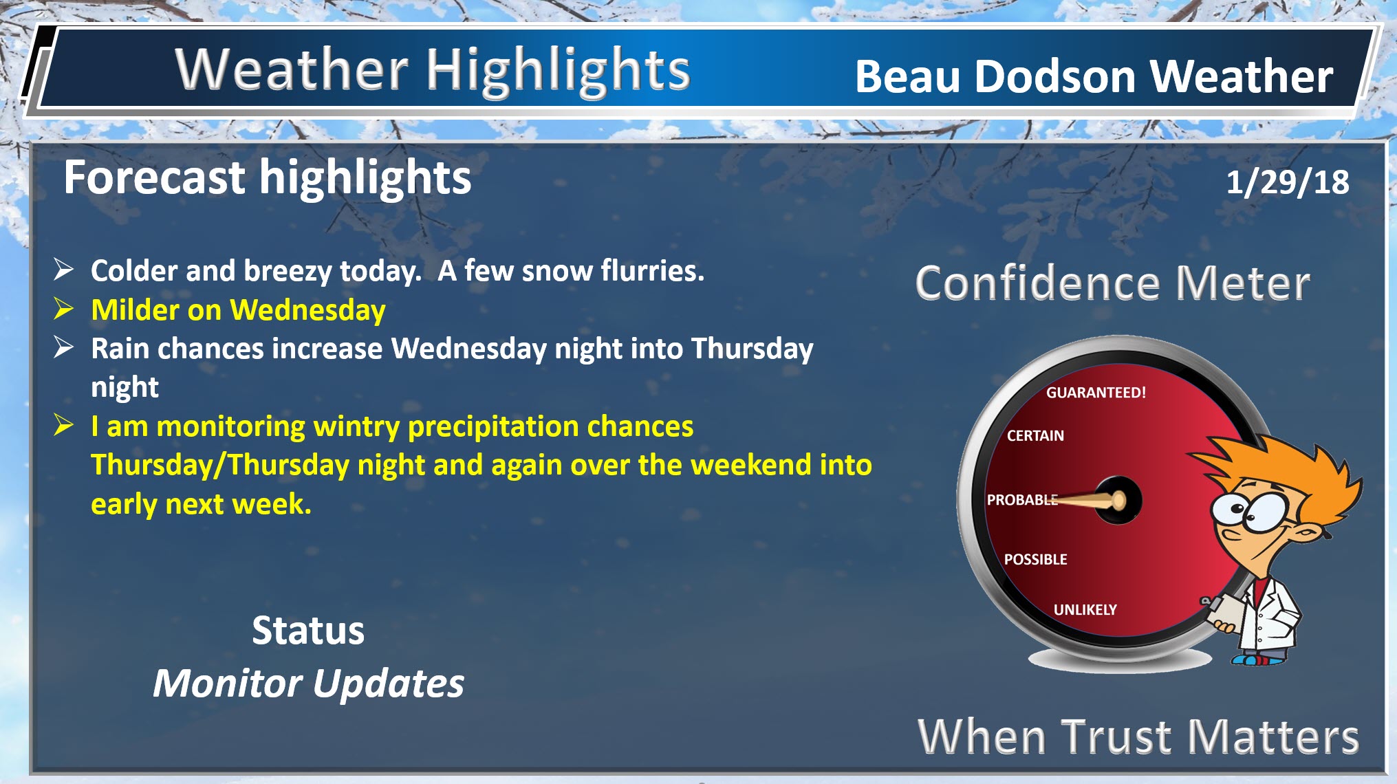
Monday through Wednesday afternoon: A few flurries possible today. Cold and windy with low wind chill values.
No snow or ice tonight (Monday night) through Wednesday night.
I am tracking the potential of snow Thursday into Friday. Confidence on accumulation remains low.
If you have travel plans Thursday into the weekend then you should monitor updated forecasts and have a plan B.
Another chance of snow arrives Saturday night into Sunday night. Another chance early next week. Unfortunately, both of those are too far out for any real confidence on the details. Monitor updates, as always. The pattern is active.
.

.
The National Weather Service definition of a severe thunderstorm is one that produces quarter size hail or larger, 58 mph winds or greater, and/or a tornado.
Now through next Wednesday: No severe weather concerns.
.

.
January 29, 2018
The daily outlook can be found at the bottom of this post.
Forecast
Interactive Weather Radar Page. Choose the city nearest your location: Click this link.
Short term outlook:
I want to answer a question that keeps popping up.
Why does your Weather Channel app (other) keep showing a different forecast every few hours. The reason for this is because those forecasts are produced from a computer. It is not a human forecast. When the model changes your Weather Channel app changes.
The vast majority of app forecasts are based off the GFS computer. When the GFS computer model changes, then your app forecast changes.
They are not human forecasts. No human adjusts your app forecast. That is why you can enter any zip code and come up with a forecast.
If the morning run of the GFS model shows heavy snow Sunday, then your app will show heavy snow Sunday. If the afternoon run of the GFS model shows sunny and 70 degrees on Sunday, then your app will show you the same. This is why the forecast on your app is always changing.
My app is different, of course. I am typing you my forecast and hitting send. Most apps, however, are not like that.
Forecast:
Cold weather will be with us today into tonight.
A cold front is passing through the region. Temperatures won’t rise much today. Plan on highs only in the 30’s. Well below the seasonal norms.
Clouds will make it feel colder, as well. Gusty winds in the 15 to 30 mph range will push wind chills down into the 18 to 28 degree range.
A few snow flurries are being reported in the area. Flurries or snow showers will be possible into early afternoon.
Clearing and cold tonight. Lows will range from 16 to 22 degrees.
Tuesday and Wednesday:
Dry weather is anticipated on Tuesday and Wednesday. A slow warming trend, as well.
Highs on Tuesday will top out in the upper 30’s to middle 40’s. Highs on Wednesday will top out in the 50’s. See the daily details at the bottom of this page.
Wednesday night into Friday:
As is typical during the winter months, the long range outlook is complicated.
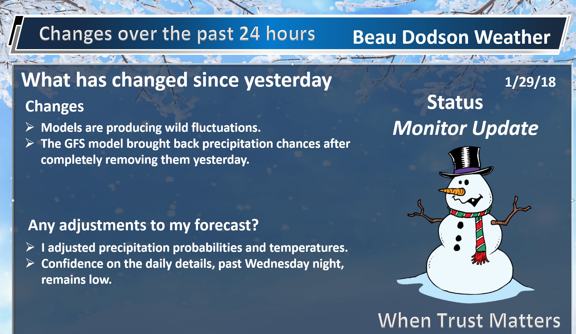
I have been giving a LOW confidence rating on the daily details.
Models have been of little use. They have shown wild swings. At times the GFS model will show 10″ of snow. At times the GFS model will show no snow, at all. Other models have been similar.
The only consistent model has been the Canadian. Even it has had some small swings.
The reason for these wild swings is that the storm system remains off the West Coast. It has not been sampled, yet. Sampled means the models don’t have all the information they need in order to produce accurate outcomes. This makes forecasting difficult.
A cold front will enter our region Wednesday night and Thursday. This front will produce a few showers ahead of it. The bulk of the precipitation, however, is forecast to fall behind the front. This would be in the colder air.
How much moisture remains behind the front is highly questionable.
I continue to feel confident that we will have precipitation falling from the sky late Wednesday night into perhaps Thursday night or Friday. I feel confident that rain will occur. What I am not confident about is the snow portion of the forecast.
I have snow in the forecast, but how much snow accumulation, if any, is the bigger question.
I do not change my forecast with every model run. That is actually not forecasting that is model-casting. Thus far, my forecast has remained fairly steady concerning the Thursday/Friday time frame. You will see me making larger adjustments once confidence in the eventual forecast becomes clearer.
There are two many variables for certainty. Whether an area of low pressure develops along the front will be key to the potential of a winter storm in or near our region.
I have been telling people that we may not have a complete handle on the forecast until Tuesday night and Wednesday. That thought remains unchanged.
I will continue to monitor trends in the guidance.
To complicate the forecast further, a second cold front is possible over the weekend. This front could also produce precipitation. Confidence is low on the the eventual outcome of that front, as well.
Best advice, monitor updated forecasts.
This is an active pattern. There will be several precipitation chances over the next 14 days. There will also be quite a bit of cold air available. There is an above normal chance for wintry precipitation in February.
Remember, potential does not always make reality. It takes all of the weather ingredients coming together, just right, in order for our region to have a winter weather event.
.
.

.
.
.


We offer regional radars and local city radars – if a radar does not update then try another one. Occasional browsers need their cache cleared. You may also try restarting your browser. This will usually fix any problems.
During the winter you can track snow and ice by clicking the winterize button on the local city view interactive radars.
You may email me at beaudodson@usawx.com
Interactive Weather Radar Page. Choose the city nearest your location: Click this link
National interactive radar: Click this link.