We have our first sponsor for the blog. Milner and Orr Funeral Home and Cremation Services located in Paducah, Kentucky and three other western Kentucky towns – at Milner and Orr they believe in families helping families.
![]()

This forecast update covers far southern Illinois, far southeast Missouri, and far western Kentucky. See the coverage map on the right side of the blog.
Remember that weather evolves. Check back frequently for updates, especially during active weather.
Wednesday – Periods of mostly sunny sky conditions. Possibly some partly cloudy sky conditions from time to time. We will be in between weather systems. Highs will once again be in the 40’s. Southeast winds at 5-10 mph with gusts to 15 mph.
Morning School Bus Stop Weather – Partly sunny with morning temperatures in the upper 20’s to lower 30’s.
Afternoon School Bus Stop Weather – Partly sunny with temperatures in the 40’s.
Wednesday night – Increasing clouds with a brief shower possible. Low temperatures will be in the upper 30’s and lower 40’s. South southwest winds at 5-10 mph with gusts to 15 mph.
Thursday – Mostly cloudy. A small chance for a shower. High temperatures in the 40’s. Northwest winds at 10-20 mph. Gusty.
Thursday night – Clearing sky conditions. Low temperatures in the lower 30’s. North winds at 5-10 mph.
Friday – Partly cloudy. Cooler. High temperatures only in the upper 30’s to around 40. Northeast winds at 5-10 mph.

Current Temperatures Around The Local Area


An explanation of what is happening in the atmosphere over the coming days…
Welcome to the middle of the week! Weather today will not be too bad. We will see an increase in clouds late in the day as a weather system approaches from the north. This system could produce a band of showers tonight Not a big deal. Rainfall totals will be less than 0.25″. Many will remain dry.
Here is the future-cast radar for late Wednesday night. This is the future-cast radar for around midnight.
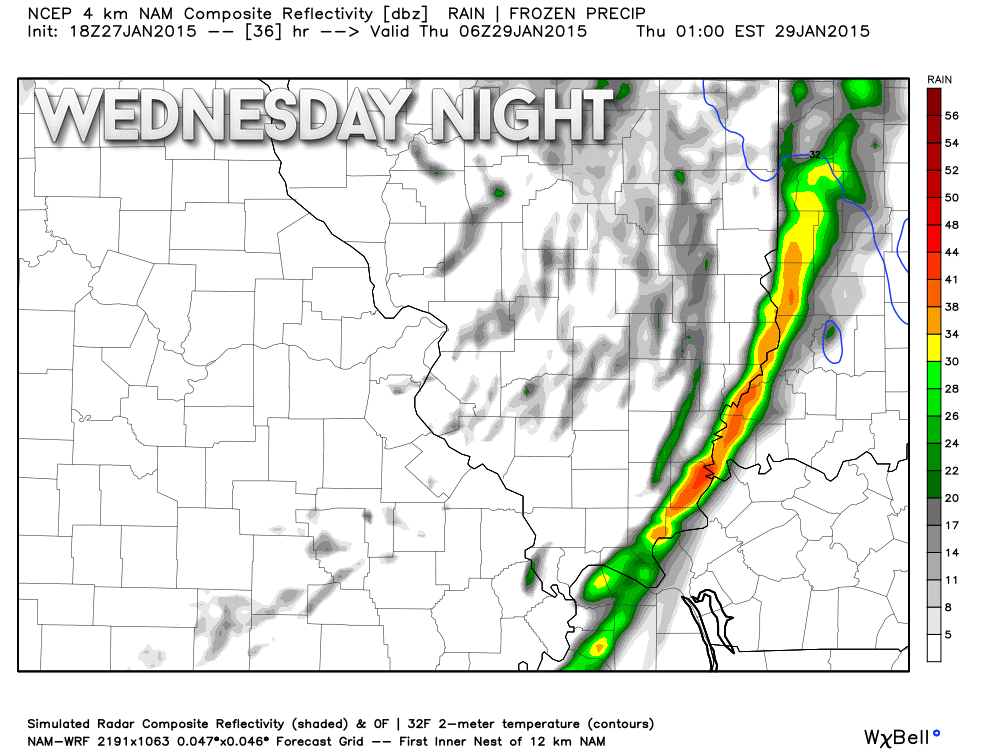
The rain event tonight will be on the light side.
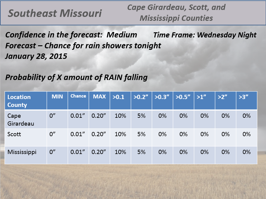
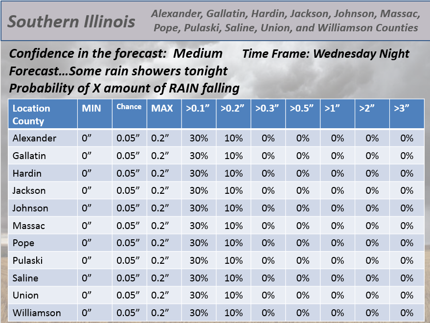
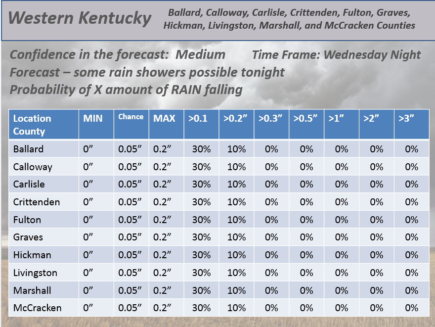
Here are the rainfall probabilities for each county. You can see that the 0.05″ is the forecast. Probabilities go down from there.
Southeast Missouri Probabilities for X amount of rain falling tonight.
Southern Illinois Probabilities for X amount of rain falling tonight.
Western Kentucky Probabilities for X amount of rain falling tonight.
Thursday into Friday will bring calm weather. Some gusty winds from time to time. Cooler temperatures on Friday.
I am watching a larger storm system for the weekend (been tracking that one for more than 10 days now). See the extended part of the blog for more information on the potential for rain or rain/snow.
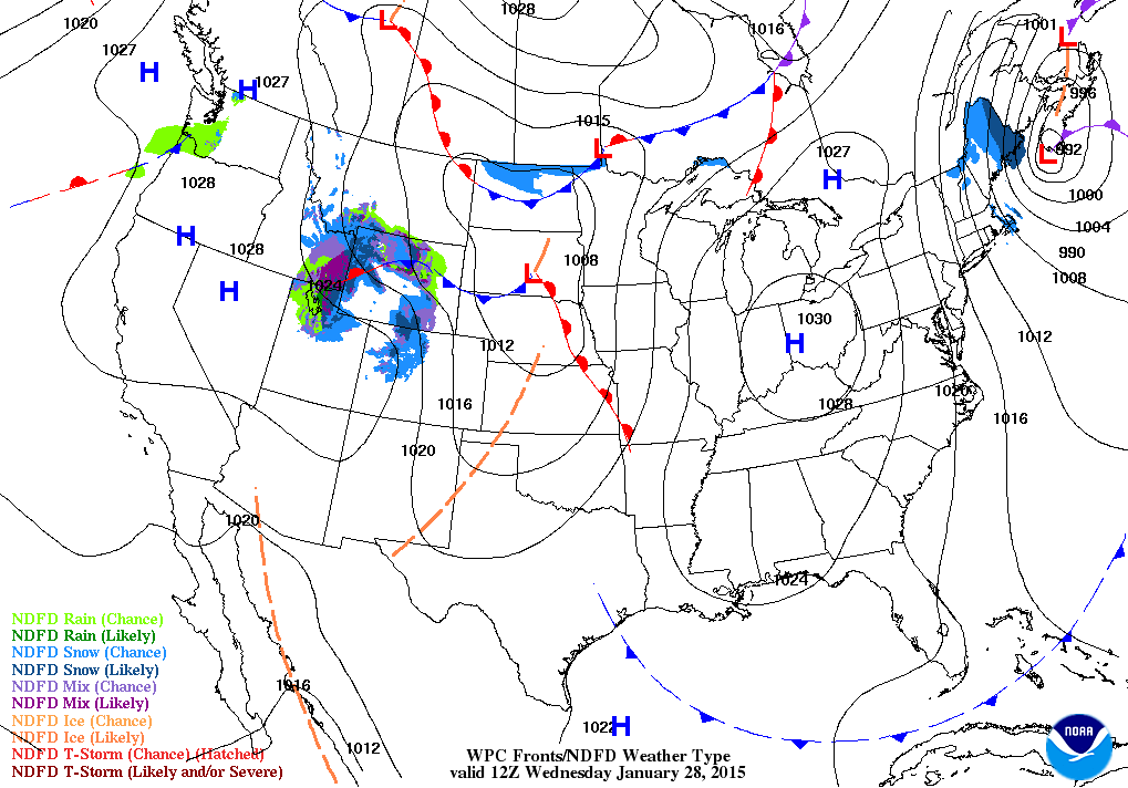
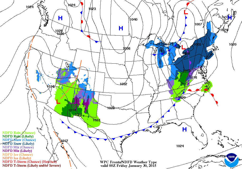
Here is your Wednesday morning weather map. You can see an advancing warm front over the Missouri Valley and an area of low pressure over South Dakota. This will be the little weather maker that might spread some showers into the region tonight.
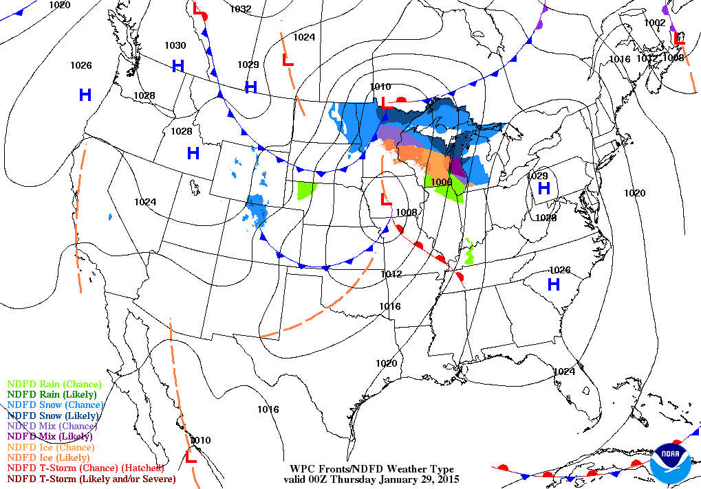
Here below is your Wednesday evening weather map
By this evening you can see the area of low pressure has advanced into Iowa. It is dragging a weak cold front through Missouri and approaching our local area. You can also see the warm front (in red). The warm front will move through our region Wednesday evening. A few showers may accompany the system.
Overall the rain chances look fairly small. Not expecting this to be a major precipitation maker.
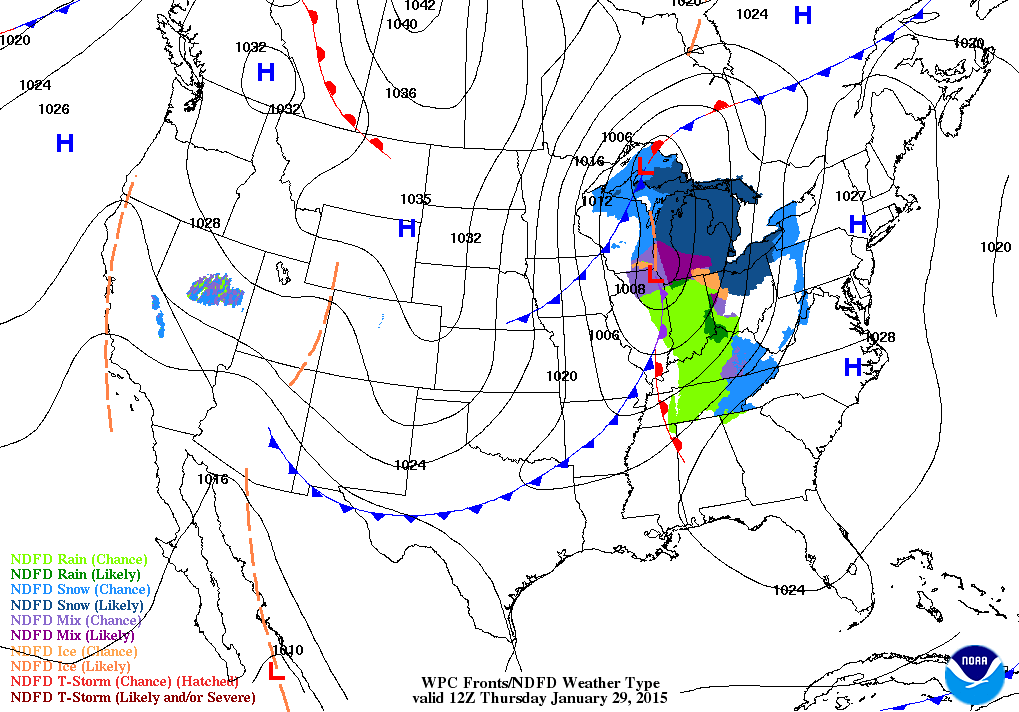
A cold front moves through the area on Thursday. This will usher in slightly colder temperatures for Friday.
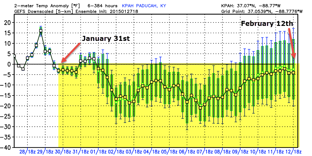
Let’s take a look at the temperatures over the coming days
This is a meteogram. It shows you the possible temperature anomalies (how many degrees above or below normal) through February 12th. Now, keep in mind that once we get past day 5 or 6 it gets a bit dicey for accuracy. The overall trend is for below normal temperatures from January 31st through February 12th. As you get to the end of the chart you see some of the model runs popping above normal (the spread is larger).
The spread is the green area. Odds definitely favor next week being cold. Image is from www.weatherbell.com
Did you know that the Weather Observatory is funded by people like you? I rely on ad’s on this blog and individual donations. PayPal also allows you to set up a monthly recurring donation. I have had several people give $5, $10, and $20 a month. A recurring donation helps keep the weather information flowing. If you enjoy this blog, the Twitter account, the Facebook interaction, the weather radars, and all of the other information then consider making a donation or setting up a recurring donation (if you don’t use PayPal then contact me through email about how you can mail a donation) beaudodson@usawx.com
Or mail me at
Beau Dodson
3954 Mermet Road
Belknap, IL
62908
Thank you for your support!

No major changes in the forecast for today.

No concerns. Some light rain or rain showers tonight.
Check out our newest sponsors $5 meal! The DQ Grill and Chill (located across from Noble Park in Paducah, Kentucky) is the newest WeatherTalk Blog sponsor! A local business helping to sponsor the weather information that you have come to love so much.
They have a Facebook Page and I encourage you to check it out. DQ Grill and Chill on Facebook


The wild card tells you where the uncertainties are in the forecast
Wild card in this forecast – the wild card will be whether or not your location picks up a rain shower later tonight (Wednesday night).

Can we expect severe thunderstorms over the next 24 to 48 hours? Remember that a severe thunderstorm is defined as a thunderstorm that produces 58 mph winds or higher, quarter size hail or larger, and/or a tornado.
Thunderstorm threat level is ZERO


Will I need to take action?
No action required today.

How much precipitation should we expect over the next few days?
Rainfall totals tonight should be in the 0.00″ to 0.25″ range. In other words, some locations won’t pick up any precipitation.
A bigger system should impact our region later this weekend. Some snow or rain/snow? See extended part of the blog below.
We have a new sponsor! G&C Multi-Services out of Paducah, Kentucky. G & C Multi-Services is a service provider in Western Kentucky that provides industrial and commercial equipment fabrication, machine troubleshooting, repair and maintenance, and installation. They can custom fabricate steel, stainless, and aluminum products per customer specifications.
Visit their web-site here. Or click the ad below! They have a Facebook page and it can be viewed here.


No winter weather in the forecast today.
I am watching a potential winter weather maker for the weekend. See discussion below.

This section of the blog is speculative forecast information. Because it is past the range of what meteorologists can forecast accurately, it should be considered speculation. Anything past day 5 is considered a long range forecast.
For the past 2 weeks I have been telling you that the coming weekend into the first part of February would turn colder.
And, it will.
The question has been whether or not we might see a storm system mix in with the colder air. And that remains the question in this update.
You can see the developing storm system on the Friday weather map – out over the southwest United States
I have been monitoring a storm system for this coming weekend for some time now. That system is almost certain to develop. It will likely spread precipitation into our region by Saturday night and Sunday. And that is where the certainties end.
The data over the last few days has wavered back and forth between rain, snow, and rain/snow. Today a lot of the data moved towards rain. However, I am not yet sold on this idea.
Climatologically speaking we are moving into peak snow season. A weak storm system moving into our region with some cold air in place certainly runs the risk of producing some wintry precipitation.
We will have some cold air in the region on Saturday into Saturday night. The path of the low pressure is going to be key to this event and the intensity of the moisture return.
If the low travels to our south then that will push up the odds of snow across portions of our area. If the low travels over our area then snow changing to rain will be more common. Perhaps ending as snow.
If the low travels north of us…well then rain will be the dominate precipitation type.
It is hard, at this point, to buy into one model solution over the other. The storm system will need to be better sampled by the upper air data before the models can be trusted.
Arguments could be made by either side (the rain vs snow side).
We will have a storm system track across our region this weekend. Stay tuned if you have travel plans.
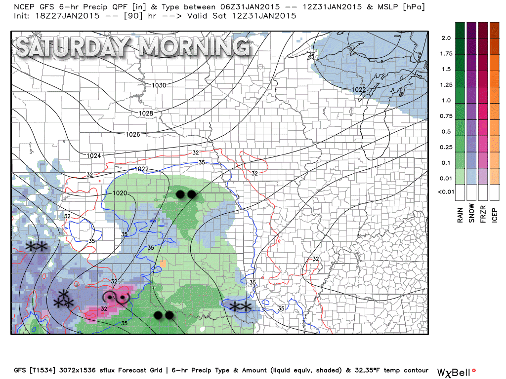
Here is the GFS model for Saturday morning – the two black dots represent rain…snowflakes are snow 🙂 Pink area is ice.
Images are from www.weatherbell.com
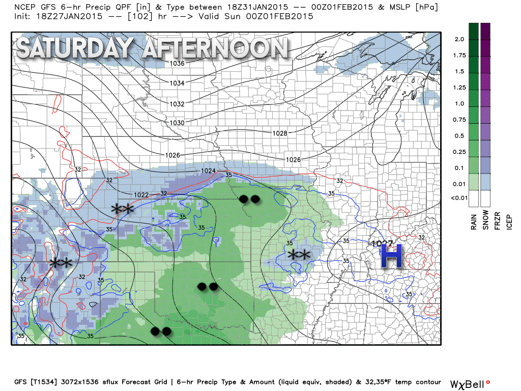
Let’s take a look at how much precipitation might fall with the weekend storm system. Amounts are going up.
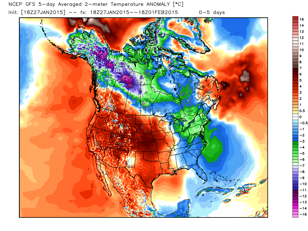
Let’s take a look at the latest GFS temperature anomaly maps. Anomaly maps tell you how much above or below normal temperatures will be. These are 5 day averages. Dates are at the top of each image.
This first map is for today into the first part of upcoming weekend. Notice the red colors near our region? That means that temperatures will average above normal for this 5 day period. The coldest temperatures are well to the northeast over the Great Lakes and New England. Remember that I told you the cold air would be centered over that region…at least for now.
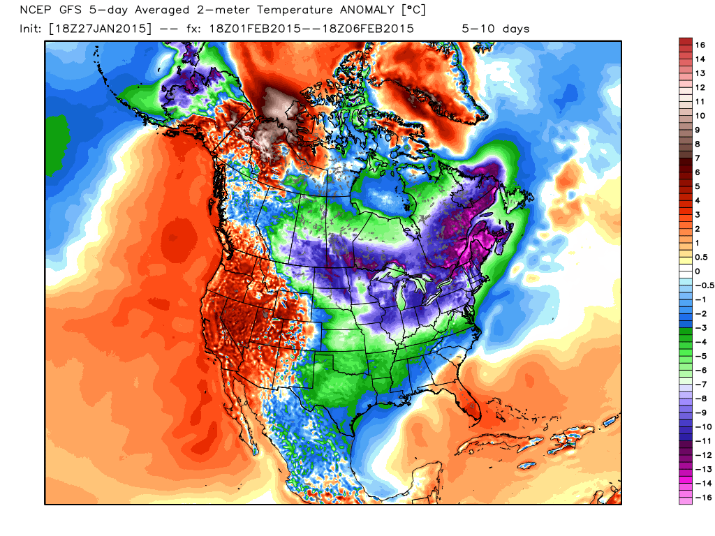
But, check out the next map – below it.
This next map takes us from February 1st into next week. Notice how blue it is? That means temperatures are going to become quite a bit colder as we move into next week.
The question is…how cold. Some of that may depend on how the weekend storm unfolds. Obviously if we have snow cover by early next week then temperatures will be a lot colder.
Another chance of precipitation may arrive around next Tuesday or Wednesday. Long way off for that one. Another system perhaps towards the following weekend.

Who do you trust for your weather information and who holds them accountable?
I have studied weather in our region since the late 1970’s. I have 37 years of experience in observing our regions weather patterns. My degree is in Broadcast Meteorology from Mississippi State University and an Associate of Science (AS). I am currently working on my Bachelor’s Degree in Geoscience. Just need to finish two Spanish classes!
I am a member of the American Meteorological Society. I am a NOAA Weather-Ready Nation Ambassador. And, I am the Meteorologist for McCracken County Emergency Management.
I own and operate the Southern Illinois Weather Observatory.
There is a lot of noise on the internet. A lot of weather maps are posted without explanation. Over time you should learn who to trust for your weather information.
My forecast philosophy is simple and straight forward.
- Communicate in simple terms
- To be as accurate as possible within a reasonable time frame before an event
- Interact with you on Twitter, Facebook, and the blog
- Minimize the “hype” that you might see on television or through other weather sources
- Push you towards utilizing wall-to-wall LOCAL TV coverage during severe weather events
I am a recipient of the Mark Trail Award, WPSD Six Who Make A Difference Award, Kentucky Colonel, and the Caesar J. Fiamma” Award from the American Red Cross. In 2009 I was presented with the Kentucky Office of Highway Safety Award. I was recognized by the Kentucky House of Representatives for my service to the State of Kentucky leading up to several winter storms and severe weather outbreaks.
If you click on the image below you can read the Kentucky House of Representatives Resolution.

I am also President of the Shadow Angel Foundation which serves portions of western Kentucky and southern Illinois.

We have regional radars and local city radars – if a radar does not seem to be updating then try another one. Occasional browsers need their cache cleared. You may also try restarting your browser. That usually fixes the problem. Occasionally we do have a radar go down. That is why I have duplicates. Thus, if one fails then try another one.
If you have any problems then please send me an email beaudodson@usawx.com
WEATHER RADAR PAGE – Click here —
We also have a new national interactive radar – you can view that radar by clicking here.
Local interactive city radars include St Louis, Mt Vernon, Evansville, Poplar Bluff, Cape Girardeau, Marion, Paducah, Hopkinsville, Memphis, Nashville, Dyersburg, and all of eastern Kentucky – these are interactive radars. Local city radars – click here
NOTE: Occasionally you will see ground clutter on the radar (these are false echoes). Normally they show up close to the radar sites – including Paducah.

Regional Radar – Click on radar to take you our full radar page.


Regional Radar

Please visit your local National Weather Service Office by clicking here. The National Weather Service Office, for our region, is located in Paducah, Kentucky. They have a lot of maps and information on their site. Local people…local forecasters who care about our region.


Here is the official 6-10 day and 8-14 day temperature and precipitation outlook. Check the date stamp at the top of each image (so you understand the time frame).
The forecast maps below are issued by the Weather Prediction Center (NOAA).


The latest 8-14 day temperature and precipitation outlook. Note the dates are at the top of the image. These maps DO NOT tell you how high or low temperatures or precipitation will be. They simply give you the probability as to whether temperatures or precipitation will be above or below normal.


Many of my graphics are from www.weatherbell.com – a great resource for weather data, model data, and more


This blog was inspired by ABC 33/40’s Alabama Weather Blog – view their blog
Current tower cam view from the Weather Observatory- Click here for all cameras.

Southern Illinois Weather Observatory

The Weather Observatory

Southern Illinois Weather Observatory
WSIL TV 3 has a number of tower cameras. Click here for their tower camera page & Illinois Road Conditions

Marion, Illinois
WPSD TV 6 has a number of tower cameras. Click here for their tower camera page & Kentucky Road Conditions & Kentucky Highway and Interstate Cameras

Downtown Paducah, Kentucky
Benton, Kentucky Tower Camera – Click here for full view

Benton, Kentucky

I24 Paducah, Kentucky

I24 Mile Point 9 – Paducah, KY

I24 – Mile Point 3 Paducah, Kentucky

You can sign up for my AWARE email by clicking here I typically send out AWARE emails before severe weather, winter storms, or other active weather situations. I do not email watches or warnings. The emails are a basic “heads up” concerning incoming weather conditions.