January 27, 2019
** Black ice possible Monday PM into Tuesday AM **
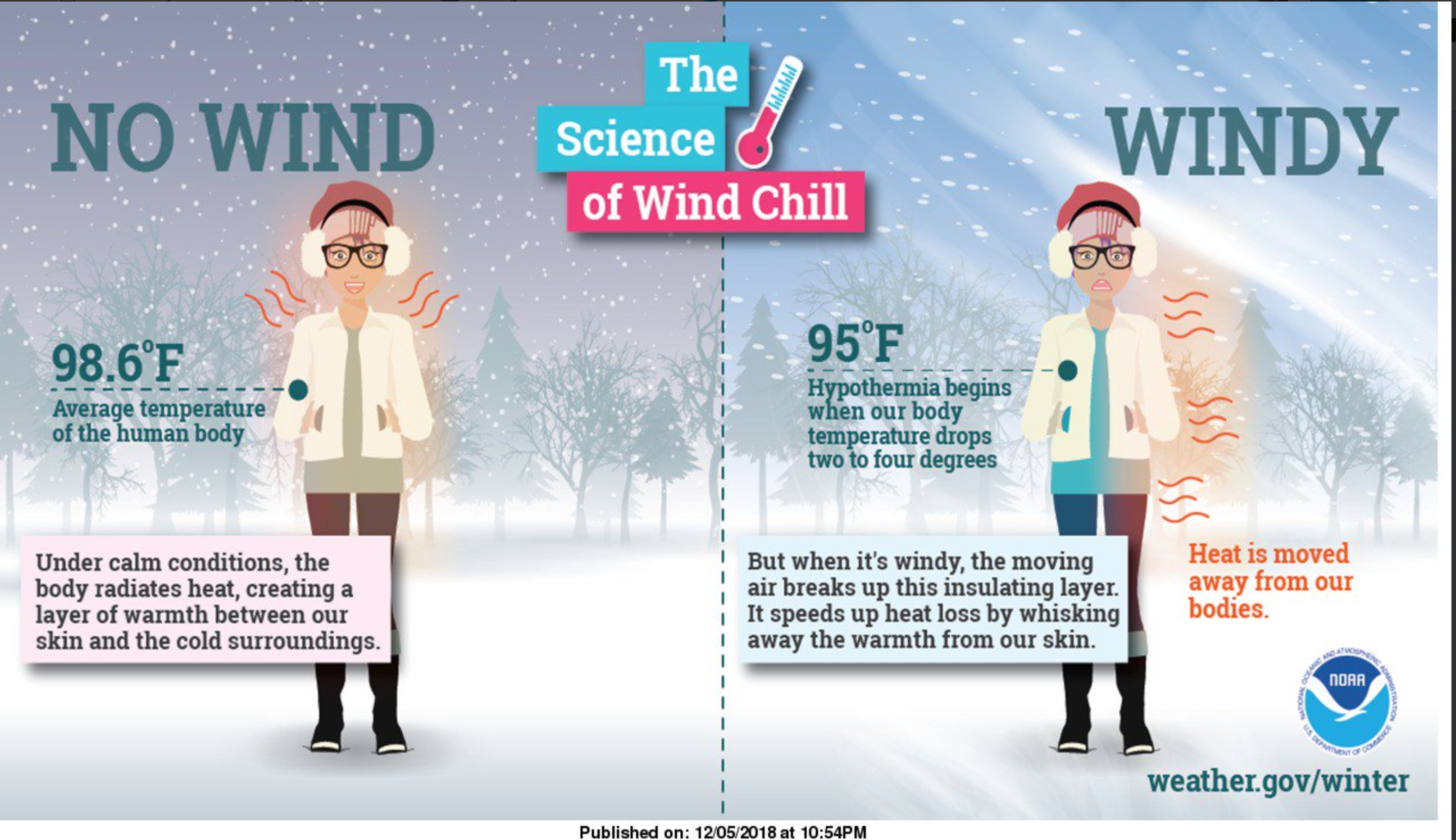
** Wind chill alert Monday night into Wednesday morning **
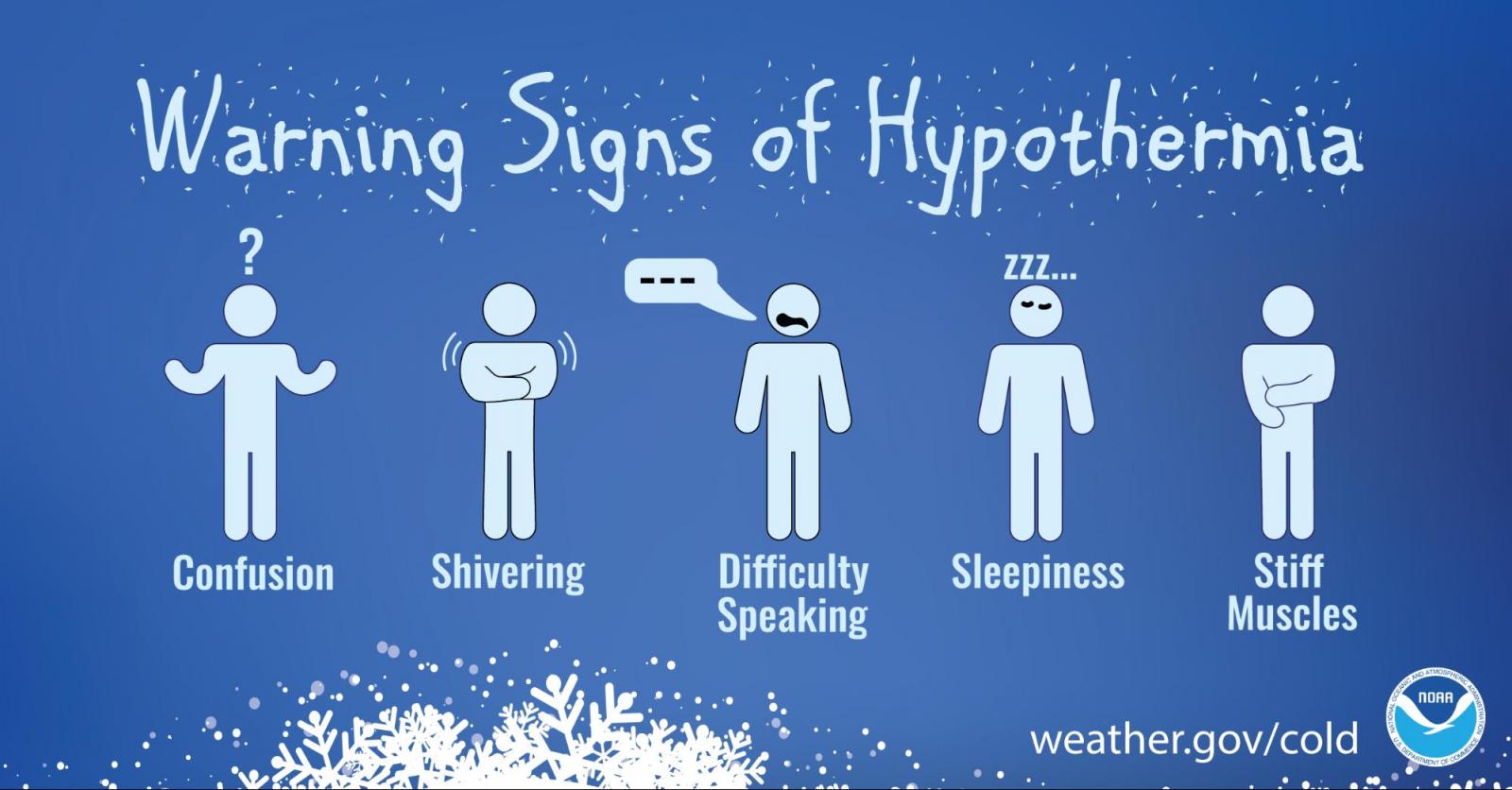
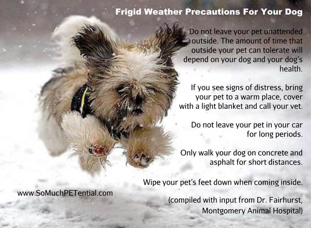
Don’t forget our outdoor pets during this cold snap!
There are a few light sprinkles/flurries around the area this morning. Nothing to write home about.
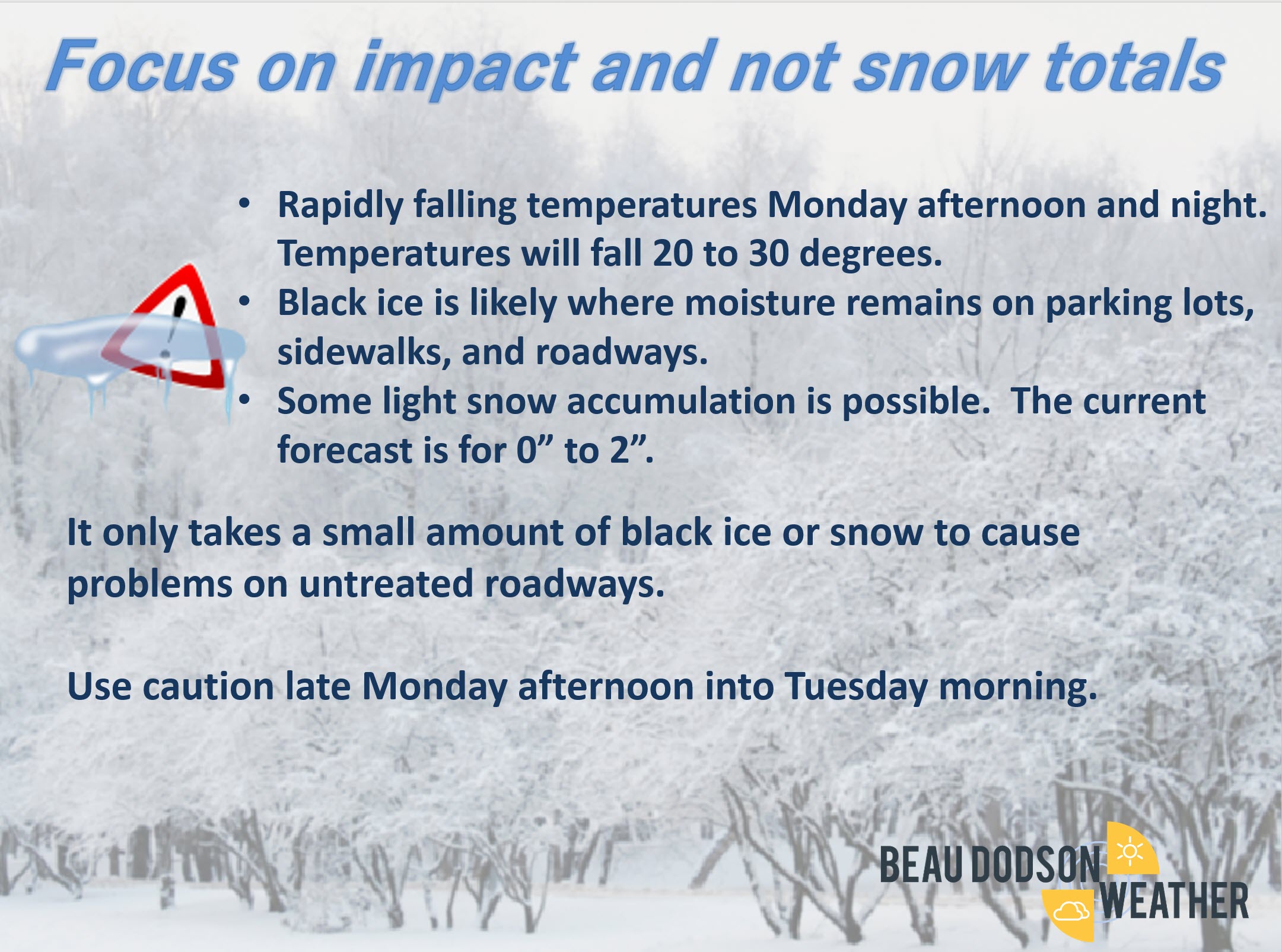
The big weather story is going to arrive Monday. Rapidly falling temperatures with gusty winds along an arctic cold front. This will be the coldest air of the season.
Historic cold is forecast to our north.
This front is going to bring actual air temperatures of -20 to -30 and wind chill values of -30 to -50 across portions of northern Illinois (other areas, as well).
Our region will pop into the 40’s ahead of the cold front Monday morning/afternoon. Temperatures will them plummet behind the front.
By Tuesday morning we will be in the teens.
Wednesday morning will deliver single digits across most of my forecast area. Thursday morning will deliver single digits to lower teens.
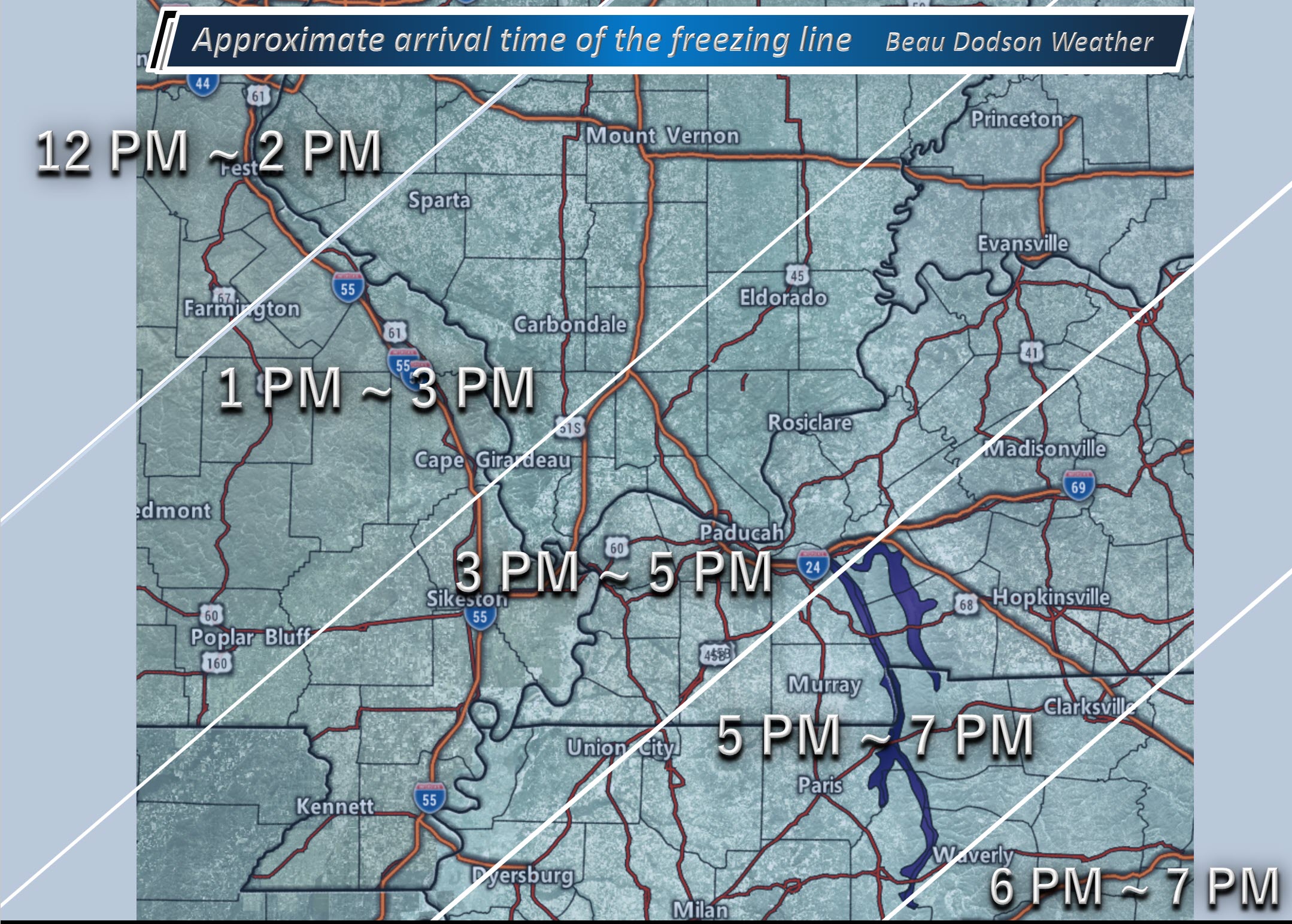
Monday afternoon, a band of rain showers will accompany the front. The rain may end as snow showers Monday evening and night.
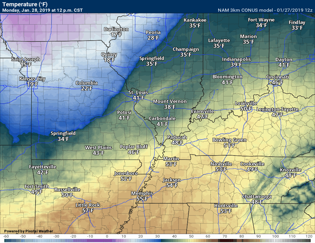
Here is the NAM model animation of the colder air arriving. The timestamp is located in the upper left portion of the animation.


January 27, 2019
Sunday’s Forecast: Mostly cloudy. A sprinkle or flurry possible.
My confidence in the forecast verifying: High (70% confidence in the forecast)
Temperature range: MO Bootheel 46° to 48° SE MO 42° to 46° South IL 36° to 44° West KY 42° to 46° NW TN 44° to 48°
Wind direction and speed: Variable wind 6 to 12 mph
Wind chill or heat index (feels like) temperature forecast: 35° to 40°
What is the chance/probability of precipitation? MO Bootheel 10% MO 20% IL 20% KY 20% TN 10%
Note, what does the % chance actually mean? A 20% chance of rain does not mean it won’t rain. It simply means most areas will remain dry
Coverage of precipitation: None to isolated
Is flash flooding anticipated? No
Will there be accumulating snow or ice? Temperatures will rise above freezing. If there were issues it would be early in the day.
Will non-accumulating snow or ice occur? A snow flurry possible
Are icy road conditions anticipated? Monitor Sunday morning. Some slick spots possible before temperatures rise above freezing. This would be in areas that received accumulating precipitation on Saturday.
Is severe weather expected? No
The NWS officially defines severe weather as 58 mph wind or great, 1″ hail or larger, and/or tornadoes
Is lightning anticipated? No
What impacts are anticipated from the weather? Perhaps some wet roadways. Monitor the risk of icy roads early in the day. This would be in areas that received accumulating precipitation on Saturday.
Should I cancel my outdoor plans? No
UV Index: 2 Low
Sunrise: 7:02 AM
Sunday Night Forecast Details:
Forecast: Decreasing clouds.
My confidence in the forecast verifying: High (70% confidence in the forecast)
Temperature range: MO Bootheel 26° to 32° SE MO 28° to 32° South IL 28° to 32° West KY 28° to 32° NW TN 32° to 34°
Wind direction and speed: Becoming south at 5 to 10 mph
Wind chill or heat index (feels like) temperature forecast: 25° to 30°
What is the chance/probability of precipitation? MO Bootheel 0% MO 0% IL 0% KY 0% TN 0%
Note, what does the % chance actually mean? A 20% chance of rain does not mean it won’t rain. It simply means most areas will remain dry
Coverage of precipitation: None
Is flash flooding anticipated? No
Will there be accumulating snow or ice? No
Will non-accumulating snow or ice occur? No
Are icy road conditions anticipated? No
Is severe weather expected? No
The NWS officially defines severe weather as 58 mph wind or great, 1″ hail or larger, and/or tornadoes
Is lightning anticipated? No
What impacts are anticipated from the weather? None
Should I cancel my outdoor plans? No
Sunset: 5:14 PM
Moonrise: 11:59 PM
The phase of the moon: Waning Gibbous
Moonset: 11:22 AM
January 28, 2019
Monday’s Forecast: Warmer. Becoming windy. Increasing clouds from northwest to southeast. An incoming cold front will reach our northern counties between 11 AM and 1 PM. The front then pushes across the entire area by 10 PM. A band of light rain showers may accompany the front. Rain may end as snow flurries or snow showers. Accumulation totals of zero to one inch. Black ice may develop as moisture remains on roadways as temperatures fall. Rain totals of 0.00″ to 0.15″. Snow totals of 0″ to 1″.
My confidence in the forecast verifying: High (80% confidence in the forecast)
Temperature range: ** REMEMBER ** Temperatures will fall as the front pushes through the region. MO Bootheel 50° to 55° SE MO 45° to 50° South IL 40° to 46° West KY 46° to 52° NW TN 50° to 54°
Wind direction and speed: Becoming southwest at 15 to 25 mph and gusty. Becoming northwest behind the front.
Wind chill or heat index (feels like) temperature forecast: N/A
What is the chance/probability of precipitation? MO Bootheel 60% MO 60% IL 60% KY 60% TN 60%
Note, what does the % chance actually mean? A 20% chance of rain does not mean it won’t rain. It simply means most areas will remain dry.
Coverage of precipitation: Scattered to perhaps a broken band of light showers.
Is flash flooding anticipated? No
Will there be accumulating snow or ice? Unlikely
Will non-accumulating snow or ice occur? Rain may end as snow flurries or a snow shower.
Are icy road conditions anticipated? Small chance. Black ice is a concern as temperature rapidly fall.
Is severe weather expected? No
The NWS officially defines severe weather as 58 mph wind or great, 1″ hail or larger, and/or tornadoes
Is lightning anticipated? No
What impacts are anticipated from the weather? Wet roadways. Breezy. Monitor temperatures as they drop behind the front.
Should I cancel my outdoor plans? No, but monitor radars.
UV Index: 1 Low
Sunrise: 7:02 AM
Click here for your interactive local city-view radars & regional radars.
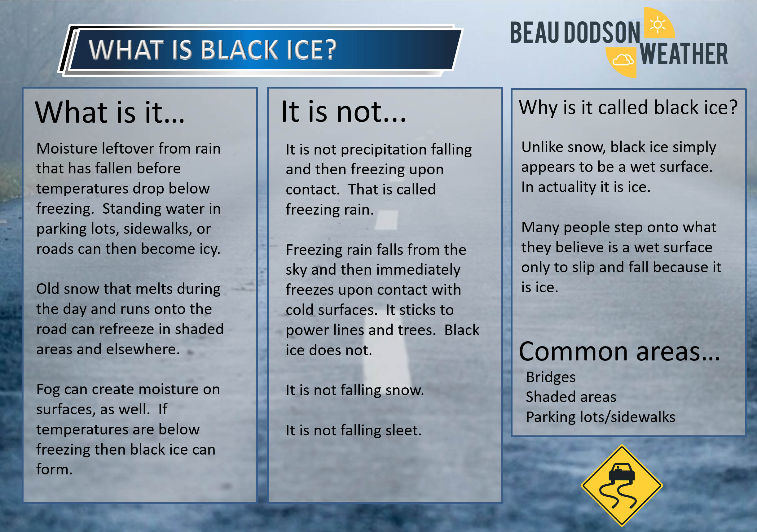
Monday night Forecast: Wind chill alert. Cloudy. A few rain showers or snow showers. Any precipitation will quickly end. Watch for black ice. Small chance of accumulating snow.
My confidence in the forecast verifying: Medium (60% confidence in the forecast)
Temperature range: MO Bootheel 16° to 20° SE MO 12° to 16° South IL 10° to 15° West KY 15° to 20° NW TN 16° to 20°
Wind direction and speed: Becoming northwest at 7 to 14 mph with gusts to 30
Wind chill or heat index (feels like) temperature forecast: -5° to 10°
What is the chance/probability of precipitation? MO Bootheel 30% MO 20% IL 20% KY 40% TN 50%
Note, what does the % chance actually mean? A 20% chance of rain does not mean it won’t rain. It simply means most areas will remain dry
Coverage of precipitation: Scattered earlly. Any precipitation will quickly end.
Is flash flooding anticipated? No
Will there be accumulating snow or ice? Low-end chance of a dusting to an inch.
Will non-accumulating snow or ice occur? Scattered snow showers are possible as precipitation ends.
Are icy road conditions anticipated? Black ice is possible.
Is severe weather expected? No
The NWS officially defines severe weather as 58 mph wind or great, 1″ hail or larger, and/or tornadoes
Is lightning anticipated? No
What impacts are anticipated from the weather? Rapidly falling temperatures. Low wind chill values. Watch for black ice if moisture remains on roadways as temperatures fall.
Should I cancel my outdoor plans? No, but monitor radars and temperatures.
Sunset: 5:15 PM
Moonrise: 12:49 AM
The phase of the moon: Last Quarter
Moonset: 11:55 AM
January 29, 2019
Tuesday’s Forecast: Partly cloudy. Snow flurries or snow showers possible.
My confidence in the forecast verifying: High (70% confidence in the forecast)
Temperature range: MO Bootheel 30° to 34° SE MO 23° to 26° South IL 22° to 28° West KY 26° to 28° NW TN 28° to 30°
Wind direction and speed: Northwest 10 to 20 mph and gusty.
Wind chill or heat index (feels like) temperature forecast: -2 to 14 above
What is the chance/probability of precipitation? MO Bootheel 30% MO 30% IL 30% KY 30% TN 30%
Note, what does the % chance actually mean? A 20% chance of rain does not mean it won’t rain. It simply means most areas will remain dry.
Coverage of precipitation: Scattered
Is flash flooding anticipated? No
Will there be accumulating snow or ice? Monitor
Will non-accumulating snow or ice occur? Monitor
Are icy road conditions anticipated? Monitor updates
Is severe weather expected? No
The NWS officially defines severe weather as 58 mph wind or great, 1″ hail or larger, and/or tornadoes
Is lightning anticipated? No
What impacts are anticipated from the weather? Low wind chill values will be an issue.
Should I cancel my outdoor plans? Monitor updates
UV Index: 2 Low
Sunrise: 7:01 AM
Tuesday night Forecast: Wind chill alert. A few clouds with snow flurries or snow showers possible. Bitterly cold.
My confidence in the forecast verifying: Medium (50% confidence in the forecast)
Temperature range: MO Bootheel 13° to 16° SE MO 6° to 14° South IL 0° to 8° West KY 6° to 10° NW TN 12° to 14°
Wind direction and speed: Northwest at 7 to 14 mph
Wind chill or heat index (feels like) temperature forecast: -8° to 10°
What is the chance/probability of precipitation? MO Bootheel 10% MO 20% IL 20% KY 20% TN 20%
Note, what does the % chance actually mean? A 20% chance of rain does not mean it won’t rain. It simply means most areas will remain dry
Coverage of precipitation: Isolated to scattered
Is flash flooding anticipated? No
Will there be accumulating snow or ice? Monitor updates
Will non-accumulating snow or ice occur? Yes
Are icy road conditions anticipated? Monitor
Is severe weather expected? No
The NWS officially defines severe weather as 58 mph wind or great, 1″ hail or larger, and/or tornadoes
Is lightning anticipated? No
What impacts are anticipated from the weather? Bitterly cold air temps and wind chill values.
Should I cancel my outdoor plans? Have a plan B because of bitterly cold air.
Sunset: 5:16 PM
Moonrise: 1:51 AM
The phase of the moon: Waning Crescent
Moonset: 12:31 PM
![]()
January 30, 2019
Wednesday’s Forecast: Cold. Low wind chill values. Snow showers possible.
My confidence in the forecast verifying: Medium (60% confidence in the forecast)
Temperature range: MO Bootheel 18° to 22° SE MO 10° to 14° South IL 8° to 14° West KY 14° to 18° NW TN 18° to 22°
Wind direction and speed: West and northwest at 8 to 16 mph
Wind chill or heat index (feels like) temperature forecast: -6 to 10 above zero
What is the chance/probability of precipitation? MO Bootheel 20% MO 30% IL 30% KY 30% TN 30%
Note, what does the % chance actually mean? A 20% chance of rain does not mean it won’t rain. It simply means most areas will remain dry.
Coverage of precipitation: Scattered
Is flash flooding anticipated? No
Will there be accumulating snow or ice? Monitor updates
Will non-accumulating snow or ice occur? Snow showers are possible
Are icy road conditions anticipated? Monitor updates
Is severe weather expected? No
The NWS officially defines severe weather as 58 mph wind or great, 1″ hail or larger, and/or tornadoes
Is lightning anticipated? No
What impacts are anticipated from the weather? Cold wind chill temperatures. Monitor snow chances.
Should I cancel my outdoor plans? No
UV Index: 2 Low
Sunrise: 7:00 AM
Wednesday night Forecast: Wind chill alert. A few clouds with snow flurries possible. Bitterly cold.
My confidence in the forecast verifying: Medium (50% confidence in the forecast)
Temperature range: MO Bootheel 8° to 10° SE MO 4° to 8° South IL -2° to 5° West KY 4° to 8° NW TN 6° to 10°
Wind direction and speed: North and northeast at 6 to 12 mph
Wind chill or heat index (feels like) temperature forecast: -10° to 5°
What is the chance/probability of precipitation? MO Bootheel 0% MO 0% IL 0% KY 0% TN 0%
Note, what does the % chance actually mean? A 20% chance of rain does not mean it won’t rain. It simply means most areas will remain dry
Coverage of precipitation: None to isolated
Is flash flooding anticipated? No
Will there be accumulating snow or ice? No
Will non-accumulating snow or ice occur? A snow shower possible.
Are icy road conditions anticipated? Monitor updates
Is severe weather expected? No
The NWS officially defines severe weather as 58 mph wind or great, 1″ hail or larger, and/or tornadoes
Is lightning anticipated? No
What impacts are anticipated from the weather? Bitterly cold.
Should I cancel my outdoor plans? Have a plan B because of bitterly cold air.
Sunset: 5:17 PM
Moonrise: 2:50 AM
The phase of the moon: Waning Crescent
Moonset: 1:10 PM
January 31, 2019
Thursday’s Forecast: Partly cloudy and cold.
My confidence in the forecast verifying: Medium (60% confidence in the forecast)
Temperature range: MO Bootheel 28° to 34° SE MO 26° to 28° South IL 22° to 26° West KY 26° to 30° NW TN 30° to 32°
Wind direction and speed: East at 8 to 16 mph
Wind chill or heat index (feels like) temperature forecast: 15 to 25 above zero
What is the chance/probability of precipitation? MO Bootheel 0% MO 0% IL 0% KY 0% TN 0%
Note, what does the % chance actually mean? A 20% chance of rain does not mean it won’t rain. It simply means most areas will remain dry.
Coverage of precipitation: None
Is flash flooding anticipated? No
Will there be accumulating snow or ice? No
Will non-accumulating snow or ice occur? No
Are icy road conditions anticipated? No
Is severe weather expected? No
The NWS officially defines severe weather as 58 mph wind or great, 1″ hail or larger, and/or tornadoes
Is lightning anticipated? No
What impacts are anticipated from the weather? None
Should I cancel my outdoor plans? No
UV Index: 3 Moderate
Sunrise: 6:59 AM
Thursday night Forecast: Cloudy. A chance of snow showers.
My confidence in the forecast verifying: Low (30% confidence in the forecast)
Temperature range: MO Bootheel 24° to 28° SE MO 22° to 26° South IL 15° to 20° West KY 20° to 24° NW TN 24° to 28°
Wind direction and speed: East at 5 to 10 mph
Wind chill or heat index (feels like) temperature forecast: 8 to 16
What is the chance/probability of precipitation? MO Bootheel 30% MO 30% IL 30% KY 30% TN 30%
Note, what does the % chance actually mean? A 20% chance of rain does not mean it won’t rain. It simply means most areas will remain dry
Coverage of precipitation: Scattered
Is flash flooding anticipated? No
Will there be accumulating snow or ice? It is possible
Will non-accumulating snow or ice occur? Yes
Are icy road conditions anticipated? Monitor
Is severe weather expected? No
The NWS officially defines severe weather as 58 mph wind or great, 1″ hail or larger, and/or tornadoes
Is lightning anticipated? No
What impacts are anticipated from the weather? Icy roadways.
Should I cancel my outdoor plans? No, not yet. Monitor updates.
Sunset: 5:18 PM
Moonrise: 3:48 AM
The phase of the moon: Waning Crescent
Moonset: 1:53 PM
February 1, 2019
Friday’s Forecast: Cloudy. A chance of rain or snow showers.
My confidence in the forecast verifying: Low (30% confidence in the forecast)
Temperature range: MO Bootheel 35° to 40° SE MO 34° to 38° South IL 34° to 38° West KY 36° to 40° NW TN 36° to424°
Wind direction and speed:
Wind chill or heat index (feels like) temperature forecast: 20 to 30
What is the chance/probability of precipitation? MO Bootheel 20% MO 20% IL 0% KY 20% TN 30%
Note, what does the % chance actually mean? A 20% chance of rain does not mean it won’t rain. It simply means most areas will remain dry.
Coverage of precipitation: Scattered
Is flash flooding anticipated? No
Will there be accumulating snow or ice? Monitor
Will non-accumulating snow or ice occur? Monitor
Are icy road conditions anticipated? Monitor updates
Is severe weather expected? No
The NWS officially defines severe weather as 58 mph wind or great, 1″ hail or larger, and/or tornadoes
Is lightning anticipated? No
What impacts are anticipated from the weather? Wet roadways. Monitor.
Should I cancel my outdoor plans? No, but monitor updates.
UV Index: 3 Moderate
Sunrise: 6:59 AM
Friday night Forecast: A few clouds.
My confidence in the forecast verifying: Low (30% confidence in the forecast)
Temperature range: MO Bootheel 24° to 28° SE MO 23° to 26° South IL 24° to 26° West KY 24° to 28° NW TN 25° to 30°
Wind direction and speed: Southeast at 5 to 10 mph
Wind chill or heat index (feels like) temperature forecast: 20 to 30
What is the chance/probability of precipitation? MO Bootheel 0% MO 0% IL 0% KY 0% TN 0%
Note, what does the % chance actually mean? A 20% chance of rain does not mean it won’t rain. It simply means most areas will remain dry
Coverage of precipitation: None
Is flash flooding anticipated? No
Will there be accumulating snow or ice? No
Will non-accumulating snow or ice occur? No
Are icy road conditions anticipated? No
Is severe weather expected? No
The NWS officially defines severe weather as 58 mph wind or great, 1″ hail or larger, and/or tornadoes
Is lightning anticipated? No
What impacts are anticipated from the weather? None
Should I cancel my outdoor plans? No
Sunset: 5:19 PM
Moonrise: 4:41 AM
The phase of the moon: Waning Crescent
Moonset: 2:40 PM
February 2, 2019
Saturday’s Forecast: Partly cloudy.
My confidence in the forecast verifying: Medium (40% confidence in the forecast)
Temperature range: MO Bootheel 40° to 45° SE MO 40° to 45° South IL 40° to 45° West KY 40° to 45° NW TN 40° to 45°
Wind direction and speed: South at 5 t0 10 mph
Wind chill or heat index (feels like) temperature forecast:
What is the chance/probability of precipitation? MO Bootheel 0% MO 0% IL 0% KY 0% TN 0%
Note, what does the % chance actually mean? A 20% chance of rain does not mean it won’t rain. It simply means most areas will remain dry.
Coverage of precipitation: None
Is flash flooding anticipated? No
Will there be accumulating snow or ice? No
Will non-accumulating snow or ice occur? No
Are icy road conditions anticipated? No
Is severe weather expected? No
The NWS officially defines severe weather as 58 mph wind or great, 1″ hail or larger, and/or tornadoes
Is lightning anticipated? No
What impacts are anticipated from the weather? None
Should I cancel my outdoor plans? No
UV Index: 3 Moderate
Sunrise: 6:58AM
Saturday night Forecast: Mostly cloudy. A chance of rain showers.
My confidence in the forecast verifying: Low (30% confidence in the forecast)
Temperature range: MO Bootheel 34° to 38° SE MO 34° to38° South IL 34° to 38° West KY 34° to 38° NW TN 35° to 40°
Wind direction and speed: South at 7 to 14 mph and gusty
Wind chill or heat index (feels like) temperature forecast: 20 to 30
What is the chance/probability of precipitation? MO Bootheel 30% MO 30% IL 30% KY 30% TN 30%
Note, what does the % chance actually mean? A 20% chance of rain does not mean it won’t rain. It simply means most areas will remain dry
Coverage of precipitation: Scattered
Is flash flooding anticipated? No
Will there be accumulating snow or ice? No
Will non-accumulating snow or ice occur? No
Are icy road conditions anticipated? No
Is severe weather expected? No
The NWS officially defines severe weather as 58 mph wind or great, 1″ hail or larger, and/or tornadoes
Is lightning anticipated? No
What impacts are anticipated from the weather? Wet roadways.
Should I cancel my outdoor plans? No, but monitor updates
Sunset: 5:21 PM
Moonrise: 5:31 AM
The phase of the moon: Waning Crescent
Moonset: 3:31 PM
February 3, 2019
Sunday’s Forecast: Increasing clouds. A shower possible.
My confidence in the forecast verifying: Low (30% confidence in the forecast)
Temperature range: MO Bootheel 40° to 45° SE MO 40° to 45° South IL 40° to 45° West KY 40° to 45° NW TN 43° to 46°
Wind direction and speed: South at 6 to 12 mph
Wind chill or heat index (feels like) temperature forecast: 35 to 45
What is the chance/probability of precipitation? MO Bootheel 20% MO 20% IL 20% KY 20% TN 20%
Note, what does the % chance actually mean? A 20% chance of rain does not mean it won’t rain. It simply means most areas will remain dry.
Coverage of precipitation: Scattered
Is flash flooding anticipated? No
Will there be accumulating snow or ice? No
Will non-accumulating snow or ice occur? No
Are icy road conditions anticipated? No
Is severe weather expected? No
The NWS officially defines severe weather as 58 mph wind or great, 1″ hail or larger, and/or tornadoes
Is lightning anticipated? No
What impacts are anticipated from the weather? Wet roadways.
Should I cancel my outdoor plans? No, but monitor updates
UV Index: 2 Low
Sunrise: 6:57 AM
Sunday night Forecast: Cloudy with rain showers possible.
My confidence in the forecast verifying: Medium (40% 34° to 38° South IL 34° to 38° West KY 34° to 38° NW TN 34° to 38°
Wind direction and speed: Variable at 3 to 6 mph
Wind chill or heat index (feels like) temperature forecast: 20 to 30
What is the chance/probability of precipitation? MO Bootheel 20% MO 20% IL 20% KY 20% TN 20%
Note, what does the % chance actually mean? A 20% chance of rain does not mean it won’t rain. It simply means most areas will remain dry
Coverage of precipitation: Scattered
Is flash flooding anticipated? No
Will there be accumulating snow or ice? No
Will non-accumulating snow or ice occur? No
Are icy road conditions anticipated? No
Is severe weather expected? No
The NWS officially defines severe weather as 58 mph wind or great, 1″ hail or larger, and/or tornadoes
Is lightning anticipated? No
What impacts are anticipated from the weather? Wet roadways possible
Should I cancel my outdoor plans? No, but monitor updates
Sunset: 5:22 PM
Moonrise: 6:16 AM
The phase of the moon: Waning Crescent
Moonset: 4:23 PM