We have our first sponsor for the blog. Milner and Orr Funeral Home and Cremation Services located in Paducah, Kentucky and three other western Kentucky towns – at Milner and Orr they believe in families helping families.
![]()

This forecast update covers far southern Illinois, far southeast Missouri, and far western Kentucky. See the coverage map on the right side of the blog.
Remember that weather evolves. Check back frequently for updates, especially during active weather.
Tuesday – Quite a few clouds again today. We may see more sun over southeast Missouri than areas northeast of there. High temperatures in the upper 30’s and lower 40’s. North winds at 5-10 mph.
Morning School Bus Stop Weather – Quite a few clouds. Temperatures will be in the 30’s. North winds at 5-10 mph.
Afternoon School Bus Stop Weather – Quite a few clouds. Temperatures will be in the upper 30’s to lower 40’s. North winds at 5-10 mph.
Tuesday night – Partly cloudy and chilly. Low temperatures in the 20’s. North/northeast winds at 5-10 mph
Wednesday – Mostly sunny. A bit warmer. Highs mainly in the 40’s. Southeast winds at 5-10 mph. Gusts to 15 mph.
Wednesday night – Becoming cloudy with a shower possible. Low temperatures in the middle to upper 30’s. Southerly winds at 5-10 mph. Gusts to 15 mph.
Thursday – Cloudy with highs from 46 to 52 degrees. South winds at 10-15 mph.

Current Temperatures Around The Local Area


An explanation of what is happening in the atmosphere over the coming days…
Well, some of the snow showers on Monday produced a dusting to an inch or two of snow over our far eastern counties. Mainly east of the Land Between the Lakes. A bit out of my forecast county area. The snow showers developed as a weak system pushed through the area moving from the northwest towards the southeast.
That system has pulled away from the area.
The weather will be fairly calm over the next few days. We will have a few showers on Wednesday night. Temperatures will be warm enough that we won’t have to worry about frozen precipitation.
I continue to track much colder air as we move into the weekend and especially the first week of February. See the long range discussion for details.
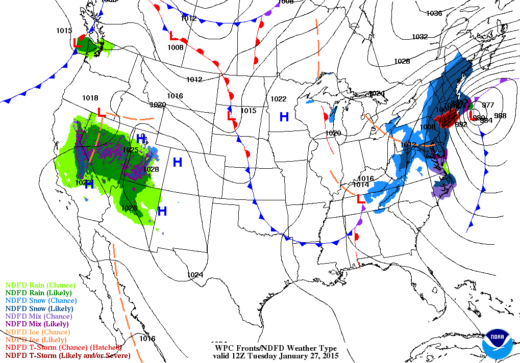
Here is your Tuesday morning weather map – you can see the big blizzard over the northeast United States
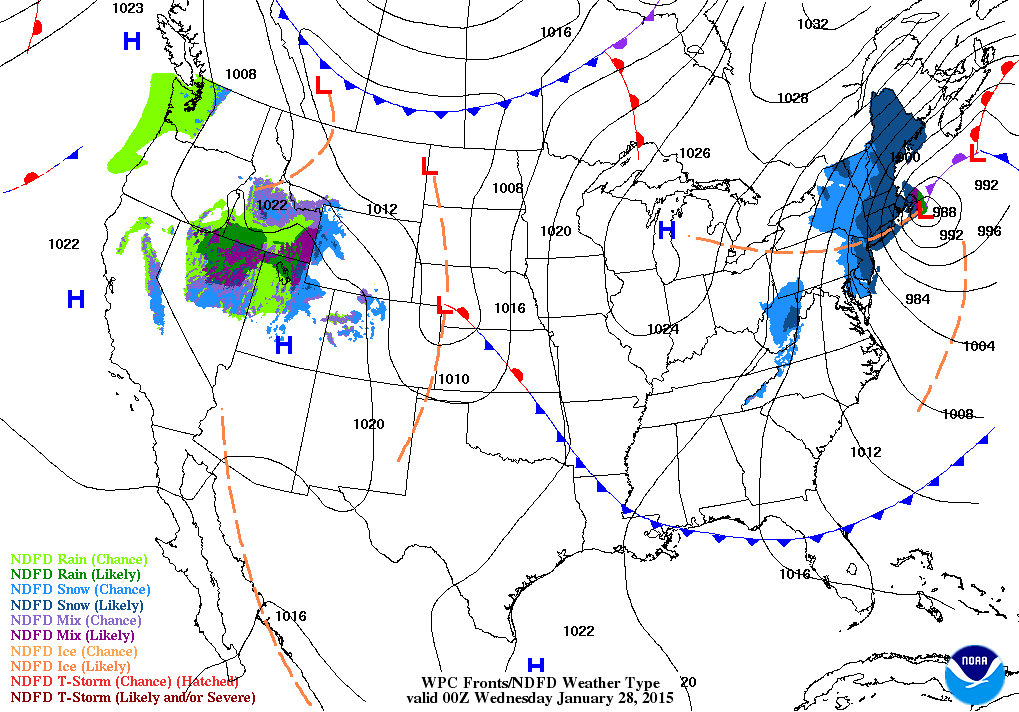
Here is your Tuesday evening weather map
Did you know that the Weather Observatory is funded by people like you? I rely on ad’s on this blog and individual donations. PayPal also allows you to set up a monthly recurring donation. I have had several people give $5, $10, and $20 a month. A recurring donation helps keep the weather information flowing. If you enjoy this blog, the Twitter account, the Facebook interaction, the weather radars, and all of the other information then consider making a donation or setting up a recurring donation (if you don’t use PayPal then contact me through email about how you can mail a donation) beaudodson@usawx.com
Thank you for your support!

We have a new spot that will appear on the blog from time to time – Ask The Weatherman
Mrs. Tiffany Blazina (Curriculum Coach – Middle School and High School) contacted me about answering some questions from some of the students from the Crittenden County Middle School in Marion, Kentucky. Home of the Rockets!
Mrs. Mattea Meadows, Language Arts teacher, led this project and is teaching the class about meteorology. They sent me a few questions. I will try to get to them over the coming week or two.

This question is from Riley Gobin
Which do you think is worse? A tornado or a hurricane?
Thanks, Riley. That is a great question.
There are some significant differences between a tornado and a hurricane. A tornado is normally short lived. Often times a tornado will only last a few minutes and only travel a few miles. Significant/strong tornadoes can travel for many miles and last an hour or more. Although this is rare.
Tornadoes are usually a few yards wide up to a mile wide. In very rare instances a tornado can reach 2 miles in width.
Tornadoes can move at speeds approaching 75 mph.
A tornado can produce winds greater than 300 mph. Tornadoes are rated using what is called the EF scale (Enhanced Fujita Scale). The EF scale ranges from EF0 to EF5. The EF scale is a measure of damage. EF0 produce very little damage compared to EF5 tornadoes. An EF5 tornado can destroy a town.
An EF0 tornado can peel surface off some roofs; some damage to gutters or siding; branches broken off trees; shallow-rooted trees pushed over. While an EF5 tornado causes strong frame homes to be leveled off foundations and swept away; automobile-sized missiles fly through the air in excess of 100 m (109 yd); high-rise buildings have significant structural deformation; incredible phenomena will occur.
A hurricane, on the other hand, can last for weeks as it travels across the Atlantic Ocean and makes its way westward. Once a hurricane moves ashore it will impact hundreds of miles. Damage can extend well inland from high winds and flooding.
There is a scale used to measure hurricanes, as well. The Saffir-Simpson Scale. The Saffir-Simpson Hurricane Wind Scale is a 1 to 5 rating based on a hurricane’s sustained wind speed. This scale estimates potential property damage. Hurricanes reaching Category 3 and higher are considered major hurricanes because of their potential for significant loss of life and damage. Category 1 and 2 storms are still dangerous, however, and require preventative measures.
Hurricanes can be 600 miles wide! They typically move at speeds of 10-20 miles per hour. That is much larger in size than tornadoes.
Both tornadoes and hurricanes can cause substantial damage to towns and claim many lives. Hurricanes normally give people quite a bit of lead time to prepare. Weather forecasters can tell you several days in advance that a hurricane is approaching. A tornado on the other hand gives very little to no warning. Right now the National Weather Service has an average lead time of 12 minutes. That means that normally you have about 12 minutes warning before a tornado strikes. That is the average. Unfortunately many tornadoes give very little lead time and can strike with little or no warning.
I am not sure how to compare which is worse. Both events can cause a lot of problems to local cities and towns. For those who are hit by a tornado it can be a life changing event. The same is true of hurricanes.
Which of these photographs do you believe shows tornado damage? You can click each image for a larger view
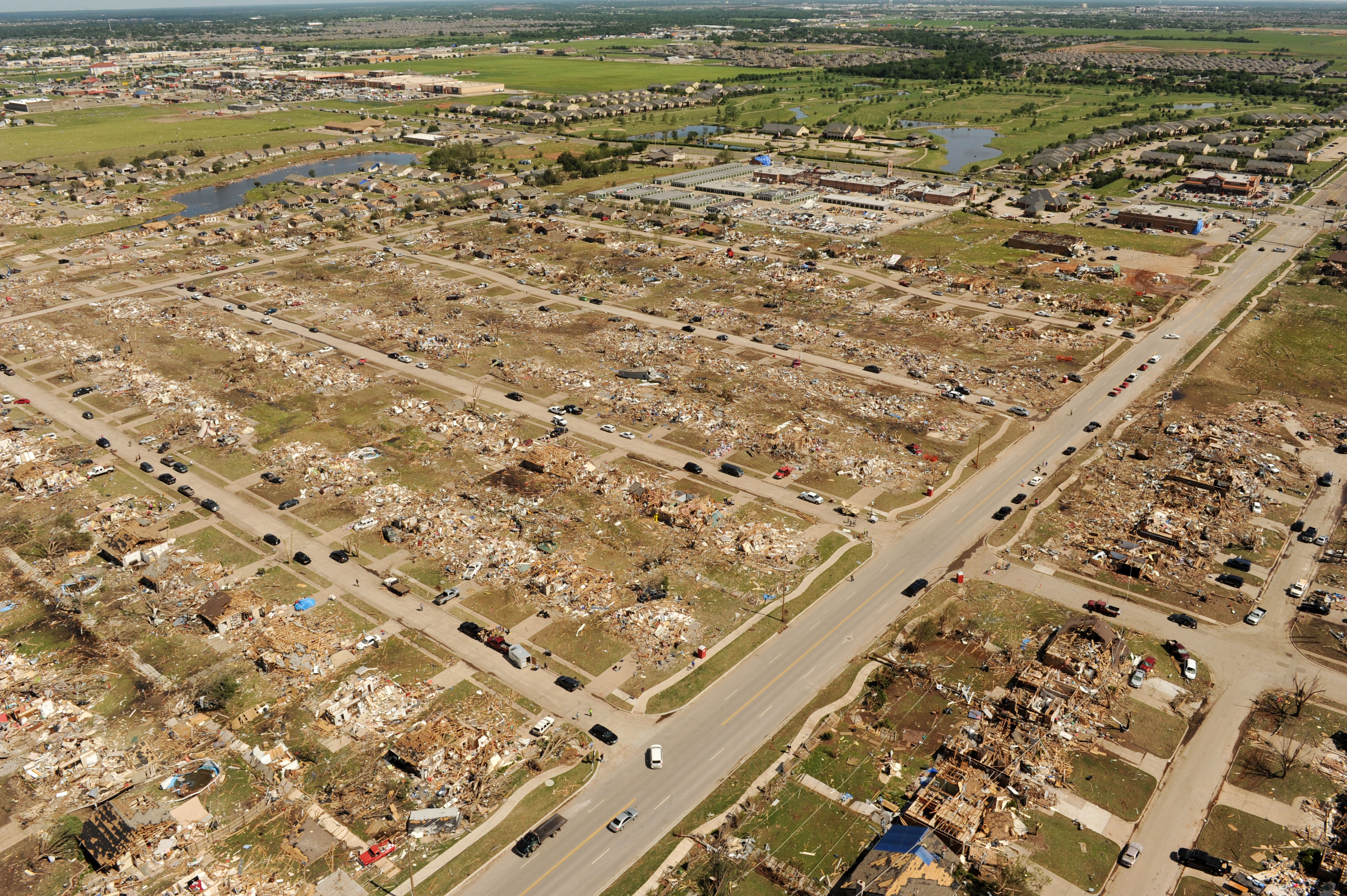
The one above? Or the one below?
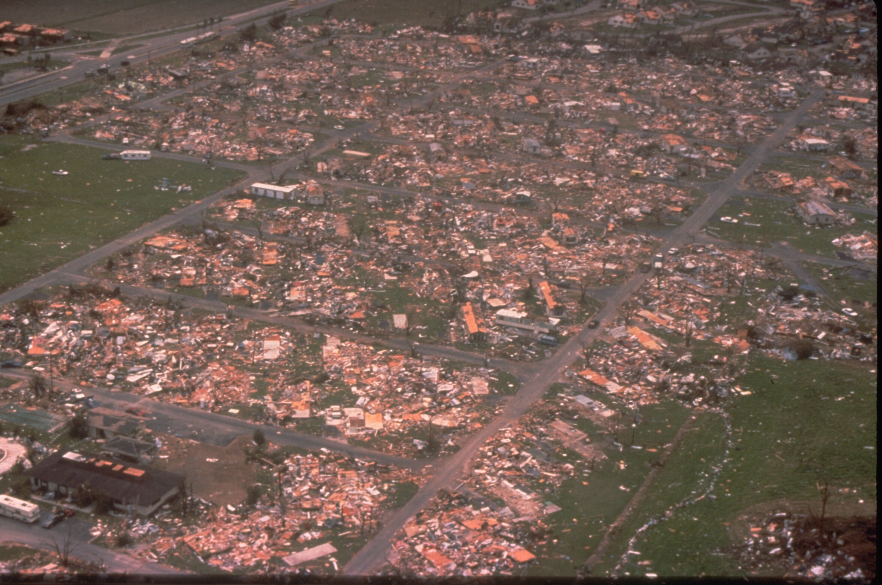
Answer:
If you picked the top image then you would be correct. That is tornado damage from Moore, Oklahoma. The second image is from Hurricane Andrew. Both events caused extreme damage.
Which is worse? I am not sure I would say either one is worse. They both caused extreme damage to homes and businesses. Both events destroyed a lot of peoples lives.
Our region has to deal with tornadoes. We do not have to deal with many hurricanes. Hurricanes weaken as they move inland. We have had to deal with high winds from dying tropical systems. We also occasionally experience heavy rain and flooding from dying tropical systems to move inland.
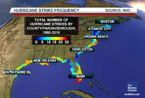
Here is the hurricane strike frequency map. What part of America normally deals with hurricanes?
If you said coastlines then you would be correct. Those who live along the Gulf Coast or East Coast have to be prepared for hurricanes during hurricane season. Hurricane season normally runs from June into November. The peak of hurricane season occurs during August and September.
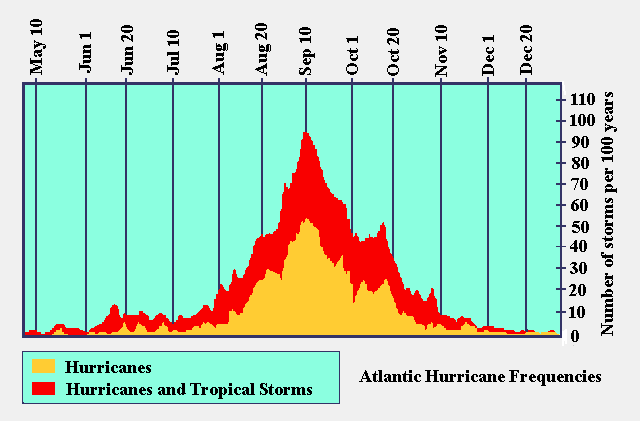
Here is the seasonal chart for hurricanes. You can see the peak is around September 10th.
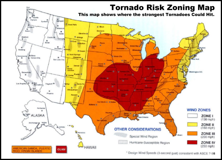
Let’s take a look at the tornado frequency map. You can see that we are in the hot zone for tornadoes. Click map for larger view.
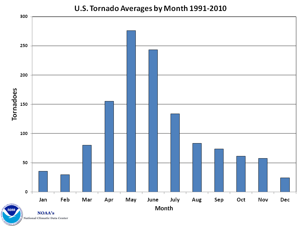
Let’s take a look at when tornadoes occur. When is the peak?
Thanks, Riley – I hope that gives you a little more insight into the difference between tornadoes and hurricanes.

No major changes in the forecast for today.

No major concerns today! Fairly calm weather.
Check out our newest sponsors $5 meal! The DQ Grill and Chill (located across from Noble Park in Paducah, Kentucky) is the newest WeatherTalk Blog sponsor! A local business helping to sponsor the weather information that you have come to love so much.
They have a Facebook Page and I encourage you to check it out. DQ Grill and Chill on Facebook


The wild card tells you where the uncertainties are in the forecast
Wild card in this forecast – no wild card today. Fairly calm weather expected through tonight.

Can we expect severe thunderstorms over the next 24 to 48 hours? Remember that a severe thunderstorm is defined as a thunderstorm that produces 58 mph winds or higher, quarter size hail or larger, and/or a tornado.
Thunderstorm threat level is ZERO


Will I need to take action?
No action required today.

How much precipitation should we expect over the next few days?
Some light rain is possible on Wednesday night.
Rainfall totals should be less than 0.15″
Not much precipitation. We could use some additional rain.
We have a new sponsor! G&C Multi-Services out of Paducah, Kentucky. G & C Multi-Services is a service provider in Western Kentucky that provides industrial and commercial equipment fabrication, machine troubleshooting, repair and maintenance, and installation. They can custom fabricate steel, stainless, and aluminum products per customer specifications.
Visit their web-site here. Or click the ad below! They have a Facebook page and it can be viewed here.


No winter weather in the forecast today.
I continue to monitor the weekend for a weather event. Still too soon to know whether that will be rain or snow. Keep checking back.

This section of the blog is speculative forecast information. Because it is past the range of what meteorologists can forecast accurately, it should be considered speculation. Anything past day 5 is considered a long range forecast.
Well, for the last week or two I have been telling you that we would see temperature take a dive as we headed into this weekend and the beginning of February. It does seem that will happen. Questions remain on just how cold temperatures will drop. Will we see a repeat of early January? It is possible.
The big question right now is concerning the storm system for this weekend. The models have been on and off in showing a southern storm system spreading moisture into our region. That still appears possible or even likely.
Temperatures are still questionable. Will it be a rain or snow or ice event? That is the question. I am hoping to have more confidence later today on how the weekend might unfold.
Right now it does appear that some precipitation will occur in our region later this weekend. Stay tuned.

Who do you trust for your weather information and who holds them accountable?
I have studied weather in our region since the late 1970’s. I have 37 years of experience in observing our regions weather patterns. My degree is in Broadcast Meteorology from Mississippi State University and an Associate of Science (AS). I am currently working on my Bachelor’s Degree in Geoscience. Just need to finish two Spanish classes!
I am a member of the American Meteorological Society. I am a NOAA Weather-Ready Nation Ambassador. And, I am the Meteorologist for McCracken County Emergency Management.
I own and operate the Southern Illinois Weather Observatory.
There is a lot of noise on the internet. A lot of weather maps are posted without explanation. Over time you should learn who to trust for your weather information.
My forecast philosophy is simple and straight forward.
- Communicate in simple terms
- To be as accurate as possible within a reasonable time frame before an event
- Interact with you on Twitter, Facebook, and the blog
- Minimize the “hype” that you might see on television or through other weather sources
- Push you towards utilizing wall-to-wall LOCAL TV coverage during severe weather events
I am a recipient of the Mark Trail Award, WPSD Six Who Make A Difference Award, Kentucky Colonel, and the Caesar J. Fiamma” Award from the American Red Cross. In 2009 I was presented with the Kentucky Office of Highway Safety Award. I was recognized by the Kentucky House of Representatives for my service to the State of Kentucky leading up to several winter storms and severe weather outbreaks.
If you click on the image below you can read the Kentucky House of Representatives Resolution.

I am also President of the Shadow Angel Foundation which serves portions of western Kentucky and southern Illinois.

We have regional radars and local city radars – if a radar does not seem to be updating then try another one. Occasional browsers need their cache cleared. You may also try restarting your browser. That usually fixes the problem. Occasionally we do have a radar go down. That is why I have duplicates. Thus, if one fails then try another one.
If you have any problems then please send me an email beaudodson@usawx.com
WEATHER RADAR PAGE – Click here —
We also have a new national interactive radar – you can view that radar by clicking here.
Local interactive city radars include St Louis, Mt Vernon, Evansville, Poplar Bluff, Cape Girardeau, Marion, Paducah, Hopkinsville, Memphis, Nashville, Dyersburg, and all of eastern Kentucky – these are interactive radars. Local city radars – click here
NOTE: Occasionally you will see ground clutter on the radar (these are false echoes). Normally they show up close to the radar sites – including Paducah.

Regional Radar – Click on radar to take you our full radar page.


Regional Radar

Please visit your local National Weather Service Office by clicking here. The National Weather Service Office, for our region, is located in Paducah, Kentucky. They have a lot of maps and information on their site. Local people…local forecasters who care about our region.


Here is the official 6-10 day and 8-14 day temperature and precipitation outlook. Check the date stamp at the top of each image (so you understand the time frame).
The forecast maps below are issued by the Weather Prediction Center (NOAA).


The latest 8-14 day temperature and precipitation outlook. Note the dates are at the top of the image. These maps DO NOT tell you how high or low temperatures or precipitation will be. They simply give you the probability as to whether temperatures or precipitation will be above or below normal.


Many of my graphics are from www.weatherbell.com – a great resource for weather data, model data, and more


This blog was inspired by ABC 33/40’s Alabama Weather Blog – view their blog
Current tower cam view from the Weather Observatory- Click here for all cameras.

Southern Illinois Weather Observatory

The Weather Observatory

Southern Illinois Weather Observatory
WSIL TV 3 has a number of tower cameras. Click here for their tower camera page & Illinois Road Conditions

Marion, Illinois
WPSD TV 6 has a number of tower cameras. Click here for their tower camera page & Kentucky Road Conditions & Kentucky Highway and Interstate Cameras

Downtown Paducah, Kentucky
Benton, Kentucky Tower Camera – Click here for full view

Benton, Kentucky

I24 Paducah, Kentucky

I24 Mile Point 9 – Paducah, KY

I24 – Mile Point 3 Paducah, Kentucky

You can sign up for my AWARE email by clicking here I typically send out AWARE emails before severe weather, winter storms, or other active weather situations. I do not email watches or warnings. The emails are a basic “heads up” concerning incoming weather conditions.